Location: 69 mi (110 km) Northwest of Cusco Map
Open: 6am- 5pm daily
Info: Av. El Sol 103, Galerias Touristicas, Cusco
Open: Mon- Sat
8:30am- 4:30pm
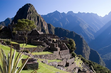
Machu Picchu is an ancient archeological Inca site 69 mi (110 km) Northwest of Cusco in Peru. Peruvian government secured 326 sq km or 126 miles as a "Historical Sanctuary" to preserve Machu Picchu archaeological site. In 1983 Machu Picchu was added to a UNESCO World Heritage Site and in 2007 it was chosen as one of the New Seven Wonders of the World.
Best Time to Visit
The dry season (roughly May–October, especially
May–September) offers the most reliable weather and clearer views.
June–August are the driest but also the busiest. Shoulder months like
April–May and September–October balance good conditions with somewhat
fewer crowds and greener scenery from recent rains. The rainy season
(November–March) brings lush landscapes and lower visitor numbers but
higher chances of clouds, mist, rain, and occasional disruptions (such
as landslides affecting trains). February is typically the wettest and
quietest; the classic Inca Trail closes that month.
For 2026,
high-season dates with a higher daily cap (up to 5,600 visitors) include
January 1, April 2–5, June 19–November 2, and December 30–31; other days
are capped at about 4,500. Book popular slots and trains well ahead for
peak periods.
Tickets, Circuits, and Rules (2026)
Buy only on
the official platform tuboleto.cultura.pe. Tickets are for a specific
date, entry time slot (generally hourly from about 6:00 a.m. to
mid-afternoon), circuit, and route. They are personalized to your
passport/ID (which must match exactly at entry). There is a limited
grace period (around 30 minutes in regular periods, up to 45 in busier
ones). No same-day gate sales at the citadel itself. Limited next-day
tickets are available in person in Aguas Calientes (Machu Picchu Pueblo)
in the afternoon/evening, but they sell out quickly in high season.
Approximate 2026 foreign adult prices (plus a small SERNANP conservation
fee of about S/11 since May 2026): standard routes around S/152–163
total; mountain or specialty routes (Huayna Picchu, Machu Picchu
Mountain, etc.) around S/200–211. Students and minors get discounts with
proper ID. Prices and exact rules can change—confirm on the official
site.
Three main circuits with multiple routes (one-way paths; you
stay on your assigned route):
Circuit 1 (Panoramic): Upper
terraces and classic viewpoints (best for the iconic photo with Huayna
Picchu). Includes options like Route 1-B (Upper Terrace) or 1-A (Machu
Picchu Mountain hike). Skips much of the lower urban ruins.
Circuit 2
(Classic): Most complete for first-timers—combines upper viewpoints with
the main temples, plazas, and urban sector. Highly recommended if you
want the full experience in one visit (Routes 2-A or 2-B).
Circuit 3
(Royalty/Lower): Focuses on the lower sector; required for Huayna Picchu
(Route 3-A), Huchuy Picchu, or Great Cavern options. Does not include
the classic upper postcard view.
For a first visit, prioritize
Circuit 2. Mountain hikes (Huayna Picchu is steeper/narrower and more
limited; Machu Picchu Mountain is longer/higher) sell out earliest and
require separate tickets plus fitness and comfort with exposure. Guides
are recommended (not mandatory for individuals). Time on site is
typically limited (often ~2.5 hours for standard circuits; longer for
mountain routes). No re-entry. Site hours roughly 6:00 a.m.–5:30 p.m.,
with last entry earlier.
Banned or restricted items (enforced): bags
larger than about 40×35×20 cm, food (water in a reusable bottle is
generally OK), tripods/selfie sticks/stabilizers, drones, umbrellas (use
a poncho), aerosols, hard-soled or high-heeled shoes, strollers, walking
sticks (limited exceptions), pets, alcohol. Use bathrooms at the
entrance (none inside the citadel proper). Respect the one-way routes,
do not touch structures, and pack out trash.
Getting There
No
direct road to the site. Standard route: Cusco (or Sacred Valley) →
Ollantaytambo (by road/taxi/colectivo/bus, ~1.5–2 hours) → train to
Aguas Calientes (Machu Picchu Pueblo, ~1.5 hours) → Consettur shuttle
bus up to the entrance (~25–30 minutes, ~US$24 round-trip for
foreigners). First buses from Aguas Calientes run early (around 5:30
a.m.). Bimodal bus+train options exist from Cusco. Alternatives include
multi-day treks (classic Inca Trail requires permits via authorized
operators; Salkantay and others are more flexible) or the longer/cheaper
but less comfortable Hidroeléctrica route. Book trains (PeruRail or Inca
Rail) in advance; classes range from basic to panoramic.
Day Trip
vs Overnight in Aguas Calientes
A day trip from Cusco is possible but
long and tiring (very early start, mid-morning arrival, tight timing,
higher risk if trains delay). Staying overnight in Aguas Calientes is
strongly preferred for most visitors: easier access to early entry slots
(better light, fewer crowds, possible mist clearing), lower altitude for
better sleep, more margin for delays, and time to explore the town (hot
springs, riverside walks). Budget hotels are available; book ahead in
peak season. Arrive the day before for early tickets or mountain hikes.
Practical Visiting Tips
Acclimatize: Cusco sits much higher
(~3,400 m) than Machu Picchu (~2,430 m). Spend at least 1–2 days in
Cusco or the Sacred Valley. Hydrate, take it easy, consider coca tea;
altitude issues are more common in Cusco than at the site.
What to
bring: Small daypack (within size limits), passport + ticket (digital +
printed backup), reusable water bottle (1.5+ liters), rain poncho/jacket
(weather changes fast), layers (mornings can be cool/misty, midday
warmer), hat, sunscreen (non-aerosol), good grip shoes, insect
repellent, basic snacks for before/after (food banned inside), cash
(soles) for toilets/bus/tips, medications.
Timing and crowds: Early
slots (especially first ones after overnight) are best for light and
atmosphere. Late afternoon can also be quieter. Arrive early for the bus
and build buffer time for the 30-minute grace window.
Guide: Highly
recommended for history and context; hire licensed ones in Aguas
Calientes or book via tour.
Photography and behavior: Follow circuit
rules, no drones or stabilizers, respect restricted areas. The classic
view is excellent on Circuits 1 or 2.
Costs (rough foreign adult
estimates): Entry ~$40–60+, bus ~$24 RT, train from Ollantaytambo
~$50–90+ each way depending on class/time. Total day costs add up
quickly; packages can simplify logistics.
Other: Safety is generally
good for organized visits. Check weather and train status. Combine with
the Sacred Valley. For multi-day, consider two circuits if possible
(e.g., 2 then 1).
Inca Origins and Construction
The Inca Empire expanded rapidly
in the 15th century under rulers such as Pachacuti Inca Yupanqui
(traditionally dated to rule from about 1438 to 1471). Pachacuti
transformed a highland kingdom centered on Cusco into a vast empire
stretching along the Andes. Archaeological and ethnohistorical
evidence points to Machu Picchu as one of his private royal estates
(panaca holdings), established after Inca expansion into the lower
Urubamba Valley. Such estates served the ruler and his lineage for
residence, ceremony, administration, and production rather than
functioning as large ordinary cities.
Traditional chronologies
based on Spanish colonial chronicles place construction in the
mid-15th century (around 1450). A major 2021 study using accelerator
mass spectrometry (AMS) radiocarbon dating on human remains from
burial caves around the site revised this picture: occupation spans
roughly c. 1420 to 1530/1532. This suggests activity began earlier
than the conventional date of Pachacuti’s rise and continued into
the early Spanish period. Construction likely involved Pachacuti and
his successor Túpac Inca Yupanqui. The site was never completed in
every detail; unfinished walls and quarries remain visible.
Builders used local granite, shaped with stone hammers and fitted in
classic Inca ashlar (dry-stone) masonry so tightly that joints often
require no mortar and can resist seismic movement. Massive stones
were quarried nearby and maneuvered with ramps, levers, and
manpower. Extensive agricultural terraces stabilized slopes,
prevented erosion, created microclimates, and supported crops. A
sophisticated water system of springs, channels, and fountains
supplied the site.
Purpose and Life at the Site
Scholars
widely interpret Machu Picchu as a multi-functional royal retreat
rather than a major administrative capital or military fortress. It
combined elite residential quarters, ceremonial and religious
spaces, astronomical observation, and agricultural production. Key
structures include the Temple of the Sun (a curved masonry tower on
a rock outcrop with alignments to solar events), the Temple of the
Three Windows, the Intihuatana stone (linked to solar rituals and
often called the “hitching post of the sun”), and various plazas and
compounds. The layout integrates architecture with the sacred
landscape of surrounding peaks and the river below.
Population
estimates generally range from a few hundred to around 750–1,000
people at peak, including elites, retainers, priests, and workers
drawn from different regions of the empire. Burials and artifacts
show a mixed population with ties to highland and other areas. The
site was part of a network of related settlements and roads in the
area (including along the route now known as the Inca Trail).
Abandonment
Machu Picchu was occupied for less than a
century. It was abandoned around the 1530s amid the Spanish conquest
of the Inca Empire. There is no evidence of Spanish attack or
occupation at the site itself; the conquistadors never found it.
Likely causes include the broader collapse of Inca state systems
that supplied and supported the estate, civil conflict, and
epidemics (such as smallpox) that devastated Andean populations
before or during the conquest. Residents left or died, and the
thatched roofs and perishable elements decayed while the stonework
endured. Local farmers later used the terraces.
Rediscovery
and the “Lost City” Narrative
The site was never completely
unknown. Local people knew of the ruins and farmed parts of the
terraces. In 1902, Peruvian explorer Agustín Lizárraga visited and
left an inscription. On July 24, 1911, American historian and Yale
lecturer Hiram Bingham III, searching for Vilcabamba (the true last
capital of Inca resistance), was guided by local farmer Melchor
Arteaga to the ridge. Bingham found well-preserved walls amid
vegetation, documented the site extensively, and publicized it
(notably in a 1913 National Geographic issue). Subsequent
excavations and clearings revealed the full extent of the complex.
Bingham initially believed he had found the lost capital of
Vilcabamba; later research identified that site elsewhere (Espiritu
Pampa). Artifacts he removed to Yale were later repatriated to Peru
after a long dispute. The popular “Lost City of the Incas” label is
somewhat misleading: the site was known locally and had been
visited, but Bingham’s scientific documentation and publicity made
it internationally famous.
Name and Later Recognition
“Machu Picchu” is Quechua for “Old Peak” or “Old Mountain.” Recent
archival research has suggested the original Inca name may have been
Picchu or Huayna Picchu, and that the modern name arose from
Bingham’s interactions with local guides. The designation has stuck
for over a century.
In 1983, UNESCO inscribed the Historic
Sanctuary of Machu Picchu as a mixed cultural and natural World
Heritage Site, recognizing both the Inca architecture and
engineering and the surrounding cloud forest biodiversity (including
species such as the spectacled bear). It was named one of the New
Seven Wonders of the World in 2007. Today it is Peru’s premier
tourist attraction, managed with visitor limits and conservation
efforts to balance access and preservation.
Construction Techniques and Materials
The primary material is
local granite (sometimes described as andesite in broader Inca
contexts), quarried on-site or nearby. The ridge sits at the
intersection of geological fault lines, which fractured the rock and
made extraction easier while also providing natural drainage pathways
and a reliable spring. Stones were shaped with harder stone hammers (of
varying weights for roughing out, shaping, and polishing), bronze tools,
and abrasion; no iron or steel was used. Large blocks, some exceeding 50
tons, were moved with levers, ramps, ropes, and human labor under the
mit’a system.
Masonry falls into two main fine styles (classified by
archaeologist John Rowe):
Ashlar (coursed rectangular): Precisely
cut rectangular blocks fitted in regular courses, used in the
highest-status buildings (Temple of the Sun, parts of the Sacred Plaza).
Polygonal: Irregular multi-sided blocks fitted like a jigsaw puzzle,
common in retaining walls and some larger structures.
In both
cases the dominant technique is dry-stone (mortarless) masonry. Blocks
interlock so tightly that a knife blade or paper often cannot fit
between them. This “dancing stones” property allows slight movement
during earthquakes, after which the stones settle back into place—unlike
rigid mortared walls. Walls typically batter (lean) inward a few degrees
and are wider at the base, lowering the center of gravity. Corners are
often rounded. Doors, windows, and niches are almost universally
trapezoidal (wider at the bottom), which distributes seismic stress
better than rectangular openings. Much of the site’s engineering effort
(estimates of 50–60%) went into underground foundations, grading, and
drainage rather than visible superstructure. Roofs were originally of
wooden beams (often alder) covered in thatch (ichu grass); none survive
intact.
Rough fieldstone or mud-mortared masonry was used for
lower-status houses, storehouses (colcas), and many terrace retaining
walls. Hierarchy of finish visibly signals social and ritual importance.
Terraces (Andenes)
Hundreds of agricultural terraces (sources
cite roughly 200–700 depending on counting method) step down the slopes.
Each has a stone retaining wall backed by layered fill: large stones,
gravel, sand, and fertile topsoil. These served multiple functions
simultaneously: creating level arable land on near-vertical terrain,
preventing landslides and erosion in a high-rainfall zone (~1,800
mm/year), and managing subsurface water so it drains rather than
saturating foundations. Maize and potatoes were primary crops, though
the terraces alone could not fully support the resident population; much
food was imported. The layered drainage design is a key reason the
structures have endured centuries of heavy Andean rain.
Water
Management and Drainage
A spring on the slopes of Machu Picchu
mountain was captured and channeled through a stone aqueduct roughly 750
meters long (gradient carefully controlled for steady gravity flow) into
the urban sector. There it fed a cascade of about 16 interconnected
stone fountains (the Stairway of Fountains), with the highest reserved
for the highest-status residence. Overflow from one basin fed the next.
An extensive network of underground channels, surface drains (over 100
documented in places), and the graded terrace fills managed the heavy
rainfall, preventing erosion and foundation failure. The system still
functions in many places.
Key Structures and Spatial Organization
Approximately 150–200 buildings exist, mostly rectangular kanchas
(enclosed compounds of rooms around courtyards) of varying size and
finish. The urban sector centers on plazas and ceremonial spaces.
Temple of the Sun (Torreón): The site’s most distinctive building—a
semi-circular or curved structure unique among the mostly rectangular
architecture. It is built directly onto and around a large natural
granite outcrop that continues into a lower chamber (often called the
Royal Tomb or mausoleum). Finely cut ashlar masonry forms the curved
wall. Trapezoidal windows are aligned so that solstice sunlight falls on
specific points inside (notably the June solstice). It combines
astronomical observation, solar ritual, and integration of living rock.
Sacred Plaza and associated temples: The heart of the Hanan sector. The
Main (Principal) Temple is a three-walled structure of large rectangular
ashlar blocks with trapezoidal niches. Nearby is the Temple of the Three
Windows, whose eastern wall of precisely fitted blocks contains three
large trapezoidal openings (lintels and jambs often carved from single
stones). These face the landscape and have been linked to solar
observations, cosmological symbolism (the three worlds of Inca cosmology
or origin myths), and framing of sacred peaks. The plaza and surrounding
buildings show the finest masonry on the site.
Intihuatana (“Hitching
Post of the Sun”): A complex carved granite monolith rising from the
bedrock atop a stepped platform in the upper ceremonial area. Its faces,
planes, and angles are oriented to cardinal directions and solar events
(equinoxes cast minimal or no shadow at noon; solstices produce
characteristic shadows). It functioned as a solar calendar/observatory
and ritual focus for “tying” the sun to the earth.
Temple of the
Condor: In the lower sector, natural rock outcrops were carved and
incorporated so that they read as a condor’s outstretched wings, with a
carved head/neck below. It integrates geology, architecture, and ritual
symbolism and includes associated caves used for offerings.
Other
notable elements include the Guardian’s House, elite residences near
ceremonial zones (finer masonry), lower residential kanchas and
workshops, storehouses, numerous stairways (many carved from single
blocks or bedrock), and rock shrines (huacas) that incorporate natural
features. Sightlines frequently align buildings or openings with
surrounding apu (sacred mountain) peaks or solar positions.
Overall Design Philosophy
Inca architects at Machu Picchu did not
dominate the landscape; they amplified and dialogued with it. Natural
rock outcrops were retained and carved into buildings, altars, or
symbolic forms. The layout follows the ridge’s contours. The result is a
settlement that appears to grow from the mountain while solving extreme
engineering challenges of altitude, seismicity, steep slopes, and high
rainfall. The combination of dry-stone interlocking, batter, trapezoidal
geometry, layered terraces, and engineered water systems has allowed the
structures to survive repeated earthquakes (including the 1650 event
that damaged later Spanish colonial buildings in Cusco) and centuries of
weather with relatively little original mortar.