Location: 31 mi (50 km) from Cusco Map
Open: 7:30am- 5pm daily
Moray and Salinas de Maras (Maras Salt Mines) form one of the Sacred Valley’s most photogenic and complementary pairings, roughly 50 km (about 80–90 minutes by road) northwest of Cusco. Moray is an Inca archaeological site of concentric circular terraces; Salinas de Maras is a living, community-run salt-evaporation complex. Most visitors combine them in a half-day trip.
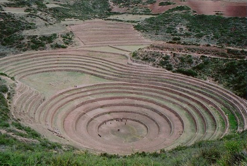
Moray: The Circular Terraces
Moray sits at about 3,500 m (11,500
ft) on a high plateau near the village of Maras. The site features
several large, bowl-like depressions (called muyus in Quechua) lined
with concentric stone-and-earth terraces. The largest is roughly 30 m
deep with multiple levels. The Incas (and possibly earlier Wari builders
for the deepest sections) engineered these into natural sinkholes or
depressions. They created deliberate microclimates: temperature
differences of up to 15 °C (or at least several degrees in measured
studies) between the upper rims and the floors, allowing experimentation
with crops suited to different Andean ecological zones. Soil samples
show materials brought from various regions, and a sophisticated
irrigation system supported the work. The precise function is not
documented in colonial chronicles (the site was “rediscovered” by aerial
survey in the early 1930s), but the leading interpretation is an
agricultural research or experimental station. Some researchers have
questioned the full scale of the temperature gradient or purely
experimental role, but the engineering is impressive either way.
Visiting Moray
Hours: Generally 7:00 a.m.–5:00 or 6:00 p.m. daily.
Ticket: Requires the Cusco Tourist Ticket (Boleto Turístico). Partial
Circuit III (Sacred Valley: Moray + Ollantaytambo, Pisac, Chinchero) is
S/70 for foreigners (valid 2 days); full integral ticket is S/130 (valid
10 days, covers more sites). No single-entry cash option at the gate.
Buy in Cusco or at qualifying sites; cash in soles preferred.
Access
rules: Stay on designated upper perimeter paths and viewpoints.
Descending into the bottom of the circular terraces is prohibited to
protect the structures. The rim walk is gentle; the site itself needs
45–75 minutes.
What to do: Walk the viewpoints for the full geometric
effect (especially striking from above), photograph the concentric rings
against the plateau and distant peaks, and read any informational signs.
A guide adds useful context on the engineering and agriculture. There is
a mirador (viewpoint) worth stopping at before the main entrance if you
have a private driver.
Altitude and intense UV are
factors—acclimatize first in Cusco or the valley, walk slowly, and stay
hydrated.
Salinas de Maras: The Salt Pans
A short drive from
Moray (roughly 15–20 minutes), the Salineras de Maras cascade down a
steep canyon slope at about 3,200 m. Thousands of small, shallow
evaporation ponds (estimates range from ~3,000 to more) are fed by a
hypersaline natural spring (Qoripujio or similar local name). The spring
originates from ancient geological salt deposits. Salt has been
harvested here since pre-Inca times (evidence linked to Wari and earlier
cultures; ceramics from centuries BCE), expanded under the Incas, and
continuously used through colonial and modern eras. Today the community
of Maras (via an entity such as Marasal) owns and operates the pans.
Families inherit or control individual ponds. Workers channel water,
allow solar evaporation over days to weeks, then scrape the crystals by
hand. Production peaks in the dry season; yields are roughly 150–200 kg
per pond per cycle. The salt (often pinkish or white, with mineral
traces) is sold locally and as a gourmet product. Legend ties the spring
to Ayar Kachi, one of the mythical brothers associated with Cusco’s
founding.
Visiting Salinas de Maras
Hours: Roughly 8:00
a.m.–5:00 p.m. daily (confirm locally).
Ticket: Separate community
fee, typically S/15–20 for foreigners (lower for Peruvians/residents;
cash soles only—bring small bills). Not covered by the Boleto Turístico.
Access rules: Since around 2019, visitors must stay on designated
viewpoints, platforms, and peripheral paths. Walking on the dikes
between active ponds or entering the pans is prohibited to protect the
salt quality and workers. The path is mostly gentle with some slopes and
can be slippery from moisture or salt residue. Allow 45–90 minutes.
What to do: Admire the geometric mosaic of white, pink, beige, and brown
ponds against the reddish canyon walls and mountains. Watch (from a
distance) the traditional work process. Buy local salt, flavored salts,
or related products from stalls—this supports the community. Photography
is excellent; polarizing filters help with glare.
In the dry
season the pans look brilliant white and crystalline; in the rainy
season they can turn muddier and browner while the surrounding landscape
greens up.
Combined Visiting Tips
Best time: Dry season
(May–October) for clear skies, reliable sunshine, best photography, and
active salt evaporation. Shoulder months (April/May and
September/October) balance weather and fewer crowds. Rainy season
(November–March) brings lush green terraces at Moray and fewer visitors,
but possible mud, slippery paths, and cloudier views. Arrive early
(before 9:00–9:30 a.m.) or later afternoon to avoid the main tour-bus
rush (peak roughly 9:30 a.m.–12:30 p.m.).
Getting there from
Cusco:
Organized half-day group tours (often including Chinchero
weavers): easiest and cheapest (~$15–30+ depending on inclusions; check
whether tickets are included). Many depart ~7:30–8:30 a.m. and return
early afternoon.
Private taxi/driver for the day: more flexibility
for pacing and photo stops (~$70–120 or so for the vehicle, negotiable).
Ideal if combining with lunch or other stops.
Public transport:
Colectivo toward Urubamba/Chinchero from Pavitos or similar terminals,
get off at the Maras turnoff, then local taxi or mototaxi to the sites.
Cheapest but least convenient and requires transfers both ways.
ATV/quad tours: Popular adventure option—ride across the plateau between
the sites, then walk in. ATVs usually park outside the restricted areas.
From Urubamba or Ollantaytambo the distances are shorter if you are
already based in the valley.
Practical essentials:
High-SPF
sunscreen, hat, sunglasses, and layered clothing (mornings/evenings
cool; strong sun and wind; little shade).
Sturdy closed-toe shoes
with good grip.
Plenty of water, snacks, and cash (soles) for
tickets, tips, and purchases. Restrooms are basic and may require small
fees.
Passport or ID (sometimes requested).
Allow 4–6+ hours total
for the round trip and both sites, or longer if adding Chinchero, lunch
in Urubamba/Maras, or a more relaxed pace. Half-day is standard;
full-day is more comfortable.
Altitude awareness: both sites are
high. Move slowly if not fully acclimatized.
Respect rules and
workers. Do not litter or step outside designated areas.
Photography:
Early morning or late-afternoon light is best for both the geometric
terraces and the salt-pan colors/shadows.
Moray: The Circular Terraces
Moray consists of large natural karst
sinkholes (dolines) that were modified into concentric circular (and
some oval) agricultural terraces. The largest depression is about 30 m
deep, with multiple terraced levels connected by projecting stone steps
(sarunas). The site includes irrigation features and sits on a high
plateau.
Pre-Inca and Inca history. The area was occupied before the
Inca by local groups, including the Maras-Ayarmaca (or Ayar Macas) and
earlier cultures such as Chanapata. Some researchers have suggested that
the deepest terraces may show pre-Inca (possibly Wari, roughly 6th–10th
centuries CE) construction, though this is debated; detailed engineering
studies (notably by Kenneth Wright and collaborators) argue that the
visible terraces are primarily imperial Inca work from the Late Horizon
(roughly 15th to early 16th centuries), built during the empire’s
expansion under rulers such as Pachacuti and his successors.
The
Incas transformed the natural depressions into a sophisticated system of
concentric terraces. Orientation, depth, and exposure create marked
microclimates: temperature differences of up to about 15°C (or 27°F) can
occur between the top and bottom levels, with colder air pooling in the
basins. Soils appear to have been brought from different regions. This
design has long been interpreted as an agricultural research or
experimental station—allowing Inca specialists to test, acclimatize, and
select crop varieties (maize, potatoes, and others) for the empire’s
extreme vertical ecology, from lowland Amazon to high Andean zones.
Alternative or complementary theories include a primarily
ceremonial/religious function linked to agricultural cycles, fertility,
and huacas (sacred features), or a hybrid role. Wright’s engineering
analysis of hydrology, surveying, and incomplete irrigation systems
concluded that Moray was more likely a planned ceremonial center that
was never fully finished before the Spanish conquest, rather than a
fully operational agricultural laboratory. Other ideas (such as an
earlier open-pit mine later reused) exist but are less central.
After
the Spanish arrival (around 1532–33), the site was abandoned, became
overgrown, and largely forgotten in colonial records. It was
rediscovered for the wider world in 1931–32 when the Shippee-Johnson
aerial photographic expedition photographed it from the air; the images
were published soon afterward and brought the site to archaeological
attention. It is now protected as national cultural heritage and is a
major tourist site (accessible with the Cusco Tourist Ticket).
Salinas de Maras (Salt Mines / Salt Pans)
A short distance away, on
the slopes of Mount Qaqawiñay (or Qoripujio area), thousands of shallow
terraced evaporation ponds cascade down a hillside. They are fed by a
warm hypersaline spring (Qoripujio or similar local names).
Geologically, the salt originates from ancient marine deposits (linked
to the Maras Formation, tens of millions of years old) trapped and later
released by Andean uplift. The ponds number roughly 3,000–4,500 (or more
in some counts), each typically a few square meters and about 30 cm
deep, with stone-and-clay retaining walls and a network of channels that
distribute the brine.
Long history of continuous use. Exploitation
dates to pre-Inca times. Archaeological evidence includes Chanapata
ceramics (Early Intermediate Period, around or before 700 BCE) and later
Killke and Inca material in nearby sectors such as Pakallamoqo. Early
ponds may have been built or used by Wari or other pre-Inca groups; the
system was expanded and integrated into Inca trade and food-preservation
networks (salt was vital for preserving food, trade, and possibly ritual
uses). A local legend associates the spring with the tears of Ayar Kachi
(or Ayar Cachi), one of the four Ayar brothers in Inca origin myths who
was said to have been imprisoned by his siblings.
Unlike many other
Andean sites, the salt works were never abandoned. In the colonial
period, ownership stayed initially with Inca noble descendants (figures
such as Don Felipe Topa Yupangui and Don Alonso Titu Atauchi appear in
records). A 1591 royal decree documented distribution among families and
communities. Control later shifted among ayllus (including Maras,
Pichingoto, and Cachic), then to private owners in the 19th century amid
disputes. In 1969 the Peruvian state took over extraction and
commercialization (via EMSAL); local communities regained management in
1980 through Marasal S.A., owned by residents of Maras and Pichingoto.
Today, hundreds of families own individual ponds that are inherited
within the community; sale is restricted to local residents. Production
remains largely traditional: ponds are filled, water evaporates, and
salt is harvested by hand (best quality in the dry season, May–October;
the pinkish hue comes from trace minerals). Layers serve culinary, bulk,
and industrial/agricultural uses. Nearby pre-Hispanic storage structures
(such as Kachiraqay/Collanaguasi) underscore its long economic role.
The site was declared national cultural heritage (1998) and has been
nominated for UNESCO World Heritage status. It remains an active
production site and major tourist attraction, with visitors viewing the
geometric white-and-pink pans from designated areas.
Shared
Context and Significance
Both sites sit in the same highland zone
near Maras village (founded as a Spanish villa in 1556) and illustrate
Andean mastery of vertical ecology, water, and resources. Moray
highlights experimental or ritual adaptation of agriculture across
microclimates; Salinas de Maras shows enduring, community-managed
extraction of a vital commodity. Together they form a classic Sacred
Valley day-tour pairing and demonstrate the continuity of Andean
technology and land use from pre-Inca times through the Inca Empire,
colonial era, and into the present.