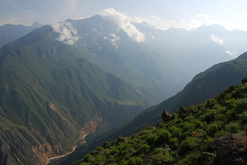
The Colca Valley is located in the province of Caylloma. Colca
comes from the words Collaguas and Cabanas, two ethnic groups that
lived along the Colca River. This canyon has a depth of 4,160 m, and
is the fourth deepest canyon on the planet.
The province of
Caylloma, generically designated as "Colca", is part of the
department of Arequipa, in Peru, and is located in the extreme
northeast of this region. The province has the Colca Canyon as its
main stage and it is in its surroundings that the populations that
identify it have settled.
Caylloma, whose name comes from one
of the local towns, has an area of 11,990.24 km² and borders the
department of Cuzco to the north, the provinces of Camaná and
Arequipa to the south, and the department of Puno. to the east, with
the province of Castilla to the west and the province of Condesuyos
to the northwest.
In 2019, UNESCO declared the Colca Canyon
and Andagua Volcanoes a global geopark. It is one of the largest
tourist destinations in Peru.
How to Get There
Almost all visitors start from Arequipa (altitude
~2,335 m). The drive takes 3–4 hours to Chivay (the main gateway town at
~3,600 m) and longer to viewpoints or Cabanaconde. The road climbs over
the Patapampa pass (~4,800–4,910 m), with stops for volcano views, stone
cairns (apachetas), and the Salinas y Aguada Blanca National Reserve
(good for vicuñas, alpacas, and llamas).
Organized tours (most
practical for most people): 1-day, 2-day/1-night, or multi-day trekking
packages. Day trips leave extremely early (often 3–5 a.m.). 2-day tours
are widely recommended for better pacing.
Independent travel: Public
buses or colectivos from Arequipa’s Terminal Terrestre to Chivay or
Cabanaconde (cheaper but slower and less flexible). Private transfers or
taxis are options for groups. Independent travel works best with
Spanish, flexibility, and prior Peru experience.
Cruz del Condor
is about 42 km beyond Chivay (near Cabanaconde). Base yourself in Chivay
(convenient, markets, restaurants), Yanque (quieter, attractive plaza),
or Cabanaconde (best for trekking).
Best Time to Visit and Condor
Watching
Dry season (roughly April/May–November) is best overall:
clearer skies, more reliable roads and trails, stronger thermal currents
for condors, and better photography. May–October is peak for conditions;
July–August is busiest. Shoulder months (April, September–October) offer
a good balance of weather and fewer crowds.
Rainy season
(December–March) brings greener landscapes and fewer visitors but more
clouds, afternoon rain, muddier trails, and less predictable condor
activity. Roads can occasionally be affected.
Condors at Cruz del
Condor: Arrive by ~7:30–8:30 a.m. and stay until ~10 a.m. (or later).
Condors rely on rising thermals that form as the sun warms canyon walls;
activity is strongest mid-morning. They can pass very close to the
platforms. Sightings are common in dry-season mornings but never
guaranteed—wild birds do not perform on schedule. An afternoon return
window (roughly 3–5 p.m.) exists but is less reliable. There are
platforms and a path along the rim; move between spots. Bring binoculars
if possible and dress in layers (cold early, strong sun later).
Main Attractions and Activities
Cruz del Condor viewpoint (~3,800 m):
Iconic for condors and the scale of the canyon (drop of around 1,200 m
to the river here).
Villages: Chivay (markets, plaza, gateway),
Yanque (attractive square, churches, quieter stays), Maca, Cabanaconde
(trekking hub). Expect colonial churches (some earthquake-damaged and
restored), local embroidery, and traditional dress. Ask before
photographing people.
Pre-Inca terraces and viewpoints: Scattered
along the route; dramatic agricultural landscapes.
Hot springs: La
Calera (near Chivay, ~3,600 m; multiple pools ~38–40°C, entry typically
S/10–20, facilities including changing rooms; convenient and popular on
overnight tours). Yanque/Chacapi options are more rustic or scenic near
the river. Bring swimsuit, towel, and sandals. Soaking is restorative
after cold, high-altitude days.
Wildlife and scenery: Vicuñas and
other camelids en route; giant hummingbirds and other birds in the
valley; volcano panoramas.
Trekking: Classic routes start near
Cabanaconde and descend steeply (~1,000–1,200 m) to the canyon floor
(Sangalle oasis ~2,100 m with pools and basic lodges, or Llahuar/San
Juan de Chuccho). Overnight at the bottom, then climb out early (often
4:30–5 a.m.; mules can be hired for the ascent). 2-day (one night at
oasis) or 3-day versions are popular. Trails are steep and exposed; the
climb out is the hardest part due to altitude, heat, and fatigue.
Independent hiking is feasible (accommodation and food available along
routes); guided tours handle logistics. Physical fitness and
acclimatization matter.
Other options: Short walks, cultural visits,
occasional rafting or biking (more specialized).
Practical Tips
Altitude and acclimatization: The route includes high points near 4,900
m. Spend at least one night (preferably more) in Arequipa before going
up. Hydrate, avoid heavy alcohol the night before, eat lightly for early
starts, and move slowly at high viewpoints. Symptoms (headache, fatigue,
shortness of breath) are common. For trekking, the ascent is demanding
even for fit people. Carry altitude medication if recommended by a
doctor and travel insurance that covers high-altitude activities.
Tickets: Mandatory Boleto Turístico del Colca (AUTOCOLCA), covering the
canyon circuit, viewpoints, and related areas. Foreign adults: S/70;
Latin American adults: S/40; children 6–15: lower rates; under 5 free.
Pay in cash (soles) at the checkpoint (often near Chivay). Usually not
included in tour prices—confirm and budget separately. Ticket is
typically for one entrance/visit.
Costs (approximate, 2026): 1-day
group tours often $30–50+ (excluding ticket); 2-day tours higher and
better value for most; trekking packages vary widely (budget independent
options can be lower). Hot springs S/10–20. Meals, snacks, tips, and
local transport extra. Cash is essential in smaller towns (limited
ATMs).
Packing essentials:
Layers (warm fleece/jacket for
mornings, high pass, and evenings; lighter for midday sun).
Sturdy
hiking shoes (even for viewpoints).
Sun protection: hat, sunglasses,
high-SPF sunscreen (intense UV at altitude).
Water
bottle/electrolytes, snacks.
Cash in soles.
Passport/ID.
Swimwear and towel if doing hot springs.
For treks: headlamp, power
bank, basic first aid, blister care, insect repellent (oasis areas),
smaller backpack.
Optional: binoculars, altitude meds,
motion-sickness tablets for winding roads.
Other tips:
Overnight stays (Chivay or Yanque) are strongly preferable to pure day
trips—less rushed, better condor timing, time for hot springs and
atmosphere.
Book reputable operators for tours/treks; check
inclusions (meals, lodging quality, ticket, guide language).
Etiquette: Support local businesses, respect communities, stay on
trails/platforms, avoid drones that disturb wildlife or people.
Safety: Trails can be steep and exposed; weather changes quickly; roads
are high and winding. Inform someone of plans if independent. Insurance
recommended.
Food: Local specialties include quinoa soup, trout,
alpaca, rocoto relleno, and Andean staples. Markets in Chivay are
useful.
Suggested Approaches
Limited time: 1-day tour
(highlights only; very early start and long drive).
Recommended for
most: 2-day/1-night tour—arrive, viewpoints or relaxed day, overnight,
morning condors, hot springs, return.
Active travelers: 2- or 3-day
trek into the canyon (add a rest/acclimatization day beforehand if
possible).
Combine with Arequipa (white city, volcanoes, cuisine) for
a fuller southern Peru experience.
Dimensions and Scale
The canyon stretches approximately 70–100 km
(43–62 mi) in length, with the deepest sections in the western/lower
reaches (around the Huambo area and near Cabanaconde). Maximum depth is
widely cited as about 3,270 m (10,730 ft) from the highest rim points
(such as Nevado Bomboya) to the river below; some measurements reach
around 3,400 m. The river floor sits near 1,066 m (3,497 ft) at its
lowest measured points, while rims range from roughly 3,000–4,350 m, and
nearby volcanic peaks exceed 6,000 m.
This makes Colca roughly twice
as deep as the Grand Canyon (whose maximum depth is about 1,857 m /
6,093 ft). Nearby Cotahuasi Canyon is slightly deeper (around 3,535 m).
At viewpoints such as Cruz del Cóndor, the river lies roughly 1,200 m
below the rim. The upper reaches form a broader valley (Valle del
Colca); the lower reaches become a steep, often V-shaped gorge.
Geological Formation and History
Colca Canyon is a product of Andean
uplift driven by the subduction of the Nazca Plate beneath the South
American Plate, combined with tectonic faulting (especially the Colca
fault system), extensive volcanism, and sustained river erosion.
Incision of a primitive canyon began around 10 million years ago; the
present landscape largely took shape in the last million years through
ongoing uplift, deglaciation, and erosion.
The canyon walls expose an
exceptional geological section spanning roughly 1.8 billion years:
Paleoproterozoic metamorphic basement at the base.
Folded and faulted
Jurassic–Cretaceous sedimentary rocks (including the Yura Group),
sometimes containing marine fossils.
Thick Cenozoic volcanic cover:
Eocene–Miocene units overlain by Plio-Pleistocene and Quaternary
volcanics (tuffs, ignimbrites, lava flows).
Volcanic activity has
repeatedly modified the landscape. Lava flows and a major rock avalanche
from Hualca Hualca created a natural dam that temporarily blocked the
river, after which renewed incision deepened the gorge. Active
geothermal activity produces hot springs (notably La Calera near
Chivay). The region remains seismically and volcanically active, with
Sabancaya volcano (≈5,976 m) having erupted in recent years.
The
Colca River and Surrounding Relief
The Colca River originates high in
the Andes (headwaters above 4,000 m, fed by glacial melt and springs;
nearby Nevado Mismi is linked to Amazon River headwater claims). It
flows generally westward, dropping steeply through the canyon before
emerging as the Majes and then Camaná River, which reaches the Pacific
Ocean. Average gradient is low overall, but the canyon section is much
steeper. Elevations transition from puna highlands used mainly for
livestock (>3,500–4,000+ m) through agricultural mid-elevations to
warmer canyon-floor zones.
Towering volcanoes frame the canyon:
Ampato (6,288 m, extinct; site of the “Juanita” ice mummy), Coropuna
(≈6,377–6,425 m), Sabancaya (active), and Hualca Hualca. These
contribute both dramatic scenery and volcanic deposits that the river
has cut through.
Landscape, Terraces, Settlements, and Human
Geography
The upper and middle valley features some of the most
extensive and best-preserved pre-Inca agricultural terraces (andenes) in
the Andes—built by Collagua and Cabana peoples more than 1,000–1,400
years ago and still farmed today (quinoa, potatoes, corn, barley, and
other crops). These stepped fields cover large areas, create
microclimates, manage water and erosion, and give the landscape its
distinctive patterned appearance. The name “Colca” derives from qolqa
(storehouses) used by these cultures.
Key settlements sit along the
rims and valley:
Chivay (≈3,635 m): Main hub and gateway town,
with services and nearby La Calera hot springs.
Yanque and other
villages: Traditional communities with colonial churches.
Cabanaconde
(≈3,287 m): Western base for trekking to the canyon floor (including the
Sangalle “Oasis”).
The landscape shifts from wider, terraced
valley sections east of Chivay to steeper, deeper canyon walls farther
west, with slopes often exceeding 60° and some near-vertical cliffs.
Foot trails, hanging bridges, and oases appear in the lower canyon.
Climate and Ecological Zones
The climate is cool, semi-arid to
arid high-Andean, with strong diurnal temperature swings more pronounced
than seasonal ones. Dry season (roughly April–October) brings sunny days
and cold nights (frequently below freezing at higher elevations,
especially June–August). Wet season (roughly November–March/April)
brings more precipitation, with February often the wettest. Annual
rainfall varies by elevation (typically hundreds of mm, higher in the
puna). Daytime temperatures can feel warm under the intense
high-altitude sun; nights cool rapidly.
Vegetation and land use
follow elevation:
High puna (>≈3,500–4,400+ m): Ichu grasslands,
cushion plants (yareta), livestock (alpacas, llamas, vicuñas).
Mid-elevations: Agricultural terraces with quinoa, potatoes, corn,
barley, beans.
Lower canyon: Warmer, drier scrub and cactus zones
supporting fruit trees (avocado, peach, apple, lúcuma) in places, plus
arid high-desert vegetation.
Wildlife
The canyon is famous for
Andean condors (Vultur gryphus), which use the steep walls and thermals.
Cruz del Cóndor is the classic viewing point where they often soar at
eye level in the mornings. Other species include giant hummingbirds,
Andean geese, Chilean flamingos, mountain caracaras, vizcachas, Andean
foxes, deer, and vicuñas on the higher plateaus.
The original Witiwiti (Wititi) dance of the natives of Tapay, in the
Colca Valley of Arequipa, Peru, is one of the region’s most distinctive
living traditions. It originated among the people of Tapay (linked to
the ancient Ccaccatapay culture) as a pre-Hispanic expression tied to
courtship, fertility, and the agricultural cycle, particularly around
fruit harvests. Over time it evolved into a widely performed folk dance
of the Colca Valley, recognized as Intangible Cultural Heritage of
Humanity by UNESCO in 2015 (and earlier as national cultural heritage).
Young people dance it in troupes of couples during religious and
patron-saint festivals of the rainy season (roughly December to March),
coinciding with the start of the agricultural year. It symbolizes the
renewal of nature and society, the beginning of adult life, and the
strengthening of community bonds. Villages compete to present the best
ensembles, keeping the tradition vital while preserving its character.
Men traditionally wear overlapping women’s skirts (polleras),
military-style shirts, slings (hondas), and distinctive hats; women wear
finely embroidered garments with local flora and fauna motifs. Legends
explain the male attire in different ways: as a discreet way for young
men to court women without being recognized, as a warrior tactic to
deceive enemies, or as linked to Inca-era stories of political alliances
and courtship involving local Collagua princesses. The dance is learned
by observation in families, schools, and gatherings and is performed to
the music of bands. It remains a central expression of Colca identity,
especially in Tapay (where older “Machuwititis” styles and Candelaria
celebrations in early February are noted) and neighboring communities.
This dance emerges from a landscape and history of deep human occupation
in the Colca Canyon and Valley. For thousands of years people have lived
here, leaving traces of cultures that made lasting contributions. Around
5000–6000 BC, hunter-gatherers followed herds of South American camelids
and gathered plants that formed the basis of their diet. Cave paintings
and stone tools survive across the area later inhabited by the Kóllawas
(Collaguas), Ccawanas (Cabanas), and Ccaccatapay peoples. These remains
show early groups gradually domesticating plants and animals. In the
Cueva de Mollepunco at Callalli, rock art depicts gathering, hunting,
and low-relief scenes of corrals with camelids and people leading them
by ropes—evidence of the shift from hunting to herding.
Only through
collective community labor could people overcome the harsh environment
and begin shaping nature. Andean social organization enabled this
adaptation. Between roughly 200 AD and 600 AD, after long processes of
domestication, the Colca people moved toward an agrarian economy. They
built agricultural terraces (andenes), practiced rain-fed farming, and
reshaped the Andean landscape into its characteristic stepped form.
These platforms expanded the usable land in steep terrain and remain a
defining feature of the valley.
From about 600 AD to 900 AD the Wari
Empire, originating in the Ayacucho region, incorporated these
communities into its administration. Administrative centers controlled
different valleys. Rain-fed agriculture gave way to irrigated terrace
systems fed by canals, requiring advanced construction and hydraulic
knowledge. Sites such as Ccachulli (near Tuti) and Achachiwa (near
Cabanaconde) stand out as probable administrative and ceremonial centers
of this period. Farming dominated the middle and lower valley, while
herding characterized higher zones. At Cabanaconde the imposing stone
wall known as “La Trinchera” runs along slopes and small mounds to the
natural canyon walls; its base uses large stones and the upper sections
smaller ones, some worked and others rough. Ccachulli shows
circular-plan structures with vaulted elevations built of double-row
crushed stone joined by clay; the site had been used since much earlier
times, possibly the late Pleistocene or the hunter-gatherer era.
The
decline of Wari led to the rise of local societies that separated from
imperial control. The Collagua societies emerged in the north (often
associated with higher zones and pastoralism, Aymara-speaking
traditions) and the Cabana more to the south (linked to lower,
maize-producing areas and Quechua speech). These groups developed their
own political organization through lordships or curacazgos and
maintained systems of vertical ecological control—accessing resources
from different altitude zones.
Around 1450 the Collaguas and Cabanas
were incorporated into the Inca Empire under Túpac Inca Yupanqui.
Coporaque is thought to have served as a center of Inca administration.
Local stories and traditions elaborate on the Inca presence, including
variants of the “Myth of the Incarri.” In Chivay one version recounts
that during a visit by the Inca Mayta Cápac he granted specific benefits
to communities: barley and quinoa to Chivay, water to Maca, winds to
Pinchollo, maize to Cabanaconde, gold and silver mines to Tisco,
cochayuyo (seaweed) to Sibayo, and so on. These tales reflect the
vertical control of ecological floors that underpinned the ancient
economy and social organization.
Spaniards entered the area in 1535.
At that time the valley was inhabited by the Collaguas and Cabanas. For
the distribution of land to the Spanish, three “repartimientos” were
distinguished, apparently organized according to the existing social
structure of the local lordships: Yanquecollaguas, Laricollaguas, and
Cabana. Colonial policies later reshaped settlement and labor, yet many
agricultural practices, social dualities, and cultural
expressions—including dances like the Witiwiti—persisted and adapted,
linking pre-Hispanic roots to the living traditions of the Colca Valley
today.