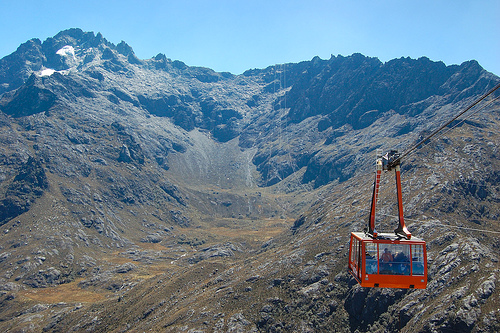
Location: Merida Map
Total length: 12. 5 km
Tel. 0274 252 5080
Entrance Fee: $26, child $18
Open: May- Nov 8- 11am Wed- Fri
8- 11:30am Sat- Sun
last trip down is at 2pm
Dec- Apr
7:30am- 12pm
last trip down is at 4pm
www.telefericodemerida.com
The Teleférico de Mérida (officially Sistema Teleférico Mukumbarí)
is one of the world’s highest and longest cable-car systems. It
covers about 12.5 km in four linked sections from the city of Mérida
(~1,577–1,640 m) up to Pico Espejo at 4,765 m, near Venezuela’s
highest peak, Pico Bolívar (4,978 m), inside Parque Nacional Sierra
Nevada.
It is an engineering landmark (original system opened
1960; fully rebuilt and reopened as Mukumbarí in 2016) that takes
you through cloud forest, páramo, and high alpine terrain with
dramatic Andean views. Full round trips with stops typically take
4–6 hours; the pure ride time is roughly 40–50 minutes each way.
Note: Operations, schedules, and which stations are open can change
due to maintenance, weather, or technical issues. Recent 2026
reports show the system operating (sometimes only to Loma Redonda
during upper-section work). Confirm status locally on arrival or via
current Venezuelan tourism sources.
Practical Information (as of late 2026 reports)
Location: Base
station Barinitas at Plaza Las Heroínas in central Mérida.
Operating
days/hours: Commonly Thursday–Sunday, 10:00 a.m.–10:00 p.m. (some
periods report more days or slight variations).
Critical cutoff: Last
ascent to Pico Espejo is typically before 2:00 p.m. Higher stations have
earlier last-ascent times (e.g., Loma Redonda ~4:00 p.m., La Aguada
~4:30–5:00 p.m.). Afternoon visibility often drops and temperatures fall
sharply.
Prices (approximate USD or equivalent in bolívares at the
official BCV rate; paid at the ticket office):
General adult
(Venezuelans): ~$20
International visitors: ~$40
Children 3–12 and
seniors (women 55+, men 60+): ~$15
Under 2 and people with
disabilities (valid card): free
VIP: ~$70 (preferential access for
two + beverages)
Physical original ID (cédula, passport, or birth
certificate) is required for discounts—photos/digital copies are not
accepted. Extra fees may apply for large backpacks. Parking is available
nearby for a small fee.
Capacity: Modern cabins hold dozens of
passengers (reports of ~36–60).
The Stations and Journey
Barinitas (~1,577–1,640 m) — Starting point in the city. Tickets, shops,
restaurants, and views toward the Sierra Nevada. Nearby Plaza Las
Heroínas is a local hangout.
La Montaña (~2,436 m) — Cloud forest
zone. Trails (e.g., interpretive paths), restaurants, event spaces, and
good birdwatching. Relatively comfortable temperatures.
La Aguada
(~3,452 m) — Transition to páramo. Panoramic views, museum/exhibit
space, café, and short trails (including toward Laguna La Fría or local
sites). Frailejones (Andean endemic plants) appear.
Loma Redonda
(~4,045 m) — High páramo with frailejones, strong mountain scenery,
café, and possible horse rides or guided walks. Trail access toward the
village of Los Nevados (several hours; requires Inparques permit
obtainable at the base). Altitude effects become noticeable—walk slowly.
Pico Espejo (4,765 m) — Highest station and a highlight. Rocky
high-alpine environment near Pico Bolívar. Viewpoint with the Virgen de
las Nieves statue, views of nearby peaks (Bolívar, Humboldt, Bonpland)
and glacial lagoons on clear days. Small café. Temperatures can be near
or below freezing; oxygen is thin. Limit time here (often recommended
around 45 minutes or less if you feel effects). Snow is possible in
season.
You can stop and explore at intermediate stations or go
straight up and descend with stops. Many visitors recommend going to the
top first (when open) for the best chance of clear views.
What to
Wear and Pack
Temperatures drop dramatically with altitude—often mild
or warm at the base, cold and windy higher up, and potentially freezing
at Pico Espejo. Layering is essential:
Base layer
(moisture-wicking)
Fleece or insulating mid-layer
Waterproof/windproof outer jacket
Warm pants, closed sturdy shoes
with good traction
Hat, gloves, scarf/buff, sunglasses, high-SPF
sunscreen, and lip balm (UV is intense)
Extra socks and a light
change if needed
Other essentials: water and snacks (food is
available but pricier at stations), cash, phone/camera, and any personal
medication. A small daypack is useful. Local guides recommend
impermeable outer layers and good footwear for walking at the top.
Altitude Sickness Tips
Rising quickly to nearly 4,800 m can cause
acute mountain sickness (AMS): headache, nausea, dizziness, fatigue, or
shortness of breath. Most people manage a short visit fine, but:
Arrive early and move slowly; avoid rushing between stations.
Stay
well hydrated (drink more water than usual; avoid heavy alcohol).
Eat
lightly.
Limit time at the highest station and descend if symptoms
worsen.
Children under 2 are often restricted from the highest
stations for safety.
People with serious heart/lung conditions should
consult a doctor beforehand.
Rest at intermediate stations if needed.
Many visitors feel better after descending.
Best Time and Weather
Mérida has a mild, spring-like climate year-round due to altitude, but
mountain weather changes quickly. Dry season (roughly December–April)
generally offers clearer skies and better views. Wet season
(May–November) brings more afternoon clouds, fog, and rain in the high
peaks. Mornings are usually clearer for the upper stations. Check the
local forecast before going—upper sections can close or have reduced
visibility in poor weather.
Additional Visiting Tips
Arrive
early on operating days if you want Pico Espejo, especially on weekends
or holidays when demand is higher.
Food and facilities: Andean
specialties (arepas, hot chocolate, soups, cheese) and cafés at
stations. Bring water and snacks as backups.
Activities: Short trails
and viewpoints at most stations; possible horse rides or guided hikes
from Loma Redonda; rock scrambling or longer treks near the top with
certified guides. Pico Bolívar itself is a technical climb (not a casual
hike).
Logistics: The base is walkable or a short taxi/bus ride from
central Mérida. Combine with city exploration (cathedral, plazas,
Heladería Coromoto).
Safety and context: Mérida is generally quieter
and more visitor-oriented than Caracas, but Venezuela carries a U.S.
State Department Level 3 (“Reconsider Travel”) advisory. Use common
sense, stay aware of your surroundings, and follow local advice. The
cable car itself is a modern, professionally operated system.
Origins and Construction (1952–1960)
The project began in 1952
when members of the Club Andino Venezolano (Venezuelan Andean Club)
proposed a cable car to ease access to the high peaks of the Sierra
Nevada for mountaineers and tourists. The idea was approved by the
government of General Marcos Pérez Jiménez. Topographic surveys followed
in 1955, and the final route was marked in 1956.
Construction started
in the mid-1950s. A cargo cable car reached the La Aguada station on 8
November 1957, allowing materials to be hauled through the cloud
forests. The system was built with major international involvement: the
French firm Applevage (specialists in cable cars) coordinated work by
about 25 companies under the direction of French specialist Maurice
Comte. German firm Heckel handled the first three sections of the
loading system; Swiss firm Habegger built the final section. Other firms
(including Eggeca for civil works and Egecom for metal structures)
contributed. Venezuelan workers performed most of the on-site labor,
supported by technicians from several countries. By mid-1958 the project
was roughly 50% complete.
The full system was inaugurated on 5 March
1960 at a cost of about 70 million bolívares (roughly US$16 million at
the time). It opened to the public that same month. Some accounts note
that an official ceremony tied to the city’s 400th anniversary was
delayed or subdued due to the death of Pope Pius XII.
The original
design consisted of four successive aerial tramway sections covering
about 12.5 km (7.8 mi) with a total elevation gain of roughly 3,188 m.
Passengers changed cabins at intermediate stations. Cabins typically
held around 36–40 people and traveled at about 5 m/s. The journey took
roughly 50 minutes.
The Stations
Five stations form the route:
Barinitas (base, ~1,577–1,640 m) in Mérida city, near Plaza Las
Heroínas.
La Montaña (~2,436 m).
La Aguada (~3,452 m), in the high
cloud forest / lower páramo transition.
Loma Redonda (~4,045–4,058
m), in the high páramo with views toward trails to the village of Los
Nevados.
Pico Espejo (4,765 m), the world’s highest passenger ropeway
station, near Venezuela’s highest peak (Pico Bolívar, ~4,978–5,007 m). A
statue of the Virgen de las Nieves stands near the station.
The
system quickly became an iconic symbol of Venezuelan tourism and
engineering, giving relatively easy access to high-altitude Andean
scenery, glaciers (in earlier decades), frailejones, and panoramic
views.
Decades of Operation and the 2008 Closure
The original
system operated for nearly five decades with periodic maintenance and
updates. It remained the highest cable car in the world and one of the
longest. Operators were often trained in France, and the international
character of the construction was still evident in later years.
By
the late 2000s the infrastructure had reached the end of its service
life. In 2008 the Austrian firm Doppelmayr inspected the system and
found severe wear on the cables (approaching 50 years of age) and
structural issues, including a crack in one tower. It recommended
permanent closure rather than further repairs. The Venezuelan Ministry
of Tourism closed the system indefinitely in August 2008 (some sources
note December) for public safety reasons.
Reconstruction and
Rebirth as Mukumbarí (2010–2016)
The government contracted Doppelmayr
(part of the Doppelmayr Garaventa Group) to build an entirely new system
rather than rehabilitate the old one. Work began around 2010–2011.
Investment figures cited in contemporary reports vary (over €100 million
in some accounts; one source mentions roughly $468 million including new
facilities). The project replaced cables, cabins, towers, and mechanical
systems and upgraded the stations into modern tourist facilities with
better amenities, museums or exhibits, and support for activities such
as hiking and birdwatching.
The new system was named Sistema
Teleférico Mukumbarí (or Mukumbari). It retained the same overall route
and five-station layout but used modern 60-passenger cabins, improved
safety systems, and higher capacity and reliability. Limited testing and
partial openings occurred in 2014–2015. A pre-commercial opening (for
children, seniors, and people with disabilities) took place on 29 April
2016. The full public reopening was on 7 October 2016.
Later
Years and Ongoing Operations
The renewed system has faced
intermittent closures for maintenance. A notable period of reduced
service occurred around 2020–2022; stations reopened progressively
(lower stations first), with full service to Pico Espejo restored by
early 2023. More recently, the system was closed from late May 2026 for
maintenance. The June 24, 2026 earthquakes delayed the arrival of parts
and equipment, postponing the planned August reopening. It resumed
commercial operations on 19 August 2026, with service seven days a week
during the remaining vacation season. Tourism Minister Daniella Cabello
highlighted upgrades including new electrical protection systems,
frequency converters, and grounding improvements, carried out with
Venezuelan labor (Ventel and Corpoelec).
The Teleférico remains a
major tourist draw for the Mérida region, offering dramatic elevation
changes from subtropical forests through cloud forest and páramo to high
alpine terrain near permanent snow and ice. It continues to be
recognized as the highest passenger cable car system in the world.
Operations are managed under the Ministry of Tourism, with fares
differentiated for Venezuelans and foreigners and restrictions
(especially for very young children) on the highest sections for safety
reasons related to altitude.