Location: San Juan Province Map
Area: 760 km²
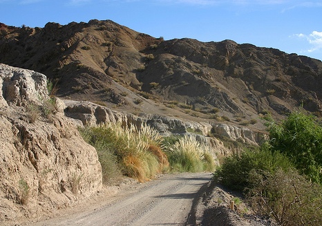
El Leoncito National Park (Parque Nacional El Leoncito) in San Juan province, Argentina, is a high, dry Andean precordillera park created primarily to protect some of the world’s clearest skies and two major astronomical observatories. It covers roughly 90,000 hectares of arid landscapes with dramatic Andes views, and the main draws are stargazing, light hiking, birdwatching, and the historic estancia setting.
Location and Getting There
The park sits about 35 km south of
Barreal (the main base town) in the Calingasta Valley, at elevations
around 2,500 m for the observatories. Access is via paved Provincial
Route 149 (RN 149). From San Juan city it is roughly 246 km; from
Mendoza about 219 km via Uspallata. The final stretch into the park
includes a dirt/ripio access road of about 12 km to the visitor
center—drive carefully, especially at night.
There is no public
transport into the park. Buses (e.g., El Triunfo) run from San Juan
to Barreal; from there you need a rental car, taxi/remis, or a local
tour. Most visitors base themselves in Barreal (hotels, cabañas,
restaurants) or camp in the park. Check road conditions before
traveling, as mountain routes can be affected by weather.
Best Time to Visit and Climate
The park is open year-round, and
each season offers different conditions for hiking or sky viewing.
Spring through early autumn (roughly October–April) is generally
most comfortable for daytime activities. Winters can drop below
freezing with strong winds. The region is extremely dry (around 200
mm of rain per year, mostly in summer) with high thermal
amplitude—days can be warm/sunny while nights are cold even in
summer. Clear skies occur on roughly 300 nights a year, making it
excellent for astronomy. Avoid full-moon periods for the best
stargazing. Check the Servicio Meteorológico Nacional forecast
before your trip.
Hours and Fees
Park entry is free. Hours
vary by season:
Summer: park entry 8–20 h; Cerro Leoncito trail
8–16 h; stay until 21 h
Autumn/Winter: park entry 9–18 h; Cerro
Leoncito 9–14 h; stay until 19 h (autumn) or 18 h (winter)
Spring: park entry 8–19 h; Cerro Leoncito 8–15 h; stay until 20 h
Confirm current hours on arrival or via the park contacts, as they
can change.
Key Attractions and Activities
Astronomical
Observatories (main highlight)
Two professional facilities sit
inside the park to take advantage of the exceptional atmospheric
clarity:
CASLEO (Complejo Astronómico El Leoncito): Houses
Argentina’s largest optical telescope (2.15 m Jorge Sahade). Day
visits (no reservation needed) run Friday–Tuesday at set times
(typically 10:30/11:30 and afternoon slots) and last 30–40 minutes
with a talk and viewing of the main telescope. Night visits
(reservation required via visitascasleo.com or WhatsApp +54
264-5853354) are Friday–Monday; some nights are observation-only,
others include optional dinner and overnight lodging with breakfast.
Observations use smaller public telescopes outdoors. No children
under 5; older visitors (especially over 70) may need a health
declaration. Pets not allowed. Book well in advance—slots fill
quickly. Avoid full moons. Cost is charged for observatory visits
(prices vary; check current rates).
CESCO (Estación de Altura
Carlos U. Cesco): Day visits Thursday–Sunday (roughly 10–12 and
16–18) and night visits with prior booking (cielodesanjuan.com or
phone). Focuses on solar observation by day and deep-sky objects by
night.
Night observations are outdoors, so temperatures drop
sharply—bring warm layers, a jacket, closed shoes, and possibly
gloves regardless of season. The park was established in part to
protect these dark-sky conditions from light pollution.
Hiking and Trails
Several trails suit different abilities:
Cascada El Rincón / Paisajes de Agua: Easy, low-elevation walks
(around 0.5–2.5 km) along the stream, with waterfall views,
interpretive signs about arid water cycles, and chances to see
birds, cuises (rodents), foxes, or guanacos. Ideal for families.
Cerro Leoncito: Medium-to-high difficulty, ~8 km round-trip (about 3
hours), 300 m elevation gain. Panoramic 360° Andes views from the
summit. Register at the visitor center beforehand.
Other options
include Mirador del Manzanar, Mirador del Cesco, and geological
trails with possible petroglyphs.
Trails are open year-round
but respect seasonal entry cut-offs for the higher ones. Wear sturdy
shoes for rocky/uneven terrain.
Wildlife and Birdwatching
Over 90 bird species, including Andean condor, choique (Darwin’s
rhea—the park emblem), Andean flicker, and various raptors. Mammals
include guanacos, foxes, and occasionally pumas (rarely seen).
Binoculars are highly recommended. The arid steppe and Andean
foothills landscapes are striking.
Other
Historic estancia
buildings, picnic areas, and nearby Barreal Blanco (Pampa del
Leoncito)—a vast salt flat popular for land sailing (carrovelismo).
Outside the park, high-altitude wineries (Malbec, Syrah) and local
culture in the Calingasta Valley are worth combining with a visit.
Camping and Facilities
Free rustic camping at Campamento El
Jarrillar (or similar designated area) near the entrance/visitor
center: tent sites, some motorhome spots, grills, tables, quinchos,
and bathrooms with hot showers (limited hours, often
evening–morning). A small proveeduría/store and eatery (Juan y
Florinda) operates on limited days (often Thursday–Monday). Bring
your own food, water, and supplies as options are basic and limited;
the park has potable water. No electricity in the camping area. Fire
is restricted to designated grills only. CASLEO offers limited
overnight rooms with advance booking.
Barreal has a fuller range
of lodging, restaurants, and services.
Practical Visiting
Tips
Clothing and gear: Layered clothing for big day-night
temperature swings. Sturdy hiking shoes, sun hat, high-SPF
sunscreen, sunglasses, and a first-aid kit. Warm jacket essential
for nights. Carry plenty of water (even though the park has some
supply) and snacks. Binoculars for birds and landscapes.
Vehicle:
Own or rental car is strongly recommended. Check fuel levels and
vehicle condition; mountain roads and dirt access require caution.
Arrive in daylight if possible, especially for the dirt section.
Reservations: Essential for night observatory visits (book months
ahead if possible). Day park visits and most trails do not require
advance booking, but register for Cerro Leoncito.
Altitude and
health: Observatories are at ~2,550 m. People with heart or
respiratory issues should take care. No young children under 5 at
CASLEO.
Conservation and etiquette: Stay on trails, do not
disturb wildlife or observatories, and help keep the skies dark. The
park exists partly to protect scientific conditions.
Contacts:
Park—leoncito.pn@gmail.com or +54 9 2646 30-4495 (or Instagram
@parquenacional_elleoncito). Confirm details close to your visit as
hours, trail status, and observatory schedules can change.
Combine with: Barreal town, nearby archaeological sites (e.g., Los
Morrillos), high-altitude wines, and other Calingasta attractions
such as the 7 Colores hills.
Elevation and Landforms
The park forms a steep environmental
gradient. Western and lower sections sit near the edge of the Calingasta
Valley at about 1,600 meters above sea level. The terrain rises eastward
across slopes, plateaus, and ridges to the crest of the Sierra del
Tontal at around 4,300 meters. Key high points in the range include
Cerro Pircas (roughly 4,340–4,380 m). Two major astronomical
observatories sit within the park at about 2,552 m.
Distinct
landscapes include:
Broad intermontane plains and valleys at lower
elevations.
Rocky slopes, quebradas (ravines), and mountain ridges.
High puna plateaus and Andean ridges with permanent snow and ice at the
uppermost levels.
Small high-altitude oases and wetlands (ciénagas)
fed by streams.
A signature feature is the Pampa del Leoncito
(also called Barreal Blanco). This is a vast, almost perfectly flat dry
lakebed (playa) roughly 10–12 km long and 3 km wide, formed by Holocene
evaporation of an ancient endorheic lake. Its surface consists of fine
white saline silts and clays that crack into polygonal patterns when
dry. The plain lies near National Route 149, just outside or adjacent to
the main park entrance area, and offers unobstructed views of the high
Andes, including Cerro Mercedario (about 6,770 m) in the Cordillera
Frontal to the west.
Geological Setting
The park sits in the
Argentine Precordillera, a structural zone of older sedimentary and
metamorphic rocks distinct from the main Andes. The Sierra del Tontal
consists largely of Paleozoic (especially Ordovician) siliciclastic
sequences—greywackes, shales, and related turbidites—deposited in marine
shelf or deeper-water settings. These rocks have been folded and
uplifted by Andean tectonics. The range runs roughly northwest–southeast
and forms the eastern boundary of the park along its watershed divide.
Paleontological sites within the park preserve fossils from these
ancient environments, adding scientific value alongside the modern
landscapes.
Hydrography
Drainage is limited and largely
internal. Streams and arroyos (including the Arroyo El Leoncito) flow
westward down the slopes of the Sierra del Tontal, supporting sparse
wetlands and small oases before water evaporates or sinks into the arid
basin. The Pampa del Leoncito/Barreal Blanco represents a classic
endorheic system where water collects and evaporates, leaving
salt-cemented sediments. An endemic fish species, the bagrecito del
Leoncito (Silvinichthys leoncitensis), survives in local waters and is
believed to have evolved in isolation during a wetter period in the
past.
Climate and Atmosphere
The climate is cold and arid to
semi-arid, with marked elevation differences:
Lower Monte zones
experience subtropical dry conditions, with summer averages near 26°C
(highs to 35°C) and winter averages near 10°C (lows to −6°C or −10°C).
Higher Puna and Altos Andes zones are colder and drier, with large daily
temperature swings and permanent ice or snow on the highest peaks.
Annual precipitation is low, typically 100–200 mm, concentrated in
summer storms. Humidity is very low, winds can be strong and dry, and
the region enjoys exceptional atmospheric clarity—more than 300 clear
nights per year with minimal light pollution or dust. These conditions
make the park one of the best sites in the Southern Hemisphere for
astronomy and explain the presence of the CASLEO (Complejo Astronómico
El Leoncito) and Félix Aguilar/Carlos U. Cesco observatories.
Ecoregions and Geographic Context
Three ecoregions meet here:
Monte de Sierras y Bolsones (roughly 59,000 ha) in the lower valleys and
plains around 1,600 m, with resinous shrubs such as jarilla and the
endangered retamo (Bulnesia retama).
Puna (about 19,500 ha) on
intermediate slopes and plateaus.
Altos Andes (about 11,200 ha) on
the highest ridges up to 4,300 m, with hard grasses (coirones) and
cushion plants such as yareta.
The park preserves a
representative sample of the Central Andean Puna and Southern Andean
steppe in relatively good condition. It also includes sections of the
Inca road system and other cultural/paleontological sites. National
Route 149 crosses about 20 km of the area, linking Barreal with
Uspallata in Mendoza.
Flora
Vegetation changes sharply with elevation and water
availability.
Lower Monte de Sierras y Bolsones (~1,600 m valleys and
plains): Dominated by resinous, drought-resistant shrubs. Characteristic
species include several Larrea (jarillas), such as Larrea cuneifolia and
Larrea nitida, with small leaves, yellow flowers, and branching from the
base that reduces water loss. The endangered Bulnesia retama (retamo) is
notable for its extremely hard wood and wax-covered young branches
(historically exploited). Other elements include various xerophytic
shrubs and, near the permanent Arroyo El Leoncito and humid pockets,
riparian or wetland plants such as pájaro bobo and cortaderas.
Higher
Puna and Altos Andes (escarpments to ~4,300 m): Hard-leaved tussock
grasses (coirones, various Stipa/Jarava-type species) form open steppes.
Low, cushion-forming yaretas (green, mat-like plants only a few
centimeters tall) hug the ground. Two plants noted as exclusive to the
zone are Mulinum echegarayi and Trichocline cinerea. Other
high-elevation shrubs include nearly leafless tolilla and aromatic
ajenjo. Cacti occur on slopes (including barrel forms and species such
as Denmoza rhodacantha). Overall, many species are xerophytic or
high-Andean specialists; the park records numerous Argentine endemics
(some restricted to San Juan or shared with Mendoza/La Rioja).
Humid microhabitats (vegas/meadows, stream edges, the irrigated oasis
area, and natural depressions) support richer communities—around 157
species in one study of wetter sites, with exotic plants comprising
~20%—including more mesic herbs and grasses important for large
herbivores. Dominant lower communities include jarillales of Larrea
nitida with Baccharis species, shifting higher to Adesmia shrubs.
Adaptations include resinous or reduced leaves, deep or spreading roots,
cushion growth forms that conserve heat and moisture, and wax coatings.
Spring brings flowering (notably retamos), while the arid landscape
remains sparse year-round.
Fauna
Wildlife is adapted to open,
rocky, arid terrain with limited water. Large herbivores and birds are
more visible on plains and near wetlands; many species are cryptic or
nocturnal.
Mammals: Guanacos (Lama guanicoe) form herds on high
plains and near vegas. Culpeo (Andean) foxes (Lycalopex culpaeus) and
pumas (Puma concolor) are present (the latter elusive). Smaller species
include cuises (Microcavia australis), tuco-tucos (burrowing rodents),
chinchillones (Lagidium viscacia) on rocky slopes, armadillos (e.g.,
Zaedyus pichiy), skunks (Conepatus chinga), and various rodents such as
Abrocoma (chinchilla rats). Some cats (pajonal and montés types) and the
elegant fat-tailed mouse opossum occur. Several mammals face local
pressure or are considered vulnerable nationally.
Birds: Over 120
species. The emblematic species is the lesser rhea or suri cordillerano
(Rhea pennata), a high-altitude runner that lives in small groups, feeds
on seeds, shoots, insects, lizards, and small rodents, and has male-only
incubation and chick-rearing. Andean condors (Vultur gryphus) soar on
thermals. Other raptors include black-chested buzzard-eagles
(Geranoaetus melanoleucus), variable hawks, cinereous harriers, and
peregrine falcons. Ground-doves (e.g., black-winged Metriopelia
melanoptera, golden-spotted, Moreno’s) are common. Seed-eaters
(comesebos/sierra-finches such as Phrygilus species, often
blue-and-yellow), miners, canasteros, thrushes (chiguanco), loicas,
agachonas (cryptic plumage), hummingbirds (Andean hillstar, giant), and
others occupy the steppes and rocky areas. Some records represent
southern range limits for puna species.
Reptiles and amphibians:
About 13 reptiles, including various lizards (Liolaemus and others, some
on rocky slopes), colubrid snakes (e.g., mousehole snake Philodryas
trilineata), and the viper Bothrops ammodytoides. Amphibians are limited
to two toads (Rhinella arenarum and R. spinulosa), mostly near water.
Fish: The park’s most remarkable endemic is the bagrecito del Leoncito
(Silvinichthys leoncitensis), a small trichomycterid catfish (up to ~6
cm) described in 2011. It is strictly endemic to the Arroyo El Leoncito
/ Cabeceras system and associated groundwater within the park—an
isolated, endorheic microhabitat of shallow, sandy/silty reaches. It is
hypothesized to have diverged after isolation from larger basins during
a wetter period. The only native fish in its streams, it feeds on algae
and detritus and was threatened by introduced rainbow trout (which have
been managed/eradicated in places). An exotic trout is also recorded.
Conservation Notes
The park protects habitats for threatened or
pressured species (guanaco, suri, retamo, the endemic catfish) and
numerous endemics, while also safeguarding clear skies for astronomy
(CASLEO and Cesco observatories). Primary values include the altitudinal
ecoregion gradient, hydrological systems supporting biodiversity,
paleontological and cultural sites (including Inca road segments and
rock art), and atmospheric quality. Main threats historically included
grazing, wood collection, and invasive species; current management
emphasizes minimal impact and research.