Location: El Chaltén village Map
Elevation: 3,359 m (11,020 ft)
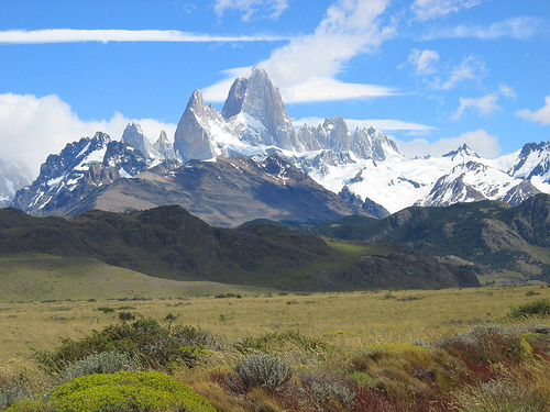
Mount Fitz Roy (Monte Fitz Roy) is a mountain on
the border between Argentina and Chile. The closest settlement
to Mount
Fitz Roy is a El Chaltén
village. Monte Fitz Roy mountain reaches a height of 3,359 m (11,020 ft).
Mount Fitz Roy is a magnificent mountain in the Andes Mountain range
on the border between Argentina and
Chile. It reaches a total height of 3405 meters above sea level.
Mountain was named by explorer Francisco Moreno who dedicated it to
Robert Fitzroy, fearless captain of the ship "Beagle", the same ship
that carried Charles Darwin around the Globe. Local Native Americans
called this peak Chalten.
Climbing Mount Fitz Roy is a
demanding job so it requires proper physical training and
appropriate gear. However you can make part of the way up the slope
and get to the Laguna de Los Tres that can be done by most tourists.
A hiking trail to the top of the peak stretches for 10 km. It begins
at the outskirts of the village of El Chalten. Here you need to get
a free permit for climbing. It is done to keep a track of all
tourists who are in the area of Mount Fitz Roy. You can get to the
village by taking a shuttle bus from El Calafate.
The hiking
trail to Mount Fitz Roy lies along a picturesque lagoon Capri and
then bends around the Rio Blanco river. Other side of the river is a
location of a tourist camping ground. Many tourists spend a night
here before making a sharp ascension up the slope. Keep in mind that
in Southern Hemisphere summer lasts between December and February.
These months is the best time to make the climb. Some adrenaline
seekers try to make it in the June, July and August months, but the
authorities of city of El Chaltern try to prevent this wreck less
behavior. While Mount Fitz Roy appears safe and beautiful, sudden
blizzards and strong winds can catch daredevils off guard.
Getting There
Fly into El Calafate (FTE). From there it is
roughly 220 km / ~3–3.5 hours by paved road (Ruta 40 then Ruta 23)
along Lago Argentino and Lago Viedma. Multiple daily buses run in
season (companies include Chaltén Travel, Cal Tur, Marga Taqsa);
fares are typically in the $30–50 USD range one way. Private
transfers or a rental car are also options. There is no airport in
El Chaltén.
Park Entry Fees (2026 season)
Fees apply to
the northern zone (Portada El Chaltén) of Los Glaciares National
Park (same rates as the southern zone / Perito Moreno area). As of
June 2026 official rates:
Foreign visitors (General): 50,000
ARS per day (~$33 USD at recent rates).
Argentine residents:
25,000 ARS; Santa Cruz provincial residents: 8,000 ARS; students
(Argentine institutions): 15,000 ARS.
Second day within 72 hours:
50% off.
Flexipass: 3 days 100,000 ARS; 7 days 175,500 ARS
(foreign rates). Annual pass options exist.
Buy online in
advance at ventaweb.apn.gob.ar (recommended) or via QR code at the
gates (card only—no cash accepted at northern portals). Carry
passport/ID and the digital ticket; rangers check at the three
portals (Los Cóndores, Base Fitz Roy / Cerro Torre, and Río
Eléctrico). Day visitors may also face a small municipal fee (often
included in bus tickets). Tickets are valid for the full day across
multiple trails.
Best Time to Visit and Weather
The
practical hiking season runs roughly October–April.
December–February offers the longest daylight (up to ~16–17 hours)
and relatively warmer conditions (daytime highs often 15–20 °C /
59–68 °F in town), but it is also the busiest and windiest. Shoulder
months (November, March–April) have fewer crowds, milder winds, and
(in autumn) colorful lenga forests. Winter (May–September) brings
snow, ice, shorter days, and is mainly for experienced hikers with
proper gear; some services reduce.
Patagonian weather is
notoriously changeable—sun, strong wind (gusts 60–80+ km/h common),
rain, and cold can all occur in a single day. Mountains frequently
cloud over by mid-to-late morning. Early starts (pre-dawn or very
early) maximize clear-view chances at the peaks. Build in weather
buffer days.
Main Hiking Trails
Trails are well-marked and
start from or near town. No technical climbing is required for the
classic day hikes (summiting Fitz Roy itself is a serious
mountaineering objective requiring registration and experience).
Stick to marked paths. Drones, fires, and dogs are prohibited.
Laguna de los Tres (classic Fitz Roy base / “the” hike)
~20–25 km round-trip, 8–10 hours, ~800–1,200 m elevation gain (most
sources cite ~1,000 m). The final ~1 km is a steep, loose, rocky
scramble gaining ~400 m—the main challenge. Reward is the turquoise
lake at the base of the sheer granite face (the classic “logo”
view). Trekking poles are highly recommended, especially for the
descent. Start very early. Alternative one-way or circular options
start from Río Eléctrico (requires a transfer). Camping at Poincenot
allows an easier sunrise approach.
Laguna Torre (Cerro Torre)
~18 km round-trip, 6–8 hours, moderate. Easier elevation profile
than Laguna de los Tres. Leads to views of the slender Cerro Torre
spire, glacier, and lagoon (often with floating ice). Good
alternative or addition. Camping at De Agostini is possible.
Shorter / moderate options
Laguna Capri (~8 km RT, 3.5–5 hours):
Excellent Fitz Roy views with less commitment; branches off the main
trail.
Miradores (Los Cóndores / Las Águilas), Chorrillo del
Salto waterfall, and other half-day or easy walks for arrival days
or bad-weather backup.
Loma del Pliegue Tumbado for panoramic
views.
Multi-day loops (combining the above plus other valleys)
are popular for those with time and camping gear.
How Long to
Stay
Most people regret only one night. Three nights is the
practical sweet spot for most visitors (allows both big hikes or one
big + shorter ones, plus weather margin). Two nights is a bare
minimum; four is better in shoulder season or if clear views of Fitz
Roy are a priority. Arrival/departure logistics eat into day-trip
options.
Packing and Practical Tips
Layers are essential:
Moisture-wicking base, insulating mid-layer, waterproof/windproof
shell and pants. Temperatures drop and wind intensifies with
elevation. Extra socks and a warm layer for the top.
Broken-in
hiking boots with good grip (rocky, loose terrain). Trail runners
are riskier on the final scramble.
Trekking poles (rentable in
town).
Daypack with food, 1.5–2+ liters water (streams exist but
treat/filter as needed), sun protection, headlamp (for early
starts), and a light down or fleece.
Check local forecasts the
morning of (general apps are less reliable); turn around if
conditions deteriorate.
Start early. Trails get crowded in peak
season. Signal is weak/nonexistent on trails—download tickets/maps
offline.
No drones. Stay on trails. Zero waste / pack out
everything.
Accommodations and Camping
El Chaltén has a
range of hotels, hostels, and restaurants along the main street
(Avenida San Martín). Book ahead in peak season.
Backcountry
campsites inside the park (Poincenot for Laguna de los Tres, Capri,
De Agostini for Laguna Torre) now require advance reservations and a
camping fee (administered by Asociación Amigos del Parque Nacional
Los Glaciares; recent reports ~30,000 ARS range—confirm current).
Limited capacity, basic facilities (toilets, water from
streams/lakes), gas stoves only, pack-out rules. Reserve via their
site before heading out. Town-based day hikes avoid the need to
camp.
Other Tips
Visitor center in town has maps and
current conditions.
Equipment rental (poles, etc.) is available
in town.
Combine with El Calafate / Perito Moreno Glacier if time
allows (same park system, but separate logistics and sometimes
separate tickets depending on zones).
Safety is generally good;
the main risks are weather, exposure on the final climbs, and
underestimating time/distance. Carry travel insurance that covers
hiking.
Autumn colors and fewer crowds make March–April
attractive for many; peak summer maximizes daylight and
clear-weather odds if you have buffer days.
Location and Setting
The mountain rises near the village of El
Chaltén in Santa Cruz Province, Argentina, within Los Glaciares
National Park (a UNESCO World Heritage Site). The Chilean side falls
in Bernardo O’Higgins National Park and the Chaltén Mountain Range
Natural Site. The Argentina–Chile border passes over the main summit
(agreed by both countries), though sections of the border farther
south remain undefined.
To the west lies the vast Southern
Patagonian Ice Field (Campo de Hielo Patagónico Sur), one of the
largest temperate ice masses outside the polar regions. To the east
the terrain drops abruptly toward the Río de las Vueltas valley and
the drier Patagonian steppe. Nearby major lakes include Lago Viedma.
The area is a classic transition zone between ice-covered highlands
and open steppe.
Geology and Form
Fitz Roy is a granite
(granodiorite) peak—a steep, pyramidal monolith shaped by intense
glacial erosion and weathering. It forms part of a compact cluster
of sharp spires and needles. Notable satellite peaks in the Fitz Roy
group include Aguja Poincenot (around 3,002 m), Aguja Saint-Exupéry,
Aguja Mermoz, and others. The nearby Cerro Torre massif lies a short
distance to the south. The rock faces are sheer, with hanging
glaciers and snowfields, giving the mountain its striking,
fortress-like appearance.
The indigenous Tehuelche (Aónikenk)
name Chaltén means “smoking mountain,” referring to the frequent
clouds and mist that wrap the summit.
Glaciers, Lakes, and
Valleys
The massif is ringed by glaciers and glacial landforms:
Multiple glaciers descend its flanks and surrounding cirques
(examples include Piedras Blancas and others feeding local lakes).
Laguna de los Tres sits at the base on the Argentine side—a
turquoise glacial lake that provides the classic postcard view of
the peaks and is reached by a popular ~20–25 km round-trip hike from
El Chaltén.
Nearby lakes include Laguna Sucia and Laguna Torre.
Meltwater feeds rivers and creates moraines, icefalls, and
silt-laden turquoise waters typical of the region.
Lower
elevations feature lenga beech forests in the valleys, giving way to
open, windswept terrain higher up.
Climate and Conditions
The geography is defined by extreme Patagonian weather. Strong winds
(influenced by the Roaring Forties), rapid storm systems, heavy
precipitation, and frequent cloud cover dominate. Temperatures swing
quickly, and the summit is often iced or obscured. These conditions,
combined with the technical granite terrain, make Fitz Roy one of
the world’s most challenging climbs despite its relatively modest
height (first ascent in 1952 by Lionel Terray and Guido Magnone).