Location: Chubut Province Map
Area: 276.74 km²
Official site
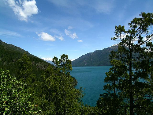
Lago Puelo National Park (Parque Nacional Lago Puelo) is one of the
more accessible and distinctive protected areas in Argentine
Patagonia. Located in northwestern Chubut Province within the
Comarca Andina del Paralelo 42, it centers on a large glacial lake
of turquoise-to-milky water surrounded by Andean-Patagonian forest
and elements of the Valdivian rainforest. Its relatively low
elevation (around 200 m / 650 ft) creates a milder microclimate than
many neighboring parks, supporting unique plant species and making
it suitable for year-round visits, with peak conditions from late
spring through early autumn.
The park covers roughly 27,000
hectares and was first established in 1937 as an annex to Los
Alerces National Park before becoming an independent national park
in 1971. It protects dense stands of pitra (Myrceugenia exsucca),
arrayán (myrtle), coihue, cypress, and rarer Valdivian species such
as olivillo, ulmo, lingue, and avellano, alongside wildlife
including the endangered huemul, pudú (the world’s smallest deer),
monito del monte (a relict marsupial), puma, Andean condor, torrent
duck, and various forest birds such as the chucao.
How to Get There
The main recreational area and park entrance lie
about 4 km from the town of Lago Puelo and 16 km south of El Bolsón
(Río Negro Province) via paved Ruta Provincial 16. From San Carlos
de Bariloche it is approximately 145 km (RN 40 south to El Bolsón,
then RP 16). From Esquel it is roughly 155–166 km via RN 40 to Cerro
Radal and a short connecting road to RP 16.
By car:
Straightforward and well-paved for most of the way. Fill up with
fuel in El Bolsón or Lago Puelo, as services are limited further
afield.
Public transport: Daily buses serve Lago Puelo from
Bariloche and Esquel. From El Bolsón, local buses (roughly hourly
from Plaza Pagano) reach the park entrance. Taxis/remises are
readily available for short transfers.
Nearest airports:
Bariloche (most convenient) and Esquel. Both receive domestic
flights (and some international connections via Bariloche).
Other
options: Cycling from El Bolsón is feasible for fit riders (about
40–60 minutes); some visitors walk short sections.
The park
is open daily from 9:00 to 19:00. Register at the entrance/ranger
station even for day visits so staff can advise on trail conditions.
Best Time to Visit
The park is accessible year-round, but
conditions vary:
Summer (December–February): Warmest (daytime
highs often 25–34 °C / 77–93 °F), longest days, and best for
swimming at La Playita, kayaking, and boat trips. Surface water
temperatures can reach 18–22 °C in afternoon. Busiest season.
Shoulder seasons (October–November and March–April): Excellent for
hiking with fewer crowds, wildflowers in spring, and vibrant autumn
foliage. Mild temperatures (roughly 8–20 °C).
Winter
(June–August): Quieter, colder (highs rarely above 10 °C / 50 °F,
occasional frost or light snow at higher elevations), and some
trails may be muddy or impassable. Good for peaceful forest walks
and mountain views; higher elevations see more snow.
Annual
rainfall is about 1,400 mm, concentrated May–August. The lake itself
stays cold year-round (summer averages cited around 13–15 °C in some
sources, though surface readings are warmer). Check the fire danger
index in summer, as it can restrict campfires.
Trails and Key
Attractions
Most visitors concentrate on the northern
recreational area (cabecera norte) near the main entrance, which has
picnic spots with fire pits (when allowed), bathrooms, a small
store, parking, and the beach known as La Playita — one of the few
sandy beaches in the region, with lifeguards in season.
Family-friendly / low-difficulty trails:
Pitranto Grande: Easy
walk through pitra and arrayán forest; birdwatching opportunities
(chucao, Austral thrush, etc.). About 40–45 minutes; can be very
muddy after rain.
Bosque de las Sombras: Boardwalk through
flooded pitra forest. Short (around 30 minutes); check status as
boardwalks have needed repairs.
Sendero y Mirador del Lago:
Moderate climb (~900 m to a viewpoint 130 m above the lake) offering
panoramic views of Lago Puelo, Cerro Currumahuida, Cerro Cuevas,
Tres Picos, and the Andes. Family-suitable but requires some effort;
duration depends on fitness.
El Chucao: Relatively flat forest
walk on the lower slopes of Currumahuida.
Longer / more
demanding options:
Circuito El Faldeo–El Chucao: Medium-to-hard
loop through mixed cypress and coihue forest, with steeper sections
and stream crossings. Roughly 3.8 km total; requires good fitness
and proper footwear.
Los Hitos, Huella Andina connections, and
routes toward El Turbio / Las Lágrimas: Multi-hour or multi-day
treks (9–12+ km) reaching quieter sectors, free campsites, or the
international border area. Inform rangers in advance and go
prepared.
Other highlights include boat or kayak excursions
along the lake (to river mouths, toward the Chilean border, or
reserve areas), horseback riding through forest and along the shore,
sport fishing (November 1–May 1, permit required from the park
intendencia), and cycling on internal vehicle tracks. There is a
pedestrian international crossing (Paso Puelo) via Bahía Las
Lágrimas that combines walking and boat sections; it requires proper
documentation and is best done with a licensed guide.
Practical Visiting Tips
Entry fees: Official rates (as of June
2026) list general admission at ARS 35,000, Argentine nationals ARS
15,000, provincial residents ARS 8,000, and students ARS 12,000,
with exemptions for young children, seniors with Argentine ID,
people with disabilities, local residents, and educational groups.
Flexipasses exist for multi-day visits. However, the park has at
times not collected fees due to administrative reasons — always
confirm the current situation at the entrance or on the official APN
site before visiting. Tickets are typically valid for 72 hours.
Pets: Strictly prohibited inside the national park.
Rules and
Leave No Trace: Stay on marked trails, pack out all trash, do not
collect plants or disturb wildlife, and make fires only in
designated fogones when the fire index allows. Do not swim or cross
rivers near mouths (currents, sudden depth changes, and whirlpools
can be dangerous). Use only authorized operators for guided
activities.
Safety: Cell service is unreliable — download offline
maps. Carry water, sun protection, layers (weather changes quickly),
and sturdy shoes. The lake and rivers are cold and can be hazardous;
swim only in designated areas with lifeguards.
What to pack:
Layers, rain jacket, sturdy footwear, water bottle, snacks, insect
repellent (milder than in many parks but useful in warmer months),
and any personal watercraft gear if bringing your own (must register
kayaks with Prefectura at the port; life jackets mandatory).
Services: Picnic areas, restrooms, and a small store/proveeduría in
the main recreational zone. Food trucks and basic options appear in
season near El Puerto. Free, rustic camping (no services) exists at
sites such as El Turbio and Bahía Las Lágrimas, reachable by boat or
longer hikes — permits and full self-sufficiency required. Most
visitors base themselves in Lago Puelo town or El Bolsón, which have
hotels, cabins, restaurants, and markets.
Nearby and
Practical Context
Lago Puelo town offers lodging, restaurants,
and services a short distance from the entrance. El Bolsón (16 km)
is a larger base with more options, craft markets, and connections.
The broader Comarca Andina includes El Hoyo, Epuyén, and access
toward Los Alerces National Park. In winter, Cerro Perito Moreno ski
area is reachable by local transport from Lago Puelo.
For the
most current trail status, fire restrictions, and any fee
collection, check with the park intendencia (lagopuelo@apn.gob.ar or
local phone) or the official Argentina.gob.ar parks pages upon
arrival. Authorized local operators handle kayak rentals/guides,
boat trips, and horseback riding — book ahead in high season.
Location and Extent
The park lies in the Cushamen Department of
Chubut, within the Comarca Andina del Paralelo 42° area near the towns
of Lago Puelo (about 4 km away), El Bolsón (roughly 15–20 km), El Hoyo,
and Epuyén. Coordinates center around 42°11′S 71°41′W. It borders Chile
to the west along the international boundary and sits near Los Alerces
National Park to the south. It forms part of the Andean Norpatagonian
Biosphere Reserve (UNESCO designation from 2007).
Total protected
area is 27,674 hectares (276.74 km²). This includes a core national park
zone (about 18,100 ha) and national reserve zones (Zona Turbio and Zona
Norte, totaling roughly 5,600 ha). The lake itself occupies around
4,400–4,575 hectares within the park.
Relief, Geology, and
Landforms
The landscape is mountainous and strongly shaped by
Pleistocene glaciation. Glaciers carved U-shaped valleys, left moraines,
and created the lakes and rivers that define the park. The central
feature is a low, broad valley that forms one of the lowest points in
the Cordillera de los Andes in this sector—only about 192–200 meters
above sea level at the lake surface. More than half the park lies below
800 m elevation, and roughly 30% of the land is below 500 m, a range
almost absent in other northern Patagonian parks.
Key peaks and
ranges include:
Cerro Cuevas (~1,638 m)
Cerro Vanguardia (~1,986
m)
Cordón Derrumbe (highest unnamed summit ~1,994 m)
Surrounding
features such as Cerro Currumahuida, Tres Picos, and the broader Andean
cordillera
Higher peaks (e.g., Cerro Aguja Sur at ~2,298 m) lie
just outside the park boundary. The terrain transitions from low lake
shores and alluvial fans to steeper forested slopes and higher ridges.
Recent fluvial processes have built large terraces along rivers such as
the Azul and Turbio, plus alluvial fans at the mouths of streams like
Los Hitos, Melo, Aguja, and Bravo.
Hydrology: Lago Puelo and Its
Rivers
Lago Puelo is the park’s centerpiece—a narrow, L-shaped (or
inverted-L) glacial/fluvio-glacial lake. Approximate dimensions are:
Surface area: ~44 km²
Length: ~19 km
Maximum width: ~2.5 km
Maximum depth: 180 m
Average depth: ~111 m
Surface elevation: 192
m
Water volume: roughly 4.9 km³
Residence time: about one year
It is fed by the Río Azul, Río Turbio (the most important and
sediment-laden inflow, originating from glaciers on the Cordón del Pico
Alto), Río Epuyén, Río Pedregoso/Derrumbe, and numerous smaller streams.
High glacial silt (glacial flour) in these rivers gives the lake its
characteristic turquoise-to-blue, often slightly milky color.
Unusually for Argentine Patagonia, the lake drains westward to the
Pacific. Its outflow is the Río Puelo, which exits near the Chilean
border, passes through a short, turbulent section (Arroyo Los Hitos,
~900 m), and continues into Chilean lakes (including Lago Puelo
Inferior) before reaching the Pacific. The catchment area is about 3,040
km². Beaches such as La Playita occur along the shores, and smaller
water bodies and streams punctuate the valleys.
Climate
The
climate is cold-humid but notably milder and more temperate than in
higher or more easterly Patagonian parks, thanks to the low elevation
and direct Pacific moisture influence. Mean temperatures range from
about 17 °C in summer (with highs sometimes exceeding 30–35 °C) to
around 5 °C in winter (with lows occasionally reaching –9 °C). Annual
precipitation averages roughly 1,400 mm, concentrated from May to
August, with occasional snowfall in the coldest months. This creates a
distinct microclimate that supports denser, more moisture-dependent
vegetation than typical Andean-Patagonian forests farther east or at
higher elevations.
Ecoregions and Biogeographic Significance
The park belongs primarily to the Patagonian Forests (Bosques
Patagónicos / Andean-Patagonian) ecoregion, with high-Andes influences
on the upper slopes. Its low valley and Pacific connection allow
significant ingress of Valdivian temperate rainforest species from
Chile—making the flora unusually diverse and unique within Argentina.
Characteristic elements include pure pitra (patagua) forests, extensive
ciprés de la cordillera stands, and trees such as ulmo, olivillo/tique,
lingue, and avellano (guevín), alongside typical Andean-Patagonian
species like coihue, lenga, arrayán, and radal. This transitional
character is a core reason for the park’s creation (originally as an
annex to Los Alerces in 1937, becoming independent in 1971).