Location: 93 mi (150 km) West of Neuquen Map
Info: Ejercito Argentino 217, Zapata, Neuquen
Tel. (02942) 431 982
Area: 112.5 km²
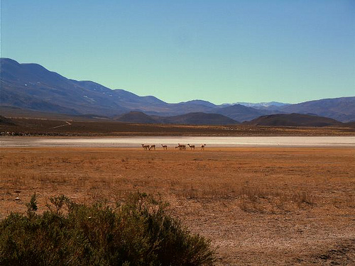
Laguna Blanca National Park (Parque Nacional Laguna Blanca) occupies about 11,250 hectares (112.5 km²) in the western part of Neuquén Province, northern Patagonia, Argentina, roughly 30 km west of the town of Zapala. It lies near coordinates 39°02′S, 70°21–24′W, at elevations around 1,270 m above sea level, within the Patagonian steppe ecoregion. Created in 1940 (formalized later) primarily to protect the lagoon and its black-necked swan population, it was designated a Ramsar wetland of international importance in 1992. The protected area includes both a national park and a national reserve portion.
Best Time to Visit
Spring and summer (roughly November–March) are
ideal for hiking, birdwatching, photography, and enjoying milder
conditions with longer daylight. Birds are most active and visible from
about October to March. Autumn and winter (April–October) are better for
recreational fishing and quieter visits, though snow, stronger winds, or
limited access can occur—always check the National Meteorological
Service (smn.gob.ar) and road conditions in advance. The climate is arid
and windy with large daily temperature swings; mean annual temperature
is around 10°C, with summer highs that can exceed 30–40°C and winter
lows dropping well below freezing. Elevation is around 1,280 m.
Getting There and Access
The park is best reached by car. From
Neuquén city it is about 215 km west via RN 22 to Zapala, then RN 40 and
RP 46 (paved approach). From Zapala it is roughly 36 km. Other
approaches include from San Martín de los Andes/Junín de los Andes
(longer, check alternative routes), or via border passes such as Pino
Hachado or Icalma from Chile. Airports: Neuquén (NQN, ~212 km) or
Chapelco (CPC, ~237 km). Public transport options are limited—buses run
to Zapala, after which a taxi or the daily Aluminé-bound buses (ask to
be dropped at the park turnoff) can work, but services are infrequent;
confirm schedules. There is no direct public transport to the entrance
in most cases. Fill up on fuel, food, and water in Zapala. Check
national and provincial road status before departure, especially in
winter.
The park is open daily during daylight hours. Approximate
hours: winter (1 April–31 October) 9:00–19:00; summer (1 November–31
March) roughly 8:00/9:00–20:00. Only registered campers may stay
overnight. The Centro de Visitantes Nómades is the main hub (services
typically available during open hours).
Key Activities and Trails
Birdwatching: A highlight. Expect black-necked swans (a park emblem and
important nesting site), Austral flamingos, shorebirds, coots, raptors
such as the common hawk and peregrine falcon, rheas (choiques), and
condors. Use binoculars, a field notebook, and a checklist. Best from
October–March. Observatories and the lagoon shore are excellent vantage
points.
Easy family trails:
Paseo de la Laguna: ~700 m round-trip,
low difficulty. Starts at the visitor center with interpretive stops on
flora and fauna; ends at a bird observatory with lagoon views. Do not
move or remove stones (important microhabitats).
Sendero geológico El
Escorial: ~680 m round-trip (~50 minutes), low difficulty. Follows
volcanic cones and lava fields (escoriales) with geological
interpretation. There is a small viewpoint and parking near the RP 46
entrance from Zapala.
More challenging:
Cerro Mellizo Sur:
~3.5 km round-trip (~4 hours), medium to medium-high difficulty. Reaches
~1,723 m with panoramic views of the lagoon, park, nearby settlements,
and Zapala. Crosses escoriales and steppe vegetation; possible sightings
of chinchillas, rheas, and foxes. Register at the visitor center before
starting. The upper section has a steeper incline.
Other options
include lagoon-shore walks for picnics (bring shade, chairs, mate, and
water—no swimming or water sports allowed due to ecosystem fragility and
lack of lifeguards) and visits to archaeological rock shelters (aleros)
formed by volcanic flows. Respect cultural sites: do not disturb rocks,
paintings, or artifacts, and report any finds to rangers.
Recreational fishing is allowed from 1 April to 31 October for rainbow
trout and perch (fly casting, spinning, etc.). A provincial permit is
required; fishing also supports ecological management of introduced
fish. No navigation or extensive aquatic recreation is permitted on
Laguna Blanca.
Camping, Picnic, and Facilities
The free El
Chimango camping/picnic area (about 2 km from the visitor center on RP
46) has tables, benches, and fire pits for daytime use, plus limited
tent sites and motorhome spots. Bring your own potable water (lagoon
water is brackish and not drinkable), food, and firewood or
charcoal—firewood collection is prohibited. Use a stove if possible.
Bathrooms and services are at the visitor center (typically 9:00–19:00).
No electricity or shop on site. Camping requires mandatory registration
and depends on weather; fires only in designated areas. Pack out all
trash. Zapala (36 km) has hotels, hostels, restaurants, fuel, and
supplies.
Practical Tips and Rules
Gear: Layered clothing
(onion-style) for wind and temperature changes, comfortable walking
shoes, hat, sunscreen, light windproof/rain jacket, insect repellent,
binoculars, and at least 2 liters of water per person. Paper map
recommended; cell/Wi-Fi signal is often absent.
Conservation: Stay on
marked trails and roads; use designated parking. Do not remove stones
(protects habitats for the endemic frog, arachnids, and other species).
No hunting. Pets are discouraged or must be controlled/leashed—check
current rules. Drive slowly to avoid wildlife. Leave no trace.
Safety: Strong winds are common and can be intense; secure tents well.
High UV and open skies mean sun protection is essential. Register for
longer trails and camping. Check trail status and weather alerts.
Altitude and aridity require hydration and preparation.
Wildlife
note: The park is a key refuge for the critically endangered Patagonian
frog, endemic to the region and once more widespread in the main lagoon
(impacted by introduced fish). Protect wetlands and microhabitats. Other
herpetofauna and steppe mammals are present.
Contact the park
intendancy in Zapala (Calle 12 de Julio 686; phone roughly (02942)
431982; email lagunablanca@apn.gob.ar) for current trail conditions,
fishing rules, or updates. Official Argentina.gob.ar pages for the park
are the primary reference for regulations, maps, and PDFs on trails and
flora.
The Lagoon and Hydrology
The park’s defining feature is Laguna
Blanca, an endorheic (closed-basin) freshwater to alkaline lagoon of
roughly 1,700 hectares. It sits at about 1,270–1,280 m elevation,
reaches a maximum depth of around 9–12 m (commonly cited near 10 m), and
has about 30 km of shoreline, with maximum dimensions on the order of 6
km long by 4 km wide. Two temporary, low-flow streams—Arroyo Llano
Blanco and Arroyo Pichi-Ñireco—feed it; these can carry sediment from
surrounding eroded soils and become turbid. The lagoon represents the
largest endorheic basin in the basaltic region of western Neuquén and
serves as a major freshwater reservoir in an otherwise arid landscape.
In recent years its volume has declined during periods of lower
precipitation.
Smaller lagoons and ponds (such as Verde, Jabón,
Antonio, del Molle, and del Hoyo) occur within or near the park
boundaries and provide additional wetland habitat. The water body
supports high concentrations of aquatic birds and historically hosted
significant populations of the endemic Patagonian frog (Atelognathus
patagonicus), though the main lagoon population was largely lost after
the introduction of predatory fish; the species persists in some
isolated smaller ponds.
Geology and Landforms
The landscape is
strongly volcanic and relatively youthful in places. The lagoon is
framed by ancient monogenetic volcanic cones and basaltic hills with
gentle slopes and abrupt scarps or “bardas.” Prominent features include
Cerro de La Laguna (on the northwestern/northern margin, linked to
Holocene Basalto Laguna Blanca olivine basalt flows) and Cerro Mellizo
Sur / Los Mellizos Sur (southeastern side, associated with Pleistocene
Basalto Los Mellizos). These and related centers produced pahoehoe-type
lava flows, inflated sheet flows, lava rises, tumuli, and basaltic
escoriales (lava fields), especially toward the south. The rocks are
predominantly olivine basalts of Pleistocene–Holocene age, part of
broader back-arc volcanic activity associated with the southern Loncopué
graben region.
The terrain consists of volcanic plateaus, rocky
hills, gorges, and open steppe plains with volcanic, sandy, and stony
soils. This creates a striking contrast between the dark basaltic rocks,
the pale or blue-tinged lagoon surface, and the sparse vegetation. The
setting preserves both the wetland and representative terrestrial steppe
environments.
Climate
The climate is arid to semi-arid and
strongly windy, dominated by dry westerlies. Diurnal temperature ranges
are large. Summer mean temperatures are about 22 °C, with heat-wave
peaks that can exceed 40 °C. Winter means are near 5 °C, with extremes
down to −20 °C. Annual precipitation is low (typically 150–200 mm),
concentrated in the winter half-year, accompanied by significant
snowfalls. Strong winds and the lack of shade are characteristic
year-round. The most comfortable visiting season is generally November
to March.
Vegetation and Wildlife (Biogeographic Context)
Steppe vegetation is low-growing and highly adapted to wind, winter
snow, and summer drought: plants tend to be short, often spiny or
thorny, and deep-rooted. Dominant communities include shrublands with
species such as duraznillo, neneo (Mulinum spinosum), and molle, plus
extensive coirón grasslands (tussock-forming grasses, typically Festuca
species, that form compact yellowish mats). Wetter margins and stream
edges support more developed grasses and hydrophytic plants. Overall
cover is sparse, leaving much bare or rocky ground.
The park is best
known for its aquatic bird concentrations. The black-necked swan (Cygnus
melancoryphus) is the emblematic species; other frequent visitors and
residents include flamingos, silvery grebes, coots, various ducks,
shorebirds, and more than a hundred bird species that use the lagoons
seasonally. Cliffs and rocky walls host nesting raptors (including
common hawks and peregrine falcons). Terrestrial fauna includes pumas,
foxes, mountain viscachas (chinchillones), lesser rheas (choiques),
armadillos, and Andean condors overhead. The combination of the open
lagoon, volcanic steppe, and rocky relief creates distinct habitats that
support this mix of wetland and arid-land species.
Additional
Notes
Near the lagoon lies Salamanca Cave, which contains rock
paintings typical of northern Patagonia along with other Mapuche and
prehistoric archaeological traces, reflecting long human use of the area
for seasonal pasturing and earlier occupation. The park’s relatively
small size and accessible location near Zapala (via Ruta Nacional 40 and
Ruta Provincial 46) make it a focused example of Patagonian steppe
wetland conservation within a volcanic setting.