Location: 3 km from Villa la Angostura, Neuquén Province Map
Area: 17.53 km2
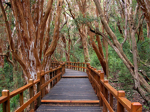
Los Arrayanes National Park (Parque Nacional Los Arrayanes) protects a rare, dense stand of arrayán (myrtle, Luma apiculata) trees on the Quetrihué Peninsula, which juts into Lake Nahuel Huapi near Villa La Angostura in Neuquén Province, northern Patagonia. Created in 1971, the park covers only about 1,796 hectares and forms part of the larger Nahuel Huapi system and the Andino Norpatagónica Biosphere Reserve. The trees feature smooth, cinnamon-to-orange peeling bark, can reach significant heights and ages (some centuries old, with claims of specimens over 600 years), and produce white flowers mainly from December to March. A popular local legend holds that the forest inspired Walt Disney’s Bambi.
Ways to Visit
Access is only from the northern
isthmus (near Villa La Angostura) by land or by boat to ports including
Quetrihué (near the forest).
Boat (easiest and most popular for
limited time): Catamarans such as Futaleufú depart from Bahía Mansa in
Villa La Angostura. The crossing takes roughly 40–50 minutes with lake
and mountain views. Typical visits include a short guided walk on the
boardwalks (around 30–45 minutes) plus free time at the tea house.
Round-trip excursions last about 3 hours. One-way tickets allow
combinations with hiking or biking. From Bariloche, longer lake trips
from Puerto Pañuelo often combine the forest with Isla Victoria.
Hiking: The main trail is about 11–12 km one way (medium difficulty,
roughly 3 hours at a normal pace; 22–24 km round trip for 6–8 hours). It
starts at the isthmus between Bahía Mansa and Bahía Brava, passes
through coihue and other native forest, includes viewpoints (e.g.,
Mirador Messidor looking toward the town and bays, Mirador Brazo Norte),
and ends at the elevated wooden boardwalks through the densest arrayán
stand. Markers appear regularly. The initial section has a notable
climb; the rest is more moderate with rolling terrain. Some hikers note
particularly impressive arrayanes just before the official boardwalks.
Mountain biking: Allowed on the trail, with helmets required. Expect to
carry the bike on steeper or technical sections (especially the early
climb). Round-trip by bike is faster than walking (often cited around 3
hours total).
Recommended combo: Boat one way and hike (or bike) the
other. Many prefer arriving by boat and hiking back for more flexible
timing and to avoid rushing for a return boat. You must hold a valid
return boat ticket before starting a land leg if returning by water, and
respect strict last-entry times.
No camping is allowed; it is a
day-use area only.
Hours and Entry Rules
Official last-entry
times vary by season and activity (summer roughly 1 November–15 March;
winter 16 March–31 October). Examples from official guidance:
Summer:
Walking round-trip until about 14:00; biking round-trip until 15:00;
walking + boat return until 15:00; biking + boat until 16:00.
Winter:
Earlier cutoffs (e.g., walking round-trip until about 11:00).
Proof of a boat ticket is required for mixed itineraries. Confirm
current rules, as they can be adjusted. The park is open year-round, but
winter brings shorter days, colder weather, and possible snow or mud on
the trail, making the boat preferable for many.
Fees
(approximate, as of mid-2026 updates)
Entry is charged (paid at the
access or included/added for boat trips). Recent rates for Los Arrayanes
(aligned with Nahuel Huapi and similar parks):
General
(non-residents/foreigners): around ARS 35,000
Argentine national
residents: around ARS 15,000
Provincial residents (Neuquén/Río
Negro): around ARS 8,000
Students: around ARS 12,000
Free or
reduced for children under 5, Argentine pensioners, people with
disabilities, and certain local residents or educational groups. Boat
prices are separate (recent examples around ARS 60,000–75,000 for
one-way or round-trip segments on local catamarans; Bariloche combined
trips cost more). Always verify current fees and schedules, as they
change.
Best Time to Visit
November to April offers the most
favorable conditions: longer daylight, milder temperatures (summer highs
often in the mid-teens to mid-20s °C), and better trail access. Peak
summer brings more crowds and higher prices. Spring and early autumn can
be quieter with good light for photography; autumn adds color in the
surrounding forest. Winter is colder and wetter with possible snow,
limiting land options. Arrayán flowering peaks in summer. Patagonian
weather is changeable—prepare for sun, wind, and rain in the same day.
Practical Tips
Logistics from Villa La Angostura: The
entrance/port area is a short drive, taxi, or local bus ride from the
center. Parking is available at the isthmus. From Bariloche (~83 km /
1–1.5 hours by road via RN40/RN231) or along the scenic Seven Lakes
Route from San Martín de los Andes, arrive by bus, rental car, or
transfer. International flights land in Bariloche.
What to bring:
Sturdy walking shoes, layers (including a light jacket or rain shell),
water and snacks (especially for the full hike), sunscreen, hat, and
sunglasses. The sun can be strong at altitude/latitude even on cooler
days. Cash or cards as needed for fees, boats, and the tea house.
On
site: Stay strictly on the wooden boardwalks in the arrayán forest to
protect the shallow, sensitive root systems. Facilities include
bathrooms at the main access, dry toilets, and a historic tea house
(“Casita de Bambi” or similar, dating to the 1930s) offering drinks,
sandwiches, and cakes. Viewpoints reward the hike. Wildlife is modest
but can include birds and occasional native mammals; the flora mixes
arrayanes with coihues, cypresses, ñires, and understory plants.
Crowds and timing: Early boats or early trail starts help avoid peak
groups. The boardwalk section sees the most concentration when boats
arrive. Photographers favor softer morning or late light.
Reservations and planning: Book popular catamaran departures ahead in
high season. Check weather, trail conditions, and exact boat times the
day before. Allow a full day if combining the hike with the boat or
exploring Villa La Angostura. Pair the visit with the Seven Lakes Route,
nearby beaches (Bahía Mansa/Brava), or other short hikes.
Regulations
and safety: No overnight stays. Follow ranger instructions. The trail is
well marked but requires reasonable fitness for the full distance; turn
around if needed to meet cutoff times. Mobile coverage is limited in
places.
Location and Setting
The park occupies the entire Quetrihué
Peninsula, a narrow landform that extends southward into the northern
arm of Lake Nahuel Huapi (Lago Nahuel Huapi). Coordinates are
approximately 40°50′S, 71°37′W. It lies only about 3 km from the town of
Villa La Angostura and is administratively linked to the much larger
Nahuel Huapi National Park, from which it was separated in 1971.
Together they form part of the Andino Norpatagónica Biosphere Reserve
(designated 2007) and the Patagonian Andean forest ecoregion.
The
peninsula connects to the mainland by a narrow northern isthmus near
Villa La Angostura. Its southern tip holds the park’s defining feature:
a pure stand of arrayán forest covering about 20 hectares. Two small
lagoons in the peninsula’s interior—Hua-Huan and Patagua—connect to Lake
Nahuel Huapi and support specialized wetland habitats.
Elevation
ranges roughly from 760 to 1,000 meters above sea level. The surrounding
landscape is dominated by the glacial Lake Nahuel Huapi and the Andean
cordillera rising to the west, creating a classic Patagonian
lake-and-mountain setting.
Geological and Physical Geography
The terrain is the product of Pleistocene glaciation. Retreating ice
carved U-shaped valleys, deposited moraines, and left the deep basin now
filled by Lake Nahuel Huapi. The peninsula itself rests on volcanic and
ancient metamorphic rocks of the Andes; volcanic soils help create the
moist, well-drained conditions favored by the arrayanes.
The
topography is gently hilly, with the main 12 km trail from the isthmus
to the southern forest featuring repeated ups and downs. Strong
prevailing westerly winds and proximity to the large lake moderate
temperatures slightly compared with more exposed Andean slopes.
Climate
The climate is cold and humid, typical of the
Andean-Patagonian transition zone, only mildly tempered by the lake.
Mean temperatures range from about 3 °C (37 °F) in winter to 14 °C (57
°F) in summer. Annual precipitation is commonly cited around 1,300 mm
(some sources note closer to 2,000 mm closer to the cordillera), falling
mostly in winter. Snow is frequent from July to September. The best
period for hiking and boat access is late spring through early autumn
(roughly January–March), when days are cool, relatively dry, and clear.
Ecosystems and Vegetation
The park preserves a representative
sample of the Patagonian Andean forest (bosque andino-patagónico). Its
ecological centerpiece is the nearly pure forest of southern arrayán
(Luma apiculata, Myrtaceae family), also known in Mapudungun as quetri.
These evergreen, slow-growing trees typically reach 8–15 meters
(occasionally taller), with twisted, cinnamon-to-golden bark that peels
in thin sheets to reveal smooth white patches underneath. Many
individuals are 300–600 years old or more; some reports suggest
lifespans approaching 650 years. The pure stand at the southern tip is
one of the finest and most extensive of its kind and is rare worldwide.
Around the arrayanes and along the peninsula grow coihue (Nothofagus
dombeyi), ñire (N. antarctica), cordillera cypress (Austrocedrus
chilensis), radal, maitén, patagua, hua-huan, and notro. The understory
includes maqui, colihue cane, canelo, and, in wetter spots, pangue
(Gunnera) and chilco (Fuchsia). Small peat bogs (turberas) appear in
places. A wooden boardwalk system protects the shallow, sensitive root
systems of the arrayanes from compaction.
Fauna
Mammal
presence is limited by the park’s small size but includes the pudú (one
of the world’s smallest deer), occasional huemul, guanaco, monito de
monte (a small marsupial), culpeo fox, huiña cat, and the endangered
southern river otter (huillín, Lontra provocax), recorded especially
around the internal lagoons. Birdlife is richer: Andean condors, various
eagles and hawks, Magellanic and other woodpeckers, chucao, the
southernmost parrot (cachaña), and imperial cormorants that nest on
nearby islands.
Conservation Context
Created by Law 19.292 on
11 October 1971 specifically to protect the rare pure arrayán forest,
the park had previously been part of Nahuel Huapi National Park (itself
descending from Latin America’s first national park, established in
1922). Strict visitor controls, boardwalks, and seasonal entry rules
(earlier closing times in winter) limit impact on the fragile soils and
slow-growing trees. The park is managed by Argentina’s Administración de
Parques Nacionales, with administrative headquarters shared with Nahuel
Huapi in San Carlos de Bariloche.