Location: 159 mi (256 km) West of Puerto Peseado Map
Open: 8am- 6pm daily
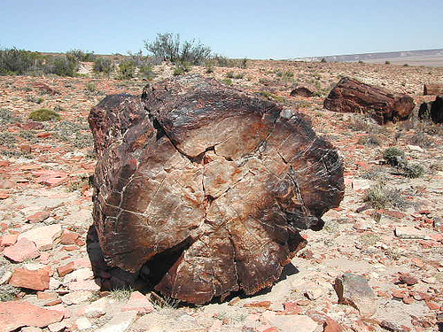
Monumento Natural Bosques Petrificados de Jaramillo is a natural park that protects fossils of the ancient petrified forest located 159 mi (256 km) West of Puerto Peseado in Argentina. Monumento Natural Bosques Petrificados de Jaramillo or Petrified Forest Natural Monument in the North- East Santa Cruz Province of Argentina is a natural formation of fossilized ancient forest. It cover a total area of 13,70 hectares (34,000 acres). Semi desert area is littered with remnants of the ancient forest dating back 150 million years ago during the late Jurassic period of the Mesozoic Era when the area was frequented by massive dinosaurs. Much of the area at the time was covered by evergreen conifer trees of now extinct Araucaria mirabilis. Volcanic activity of the Andes mountains covered ancient forest with ash and lava. This offered a great chance for petrifications of ancient trees and its cones in a perfect time capsule. Some of the fossils discovered in the area were measured at 100 m (328 feet) in height with a diameter of 3.5 m (11 feet). Apparently Patagonia and area of Monumento Natural Bosques Petrificados de Jaramillo during the Jurassic peiod enjoyed much wetter and warmer climate than today.
Getting There
Access is via Ruta Nacional 3 to roughly km 2074,
then Ruta Provincial 49 (gravel/ripio) for about 50 km to the ranger
station and entrance.
Approximate distances:
Comodoro
Rivadavia (Chubut): ~290–320 km
Puerto Deseado: ~250 km
Puerto San
Julián: ~230–250 km
Caleta Olivia: ~217–234 km
Fitz Roy /
Jaramillo: closer points on the approach
There is no direct
public transport. Most visitors rent a car (from Comodoro Rivadavia or
Puerto Deseado) or join an organized excursion. The final 50 km is
gravel; drive carefully due to animals on the road, possible loose
surfaces, frost in winter, or mud after heavy rain. A higher-clearance
vehicle is preferable, though many ordinary cars manage it in dry
conditions. Fill the tank completely before the gravel section—nearest
fuel is around Fitz Roy (~140 km from the north) or Tres Cerros (~90 km
from the south). No fuel is available at the park.
Hours, Fees,
and Facilities
Entrance: Free.
Hours: High season (roughly 1
October–31 March): 9:00–19:00. Low season (1 April–30 September):
10:00–17:00. Open year-round, but always check current conditions.
Facilities are minimal: ranger station, small interpretive museum (Museo
Guardaparque Peter Garrahan) explaining the petrification process and
local ecology, public toilets, and picnic tables. No food, water,
lodging, or camping inside the park. Pack out all trash.
Register
with the rangers on arrival. Guided walks are sometimes available;
otherwise the main trail is self-guided with interpretive signage.
Main Attractions and Trails
Sendero Paleontológico
(Paleontological Trail): The highlight. Approximately 2 km, low
difficulty, 45–90 minutes. It winds among the giant fallen petrified
araucaria trunks lying on the steppe. Many retain clear wood grain and
structure. Excellent views of Cerro Madre e Hija. Suitable for most ages
and fitness levels; bring water and sun protection.
Cerro Madre e
Hija / Volcán Madre e Hija: A longer, moderate option (roughly 5–9 km
round trip or similar, 2.5–3 hours depending on exact route). Accessed
via a detour off RP 49. Register at the operational center; in low
season there is often a midday cutoff for starting (around noon). Rocky,
little shade, strong winds possible. Rewarding for the volcanic
landscape.
Additional short viewpoints and the surrounding steppe.
Nearby on the approach (Fitz Roy area) is the free “Era de Hielo”
archaeological site with replicas of a glyptodont and giant sloth under
a protective dome.
Wildlife you may see includes guanacos, gray
foxes, lesser rheas (choiques), armadillos (piches), various birds, and
lizards. Steppe vegetation includes low shrubs, coirones, and calafates.
Best Time to Visit
October–March (spring through summer) is
strongly preferred: milder temperatures, longer days, better road
conditions, and more comfortable walking. Summer days can still be hot
and extremely windy; nights are cool.
Winter (especially June–August)
brings extreme cold, strong winds (sometimes >140 km/h), possible snow
or ice, and potentially restricted access. The park remains open, but
conditions can be harsh and some trails or roads more difficult.
Essential Visiting Tips
Self-sufficiency is mandatory: Bring plenty
of drinking water, food, snacks, and a full fuel tank. There are no
services on site.
Clothing and protection: Layered clothing for wind
and temperature swings. Hat, sunscreen, sunglasses, and lip balm (UV is
strong). Comfortable closed walking shoes with good grip. A light jacket
is useful even in summer.
No signal: Mobile coverage is essentially
nonexistent. Download offline maps, carry a physical map or GPS, and
tell someone your itinerary.
Rules: Do not remove fossils, rocks, or
plants. Stay on marked trails. No camping or fires in the park. Pets are
generally not permitted. Respect wildlife and speed limits on roads.
Pack out trash.
Camping and lodging: No camping inside the park.
Private camping is available at Estancia La Paloma (about 20 km before
the entrance on RP 49). Towns such as Puerto Deseado, Caleta Olivia,
Fitz Roy, or Jaramillo offer hotels, guesthouses, and restaurants.
Safety: The area is remote and isolated. Carry a basic first-aid kit. Be
cautious of wind, sun exposure, and animals on the road. Inform rangers
of your plans, especially for the longer Cerro trail.
Duration: One
full day is sufficient for the main trail and museum. Allow extra time
for the gravel road and potential stops. It pairs well with Puerto
Deseado or other Patagonian destinations on a multi-day itinerary.
Contact: bosquespetrificados@apn.gob.ar or phone +54 297 483 1201
(intendencia in Caleta Olivia). Check the official Administración de
Parques Nacionales site or recent visitor reports for current road and
trail status before traveling.
Location and Regional Setting
The park lies on the Meseta Central
santacruceña (Central Santa Cruz Plateau), specifically within the
Macizo del Deseado (Deseado Massif or Nesocratón del Deseado). This is a
stable, positive structural block that has behaved as a relatively
rigid, elevated area through much of its geological history, bounded
roughly by the Deseado and Chico rivers. It stretches from the Atlantic
coast eastward influences to the Pinturas River area westward.
Approximate coordinates for the paleontological core are around
47°41′36.56″ S, 68°03′57.76″ W (or broadly 47°40′ S, 68°10′ W).
Nearest settlements include Jaramillo and Fitz Roy (~140 km north of the
main site). Access is primarily from Ruta Nacional 3 at km 2074, then
~39–50 km of gravel Ruta Provincial 49 to the park entrance and
operational center. It is remote, with limited services; fuel and
supplies are obtained in places like Fitz Roy or Tres Cerros.
Climate
The climate is cold, arid (semi-arid steppe), and extremely
windy, with large diurnal temperature ranges. Mean temperatures are
about 19°C in summer (maxima up to 40°C) and 7°C in winter (minima to
–15°C). Annual precipitation is low, typically under 200–400 mm,
concentrated in winter as rain or snow. Strong westerly winds average
around 70 km/h, with frequent gusts exceeding 140 km/h. These conditions
produce dry summers, frequent frosts year-round, and high solar
exposure. The ideal visiting season is spring and summer.
This
aridity results from the rain-shadow effect of the Andes: moisture from
the Pacific is largely blocked, and remaining air dries further as it
crosses the plateau.
Geology and Paleogeography
The park is
one of Argentina’s premier paleontological and geological sites,
preserving a Middle–Late Jurassic (~150–170 million years ago) forest
buried by volcanic activity.
Tectonic and stratigraphic context:
The Macizo del Deseado is a stable cratonic block contrasting with the
neighboring subsiding Golfo San Jorge and Austral basins. The oldest
exposed unit in the park is the Middle Jurassic Formación Bajo Pobre
(~170 Ma): dark volcanic and pyroclastic rocks (andesites, basalts,
agglomerates) linked to continental rifting associated with the breakup
of Gondwana and the opening of the South Atlantic.
Grupo Bahía Laura
(Middle–Late Jurassic, ~165–155 Ma): Dominated by explosive volcanism.
The Formación La Matilde (acidic tuffs and related sediments) hosts the
main petrified forest. It was deposited in a low-energy continental
fluvial–palustrine–lagoonal environment amid intense distal volcanism.
Ash falls buried forests of conifers (primarily Araucaria mirabilis,
related to modern monkey-puzzle trees/pehuenes), along with pines,
ferns, cycads, and extinct bennettitaleans. Silica-rich ash facilitated
permineralization (petrification), preserving trunks (some >30–35 m long
and up to 3 m in diameter), cones, and fine anatomical details,
including embryos. Trees were often mature (centuries old) when buried.
Multiple forest levels (e.g., Barda Blanca and Bosque Principal) are
separated by lagoonal deposits with equisetales.
Later units:
Cretaceous Formación Baqueró (volcanic-sedimentary, rich in fossil
flora, with organ-pipe erosion on cliffs); basaltic flows (including Las
Mercedes and later Cenozoic basalts showing relief inversion); Miocene
volcanic remnants. The landscape also records Oligocene–Miocene marine
incursions (Formación Monte León) in limited outcrops.
The rise
of the Andes transformed the climate from warm and humid (pre-Andean
forest) to the current arid steppe. Erosion later exposed the silicified
trunks, many of which remain in situ or partially upright. The site is
internationally recognized for the quality of Araucaria mirabilis
preservation.
Landscape, Geomorphology, and Key Features
The
present landscape is dominated by arid Patagonian steppe: low, irregular
relief of rounded hills, basaltic mesetas with steep slopes from mass
wasting, isolated peaks, and extensive plains. Fluvial erosion
(ephemeral streams), wind, and volcanic landforms shape the terrain. Two
main landscape types appear: basaltic plateaus and lower irregular
relief with rocky outcrops.
Cerro Madre e Hija: The dominant
landmark, a highly eroded Miocene volcanic cone (~18 Ma, ~400–405 m
above sea level—the highest point in the protected area). Its twin-like
peaks are visible from the paleontological site and symbolize the park.
It rises above the Laguna Grande valley.
Petrified forest exposures:
Concentrations of massive silicified trunks and cones on the steppe
surface, especially along the ~2 km paleontological trail. Colors range
from reddish-brown to gray; textures preserve bark and wood grain.
Lagoons and depressions: Laguna Grande and smaller bodies (e.g., El
Baldío) occupy basins with playa deposits, former shorelines, and fine
sediments (guadales/barreales). These are often temporary.
Soils and
surface: Rocky, sandy, and gravelly with sparse vegetation; volcanic
ashes and basaltic debris are common. Erosion exposes paleosols
associated with the fossil forests.
Hydrology and Soils
Surface water is scarce and mostly ephemeral. Cañadones (dry valleys)
carry intermittent flows after rains. Springs and small wetlands support
localized moisture. Basaltic lavas promote infiltration and edge seeps.
Soils are generally thin, poorly developed, alkaline to neutral in
places, and adapted to drought and wind.
Current Biogeography
The ecoregion is classic Patagonian steppe: sparse, low shrubs and
bunchgrasses (coirones such as Stipa, Poa, Festuca), cushion plants,
cacti, and Asteraceae. Sheltered cañadones support denser shrubs (molle,
duraznillo, calafate). Wildlife includes guanacos, gray and culpeo
foxes, lesser rheas (choiques), various birds (chingolos, agachonas),
and lizards. Microhabitats (springs, temporary lagoons, rocky areas)
increase local diversity. The park conserves representative steppe
processes and associated species alongside the fossils.