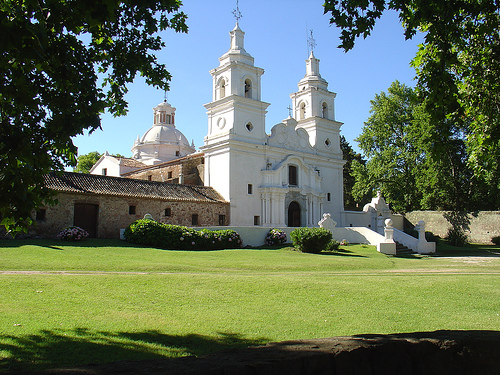
Location: 13 mi (20 km) North of Jesus Maria, Córdoba
Tel. (03525) 421 600
Open:
Jan- Feb 10am- 1pm & 3pm- 5pm Tue- Sun
Mar- Dec 10am- 1pm & 2pm- 6pm Tue- Sun
Service: Apr- Sep 10am- 1pm Tue- Sun
Oct- Mar 10am- 1pm & 3pm- 7pm Tue- Sun
Santa Catalina (Jujuy Province, northwestern Argentina) is one of
the country’s northernmost permanent settlements—second only to
nearby El Angosto—and a quiet, high-altitude outpost in the Puna
(Andean plateau) roughly 3 km from the Bolivian border.
At about
3,802 m (12,474 ft), it offers colonial architecture, traditional
adobe buildings, stark highland landscapes, and a base for exploring
remote villages, border areas, and the Laguna de los Pozuelos
region. It is isolated, basic in services, and rewards travelers
seeking authenticity over comfort.
Location and Geography
Santa Catalina sits in the
Department of Santa Catalina in extreme northern Jujuy, in the arid,
sparsely populated Puna. The Santa Catalina River runs beside the
compact town. Days are bright and dry with intense UV; nights drop
sharply due to altitude and low humidity. The landscape features
highland steppe, distant mountains, and valleys such as Quichagua.
Brief History
The area has been inhabited for millennia by
indigenous groups who hunted, gathered, farmed, and herded camelids. The
Inca incorporated the region around 1470; Spanish arrival from about
1535 brought gold mining (both hard-rock and alluvial). The settlement
grew around the church in the 17th–18th centuries on lands linked to the
Marquises of Tojo (based in Yavi). It served as a regional trade node.
An indigenous uprising in the 1870s related to land tenure was
suppressed. The arrival of the railway at La Quiaca (founded 1907)
reduced its commercial importance. Some accounts cite a 1547
mining-related origin.
Getting There
The main access is from
La Quiaca (~63–67 km east) via Provincial Route 5, mostly gravel
(ripio). The drive takes roughly 1–1.5 hours depending on conditions.
From the south, connect via Ruta 40 near Oratorio onto RP 65 (~21 km).
From San Salvador de Jujuy it is a longer journey (about 5–6 hours) via
National Route 9 to La Quiaca then RP 5.
Public transport consists of
occasional buses or combis from La Quiaca on certain days. A private
vehicle or arranged 4x4 is far more practical, especially for
surroundings. There is no fuel in Santa Catalina—fill up in La Quiaca or
larger towns. Roads can deteriorate or wash out in the rainy season
(roughly November–April); check conditions and drive cautiously on
gravel, mountain, and solitary routes. A capable vehicle and driver
experienced with high-altitude and ripio roads are advisable.
Best Time to Visit and Weather
The dry season (roughly
April–November) is preferable for road reliability. Spring
(September–November) and autumn (March–May) offer milder conditions.
Winter is cold, sunny, and dry but nights are very cold. Summer brings
more rain and potential road issues.
Expect large diurnal swings (up
to ~30°C / 54°F difference). Average summer highs are modest (around
18–20°C / 64–68°F); winter lows commonly reach –5°C (23°F) or lower,
with extremes possible near –15°C (5°F). Frost can occur any time of
year. The air is dry; UV is intense. Layer clothing and always pack warm
layers, even in the warmer months.
What to See and Do
The town
itself is small and walkable in a short circuit around Plaza San Martín.
Iglesia de Santa Catalina de Alejandría: The main colonial landmark
(17th century). It features a distinctive three-story telescopic tower
about 10 m high and as wide as the nave; the nave is roughly 32 m long.
Historic bells (some dating to the 16th century) and colonial-era images
are highlights. It stands on the south side of the plaza next to the old
Saravia family house. Opening depends on local schedules and festivals.
Museo Privado Regional Epifanio Saravia and traditional adobe
architecture.
Viewpoint along RP 5 overlooking the town, church,
plaza, and river.
Quiet streets, local life, and occasional Andean
traditions or festivals (e.g., Virgen de Chinchillas celebrations around
15 August with processions and sikuri dances).
Nearby and day
trips (vehicle or guided recommended; gravel and remote tracks):
El
Angosto (northernmost Argentine settlement, ~45 km).
La Ciénaga
(notable zigzag descent).
Piscuno (border marker runs through the
settlement), Casira (pottery village), El Morrito petroglifos
(prehispanic rock art—do not disturb).
Quebrada de Cabrerías and
other Puna villages.
Monumento Natural Laguna de los Pozuelos
(Biosphere Reserve / Ramsar site): Important for flamingos (including
Andean and James’s) and other highland birds. Accessible via gravel
routes from the area (distances vary by exact route; roughly 80–90+ km
depending on path). Free entry; birdwatching and short walks possible.
Conditions and water levels vary seasonally.
Activities also
include short hikes, birdwatching, photography of landscapes and
architecture, and (with proper arrangements) horseback or longer 4x4
circuits. Guided operators familiar with the NOA (e.g., regional
specialists such as Norte Trekking) can arrange multi-day trips.
Accommodation and Food
Options are limited and basic. Hostal Don
Clemente (near the entrance) is the best-known: family-run, rooms with
private or shared baths, heating, hot water, home-cooked meals
(breakfast and dinner available), and WiFi for guests—valuable given the
lack of cell signal. It occupies a traditional building and offers a
local atmosphere. Other basic municipal or simple lodging may exist;
availability is limited, so inquire ahead or via La Quiaca.
Food is
simple and regional where available (llama, Andean potatoes, home-style
dishes at the hostal). Bring snacks, water, and supplies; shops are
limited. Cash (Argentine pesos) is essential—ATMs are absent or
unreliable locally.
Practical Tips
Altitude: At ~3,800 m,
altitude sickness (apunamiento/soroche) is a real risk. Acclimatize
gradually (spend time at intermediate elevations such as La Quiaca or
Abra Pampa first), stay hydrated, move slowly at first, eat light meals,
and consider traditional coca tea. Avoid alcohol and heavy exertion on
arrival. Consult a doctor beforehand if you have health conditions.
Packing: Layers, warm jacket/fleece, hat, gloves, sturdy shoes,
sunglasses, high-SPF sunscreen, lip balm, headlamp, and basic
medications. Nights are cold year-round.
Connectivity and services:
No cell signal in town. Limited WiFi at some lodging. Police, a health
post, and municipal office exist but services are basic. Electricity and
water can be intermittent in remote areas.
Money and supplies: Carry
sufficient cash. Fuel, groceries, and more services are in La Quiaca.
Safety and driving: The area is generally quiet and low-crime, but
remote. Inform someone of your plans. Drive slowly on gravel, watch for
animals and washouts, and carry water, extra food, and warm gear in case
of delays. Respect indigenous communities, archaeological sites (look
but do not touch or remove anything), and local customs.
Language:
Spanish (with Andean/Quechua influences); English is uncommon.
Origins and Jesuit Acquisition (16th–17th centuries)
The lands in
the area known as Calabalumba la Vieja were granted in 1584 as a merced
(royal land grant) to Miguel de Ardiles, a companion of Jerónimo Luis de
Cabrera, founder of Córdoba in 1573. They later passed to the blacksmith
Luis Frassón (also linked to Cabrera’s expedition). On 1 August 1622,
the Society of Jesus bought the property from Frassón for 4,500 pesos,
including rudimentary buildings and substantial livestock.
The
purchase was strategic. The Jesuits had established themselves in
Córdoba in 1599, founded a novitiate (1608), and created the Colegio
Máximo (the seed of the future University of Córdoba). The estancias
were productive enterprises meant to finance education, missions, and
religious work across the Jesuit Province of Paraguay. Santa Catalina
became the largest and most elaborate of the Córdoba estancias
(alongside Caroya, Jesús María, Alta Gracia, and La Candelaria).
Peak as a Productive Complex (17th–18th centuries)
Over roughly 145
years, the Jesuits transformed the site into a sophisticated
agro-industrial complex. By the 1767 expulsion it held thousands of head
of livestock (cattle, mules, horses, sheep, and goats). It was
especially important for mule breeding to supply the silver mines of
Potosí and the trade routes linking Buenos Aires, Córdoba, and Upper
Peru.
Infrastructure included:
Workshops for baking, soap-making,
carpentry, blacksmithing, and textiles (looms and a batán).
Two flour
mills powered by hydraulic energy.
A major water-management system:
acequias and underground conduits bringing water from the Ongamira
sierras to a large tajamar (reservoir) for irrigation, mills, and
brick/tile kilns.
A ranchería of roughly 55 rooms housing hundreds of
enslaved Africans (estimates reach ~400–500 at peak) plus indigenous
laborers (Comechingones and Sanavirones). Contemporary accounts
sometimes cite figures around 436 enslaved people, 200 indigenous
workers, and a small number of Jesuit administrators.
Three main
courtyards: residential (with vaulted galleries), work/storage areas,
and orchard/garden space.
The main buildings and the church were
constructed over more than a century. A stone plaque dated 1726 marks
one phase. The church facade shows strong Central European Baroque
influence and is attributed to the Bavarian Jesuit brother Antonio
Harschl (also associated with other works by architects such as Andrés
Blanqui and Juan Bautista Primoli). It features twin towers, a curved
central portal, and a Latin-cross interior. The overall complex is
considered one of the finest surviving examples of rural colonial
architecture in Argentina.
Expulsion of the Jesuits and Private
Ownership (1767 onward)
On the night of 12 July 1767, following the
order of King Charles III, officials arrived and expelled the Jesuits.
Brother Diego Millán, the administrator, and the five priests present
complied; more than 400 indigenous people and enslaved Africans were
left behind. The property passed to the Junta de Temporalidades and was
later auctioned.
In 1774 (some accounts say 1773), Francisco Antonio
Díaz, alcalde of Córdoba and a royal army officer, bought it for
approximately 90,717 pesos. He committed to maintaining the church,
providing a chaplain, and preserving the cult. The property has remained
in the same family (or its consortium of heirs) continuously since
then—an unusual case of unbroken private ownership for more than 250
years. His son, José Javier Díaz, served twice as governor of Córdoba
(1815 and 1820), supported the Congress of Tucumán, and supplied mules
and clothing from the estancia for José de San Martín’s campaigns.
Later historical episodes include its use during the Rosas period (it
was spared confiscation). The cemetery contains the remains of the
Italian Jesuit composer Domenico Zipoli.
Recognition and Present
Day
Declared a National Historic Monument in 1941, Santa Catalina was
inscribed in 2000 (along with the Jesuit Block in Córdoba city and the
other major estancias) as the UNESCO World Heritage site “Jesuit Block
and Estancias of Córdoba.” The site is valued for illustrating an
exceptional 17th–18th century religious, social, and economic experiment
in the Americas.
It remains privately owned and still functions as a
family residence and active place of worship (masses and weddings are
possible). Roughly 80% of the original fabric is preserved. Visitors
typically need arrangements or guided access because of the private
character of the property. It is located about 70 km north of Córdoba
city, near Jesús María, in a rural setting that retains much of its
historic landscape character.