Location: 104 mi (167 km) Southeast of San Juan, San Luis Province Map
Area: 150,000 hectares
Open: 8am- 9pm daily
Info: San Luis
Tel. (02652) 445 141
Official site
Sierra de las Quijadas National Park (Parque Nacional Sierra de
las Quijadas) sits in northwestern San Luis Province, Argentina,
roughly 116–125 km northwest of San Luis city via Ruta Nacional 147
near the paraje of Hualtarán (around km 922–923). The entrance is a
further 7–8 km along a graded dirt/gravel road. Established in 1991,
it covers about 73,785 hectares and protects the transition between
the semi-arid Chaco and Monte of plains and plateaus ecoregions. It
is also a Ramsar wetland site.
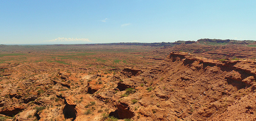
The landscape is dominated by
striking reddish sandstone cliffs, canyons, and eroded formations
carved over millions of years by wind and occasional rain. The
signature feature is Potrero de la Aguada, a vast natural
amphitheater of red and ochre rock walls and layered terraces. The
area is paleontologically rich, with Cretaceous dinosaur footprints
(including theropod and sauropod tracks) and fossils such as the
pterosaur Pterodaustro. Archaeological evidence of pre-Hispanic
occupation (including the Hornillos de Hualtarán ceramic-production
site, roughly 1,000 years old) adds cultural depth.
Best Time to Visit
Visit from April to October for milder
temperatures (daytime highs often 15–22°C / 59–72°F), clearer skies, and
lower humidity. Summer (especially January–February) brings extreme heat
that can exceed 35–40°C (95–104°F), with trails sometimes restricted or
closed for safety if temperatures at the start of a hike reach 33°C
(Guanacos) or 35°C (guided trails). Rainfall is low overall (~300 mm
annually) but concentrated from late spring into early autumn and can
close trails or make the access road slippery. Weekdays outside
Argentine school holidays are quieter.
Hours, Fees, and Access
The park is open every day, including holidays, from 8:00 to 19:00, with
last entry at 17:00. Recent reports (including official social media and
provincial sources) indicate free entry at present, though fees have
been listed in the past and the Administración de Parques Nacionales
(APN) site shows tariff categories. Always confirm current status before
traveling, as policies change with inflation and regulations. Guided
trails require a paid authorized guide (arrange in advance; costs vary
but are typically modest).
There is no public bus service directly to
the park. Rent a car or hire a taxi/tour from San Luis (or from Merlo,
San Juan, or Mendoza). The closest commercial airport is Brigadier Mayor
César Raúl Ojeda (LUQ) in San Luis, with flights from Buenos Aires. From
the RN 147 turnoff, the final dirt section is generally passable in dry
conditions but check road status after rain. Drive slowly for wildlife
(guanacos, armadillos, etc.).
Trails and Activities
Several
trails of varying difficulty start near the visitor/information area and
parking. Some are self-guided; others require a guide or prior
registration. Official details include:
Miradores (self-guided):
~2.2 km / 1.5 hours, low difficulty. Panoramic views of the Farallones
cliffs and Potrero de la Aguada; the main accessible overlook
experience.
Flora (self-guided): ~1.3 km / 45 minutes, low
difficulty. Interpretive trail highlighting native plants adapted to
arid conditions (signage with common and scientific names).
Huellas
del Pasado (guided): ~3 km / ~2.5 hours, medium difficulty. Focuses on
paleontology and geology; includes dinosaur footprints and endemic flora
such as the chica bush.
Guanacos (self-guided with registration at
the information office): ~5 km round-trip / ~3 hours, high difficulty.
Rougher terrain with views of the farallones and southern Potrero; good
chance to see guanacos.
Farallones (guided): ~9 km round-trip / ~4
hours, high difficulty. Descends toward the base of the red cliffs.
Guided departures have fixed windows (earlier in summer due to
heat). Birdwatching is excellent (over 200 species, including Andean
condors, yellow cardinals, and others); best early morning or late
afternoon. Photography is outstanding, especially with the warm
late-afternoon light on the red rock.
Practical Tips and
Facilities
Bring at least 2 liters of water per person (more in
heat); there is no potable water on the trails and limited or
non-potable water at facilities. Pack a hat, sunscreen, sunglasses,
closed comfortable shoes, light snacks, and insect repellent. Shade is
scarce. Thermal amplitude is high, so layers help. No pets are allowed.
Facilities include a visitor/information area, bathrooms, picnic tables
with grills, and a free basic campsite (limited sites, shared bathrooms
with cold showers, tables, fire pits; suitable for tents or small RVs).
A small store/restaurant is nearby on the RN 147 or about 500 m from the
entrance for basics, empanadas, or regional food (hours may be limited,
often Thursday–Sunday). Stock up in San Luis for longer stays. Wi-Fi is
available in the information/parking zones.
Contact the park for
trail status, guides, or questions: WhatsApp 266 473-2754 (daily during
open hours), email sierradelasquijadas@apn.gob.ar, or phone
0266-473-2762 / 0266-444-5141. Follow the official Instagram
(@pn.sierradelasquijadas) for updates.
Base yourself in San Luis city
for more lodging, restaurants, and services (1.5–2.5 hours away), or
look for simple options closer if available. The park pairs well with
other San Luis attractions or a broader Cuyo circuit including places
like Ischigualasto.
Respect the fragile environment, stay on marked
trails, and check conditions the day of your visit. The combination of
dramatic geology, fossils, and relatively light crowds makes it a
rewarding, less-visited destination compared with better-known Argentine
parks.
Topography and Landforms
Elevations range mainly from under 500 m
above sea level in the Desaguadero River valley to 500–900 m across most
of the sierra, with peaks approaching or exceeding 900–1,090 m. Notable
heights include Cerro El Portillo and Cerro El Lindo (below ~1,090 m),
Cerro Los Viejos (~920 m), and Cerros de la Aguada and Cerros de la
Vidriera (~850 m). The landscape divides into six main physiographic
units: the Desaguadero River flood plain, the circular/enclosed Arroyo
de la Aguada valley, steppe, foothills, slopes, and summits.
The
dominant visual character is dramatic arid badlands and eroded red
sandstone sierras. Water and wind erosion have sculpted intense reddish
(umber/ochre) cliffs (farallones), sheer walls, ravines, canyons, rock
towers, terraces, and labyrinthine formations. The signature feature is
the Potrero de la Aguada, a vast natural amphitheater or micro-basin in
the heart of the sierra. It is enclosed by steep, stratified reddish
sandstone and conglomerate walls, with erosion creating capricious
shapes, balconies, and intricate terrain across thousands of hectares.
Temporary watercourses drain this basin toward the Arroyo de la Aguada.
Eastern slopes tend to be gentler; western ones are more abrupt, with
narrow quebradas. The overall relief emerges from surrounding arid
plains.
Geology and Geological History
The park lies in the
San Luis Basin, with sedimentary, metamorphic, and igneous outcrops of
various ages. A major north–south fracture (subparallel to the
Desaguadero River) lifted the Quijadas range. The basin is bounded
eastward by the Sierra de San Luis and connects westward subsurface to
Triassic basins in Mendoza and San Juan provinces; it extends northward
toward Marayes.
Geological development involved three main stages:
Infill (~120–100 million years ago): A sedimentary basin flanked by
highlands (including ancestral Sierras de San Luis and a range along the
Desaguadero course) filled with fluvial, aeolian, and lacustrine
sediments, accumulating more than 1,000 m of material.
Uplift and
folding (beginning ~25 million years ago in the Tertiary, linked to
Sierras Pampeanas and Andean processes): Layers were raised and folded.
Uplift continues with the westward migration of the South American
Plate.
Erosion: Concurrent with and after uplift, creating the modern
valleys, ravines, and amphitheaters such as Potrero de la Aguada.
Key Lower Cretaceous formations exposed in the park (part of the
broader Mesozoic red-bed sequences of central-western Argentina’s
basins) include:
El Jume Formation (~120 mya, oldest): Outcrops
prominently in Potrero de la Aguada; ~300 m thick alternating red
sandstones and claystones from fluvial, aeolian, and lacustrine
settings. It includes a notable paleolake mud column.
El Toscal and
La Cruz Formations (~110 mya): Widespread, forming much of the reddish,
whitish, and gray cliffs and gorges from high-energy fluvial
environments. La Cruz includes basaltic lava layers (~109–107 mya).
Lagarcito Formation (~100 mya): Eastern slopes, dominated by claystones
with some sandstones deposited in interconnected lakes; famous for
exceptional fossil preservation.
A Tertiary San Roque Formation
(~25 mya) of conglomerates, sandstones, claystones, and gypsum appears
in low hills, along with Quaternary fluvial/aeolian deposits (sands,
silts, loess-like materials) and younger alluvial/lacustrine/salt-flat
sediments in flood plains and wetlands. The sequence documents
continental arid-to-semiarid environments across much of the Mesozoic
(Triassic through Cretaceous).
Paleontologically, the park is
significant, especially the Lagarcito Formation’s Loma del Pterodaustro
site (Konservat-Lagerstätte), which yielded abundant, well-preserved
fossils of the filter-feeding pterosaur Pterodaustro guinazui (with its
distinctive upward-curved jaws and fine teeth), fish, invertebrates, and
early plant remains. Other vertebrate tracks and fossils occur in the
formations.
Climate and Hydrology
The climate is semi-arid to
arid serrano (continental arid), with pronounced daily and seasonal
temperature swings. Annual precipitation averages roughly 250–300 mm,
scarce and unevenly distributed—mainly late spring to early autumn
(summer rains), with a dry winter. Relative humidity averages around
55%. Temperatures: average annual maximum ~24°C, minimum ~11°C; January
monthly averages near 31°C (with highs often 35°C+ and occasionally
exceeding 40°C); July minima near 3°C or below freezing. Extreme thermal
amplitude is typical.
Hydrology is dominated by ephemeral streams fed
by storm runoff; surface rocks erode readily. The Potrero de la Aguada
acts as a closed catchment that concentrates rainwater and discharges it
via the Arroyo de la Aguada into the Desaguadero River. The Desaguadero
forms a western boundary (also an interprovincial limit with Mendoza)
and creates a broad flood plain with saline influences. The park
includes portions of the Lagunas de Guanacache wetland complex (a Ramsar
site of international importance), historically a larger system linked
to Andean river inflows, now reduced with salt flats and intermittent
water bodies.
Broader Geographic Context
The park occupies a
critical ecotone (transition zone) between Dry Chaco woodlands (with
quebracho blanco and algarrobo) and the shrub-dominated Monte plains and
plateaus (jarillas/Larrea, cacti, and other xerophytes). Vegetation is
generally sparse and adapted to aridity; soils and land cover reflect
the arid steppe and eroded sedimentary terrain. It preserves a unique
sample of this transitional biogeography in west-central Argentina,
alongside its geological and paleontological values (it is on UNESCO’s
Tentative List for natural criteria related to outstanding landscapes,
geology, and ecosystems).
Flora
The vascular flora is adapted to aridity, intense sun, poor
soils, and erosion. Inventories record roughly 356–416 species
(including infraspecific taxa; about 3.6% of Argentina’s flora in the
more detailed count), in ~208 genera and 58 families. Dicots dominate
(~74%), followed by monocots (~25%), with a few ferns and gymnosperms
(Ephedra). The best-represented families are Poaceae, Asteraceae,
Fabaceae, Solanaceae, Verbenaceae, and Bromeliaceae (together ~56% of
species). Life forms emphasize drought adaptation: phanerophytes and
hemicryptophytes (~24% each), chamaephytes (~22%), and therophytes
(~16%).
Vegetation communities include:
Mixed open forests and
groves with white quebracho (Aspidosperma quebracho-blanco) and
algarrobo/mesquite (Prosopis spp., especially P. flexuosa), plus
contributions of chañar and other Chaco elements.
Shrubby steppes
dominated by jarillas (Larrea spp., Zygophyllaceae), typical of the
Monte, along with garabato, brea, and other thorny shrubs.
Cacti
(tunas, cardons, columnar and smaller forms) and bromeliads (chaguares,
air plants/claveles del aire).
Gallery or riverine vegetation,
halophyte rings on saline flats, pajonales (tussock grasslands), and
rushes.
Rocky slopes with specialized slow-growing woody plants.
Endemics and notable species: Four taxa are exclusive (or nearly so)
to the park and immediate surroundings—Atriplex quixadensis
(Chenopodiaceae/Amaranthaceae), Senecio hualtaranensis (Asteraceae),
Sclerophylax difulvioi (Solanaceae), and Gomphrena colosacana var.
andersonii (Amaranthaceae). Many of these and other endemics face
threats from restricted range, erosion, and human activity; several are
critically endangered, endangered, or vulnerable. About 120 Argentine
endemics occur in the park. The emblematic chica (Ramorinoa girolae) is
a slow-growing, extremely hard-wooded shrub or small tree of rocky Monte
slopes; it is nearly leafless, with green photosynthetic stems/branches,
deep roots, and infrequent yellow-orange flowers.
Invasive/introduced
plants include ~17 species, notably French tamarisk (Tamarix), which
forms dense stands along streams. Overall, the flora shows strong
adaptation to prolonged drought via reduced leaves, deep roots, water
storage (succulents), and other xerophytic traits. Historical grazing
and clearing have degraded some woodland patches, with restoration
efforts underway after removal of unauthorized livestock.
Fauna
About 270 vertebrate species have been recorded (including a few
introduced), reflecting the ecotonal mix of Chaco, Monte, Andean, and
some Patagonian influences. Biodiversity is high for an arid zone, with
important threatened taxa.
Mammals include:
Guanaco (Lama
guanicoe), often in open areas.
Maras: Patagonian mara (Dolichotis
patagonum) and Chacoan mara / conejo de los palos (D. salinicola).
Collared peccary (Pecari/Dicotyles tajacu) and gray brocket deer /
corzuela parda (Mazama/Subulo gouazoubira).
Predators: puma (Puma
concolor), gray fox / zorro gris pampeano (Lycalopex gymnocercus),
Geoffroy’s cat, and others.
The endangered pink fairy armadillo /
pichiciego menor (Chlamyphorus truncatus), a small fossorial specialist.
Other rodents (viscachas, cavies, tuco-tucos) and smaller carnivores.
Birds number in the 140–190 range in various counts. Highlights
include the Andean condor (Vultur gryphus, using cliffs for roosting),
black-chested buzzard-eagle / águila mora (Geranoaetus melanoleucus),
the endangered crowned solitary eagle / águila coronada (Buteogallus
coronatus), elegant crested tinamou / martineta (Eudromia elegans),
various tinamous, raptors, and the Andean swift / vencejo blanco
(Aeronautes andecolus), an aerial specialist that nests in crevices.
Other notes include blue-crowned parakeet, yellow cardinal, and Monte
endemics such as sandy gallito.
Reptiles and amphibians: Herpetofauna
includes ~25 species (earlier lists; more in broader SIB data).
Emblematic is the Argentine/Chaco tortoise (Chelonoidis chilensis),
which digs burrows for summer heat refuge and winter hibernation, feeds
on cacti, plants, insects, and snails, and is threatened by pet trade.
Others include Argentine boa (Boa constrictor occidentalis), Darwin’s
tree iguana and other Liolaemus, tegus (Salvator), various snakes
(yarará, rattlesnake, colubrids), geckos, and amphibians such as the
Mendoza four-eyed frog / escuercito (Pleurodema nebulosum) and common
toad (Rhinella arenarum). Many are adapted to arid or rocky habitats.
Paleontological significance adds depth: Cretaceous formations (notably
Lagarcito) have yielded abundant fossils, including the filter-feeding
pterosaur Pterodaustro guinazui.
Conservation Context
The park
is critical for endemic plants, the crowned eagle, pink fairy armadillo,
tortoise, and connectivity of the Chaco–Monte transition. Challenges
include invasive plants (tamarisk), historical grazing and clearing
(partial recovery efforts noted), climate pressures, and limited water.
Official emblems often highlight the tortoise, chica, and Andean swift.
Trails allow observation of characteristic vegetation and wildlife such
as guanacos and maras, with interpretive signage.