Location: Mato Grosso do Sul Map
Area: 76,400 ha
Serra da Bodoquena National Park (Parque Nacional da Serra da
Bodoquena) is a federal protected area of about 77,000 hectares in
southwestern Mato Grosso do Sul, Brazil. Created in 2000 and managed
by ICMBio, it protects a rare enclave of Atlantic Forest within the
Cerrado biome near the Pantanal. It features karst limestone
landscapes, crystal-clear turquoise-to-emerald rivers (colored and
filtered by dissolved calcium carbonate), canyons with walls up to
90–150 m high, waterfalls (including growing tufa formations),
sinkholes (sumidouros), resurgences, caves, and rich biodiversity
including jaguars, giant anteaters, harpy eagles, blue macaws, and
many other species.
Public access is tightly controlled. The park
has no public entrance gate or extensive visitor infrastructure.
Visits require an ICMBio-accredited guide (condutor), and most
access occurs via private properties or partners such as Eco Serrana
Park. Currently, two main trails are officially open: the Rio
Perdido (Sumidouro-Ressurgência) Trail near Bonito and the Salobra
River Canyon Trail near Bodoquena. Many popular “Serra da Bodoquena”
experiences (e.g., Cachoeiras Serra da Bodoquena) are on nearby
private land outside the park boundaries.
How to Get There and Access
Base towns: Bodoquena (main gateway
for the Salobra canyon; ~70 km / 1–1.5 hours from Bonito via MS-178)
and Bonito (for Rio Perdido). Campo Grande is ~260–270 km (3.5+
hours) via BR-262 to Miranda then MS-339.
Transport: Car or
rental is most practical. Buses run from Campo Grande (~5 hours) and
Bonito (~1.5 hours). Bonito has a small airport; Campo Grande has
better flight options.
Access rules: Book guides in advance via
ICMBio-accredited operators or partners (list available on the
ICMBio site). Groups are limited (often up to 10). Hours are
generally 8:00–17:00. No free independent entry. Some private access
points charge for entry/services even though the park itself has no
general entrance fee (guide fees apply; confirm current costs). Cell
signal is often absent inside the park.
Main Trails and
Activities
Rio Perdido Trail (Sumidouro-Ressurgência, southern
fragment, near Bonito): The river disappears into a sinkhole,
travels ~1.2 km underground, then resurfaces. The well-marked trail
(~3.5–7.5 km round-trip depending on route) features boardwalks,
decks, labeled trees, swimming pools, and floating/snorkeling
opportunities. It is relatively easy and shaded in places, with good
environmental interpretation. Open since around 2021. Bring plenty
of drinking water (local river water is high in minerals and not
recommended for drinking).
Salobra River Canyon Trail (northern
fragment, near Bodoquena): A highlight—acquatrekking (walking
in/along the river) through dramatic limestone walls (often cited
80–150 m) and crystalline waters. Distances are commonly reported as
~5–7.6 km round-trip (moderate difficulty; 4–6 hours). Expect
multiple river crossings (water to knees or waist), natural pools,
small waterfalls, and birdwatching. Access typically via Eco Serrana
Park or similar partners, often including lunch. Options sometimes
include kayak (duck) segments. Strong shoes with good grip are
mandatory; you will get wet.
Nearby private attractions (often
combined in itineraries): Cachoeiras Serra da Bodoquena (~2.5 km
easy family-friendly trail along Rio Betione with multiple bathing
stops, boat ride, balneário with pool/tirolesa/kayak, and lunch;
~R$340–440 adult depending on season in 2025/2026 figures); Boca da
Onça (waterfalls including one of the state’s tallest, with optional
90 m rappel); Rio Azul floating; and others. These are not inside
the national park proper but share the same geological and
ecological setting.
Best Time to Visit
The dry season
(roughly May–September/October, especially June–August) is widely
preferred: clearer waters for floating and snorkeling, firmer
trails, lower rain risk, and comfortable temperatures (roughly
15–30°C). Shoulder seasons (March–May and September–November)
balance greenery and water levels. The rainy season (October–April)
brings lush vegetation and fuller waterfalls but muddier trails,
higher cancellation risk after heavy rain, and reduced water
clarity. High season (July, Christmas/New Year, Carnival, long
weekends) requires early booking. The region is visitable
year-round, but conditions affect activities.
Practical
Visiting Tips
What to bring: Closed-toe shoes or water-trail
shoes with good grip (mandatory for most trails; no flip-flops);
swimsuit and quick-dry clothes; towel and dry change of clothes;
biodegradable sunscreen and insect repellent (note: some floating
areas restrict non-biodegradable products); hat, sunglasses, water
bottle (plenty of drinking water), light snacks, waterproof bag or
phone case, and camera. A light rain jacket is useful. Lockers are
available at some private sites.
Booking and rules: Reserve
guides and private attractions well in advance, especially in high
season. Bonito has a mandatory Environmental Conservation Tax (TCA,
~R$15 per person per day of activities since late 2025) paid via the
official municipal site before vouchers can be issued for many
attractions. Confirm current requirements. Follow guide instructions
strictly—do not touch fragile tufa formations, stay on trails, and
respect group limits.
Difficulty and fitness: Rio Perdido is
easier; Salobra canyon is moderate and involves wet, uneven terrain.
Suitable for reasonably fit adults and older children (age minimums
often apply, e.g., around 8 for some canyon options). Not ideal for
those with significant mobility issues.
Health and safety: Watch
for sudden water level rises (“cabeça d’água”). No cell signal in
much of the park—inform someone of your plans. River water is clean
but mineral-rich. Bring a basic first-aid mindset and stay hydrated
in the heat.
Costs: Guide fees vary (no fixed park entry).
Private full-day attractions with lunch often run several hundred
reais per person. Transport is extra. Prices change—confirm
directly.
Combine visits: Pair the park trails with Bonito’s
famous floating (e.g., Rio Sucuri or similar) and private sites in
Bodoquena for a 2–4 day regional itinerary. Bodoquena itself is
quieter and more affordable than Bonito.
The park emphasizes
low-impact ecotourism and education. Guided visits help protect the
sensitive karst systems and biodiversity while offering a more
contemplative experience than some of the busier Bonito attractions.
Always verify the latest access rules, open trails, and conditions
with ICMBio or accredited operators before traveling, as visitation
is still evolving.
Geomorphology and Elevation
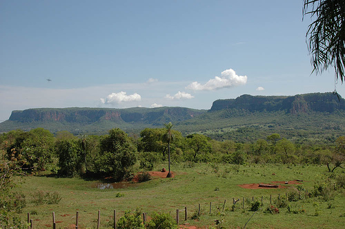
The dominant landform is an elevated,
elongated carbonate plateau that stands above the surrounding lowlands.
Elevations commonly range from about 400–600 m, with local highs
approaching or exceeding 700–800 m in places; the surrounding Pantanal
plains lie at roughly 60–180 m. The western flank facing the Pantanal is
generally steeper and more escarped, while the eastern side grades more
gently toward the Miranda River Depression.
The plateau functions as
a regional water divide between the Paraguay and Miranda river basins.
Rivers have deeply incised the limestone, producing narrow valleys, deep
canyons (with walls exceeding 100 m in places), sheer cliffs, and
residual hills. Classic karst landforms are abundant: sinkholes
(sumidouros), dolines, resurgences (ressurgências), underground
conduits, and surface solution features such as lapiés (karren fields)
on higher summits. The name “Bodoquena” itself derives from Tupi-Guarani
and roughly means “spring on top of the mountain range,” reflecting the
abundance of headwaters.
Geology
The landscape is a classic
karst developed primarily on Neoproterozoic (Ediacaran) carbonate rocks
of the Corumbá Group, especially limestones and dolomites of the Bocaina
Formation (and related units). These rocks formed around 600 million
years ago in shallow tropical marine settings within the Paraguay Fold
Belt. Dissolution by slightly acidic groundwater has created extensive
cave systems, some containing underground rivers and speleothems.
A
particularly characteristic feature is the widespread deposition of
Quaternary tufa (travertine / calcário de tufa). These freshwater
limestone deposits form natural dams, stepped waterfalls, and pools
along current and abandoned drainage channels. Both modern active tufas
and older terrace deposits occur; the latter preserve excellent leaf
molds useful for paleoclimatic interpretation. The pure limestone
substrate is the primary reason the region’s rivers have exceptionally
low turbidity.
Hydrology and Rivers
The park’s rivers are
famous for their crystal-clear, turquoise-to-emerald waters with
virtually zero turbidity. Pure limestone acts as a natural filter,
precipitating calcium carbonate and removing suspended sediments. The
waters are bicarbonate-rich and can taste slightly brackish. Key streams
include:
Rio Salobra (northern fragment): carves deep canyons
with vertical walls often exceeding 90–100 m. It is associated with
major waterfalls, including Boca da Onça (approximately 156 m, the
highest in Mato Grosso do Sul).
Rio Perdido (southern fragment):
named for its habit of disappearing underground through sumidouros and
reappearing at ressurgências (one well-known section disappears and
re-emerges after roughly 1.2 km).
Other important watercourses such
as the Betione and Formoso, which ultimately contribute to the Miranda
and Paraguay systems and help feed the Pantanal wetlands.
Numerous springs, underground flow paths, natural pools formed by tufa
dams, and cascading waterfalls characterize the drainage network. The
clarity allows excellent visibility of the rocky beds and aquatic life.
Climate
The climate is tropical with a well-defined dry season.
Annual precipitation typically ranges from about 1,200–1,500 mm,
concentrated in the rainy summer months. The dry season lasts roughly
3–4 months (mainly May–August), with brief dry spells possible. Average
temperatures are around 22–25 °C; summer highs often reach the high 20s
to low 30s °C, while winter lows can drop into the teens, with extremes
occasionally approaching 0 °C or exceeding 40 °C. Relative humidity is
commonly near 80 %.
Vegetation Context
Although the park is
classified within the Cerrado biome, it contains important remnants of
seasonal semi-deciduous and deciduous forest (including the largest
continuous Atlantic Forest fragment remaining in Mato Grosso do Sul),
riparian gallery forests, and grassy areas. These form a transition
mosaic between Cerrado, Atlantic Forest elements, and
Pantanal-influenced environments. Riparian forests are especially
important for protecting the clear waters from sediment inputs.