Location: Tipaza Province Map
Situated on the coast of the Mediterranean Sea Tipaza Archaeological Site (تيبازة) was originally found by the Phoenicians as a trade post in the North Africa. It became known as one of the most important cities in the region. Tipasa ancient ruins are located on the Mediterranean coast about 70 km from the city of Algiers. It was found by Phoenician settlers who established several colonies in the North Africa. Roman Emperor Claudius turned it into a colony in the first century AD. It grew further under the rule of the Roman Empire. During early Christian period Romans built Great Basilica, Basilica of Saint Salsa and Basilica of Alexander. Great Basilica is probably the most significant and most interesting among Christian churches of Tipaza. Great Basilica contains a large burial ground underneath its floor cut into the solid rock. One of these graves has circular shape with a diameter of 19m. Remains of 24 early Christians were discovered here.
Additionally Tipaza had an beautiful public baths, amphitheater as well as two cemeteries. The city was abandoned in the 5th century then Vandals from Europe invaded the region from Spain. Tipasa was abandoned and resettled only centuries later. The ancient ruins were left largely undisturbed and hence in a fairly descent condition. Ancient city of Tipaza was included in the UNESCO World Heritage List in 1982.
On a promontory sheltered from Mount Chenoua, the Phoenicians founded a trading post around the 6th century BC. BC: from this origin the city takes its name which means passage or stopover, the Arabs called it Tefassed which means deteriorated, the French called it Tipaza. For other sources, Tipasa would be the distortion of the Berber word Tafsa, which means sandstone or limestone, still in use in many regions of the Maghreb. The name of this place, in the language of the first inhabitants of this region (Imazighens who call themselves "Leqbayel" since what we call Kabylia today originally extended from the Chenwa region, west of Algiers, as far as Collo to the east), was Tifezza, which is the plural of the word "tafezza" which means disintegrated sandstone (therefore sandy), such as we can see today, along the coast, at Tipaza (and not Tipasa).
The location of the trading post was chosen as a staging point between Icosium (Algiers) and Caesarea (Cherchel) providing refuge for navigators on their route to the Pillars of Hercules (Gibraltar). The counter developed and became around the 2nd century BC. BC a true Punic city subservient to Carthage. Stelae representing Phoenician symbols such as the so-called Sign of Tanit and coins typical of Carthage representing the horse and the palm tree which testify to the Punic influence on the city in addition to the funerary furniture found in the various Punic necropolises attest to the The importance of this city, the necropolises considered by UNESCO to be among the oldest and most extensive in the Punic world.
Apart from pieces of Campanian ceramics, Hellenistic
lamps and coins representing Massinissa, Juba II and Ptolemy, no datable
monument from this period could be found by archaeologists, most
probably due to the architectural changes of the Roman era. However,
being on the east-west road axis of Mauretania, the city could not
escape the Berber rivalries on these territories between the Numidian
kings Syphax, Massinissa, Bocchus 1st, Juba 1st and Bocchus II. However,
the city experienced a certain growth under King Juba II and became,
with its capital Caesaria (Caesarea) located about twenty kilometers to
the west, one of the centers of Greco-Roman culture and a center of
transit and transport. active trading.
In 40 AD, Ptolemy, son of
Juba II, is executed by Caligula, and Mauretania definitively comes
under direct Roman administration.
During the reign of the Roman Emperor Claudius I
between 41 and 54 AD. Mauretania is divided into two provinces:
Caesarian Mauretania which takes its name from its capital Caesarea
(current Cherchell) on a territory corresponding to the center and west
of present-day Algeria, and Tingitanian Mauretania with Tingis (current
Tangier) as capital, on a territory corresponding to the north of
current Morocco.
In the year 46, Tipasa took on the status of a
municipality under Latin law (jus latinus). Initially, the city was
located on the hill at the current location of the lighthouse
overlooking the old port and included houses, the forum, the judicial
basilica and the capitol, all delimited by an enclosure. The city then
extends over the plain as well as the east and west hills with numerous
public and private buildings such as the frescoed villa; the whole is
surrounded by a larger enclosure of approximately 2,200 meters. Tipasa
was thus elevated to the rank of Roman colony: colonia Aelia Tipasensis.
The city received all the prerogatives of Roman citizenship and at the
end of the 2nd century the city reached its peak at the time of the last
Antonines and the Severians with a population which was growing,
according to the "with reservation" estimates of Stéphane Gsell , with
20,000 inhabitants called Tipasitani or Tipasenses.
In the first half of the 3rd century, Christianity
made its appearance there. The epitaph of Rasinia Secunda, whose death
is dated October 17, 237, is the oldest dated Christian inscription in
Africa (238).
From the 3rd to the 4th century, Christianity
experienced real growth, as evidenced by the multitude of religious
buildings such as the great basilica considered among the largest in
ancient Africa, the basilica of Bishop Alexander, the basilica of Saint
Salsa, as well as the multitude of necropolises developed around places
of worship.
In the middle of the 4th century, Tipasa, like many
cities in North Africa, suffered the horrors of the Donatist schism.
This period was marked between 371 and 372 by the revolt of Firmus
supported by numerous indigenous tribes, raiders as well as Donatists
full of religious hatred against the Roman Empire of Valentinian I.
Unlike Icosium and Caesarea which were stormed by Firmus, Tipasa was
able to resist this invasion, which probably increased the prosperity of
the city for a few more years.
Although it was surrounded by a protective enclosure,
this did not prevent its destruction in the year 430 by the Vandals led
by Genseric. At the end of the 5th century, under Huneric, Christians
were persecuted and fled by sea to Spain.
In 534, the Byzantines
took back Africa, Tipasa must have regained a certain peace and
prosperity as evidenced by certain expansion, re-employment or
rehabilitation works. Beyond the sixth century, life continued in
precariousness and provisionality and Tipasa ended up suffering the fate
of all abandoned cities, delivered to the alluvium of the wadis and the
burial of the dunes.
The first excavations took place only in the
19th century. Stéphane Gsell published a monograph in 1894. Then Jean
Baradez in 1946 introduced modern and scientific working methods and
established the museum's first collections.
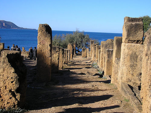
Unlike Timgad and Djemila whose ruins appear compact
and easily readable, Tipasa offers a fragmented site. This is due to the
fact that not everything has been cleared and a good part of the city is
still under sediment. Thus the remains of the large thermal baths, along
the street which connects the museum to the archaeological park, have
their base four meters below today's ground level.
As it stands,
the ruins are presented in two large masses. The first, located outside
the walls, at the entrance to the current city, to the right of the road
coming from Algiers, corresponds to a large necropolis with the funerary
basilica of Sainte Salsa. The second is the archaeological park, at the
western exit of the modern city, which brings together the majority of
the monuments unearthed.
Between the two, near the port, the
museum. And the temple is famous for its abundant tourism.
The Passion of Holy Salsa
The Passion of Saint
Salsa is the story of a fourteen-year-old girl inspired by the Christian
faith but whose parents remained attached to paganism, who one day bring
her to the hill of the temples to attend a festival in honor of an idol
in the shape of a bronze dragon with a golden head and eyes shining with
precious stones. Outraged by the sacrifices and impure rejoicings of the
adoring crowd, she took advantage of the night to throw the dragon's
head into the sea. Once the sacrilege was revealed, the girl was stoned,
trampled and thrown into the sea in order to remain unburied. A Gallic
sailor having dropped anchor in calm weather at the port of Tipasa,
finds himself confronted with a storm which puts the vessel in danger.
In the evening he received the order in the middle of his sleep to
collect the body and give it burial. He throws himself into the sea,
takes the body in his arms and as soon as the body is out of the water,
the sea calms down. The young girl is buried in a humble chapel on a
hill outside the ramparts. According to the Passion of Saint Salsa and
during the revolt of Firmus, the latter besieging the city of Tipasa
without being able to force the ramparts, he entered the chapel to
implore the protection and support of the martyr, his prayers were
rejected, his offerings fall to the ground and his candles are
extinguished, he then strikes his tomb with his spear. Defeated on the
walls of Tipasa he perished shortly after.
Description of the
hill
The ancient city of Tipasa delimited by its walls is located
between two hills, one to the west called Ras el Knissa and the other to
the east called Koudiat Zarzour. On the western hill as on the eastern
hill, vast Christian necropolises developed. The eastern hill is called
the hill of Saint Salsa. This hill represents an immense cemetery where
“the sarcophagi crowd around the church like sheep around the good
shepherd”.
The construction of the necropolis began in the pagan era, as evidenced by tombs from earlier periods, one of the most representative of which is the Punic vault cut into the cliff which has since fallen into the sea, as well as others. pagan tombs recognizable by their semi-circular cup shape and columbariums which are sepulchral buildings intended to receive cinerary urns.
Leaning against and opening onto the ramparts, the remains of a small basilica dating from the end of the 5th century where worship was given to the martyrs Peter and Paul attested by a marble plaque currently preserved on the museum patio on which we read " to blessed Peter and Paul..." Excavations inside the basilica revealed two anonymous sarcophagi as well as lamps decorated with symbols of resurrection (peacocks, Jonah emerging from the belly of the whale), chrism and Saint Peter defeating Satan. Around the walls of the basilica, numerous sarcophagi stand side by side, particularly along the south wall where there are 14 other sarcophagi delimited by an enclosure; the whole probably represents a martyrium.
The basilica is located about 300 meters outside the
ramparts at the top of the hill. It is very likely that initially at
this location a small chapel was built in the middle of a pagan
necropolis to house the tomb of the saint, in the family burial place,
this chapel was gradually enlarged to transform into a church. The
Sainte-Salsa basilica was initially square in shape, measuring 15 meters
on each side; the entrance according to custom opens towards the east
while the apse has a western orientation, the walls of the church were
built of cut stone. Inside, the church is formed by a central nave 7.5
meters wide delimited by two rows of pillars topped with archivolts and
two side aisles each 2.5 meters wide. In the center of this basilica, a
tomb well preserved because of its religious value for the Tipasian
community, surmounted by a semi-cylindrical shape, presents an epitaph
which tells us that it belonged to Fabia Salsa, a matron very probably
pagan ancestor of Holy Salsa.
In the 5th century, the entire
central nave except the tomb of Fabia Salsa was occupied by an
ornamental mosaic; on the apse side a frame surrounds a commemorative
inscription dedicated to Potenti, most probably a bishop from the middle
of the 5th century. In the first half of the 6th century, the church
underwent significant modifications; it was enlarged to reach 30 meters
in length, the side aisles were topped with stands, the stairs of which
still exist on either side of the entrance. To the north, a small open
door in the wall leads to an area martyrum (martyrs' cemetery) which
slopes down towards the cliff. A quadrangular room contains a feast
table (“mensa”). To the south, the church is flanked by a more sumptuous
funerary enclosure and a “fighters” room.
Inside the church, the
tomb of Fabia Salsa was covered by a base covered with marble slabs and
surrounded by a grille. On this base a marble sarcophagus representing
the legend of Selene and Endymion was placed; due to its central
location and the savagery with which it was destroyed, S. Gsell put
forward the hypothesis that this sarcophagus contained the venerated
remains of Saint Salsa.
Formerly a private property, the garden located to the
east of the archaeological park has become, by donation, an annex of the
latter. We see a whole series of architectural elements such as columns,
capitals, claustras, lintels but also amphorae, jars and some
sarcophagi.
We also notice large blocks of blocking and masonry
of significant elevation which correspond to the remains of the large
thermal baths whose surface area was equivalent to that of the
amphitheater but whose clearance remains minimal due to the burial under
the constructions of the modern city. On the way to the museum, we
appreciate the mass of its pillars which rise nine meters above the
mosaic of the floor of the frigidarium located four meters below the
current street level.
Before crossing the enclosure, a path climbs in steps
towards the oldest part of the city where the remains of the forum and a
judicial basilica from the 3rd century BC were found.
The
entrance to the archaeological site is to the east of the ruins. Tipasa
National Park is accessed at the remains of an imposing amphitheater.
Like any Roman city, two main roads cross it: the decumanus maximus and
the cardo. The first is an extension of the road which linked Icosium
(Algiers) to Caesarea. The second, the perpendicular route which makes
an angle with the decumanus maximus, plunges north towards the sea.
Going west, the decumanus maximus, which spreads its bumpy slabs
over a width of fourteen meters, leads to the Nymphaeum. Still further
west, towards the Caesarea Gate, is the theater built on an elevation.
From there, a path, which winds through dense vegetation, leads us
to the large Christian basilica, built in the 4th century AD, after
passing a swimming pool and a well. The basilica, built on a promontory,
overlooks the Mediterranean Sea and adjoins a necropolis whose main
building is the circular mausoleum. Not far from there, at the western
end of the archaeological park, a stele in memory of Albert Camus was
erected in 1961, facing the sea and Mount Chenoua.
At the foot of
the foothills of the apse, a steep path takes you further down to the
residential seaside district. You descend overlooking a construction
with a monumental staircase extended by small thermal baths in a good
state of conservation. We pass near the vats (dolia) of a garum factory.
Further on, other small thermal baths and a Roman villa where traces of
mosaic are visible. It is the Villa des Fresques which is the most
remarkable residence of this ensemble.
We arrive at the cardo.
Going up the track towards the south allows the study of the water
distribution and sewer system which has been brought to light. At the
intersection of the cardo and the decumanus maximus, two temples
arranged almost symmetrically: the anonymous temple and the new zemple.