Location: Wilaya (region) of Algiers
Algiers-in Arabic الجزارر, Al-Jazā'ir or Al Djazāir; more
commonly called: الدزاير, Eddzayer; in Berber: led,
ledzayer-nicknamed El Bahdja ("the joyous"), El mahroussa ("the
well-kept ") or " the White ", is the capital of Algeria and is its
most populous city.
Located on the edge of the Mediterranean
Sea, the city gives its name to the wilaya of which it is the
capital. The city of Algiers is in fact made up of several communes
and has neither legal personality nor administrative structure in
its own right.
The Urban Unit of Algiers had 2,481,788
inhabitants according to the Algerian National Statistics Office
according to the last census of 2008. While the agglomeration had
about 6,727,806 inhabitants in 2010 according to the ranking of the
100 largest cities in the world by World Gazetteer and 7,796,923
inhabitants in 2015 according to Population Data, Algiers is the
largest agglomeration in the Maghreb.
Algiers was founded in
the fourth century BC, as a Phoenician counter in the Berber
country, under the name Ikosim. It was occupied by the Romans,
Vandals, Byzantines and Arabs and in the Early Middle Ages by the
Berber tribe of Beni-Mezghana. It is the Berber ruler of the Zirid
Dynasty Bologhine ibn Ziri, in the middle of the tenth century who
founded the present Algiers, under his name El-Djazaïr or Lezzayer,
still used today to designate it in Arabic and Berber. It took its
role as capital of Algeria only from the period of the regency of
Algiers in 1515. It is then one of the most important cities of the
Mediterranean Sea between the sixteenth century and the beginning of
the nineteenth century, practicing the corso, and to which the
maritime powers pay a tax for the passage of their fleet. Its role
as capital of the country was confirmed during the French
colonization where it became the seat of the Governor General of
Algeria. Algiers was the capital of free France from 1942 to 1944.
Since the independence of Algeria in 1962, which became the capital
of the Algerian state, it has housed the headquarters of the
country's political institutions in addition to playing a leading
role economically.
1. The Casbah of Algiers
Description: A UNESCO World Heritage
Site, the Casbah is the historic heart of Algiers, a labyrinth of narrow
alleys, whitewashed houses, and Ottoman-era architecture. Dating back to
the 10th century, it was once a fortress and trading hub.
Highlights:
Palaces: Visit Dar Aziza and Dar Khedaoudj, ornate Ottoman residences
with intricate tiles and courtyards.
Mosques: The Ketchaoua Mosque, a
striking blend of Moorish and Byzantine styles, and the Ali Bitchin
Mosque, known for its history tied to a former pirate-turned-admiral.
Vibes: Expect bustling markets, artisans selling crafts, and street food
like brik (savory pastry) or karantika (chickpea pie).
Why Visit?:
It’s a living museum of Algiers’ history, though some areas are in need
of restoration. Guided tours are recommended for safety and context.
2.
Basilique Notre Dame d'Afrique
Description: Perched on a cliff overlooking the Bay of Algiers, this
19th-century Catholic basilica is a symbol of religious harmony, revered
by both Christians and Muslims.
Highlights:
Architecture: French
colonial design with a neo-Byzantine dome and stunning mosaics.
Views: Panoramic vistas of the Mediterranean and Algiers’ skyline.
Inscriptions: Inside, a famous quote reads, “Our Lady of Africa, pray
for us and for the Muslims,” reflecting inclusivity.
Why Visit?: A
peaceful spot for reflection and photography, especially at sunset. The
surrounding Bologhine neighborhood has charming cafes.
3. Le
Jardin d’Essai du Hamma (Hamma Test Garden)
Description: A sprawling
58-hectare botanical garden in the El Hamma district, established in
1832 by the French. It’s one of the largest and oldest botanical gardens
in the Mediterranean.
Highlights:
Flora: Over 3,000 plant species,
including rare palms, exotic trees, and a bamboo grove.
Features:
French-style formal gardens, an English garden, and a small zoo with
peacocks and tortoises.
Cultural Note: Scenes from the 1930s film
Tarzan the Ape Man were shot here.
Why Visit?: Ideal for a relaxing
stroll, picnics, or learning about Algeria’s biodiversity. The nearby
Museum of Fine Arts adds a cultural touch.
4. The Martyrs’
Memorial (Maqam Echahid)
Description: An iconic 92-meter-tall
monument in the El Madania district, built in 1982 to commemorate
Algeria’s independence from France.
Highlights:
Design: Shaped
like three palm leaves sheltering an eternal flame, symbolizing unity
and sacrifice.
Museum: The adjacent Museum of the Moudjahid
chronicles Algeria’s liberation struggle with artifacts and exhibits.
Views: Offers sweeping views of Algiers’ skyline and port from its
hilltop location.
Why Visit?: A must for understanding Algeria’s
modern history and enjoying a panoramic perspective of the city.
5. New Mosque or the Great Mosque (Djemaa el- Djedid)
Description: One of the largest mosques in the world, completed in 2019
in the Mohammadia district. Its modern design contrasts with the city’s
older Islamic architecture.
Highlights:
Scale: The minaret, at 265
meters, is the tallest in Africa, with an elevator offering 360-degree
views.
Interior: Can accommodate 120,000 worshippers; features
intricate marble work and a vast prayer hall.
Cultural Hub: Includes
a library, museum, and conference center promoting Islamic scholarship.
Why Visit?: A marvel of contemporary architecture and a testament to
Algeria’s cultural ambitions.
6. The Corniche and Algiers
Waterfront
Description: Algiers’ Mediterranean coastline stretches
along the Bay of Algiers, with a lively corniche perfect for walks,
dining, and people-watching.
Highlights:
Sidi Fredj: A popular
marina with restaurants serving fresh seafood like grilled sardines or
chakhchoukha (a local stew).
Beaches: Nearby beaches like Zeralda or
Ain Taya offer swimming and water sports, though they can get crowded in
summer.
Nightlife: The corniche comes alive at night with street
vendors, tea stalls, and live music.
Why Visit?: A great spot to soak
in Algiers’ coastal charm and vibrant street culture.
7. Bardo
National Museum of Prehistory and Ethnography
Description: Housed in
a 17th-century Ottoman mansion in the Mustapha district, this museum
showcases Algeria’s prehistoric and cultural heritage.
Highlights:
Exhibits: Fossils, Neolithic tools, and Berber jewelry, alongside
ethnographic displays of traditional Algerian life.
Architecture: The
building itself is a gem, with tiled courtyards and carved woodwork.
Why Visit?: Perfect for history buffs wanting insight into Algeria’s
ancient roots and diverse cultural traditions.
8. Place des
Martyrs (Place des Emir Abdelkader)
Description: A bustling square at
the edge of the Casbah, connecting the old city to the modern downtown.
It’s a hub for locals and visitors alike.
Highlights:
Statue: A
prominent statue of Emir Abdelkader, a national hero who resisted French
colonization.
Surroundings: Nearby colonial-era buildings, like the
Grande Poste (a grand post office), showcase French architectural
influence.
Markets: Street stalls sell everything from spices to
souvenirs.
Why Visit?: A lively spot to feel the pulse of Algiers and
explore its blend of old and new.
9. Tipaza (Day Trip from
Algiers)
Description: While technically outside Algiers (about 70 km
west), Tipaza is an easy day trip and a must-see for its Roman ruins and
seaside beauty.
Highlights:
Ruins: Roman amphitheaters, basilicas,
and mosaics from the 2nd century AD, a UNESCO World Heritage Site.
Scenery: Stunning cliffs and beaches where writer Albert Camus found
inspiration (he famously wrote about Tipaza’s “glory of light”).
Dining: Fresh fish restaurants along the coast.
Why Visit?: Combines
history, nature, and a taste of Algeria’s Mediterranean allure.
Practical Tips for Visiting Algiers
Getting Around: Taxis,
ride-hailing apps like Yassir, and the Algiers Metro (clean and
efficient) are the best ways to navigate. The Casbah is best explored on
foot with a guide.
Language: Arabic and Berber are official
languages, but French is widely spoken. English is less common, so basic
French phrases help.
Safety: Algiers is generally safe for tourists,
but stick to well-traveled areas, especially in the Casbah, and avoid
flashing valuables.
Culture: Dress modestly, especially near
religious sites. Locals are warm but may be reserved with
strangers—smile and greet with “Salam” (arabic for "Peace") to break the ice.
Cuisine: Try
local dishes like couscous, tajine, or shorba (soup) at restaurants like
Dar Djeddi in the Casbah or Le Dauphin on the waterfront.
The city was founded in 944 by one of the founders
of the Berber dynasty Zirid Bologgin ibn Ziri on the site of the
ancient Phoenician settlement Ikosim, which was later renamed the
Icosium by the Romans. Under Vespasian, the inhabitants of Icosios
were given Latin law. Although the Zirids were overthrown by Roger
II of Sicily in 1148, they lost control of Algeria as early as 1014,
losing it to their fellow tribesmen Hammadids. In 1159, Almohad
established control of the city. In the 13th century, the city
passed under the control of the Sultans of Tlemcen. Being nominally
part of Tlemcen, Algeria retained significant independence.
At the beginning of 1302, the island of Penon at the entrance to the
bay of Algeria was captured by the Spaniards, resulting in increased
trade between Algeria and Spain. Nevertheless, the significance of
Algeria was insignificant until the expulsion of the Moors from
Spain, many of which found refuge in Algeria. In 1510, after the
occupation of Oran and several other cities on the coast of North
Africa, the Spaniards strengthened the island of Penon and
introduced customs duties in order to suppress the activities of
pirates.
In 1516, the emir of Algeria,
Selim Teumi, invited the corsair brothers Aruj and Hayreddin
Barbarossa to expel the Spaniards from Algeria. In the same year,
Aruj Barbarossa captured the city and, after the assassination of
Selim, became the de facto ruler of the city. After his death,
control of the city passed to his brother, Hayreddin. Hayreddin
Barbarossa lost control of Algeria in 1524, but regained it in 1529
and then invited the Sultan Suleiman the Magnificent to take
sovereignty over the territory and annex Algeria to the Ottoman
Empire.
Algeria has become the main base of the Berber
pirates. During the Algerian expedition in October 1541, the King of
Spain and the Holy Roman Emperor Charles V intended to take over the
city, however, a significant number of his ships were damaged as a
result of the storm, and his army of 30,000 was defeated by Algerian
Pasha Hassan.
Since Algeria was on the periphery of the
economic interests of both the Ottoman Empire and Europe, and
depending on the Mediterranean Sea, which was increasingly used by
Europeans for shipping, piracy became the main area of its
economy. The result of this was the intensification of the struggle
of various states with Algerian pirates who controlled the Western
Mediterranean and whose raids reached the coast of Iceland.
In the Ottoman period, the city was surrounded on all sides, except
for the promenade, with fortress walls. Access to the city was
provided through five gates. In 1556, a citadel was erected in the
highest part of the wall. The main road that crossed the city from
north to south divided it into the Upper and Lower Towns. The upper
city (al-Gabal or 'mountain') consisted of 50 quarters in which the
Andalusians, Jews, Moors and Kabiles lived. The administrative,
military and commercial center of Algeria was the Lower City
(al-Vata or 'plains'), in which representatives of the Turkish
administration and families of other representatives of the upper
class lived.
In 1816, the city was bombarded by a British
squadron under the command of Lord Exmouth, which, with the
assistance of the Dutch military, destroyed the pirate fleet.
On July 4, 1830, under the pretext of insulting
the French consul, who was hit by a local dei after the consul
announced the refusal of the French government to pay off debts to
two large Algerian merchants, the city was attacked by the French
army under General de Bourmont. The next day the city surrendered.
Algeria became the capital of the French Algeria colony.
During the colonial period, many Europeans settled in the city. By
the beginning of the 20th century, they constituted the majority of
the population of the city. In the 1930s, the architect Le Corbusier
drew up a plan for the complete reconstruction of the city. Le
Corbusier criticized the difference in living standards of people of
European and African descent. However, his plan was ignored by the
French administration.
During World War II, Algeria was the
last city liberated by the Allies during Operation Torch. It housed
the headquarters of the allied command. After the war for the
independence of Algeria, the capital of the state.
In 1962, after a bloody struggle for independence (the death toll is estimated at 350,000-1,500,000 people), the Republic of Algeria gained independence, and the city became its capital. Since then, despite the immigration of the French Algerians, the city has grown significantly. The population of the urban agglomeration exceeded 5 million people (10% of the country's population).
Coordinates: Approximately 36.7°N latitude and 3.0°E longitude.
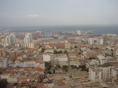
Position: Algiers lies on the western edge of the Bay of Algiers, a
crescent-shaped inlet of the Mediterranean Sea, framed by Cape Matifou
to the east and the Pointe Pescade promontory to the west.
Regional
Context: It’s located in northern Algeria, roughly 430 km northeast of
Oran and 280 km west of Constantine, within the Mitidja Plain, a fertile
coastal plain bordered by the Tell Atlas Mountains to the south.
Coastal Features:
Algiers stretches along a 16-km arc of
coastline, with a prominent waterfront known as the Corniche. The coast
features sandy beaches (e.g., Zeralda and Sidi Fredj), rocky cliffs, and
small coves.
The Bay of Algiers provides a natural harbor,
historically vital for trade and defense, making Algiers a key
Mediterranean port since Phoenician times.
Offshore, small islands
like the Îles Habibas (about 80 km west) and other rocky outcrops add to
the coastal character, though they’re not heavily developed.
Hills and Topography:
Algiers is famously built on a series of hills,
earning comparisons to Lisbon or San Francisco. The city rises from sea
level to about 400 meters at its highest points, creating a dramatic,
tiered urban landscape.
The Sahel Hills, a low ridge of the Tell
Atlas, run parallel to the coast behind the city, shaping neighborhoods
like El Madania and Bouzaréah. These hills give Algiers its
amphitheater-like layout, with buildings cascading toward the sea.
Key elevated points include the Casbah (at about 120 meters above sea
level) and the site of Notre-Dame d’Afrique (124 meters), offering
panoramic views of the bay.
The city divides into distinct zones: the historic Casbah (old city)
near the port, colonial-era downtown with wide boulevards like Didouche
Mourad, and modern suburbs like Bab Ezzouar and Hydra sprawling eastward
and southward.
The port, one of North Africa’s largest, occupies the
northern edge, handling commerce and passenger ferries to Europe.
Algiers’ footprint covers about 360 km², including metropolitan areas,
with a mix of dense urban cores and greener outskirts.
Type: Mediterranean (Köppen classification: Csa), characterized by
mild, wet winters and hot, dry summers.
Temperature:
Summer
(June–August): Averages 25–30°C (77–86°F), with highs occasionally
hitting 35°C (95°F). Sea breezes keep it bearable.
Winter
(December–February): Averages 10–15°C (50–59°F), with lows rarely below
5°C (41°F).
Precipitation:
Annual rainfall is about 600–700 mm
(24–28 inches), mostly falling between October and March. Winter storms
can bring heavy rain, occasionally causing flooding in low-lying areas.
Summers are nearly rainless, with clear skies dominating.
Other
Factors:
Humidity averages 70–80% due to the coastal location, higher
in winter.
Winds, like the sirocco (a hot, dusty wind from the
Sahara), can occasionally sweep through, especially in spring or autumn.
Rivers and Waterways:
Algiers lacks major rivers, but small
seasonal streams (wadis) like Oued El Harrach flow through the city,
often dry in summer. The Harrach River, east of the city, supports
agriculture in the Mitidja Plain but is prone to pollution.
Underground springs historically supplied the Casbah, reflected in place
names like Hamma (“fever” in Arabic, linked to thermal waters).
The surrounding Mitidja Plain is fertile, supporting olive groves,
citrus orchards, and vineyards, though urban expansion has reduced
farmland.
Coastal areas feature Mediterranean flora like Aleppo
pines, carob trees, and maquis shrubland. Gardens like the Jardin
d’Essai du Hamma showcase diverse plant life.
Hillsides are dotted
with eucalyptus and cypress, introduced during French colonial times for
erosion control.
Algiers sits on a tectonically active zone along the African-Eurasian
plate boundary, making it prone to earthquakes. The Tell Atlas region
has experienced significant quakes, like the 2003 Boumerdès earthquake
(6.8 magnitude), which impacted Algiers.
The city’s bedrock includes
sedimentary limestone and sandstone, with clay-rich soils in the plains,
influencing construction and landslide risks during heavy rains.
Urban Expansion: Algiers’ population (about 3.5–4 million in the
metro area) has driven sprawl into the hills and plain, leading to
challenges like traffic congestion and informal settlements.
Coastal
Development: The port and corniche are central to economic life, but
sea-level rise and erosion pose long-term threats. Projects like the
Great Mosque of Algiers, built on reclaimed land, reflect ambitious
coastal engineering.
Environmental Issues: Air pollution from
vehicles and industry, plus waste management in dense areas like the
Casbah, are ongoing concerns. Efforts to preserve green spaces, like the
Hamma Test Garden, aim to balance growth with nature.
The Casbah: Built on a steep slope above the port, its elevated
position made it defensible and central to Algiers’ early growth.
Bouzaréah Hill: At 345 meters, one of the highest points, home to
observatories and elite neighborhoods with sweeping views.
Pointe
Pescade: A western promontory with cliffs and beaches, popular for
fishing and leisure.
Mitidja Plain: South of the city, a breadbasket
for Algiers, though increasingly urbanized.
Why It Matters
Algiers’ geography—its sheltered bay, hilly backdrop, and Mediterranean
climate—has shaped it into a strategic and cultural hub for centuries,
from Berber settlements to Ottoman rule and French colonization. The
interplay of sea, hills, and plain creates a visually stunning city but
also challenges like seismic risks and urban density. Whether you’re
exploring the Casbah’s slopes or the waterfront’s breeze, the landscape
defines Algiers’ identity as much as its people do.