Location: 70 km South of Luanda Map
Area: 9,960 km²
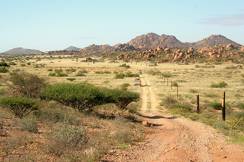
Iona National Park (Parque Nacional do Iona), established in 1937 as a reserve and upgraded to a national park in 1964, is Angola's largest and oldest protected area, spanning 15,150 square kilometers in the southwestern corner of Namibe Province. It borders the Atlantic Ocean to the west, with the Curoca River marking its northern boundary and the Cunene River its southern limit, extending about 200 kilometers south of the city of Namibe. The park forms part of the northern Namib Desert, also known as the Kaokoveld Desert, one of the world's oldest deserts at 55-80 million years old, and is contiguous with Namibia's Skeleton Coast National Park and Namib-Naukluft National Park, creating a vast transfrontier conservation area of approximately 50,000 square kilometers. Managed since 2019 by African Parks in partnership with the Angolan government, Iona has been recovering from decades of conflict during the Angolan Civil War (1975-2002), which led to severe poaching, infrastructure destruction, and biodiversity loss. Today, it employs around 135 staff and focuses on rehabilitation, community engagement, and ecotourism to promote sustainable development while preserving its unique desert and coastal ecosystems.
Boundaries and Overall Layout
The park is naturally
delimited by:
West: The Atlantic Ocean, with a dramatic ~160–200 km
shoreline that includes steep sea cliffs (10–100 m high), uplifted
coastal platforms, the Baía dos Tigres (Tiger Bay) lagoon system, an
extensive sand spit, and the mouth of the Cunene River.
East: The
Great Escarpment, which rises sharply and marks the transition to
Angola’s interior plateau; this includes rugged granite massifs such as
the Serra Tchamalindi (or Tchamaline/Tchamalinde) and Cafema mountains.
North: The intermittent Curoca River (with associated lagoons).
South: The permanent Cunene (Kunene) River, which forms the border with
Namibia and creates marshy wetlands at its Atlantic mouth.
This
east-west gradient—from hyper-arid coast to slightly less arid
escarpment foothills—defines the park’s geography.
Topography and
Major Landforms
Iona’s landscape is highly varied and iconic of the
northern Namib, characterized by three primary physiographic zones that
create a striking progression inland:
Coastal Zone (Western Strip):
Dominated by mobile red-orange sand dunes (ergs) that can extend up to
60 km inland in places. These shifting dunes meet the Atlantic along a
shipwreck-strewn coastline (earning the broader region the “Skeleton
Coast” moniker due to fog-induced maritime disasters and marine mammal
remains). The coast features steep cliffs, uplifted platforms, and sandy
beaches interspersed with rocky outcrops.
Central Zone (Gravel
and Calcrete Plains): Vast, open gravel plains (often calcrete-covered)
and flat expanses stretch across the park’s heart. These are punctuated
by ephemeral riverbeds (prehistoric drainage lines) that carve linear
corridors through the terrain. Inselbergs, mesas, and isolated granite
outcrops rise dramatically from the plains, creating “rock islands” with
hollows and small seasonal pools.Vegetation here is sparse but includes
iconic Welwitschia mirabilis—a ancient, fog-dependent plant that can
live over 1,000 years and is especially dense in Iona.
Eastern
Mountainous Zone: The terrain rises toward the Great Escarpment, with
rugged granite peaks (Serra Tchamalindi and Cafema) exceeding 2,000 m in
elevation in some descriptions (though park averages reach ~800 m at
interior posts like Posto do Iona). These mountains feature steep
cliffs, ridgelines, and dramatic escarpment faces. The gradient creates
panoramic views where dunes and plains give way to highland savanna-like
transitions.
Four main ecological-geographic zones are often
described (based on satellite and field studies): coastal desert, dune
sea, central gravel plains, and eastern mountainous/shrubland areas.
This creates a mosaic of habitats shaped by aridity, wind, and rare
water flows.
Elevation ranges from sea level on the coast to over
2,000 m at the eastern escarpment peaks, with a clear west-to-east
uplift.
Climate and Hydrological Features
Iona experiences a
hot desert climate (BWh in the Köppen-Geiger classification), driven by
the subtropical high-pressure belt and the cold Benguela Current
offshore. This current creates persistent coastal fogs and low stratus
clouds (especially June–September), which provide critical moisture via
dew and fog drip despite extreme aridity.
Rainfall: Highly
variable and low—~100 mm (or less) annually near the coast, increasing
to 300–450 mm (or up to ~500 mm in some interior reports) on the eastern
boundary. Most precipitation falls in brief summer showers
(January–March); some years see near-zero rain in hyper-arid coastal
strips.
Temperatures: Hot summers (October–May) with daytime highs up
to 40°C; cooler, foggy winters with coastal lows around 15–18°C.
Hydrology: Surface water is scarce and mostly ephemeral. The Cunene
River is perennial and supports wetlands at its mouth; the Curoca is
intermittent with lagoons. Internal drainage lines activate only after
rare floods, creating temporary oases. Fog moisture is the primary water
source for much of the biota.
These conditions produce one of the
world’s most extreme arid environments, yet the fog and rainfall
gradient support specialized, fog-dependent ecosystems.
Geological and Broader Context
The park sits on ancient Precambrian
bedrock (granites and other formations) sculpted over millions of years
by wind, rare floods, and tectonic uplift along the escarpment. The
Namib’s age and isolation have produced high endemism in flora and fauna
adapted to dunes, plains, and mountains. Soils are predominantly sandy
or gravelly with low organic content, except in ephemeral river
corridors.
The park's flora reflects its position in the Kaokoveld Centre of Endemism, with 234 indigenous woody species, 32 of which are endemic (14 percent), spanning Karoo-Namib, Zambezian, and Kalahari-Highveld floristic regions. Dominant vegetation types include sub-coastal steppes with Acacia, Commiphora, Colophospermum, Aristida, Schmidtia, and Stipagrostis species; coastal steppes with sub-desert plants like Aristida, Cissus, Salvadora, and Welwitschia; and desert dunes with Odyssea and Sporobolus grasses. Flagship species include the iconic Welwitschia mirabilis, a "living fossil" over 100 million years old that absorbs fog moisture, with populations geographically and genetically separated, some individuals exceeding 1,000 years. Other notables are Lithops ruschiorum (stone plant with horticultural value), Adenia pechuelii (elephant's foot), Cyphostemma species, Sterculia quinqueloba (white-stem tree), baobab (Adansonia digitata), Pachypodium lealii, Euphorbia eduardoi (Kaoko tree euphorbia), nara (Acanthosicyos horridus), Boscia microphylla, and recent discoveries like Crassothonna agaatbergensis and Euphorbia rimireptans. Climate-sensitive indicators include Portulacaria longipenduculata, Euphorbia otjingandu, and Sesamothamnus leistneri, showing drought distress. Riverine areas feature dense riparian woodlands, while Mopane shrublands are dominated by Colophospermum mopane, and coastal hummocks host pioneer species like Tetraena stapffii (dollar bush) and Arthraerua leubnitziae (pencil bush). Vegetation changes from 1990 to 2023 show increases in Vachellia and Mopane shrublands but declines in vegetated dunes and marshes, linked to drought and human pressures.
Iona's fauna is adapted to arid conditions, with high endemism, particularly among reptiles and insects. Mammals include viable populations of gemsbok (oryx gazella, around 1,650 individuals), springbok (Antidorcas marsupialis, about 2,400), Hartmann's mountain zebra (Equus zebra hartmannae, 265 adults with threats from hybridization creating "zonkeys"), greater kudu (Tragelaphus strepsiceros), black-faced impala (Aepyceros melampus petersi), and recently reintroduced Angolan giraffe (Giraffa giraffa angolensis, 14 individuals in 2023, with plans for more). Carnivores feature South African cheetah (Acinonyx jubatus, density 0.61 per 100 square kilometers), leopard (Panthera pardus), brown hyena (Parahyaena brunnea), black-backed jackal (Canis mesomelas), caracal, aardwolf, and chacma baboon. Marine mammals include Cape fur seals (Arctocephalus pusillus, over 15,000 at Baia dos Tigres) and dolphins like Tursiops truncatus and Cephalorhynchus heavisidii. Avifauna totals around 250 species, with 114 recorded in 2001 (58 waterbirds) and recent surveys noting 55,000 Cape cormorants; the Cunene River mouth is a key wetland for migrants like greater flamingos, pelicans, and ostriches (about 400 individuals). Reptiles and amphibians number 75 species (40 new records in 2022), with 63 reptiles in the ecoregion including eight endemics (two lizards, three geckos, three skinks); the Kunene hosts Nile soft-shelled turtles, marine green turtles, and crocodiles. Insects exceed 8,064 species (121 endemic, 94 threatened), with coastal beetles like Onymacris marginipennis and Onychosis gracilipes; at least five endemic fish species occur in the Kunene. Microbial diversity includes over 35 bacterial phyla (e.g., Actinobacteria, Proteobacteria) and fungal communities dominated by Ascomycota and Basidiomycota in hyper-arid soils. Historical species like black rhino, elephant, and lion were eradicated during the war, but reintroduction feasibility is under study.
As part of the Iona-Skeleton Coast Transfrontier
Conservation Area established in 2018, one of Africa's largest, Iona is
an Important Bird Area and lies within the Karoo-Namib center of
endemism, with efforts focused on integrated ecosystem management.
Conservation strategies include wildlife reintroductions (e.g., giraffes
in 2023), habitat mapping, aerial surveys, camera traps, telemetry, and
community-based monitoring with 21 trained para-ecologists using tools
like EpiCollect and WAR apps. Infrastructure rehabilitation, such as
staff housing, roads, and sustainable water/waste systems, supports
operations, alongside national efforts to strengthen the Instituto
Nacional de Biodiversidade e Áreas de Conservação. Cross-border
collaboration with Namibia addresses marine areas like the Namibe
Ecologically and Biologically Significant Marine Area, restricting
resource extraction. Earth observation data aids in land cover
classification (92-94% accuracy) and landscape metrics, informing land
use plans for restoration and grazing.
Threats include poaching,
overgrazing by livestock (estimated 14,000 cattle, 27,500 goats in
2003), deforestation for fuel, illegal settlements (population grew from
300 in 1974 to 3,500 in 2011), human-wildlife conflict (e.g., livestock
predation by cheetahs, crocodiles causing losses), invasive species like
Nicotiana glauca and Ricinus communis along rivers, habitat
fragmentation, and unregulated access via roads. Climate change
exacerbates issues with rising temperatures, variable rainfall, and
uncertain fog impacts, leading to land degradation (e.g., perennial
grasses replaced by annuals) and biodiversity loss, as seen in a 2014
drought causing 22% wildlife and 91% livestock declines. Potential
hydropower on the Kunene River threatens riparian ecosystems.
Colonial-Era Establishment (1930s–1960s)
The park’s formal history
begins during Portuguese colonial rule. On 2 October 1937, the area was
proclaimed a game reserve as part of early colonial efforts to protect
wildlife in Angola. It was upgraded to full national park status on 26
December 1964 and named after the commune of Iona (a small settlement
within its boundaries). At the time, Iona was already recognized as
Angola’s oldest protected area and one of the country’s premier wildlife
destinations.
Before the wars, Iona earned a reputation as an “animal
paradise” teeming with big game. Large populations of elephants, black
rhinos, and other megafauna roamed the dunes, plains, and escarpment
zones alongside oryx, springbok, zebras, and predators. The park’s
unique desert-adapted biodiversity—including endemic reptiles,
fog-dependent flora, and migratory seabirds—made it ecologically
exceptional even then.
Local semi-nomadic communities (primarily
Himba, Herero, Mucubal, and Mucahona groups, culturally related to
Namibia’s Himba) had long inhabited the region, practicing traditional
pastoralism alongside the wildlife. The 1937 reserve and 1964 park
designation began formalizing boundaries, though enforcement was limited
in this remote, arid frontier.
Devastation During the Wars
(1961–2002)
Angola’s struggle for independence (1961–1974) and the
subsequent Angolan Civil War (1975–2002) inflicted severe damage on
Iona, as they did on most of the country’s protected areas. Decades of
conflict, combined with a complete breakdown in law enforcement and
infrastructure, led to rampant poaching and habitat degradation. Iconic
species such as black rhinos and elephants were driven to local
extinction; other large mammals suffered drastic declines.
Communities fled across the border into Namibia to escape violence,
leaving the park largely abandoned. Physical remnants of this turbulent
era still dot the landscape today:
Ancient rhino rubbing stones
in the eastern plains (silent witnesses to the lost rhino population).
A rusted, broken-down Ford Fairlane sedan abandoned on the gravel plains
in the early 1970s by a Portuguese couple fleeing to Namibia.
By
the end of the civil war in 2002, Iona’s once-rich wildlife had been
reduced to remnant populations of mountain zebra, oryx, springbok,
cheetah, leopard, and brown hyaena. Infrastructure (roads, fences, water
points) lay in ruins, and the park was effectively unmanaged for nearly
four decades.
Post-War Recovery and Rehabilitation (2002–2019)
Peace in 2002 allowed displaced communities to begin returning. Early
recovery efforts were modest, with the first organized tourism visits
(mainly from Namibia) starting around 2001. From 2009 to 2019, a major
multinational program led by the United Nations Development Programme
(UNDP), in partnership with Angola’s Ministry of Environment (MINAMB),
focused on rebuilding the park. Initiatives included staff training,
infrastructure repairs (fencing, roads, water supply, waste management),
and the development of management plans.
A pivotal step came in 2018
with the creation of the Iona–Skeleton Coast Transfrontier Conservation
Area (TFCA), one of Africa’s largest, to enable cross-border
conservation monitoring and wildlife connectivity.
By this period,
some species had shown natural recovery (e.g., the first confirmed
sighting of South African cheetahs in 2010), but large-scale restoration
remained a challenge due to ongoing human–wildlife pressures from
returning livestock herders.
Modern Era: African Parks
Partnership and Rewilding (2019–Present)
In December 2019, the
Angolan government signed a 20-year co-management agreement with the
nonprofit organization African Parks. The official handover occurred on
31 January 2020. African Parks now manages the park in partnership with
MINAMB and the National Institute of Biodiversity and Conservation
(INBC), operating under five pillars: tourism, community engagement, law
enforcement, conservation science, and infrastructure development.
Key recent milestones include:
Community-focused work:
Development of a participatory Land Use Plan respecting traditional
Himba rights; training of local wildlife monitors (21 Himba community
members in 2022); education and socio-economic programs reaching over
17,000 people; conflict mitigation to reduce livestock predation and
retaliatory poisoning of carnivores.
Species reintroductions and
restoration: In July 2023, 14 Angolan giraffes (Giraffa giraffa
angolensis)—locally extinct in Angola since the 1990s and regionally
since the 1940s—were translocated from Namibia after a 36-hour journey.
A second group of 13 followed in May 2024. Monitoring continues, with
plans for further reintroductions (black rhino, lion, and possibly
elephant are under feasibility study).
Biodiversity surveys: A 2022
herpetofauna survey recorded 75 amphibian and reptile species (40 new to
the park); a 2023 coastal survey counted ~55,000 Cape cormorants. Bird
species now number around 250.
Tourism and infrastructure: New gates
(e.g., Ponto Albino), roads, and water points are being developed to
support low-impact tourism while generating revenue for conservation.
As of 2024, the park employs 135 staff and supports viable
populations of zebra, oryx, and springbok, alongside remnant predators.
Challenges persist—human and livestock population growth, low rainfall,
and climate pressures—but the park is steadily transforming from a
war-scarred landscape into a flagship for Angolan conservation.
Semi-nomadic pastoralist communities, including Himba, Herero, Muhimba, Mucubal, Mucahona, and Ovahimba (population about 3,500), engage in subsistence agriculture, livestock herding, and resource use, facing challenges like water scarcity (average household income $155) and conflicts over land for grazing. Conservation integrates community participation through participatory mapping, wildlife monitoring training, and alternative livelihoods like employment in the park (>10 direct jobs targeted) to reduce pressures. Tourism is emerging, with activities including coastal drives from Ponto Albino Gate through dunes and marshes, wildlife viewing (oryx, seals, flamingos), exploring shipwrecks and historical sites like abandoned sardine factories, birdwatching, and camping under star-filled skies. Guided by park staff, visitors navigate challenging terrains, observe whale migrations, and reflect on the park's resilience, with potential for sustainable growth balancing conservation and local benefits.