Location: 70 km from Luanda Map
Area: 9,960 km²
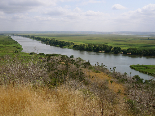
Quicama National Park is about 70 km from country's capital of Luanda and covers approximately 9,960 km² in North- west Angola. It protects an area of wetlands along with grasslands that is full of large animals. Quicama National Park was originally found as a game reserve in 1938 under Portuguese authorities with subsequent transfer to a status of a national park in 1957. After the Civil War the park is still devastated by the hostile actions in the regions. It is unclear how many buffalo, rhinos and elephants are left in the park since many of them were killed by humans. It is also unclear of level of hostility that is present among tribes dwelling in the nature reserve. It is not advisable to venture into park by yourself without guide or any representative of the local authority. The park is covered by open savanna with impressive baobab trees, dense forests as well as flood plains around Cuanza river.
Location and Size
The park lies in Bengo Province (sometimes
associated with Luanda Province in older references), roughly 70–75 km
south of Angola’s capital, Luanda. Its central coordinates are
approximately 9°45′S 13°35′E. It covers about 9,960 km² (roughly 3,850
sq mi or 3 million acres in some descriptions), making it larger than
many small countries and comparable in scale to the U.S. state of
Connecticut. This vast area stretches inland from the Atlantic seaboard.
Boundaries and Overall Layout
The park is clearly delimited on
three sides by major natural features:
West: A 110–120 km stretch of
the Atlantic Ocean coastline, including beaches, dunes, and estuarine
zones.
North: The Cuanza (Kwanza) River, one of Angola’s longest and
most important waterways. Its wide estuary and floodplain form the
northwestern boundary.
South: The Longa River, which creates a
similar riverine border.
The eastern edge transitions gradually
into higher thickets and the interior Angolan plateau, without a sharp
natural boundary. This configuration creates a long, roughly rectangular
park oriented northwest–southeast, with the coastal strip giving way
eastward to increasingly arid inland savanna.
Topography and
Landforms
Elevation ranges from sea level (0 m) along the coast to a
maximum of about 150 m on the inland plateau—relatively low-lying
overall, which contributes to extensive flooding and wetland formation.
Key landforms include:
Coastal zone: Sandy beaches, coastal dunes
shaped by Atlantic winds, and occasional cliffs or escarpments
(especially dramatic overlooking the Cuanza River). Mangrove networks
and lagoons punctuate the shoreline.
Riverine and floodplain areas:
Broad, seasonally inundated flats along the Cuanza and Longa, featuring
oxbow lakes, sandbars, and shallow depressions (pans) that fill during
rains.
Inland plateau and savanna: Gently undulating grasslands on a
low plateau, interrupted by scattered woodlands and dense thickets.
Escarpments and low ridges appear near the rivers, while the far east
becomes drier and more shrub-dominated.
The terrain is generally
accessible but includes rough tracks, seasonal streams, and thick brush
in places—features that historically made large-scale traversal
challenging.
Hydrology and Water Features
Water is the
defining geographic element. The Cuanza River dominates the north, with
its estuary hosting extensive mangroves (the southernmost major stand in
Angola), dense raffia-palm (Raphia) communities on waterlogged islands,
lowland riverine forests, reedbeds, swamps, papyrus (Cyperus) stands,
and grassy floodplains. The Longa River mirrors this to the south on a
smaller scale. Inland, seasonal streams and pans create temporary
wetlands during the wet season, while permanent water sources
concentrate wildlife in the dry months. The Atlantic influence moderates
salinity in coastal wetlands and supports marine–terrestrial transitions
(estuaries, sandbars, and lagoons).
Climate
Quiçama has a warm
tropical-to-semi-arid climate strongly influenced by the cold Benguela
Current of the Atlantic and the interior savanna systems. Year-round
temperatures average 22–32 °C, with occasional inland highs above 35 °C.
Rainfall is markedly seasonal and somewhat irregular: the wet season
(November–April) brings most precipitation, greening the landscape,
replenishing wetlands, and triggering flooding; the dry season
(May–October) is cooler, less humid, and ideal for wildlife viewing
around permanent rivers and pans. Annual rainfall typically falls in the
400–700 mm range, supporting a savanna rather than dense rainforest
environment.
Vegetation and Ecosystem Mosaic
The park’s
geography supports a rich mosaic of habitats (historically mapped into
nearly 30 vegetation communities). Key types include:
Coastal and
mangrove: Mangroves, coastal thickets, and dune vegetation.
Riverine/gallery forests and wetlands: Lush riparian forests, raffia
palms, papyrus swamps, reedbeds, and flooded grassy patches along the
Cuanza and Longa.
Savanna and grassland: Extensive open grasslands on
the plateau, dotted with palms and seasonal flowering species.
Woodlands and thickets: Iconic baobab (Adansonia)–acacia (Acacia) dry
woodlands in the east, patches of broadleaved woodland, and dense shrub
thickets (including species like Chrysobalanus, Drepanocarpus,
Dalbergia, Leguncularia, and Hibiscus). Cacti and succulent elements
appear in drier spots.
Roughly 55 % grassland, 24 % shrubland,
and 18 % forest cover the park overall. This diversity—from
mangrove-lined estuaries to baobab-studded savanna—arises directly from
the gradient between oceanic moisture, river flooding, and inland
aridity.
Colonial Origins (1938–1974)
The park’s formal history begins in
the late Portuguese colonial period. On 16 April 1938, the area was
declared a game reserve (reserva de caça) under the colonial
administration of the Overseas Province of Angola, primarily to regulate
hunting and protect abundant large game for sport and scientific
purposes. This was typical of colonial conservation in Africa, where
reserves often prioritized European hunters while restricting or
displacing local use.
On 11 April 1957 (some sources cite January
1957 or 1958), it was upgraded to full national park status to safeguard
diverse ecosystems along the coast and river floodplains. Pre-war
wildlife was legendary: estimates from the 1960s–early 1970s included
around 800 elephants, 3,000 African forest buffalo (pacaças),
populations of the iconic giant sable antelope (Hippotragus niger
variani, Angola’s national symbol), and other species such as lions,
leopards, and various antelopes. The park was one of Africa’s notable
wildlife strongholds at the time.
However, even before independence,
the park was never pristine. By the early 1970s, biologist Brian
Huntley’s surveys documented significant human pressures inside its
boundaries: illegal hunting, a private cattle-ranching operation with
over 25,000 head of cattle, thousands of hectares of cotton fields,
active oil production by two companies, diamond prospecting, a military
detention barracks, and a resident indigenous population of more than
5,000 people. These activities already strained habitats and wildlife.
The Angolan Civil War and Collapse (1975–2002)
Angola gained
independence from Portugal in 1975, but the country immediately plunged
into a devastating civil war (1975–2002) between the MPLA government,
UNITA rebels, and other factions. The 27-year conflict killed hundreds
of thousands, displaced millions, and destroyed two-thirds of the
country’s infrastructure. Quiçama National Park suffered catastrophic
damage.
Soldiers and displaced civilians turned to the park for
bushmeat; elephants, buffalo, and antelopes were slaughtered en masse.
Infrastructure (roads, camps, ranger posts) was abandoned or destroyed.
By the war’s end, the park’s large-mammal populations were virtually
eliminated—giant sable antelope disappeared from the park entirely (only
200–400 remain elsewhere in Angola today), and most other species were
reduced to remnant or locally extinct levels. Of Angola’s six
colonial-era national parks, Quiçama was the only one that remained
nominally operational, but in practice it was a ghost of its former
self, overrun by poaching and encroachment.
Post-War Revival and
the Kissama Foundation (1996–Present)
Peace arrived with the 2002
ceasefire. Rehabilitation began earlier through private initiative. In
1996, a group of Angolan and South African conservationists founded the
Kissama Foundation (Fundação Kissama) with the explicit goal of
protecting and restoring Angolan fauna and flora. Led by figures such as
Wouter van Hoven, the foundation partnered with the Angolan government
and international organizations.
The flagship effort was Operation
Noah’s Ark, launched in earnest around 2000–2001—widely described as the
largest wildlife translocation in history at the time. Animals were
sourced from overpopulated reserves in South Africa and Botswana and
moved to a fenced “soft-release” sanctuary (initially ~10,000–13,000
hectares) in the northern part of the park:
September 2000: 16
elephants airlifted from South Africa in Russian cargo planes (a
pioneering operation).
2001: Additional elephants (total ~28 in early
phases), 12 zebras, 12 ostriches, 14 wildebeest, 4 giraffes, and later
more species including oryx, eland, and others—roughly 150–200 animals
overall in the first waves.
A larger 2003 phase (originally planned
via South African Navy ship from Walvis Bay) brought further elephants
and antelopes.
The reintroduced animals adapted well, and
populations have grown steadily. The foundation also trained former
combatants as rangers, built basic camps (e.g., Kawa Camp/Sanctuary),
and began community-outreach programs. President José Eduardo dos Santos
officially reopened the park to visitors around 2000.
Recent
Developments and Ongoing Challenges (2002–2026)
Since 2002, Quiçama
has been the focal point of Angola’s wildlife recovery narrative. It was
designated a Lion Conservation Unit in 2005. Ecotourism has grown
modestly—day trips from Luanda are popular for coastal scenery,
baobab-dotted savannas, elephants, giraffes, and birdlife (flamingos,
pelicans, eagles, and many endemic species).
In 2025, the Quiçama
area (including the park and surrounding zones) was designated a UNESCO
Biosphere Reserve, recognizing its role in sustainable development,
community livelihoods, and biodiversity. The reserve now emphasizes
ecotourism, religious tourism at nearby Muxima, and coastal leisure
while aiming to balance conservation with local needs.
Challenges
persist. Between 2001 and 2013, nearly 7% of the park’s forest cover was
lost to charcoal production, firewood, illegal logging, and agriculture.
Poaching (especially for bushmeat) remains a top issue; the park has
reportedly led national poaching statistics in some years. Human
pressures—poverty-driven resource extraction, livestock grazing, shrimp
farms, palm-oil plantations, roads, and housing developments (e.g., Cabo
Ledo)—continue to fragment habitats. Experts emphasize the need for
stronger law enforcement, community benefit-sharing, and integrated
land-use planning.
The vegetation varies greatly from the banks of the Cuanza River to
the interior of the Park, with mangroves, dense forest, savannah,
scattered trees, cacti, baobab trees and large areas of trees.
The variety of vegetation results in an abundant and varied fauna. There
are African manatees (Trichechus senegalensis), red sables (Hippotragus
equinus), talapoins (Miopithecus talapoin) and sea turtles. There is
also a wide variety of birds.
Diversity in the species that we can find in this natural park, from elephants, giraffes, bambis, fan, turtles, snakes, wildebeests, crocodiles, springboks, hippos, zebras, manatees, various birds, squirrels, monkeys, among others.
The Basic Environmental Law (Law no. 5/98 of 5 June) states that Environmental Protection Areas “are well-defined spaces and representative of biomes or ecosystems that are interested in preserving, where exploration activities are not permitted. natural resources, except for use in ecological tourism, environmental education and scientific research. Environmental protection areas can have several classifications according to their scope and objective”. The designation National Park refers to an area reserved for the conservation, protection and propagation of endogenous fauna and flora, for public benefit and leisure. The Quiçama National Park (PNQ) was initially protected as a hunting reserve by Government Decree nº. 2620 of April 16, 1938 (Official Bulletin – I Series no. 16) and was then elevated to National Park by Legislative Diploma no. 2873 of December 11, 1957 (Official Bulletin – I Series no. 50).