Location: Northwest of Benin Map
Area: 2755 km²
Pendjari National Park (Parc National de la Pendjari, or PNP) in
northwestern Benin is one of West Africa’s most important remaining
intact savanna ecosystems. It forms a core component of the
transnational W-Arly-Pendjari (WAP) Complex, the largest protected
area block in the region spanning Benin, Burkina Faso, and Niger
(totaling over 1.7 million hectares in the core UNESCO site, with
broader landscapes exceeding 30,000–50,000 km² when including
buffers).
The park itself covers approximately 2,755 km²
(official core national park area per IUCN and Wikipedia data;
broader biosphere or managed zones under African Parks are sometimes
cited as 4,800–6,445 km² including adjacent hunting reserves and
buffers).
It is named after the Pendjari River, which forms part
of the northern boundary with Burkina Faso and creates vital
wetlands, floodplains, and gallery forests. The landscape features
Sudano-Sahelian savanna, grasslands, wooded savannas, rocky cliffs
of the Atakora range (visible from the park), and seasonal marshes
(mares) that concentrate wildlife. It is renowned for harboring some
of the last viable populations of West African lions (Panthera leo
leo), elephants, cheetahs, and other large mammals that have largely
disappeared elsewhere in the region.
Pre-colonial and Early Human Context (Pre-1920s)
Human presence in
the broader WAP landscape dates back tens of thousands of years. Traces
of prehistoric settlements (mounds, ceramics, iron metallurgy) exist,
though major population migrations likely occurred due to disease
epidemics or climate shifts. Long-term human use of fire—possibly for
50,000 years—has profoundly shaped the vegetation, creating and
maintaining the diverse mosaic of grasslands, shrublands, and savannas
that supports today’s biodiversity. Traditional fire regimes continue to
play a key ecological role.
Local communities (including groups in
the Atakora region) historically used the area for hunting, gathering,
transhumance (seasonal herding), and cultural practices, but the core
zone that became the park had relatively low permanent settlement
density even before formal protection.
Colonial Era:
Establishment as a Protected Hunting/Refuge Area (1920s–1960)
During
French colonial rule (Dahomey colony, now Benin), the area was initially
designated as a hunting zone reserved for colonial administrators and
officials. To create a wildlife refuge and later formal protected areas,
colonial authorities systematically relocated the few remaining
inhabitants between 1926 and 1954. This displacement aimed to eliminate
human activities (farming, herding, fishing, and traditional hunting)
that were seen as threats to big game.
Key milestones:
1954:
The former colonial hunting area was upgraded to Réserve partielle de
faune de la Boucle de la Pendjari (Partial Wildlife Reserve of the
Pendjari Bend).
1955: It became the Réserve totale de faune de la
Pendjari (Total Wildlife Reserve).
1959: Adjacent zones cynégétiques
(hunting zones) of Pendjari and Atacora were created to allow regulated
(often sport) hunting while buffering the core reserve.
These
steps reflected broader colonial conservation policies across French
West Africa, prioritizing wildlife for hunting and scientific interest
over local land rights.
Post-Independence: Formal National Park
Status and Early Management (1960s–1980s)
Benin gained independence
in 1960. In 1961, the reserve was officially designated Parc National de
la Pendjari, one of the country’s flagship protected areas. The 1959
hunting zones remained as buffers.
In the following decades,
management focused on anti-poaching and basic infrastructure, but
enforcement was limited. The park retained relatively high biodiversity
compared to many West African areas, thanks to its remoteness and the
Atakora hills acting as a natural barrier.
International
Recognition and Biosphere Status (1980s–2000s)
16 June 1986: UNESCO
designated the Pendjari area (including the national park, hunting
zones, and a buffer) as the Réserve de biosphère de la Pendjari (RBP)
under the Man and the Biosphere Programme. This emphasized integrated
conservation with local communities.
1996: Benin created the Centre
National de Gestion des Réserves de Faune (CENAGREF), a dedicated state
agency (with scientific, social, and cultural mandates) to manage
Pendjari and the neighboring W National Park sector. Village
associations (AVIGREF) were established to involve surrounding
communities in co-management.
2007: The Pendjari River valley was
designated a Ramsar Wetland of International Importance, highlighting
its hydrological and biodiversity value.
The Beninese portion of
the W complex (including Pendjari) contributed to the original W
National Park inscription on the UNESCO World Heritage List in 1996
(criteria ix and x for ecological processes and biodiversity).
Challenges and Decline (1990s–Early 2010s)
Despite legal protections,
the park faced mounting pressures:
Intense poaching (especially for
ivory, bushmeat, and lion parts).
Illegal grazing, agricultural
encroachment, tree felling, and resource extraction by growing local
populations.
Weak enforcement due to limited funding and
infrastructure.
Human-wildlife conflict and competition with
transhumant herders.
By the mid-2010s, multiple sources described
Pendjari as “dying a slow death,” with declining wildlife populations
(e.g., sharp drops in waterbuck and other species) and habitat
degradation. It was still one of West Africa’s least-damaged large
savanna parks but was under severe threat.
In March 2009, Benin
submitted a tentative UNESCO World Heritage nomination for Pendjari.
Revival and UNESCO World Heritage Extension (2017 Onward)
A
turning point came in May 2017 when the Government of Benin signed a
long-term public-private partnership with the conservation NGO African
Parks. This gave African Parks full management responsibility for
Pendjari (one of 45 flagship projects in Benin’s “Revealing Benin”
national development program launched in 2016). The goal was to restore
wildlife, combat poaching, develop responsible tourism, and deliver
community benefits.
July 2017: Pendjari was formally inscribed as
part of the transnational W-Arly-Pendjari Complex UNESCO World Heritage
extension (adding Benin’s Pendjari and Burkina Faso’s Arly to the
original 1996 W site; criteria ix and x). In 2020, the biosphere reserve
was expanded into the transboundary WAP Biosphere Reserve.
2018: A
major $23–23.5 million rehabilitation grant was secured from partners
including the Wyss Foundation, National Geographic, and Wildcat
Foundation.
Under African Parks (which employs hundreds of mostly
local staff, including rangers), the park has seen:
Increased law
enforcement and infrastructure (fencing, roads, viewing hides).
Wildlife recovery: Stabilizing or growing populations of elephants
(hundreds in Pendjari alone, part of the region’s largest ~2,800–3,800),
lions (~100 in the WAP, ~25% of the global West African lion
population), and other species.
Community programs: Environmental
education (reaching thousands of schoolchildren), income-generating
activities (beekeeping, agriculture), reforestation, and human-wildlife
conflict reduction (down ~70%).
Recent Developments and Ongoing
Challenges (2019–Present)
Security has been a major issue due to
jihadist spillover from Burkina Faso:
2019: The park was briefly
classified as a “red zone” after the kidnapping of two French tourists
nearby.
2022: An IED attack killed several African Parks personnel;
tourism was temporarily suspended for safety (it has since partially
resumed in safer periods).
Militant groups have used remote park
areas for resources, recruitment, and attacks, exacerbating tensions
with some local communities who historically view strict conservation as
a continuation of colonial exclusion.
Despite these threats,
Pendjari remains a conservation success story and the most actively
managed part of the WAP Complex. It serves as a vital refuge for
critically endangered species and a model for transboundary cooperation.
Tourism (safaris focused on big game, birds—~300–460 species—and scenic
landscapes) contributes to local economies when security allows, with
access via gates near Tanguiéta and viewing points at key waterholes
like Mare Bali.
Size, Boundaries, and Regional Context
The core national park
covers 2,755 km² (1,064 sq mi). Under management by African Parks (in
partnership with the Beninese government since 2017), the protected
landscape often referenced includes adjacent hunting zones and buffer
areas, bringing the effective management area to around 4,800 km² or
more (with the broader WAP Complex exceeding 26,000 km²). The park
adjoins Arli National Park in Burkina Faso along its northern edge and
includes a semi-protected southern “cynégétique” (hunting) zone. It is
bounded primarily by the Pendjari River to the north and east, creating
a natural demarcation.
Topography and Landforms
The park
occupies an extensive peneplain—a gently undulating, eroded flatland
typical of the Sudanian region—with predominantly flat to gently rolling
terrain at low elevations (generally 150–300 m above sea level, though
exact figures vary locally). This flat expanse is dramatically
interrupted to the west by the Atakora Mountains (also linked to the
Togo Mountains chain), whose rugged ridges, rocky inselbergs (isolated
hills or outcrops), cliffs, and escarpments rise prominently and are
visible across much of the park. These features create a series of
valleys, moderate elevation changes, and dramatic viewpoints overlooking
endless plains.
Rocky cliffs and outcrops, often composed of
quartzite or similar resistant rocks, dot the landscape and support
sparser vegetation due to shallow soils. In contrast, deeper soils on
some summits and along the Atakora escarpment allow for greater plant
diversity and more wooded cover. The overall terrain transitions
smoothly from open savanna plains (ideal for large grazers) to wooded
savannas, rocky highlands (refuges for species like leopards), and
riverine lowlands. This variety of landforms—sweeping grasslands,
dramatic escarpments, rocky inselbergs, and fertile floodplains—gives
the park its textured, visually striking character.
Hydrology and
Water Systems
The Pendjari River is the park’s namesake and
hydrological lifeline. It flows year-round (unlike many seasonal
watercourses in the region), forming the northern boundary with Burkina
Faso and sustaining wildlife through the long dry season. Gallery and
riparian forests line its banks, creating shaded corridors of denser
woodland. The river is part of the larger Volta River basin and has been
designated a Ramsar Wetland of International Importance (Site No. 1669)
for its role in supporting migratory birds and aquatic biodiversity.
Seasonal floodplains, oxbow lakes, lagoons, and channels branch off the
main river, especially during the wet season when rainfall causes
flooding and creates temporary wetlands. Depressions and tributaries
form natural pans and waterholes that fill with rain and gradually dry,
concentrating animals around shrinking water sources. These dynamic
systems—ebb and flow driven by the West African monsoon—produce a rich
mosaic of aquatic and semi-aquatic habitats critical for hippos,
crocodiles, waterbirds, and large mammals.
Climate
Pendjari
has a tropical savanna climate in the Sudanian bioclimatic zone,
characterized by two distinct seasons and annual rainfall of
approximately 1,100 mm (43 in). The wet season (roughly May/June to
October/November) brings heavy rains, lush vegetation, dramatic
thunderstorms, and occasional inaccessibility of tracks due to mud and
flooding. The dry season (November to April) features hot days (30–40 °C
/ 86–104 °F), cooler nights (especially December–February, with lows
around 18–22 °C / 64–72 °F), thinner vegetation, and peak wildlife
concentrations around permanent water. The park remains open year-round,
but the dry season offers the best visibility and game-viewing, while
the wet season highlights botanical diversity and birdlife.
Vegetation and Ecological Zones
The park supports a highly diverse
mosaic of Sudanian and Guinean savanna ecosystems, including grasslands,
shrublands, wooded savannas, open forests, and extensive
gallery/riparian forests. Vegetation patterns shift with soil depth,
topography, and proximity to water:
Open grasslands and floodplains —
dominated by species such as Acacia sieberiana, Mitragyna inermis, and
Terminalia macroptera; these are prime grazing areas.
Wooded savannas
— scattered with iconic trees like baobab (Adansonia digitata), shea
(Vitellaria paradoxa), acacia, and Combretum species.
Rocky cliffs
and outcrops — sparsely wooded with drought-resistant trees including
Burkea africana, Detarium microcarpum, Lannea acida, Sterculia setigera,
and Combretum ghasalense.
Deeper soils on escarpments and summits —
greater diversity, featuring Isoberlinia doka and Afzelia africana.
Riverine and gallery forests — dense, shaded corridors along the
Pendjari River and tributaries.
Rare semi-deciduous forest — the
Bondjagou forest patch within Pendjari stands out as an unusual moist
enclave amid the drier savanna matrix.
Fire (both natural and
managed) and the seasonal water cycle further shape this vegetation
mosaic, maintaining the open savanna character while allowing localized
forest patches. The result is one of West Africa’s most intact and
ecologically varied Sudano-Sahelian landscapes, supporting an
exceptional array of flora that underpins the park’s rich fauna.
Flora: Diverse Sudano-Sahelian Savanna Mosaic
Pendjari’s
vegetation is a classic example of intact West African savanna woodland,
with a high diversity and biomass of plants relative to the sub-region.
The Pendjari Biosphere Reserve (which encompasses the national park) has
been documented to contain 684 species of vascular plants
(Magnoliophyta) across 366 genera and 89 families. The most species-rich
families are Fabaceae (115 species) and Poaceae (grasses, dominant in
herbaceous layers).
Vegetation types form a rich mosaic shaped by
topography, soil depth, fire, and hydrology:
Grasslands and
herbaceous savannas: Dominated by species such as Acacia sieberiana,
Mitragyna inermis, and Terminalia macroptera. These open areas are vital
grazing grounds, especially during the wet season.
Wooded and shrubby
savannas: Common across much of the park, with scattered trees and
shrubs.
Open forests and dry forests: Include tree islands and more
closed-canopy patches.
Gallery and riparian forests: Dense, riverine
woodlands lining the Pendjari River and floodplains, providing corridors
and shade.
Rare semi-deciduous forest (e.g., Bondjagou forest within
Pendjari): A standout feature with higher moisture and species variety.
Rocky cliffs and Atakora escarpment: Sparsely wooded with
drought-tolerant species including Burkea africana, Detarium
microcarpum, Lannea acida, Sterculia setigera, and Combretum ghasalense.
Deeper soils on summits support greater diversity, notably Isoberlinia
doka and Afzelia africana.
Iconic large trees like baobabs
(Adansonia digitata) dot the landscape. Three plant species are endemic
to Benin: Ipomoea beninensis, Thunbergia atacorensis, and Cissus
kouandeensis.
Fauna: Refuge for West Africa’s Last Large Mammals
Pendjari supports over 50 large mammal species (73 total mammals
recorded in the WAP Complex), one of the highest biomasses of wild
ungulates remaining in West Africa. It is particularly important for
species that are regionally endangered or extinct elsewhere.
Large
Herbivores
African savanna elephants (Loxodonta africana):
Pendjari hosts the largest and most secure population in West Africa —
approximately 2,800 individuals in the park itself (part of ~3,800–4,000
across the WAP Complex), representing about 85% of the region’s
remaining savanna elephants. Numbers have increased in recent years
thanks to improved management.
Hippopotamus (Hippopotamus amphibius):
Abundant in the Pendjari River and pools; the park’s second-largest
mammal species.
African buffalo (Syncerus caffer brachyceros): Large
herds (historically ~2,700 in early counts).
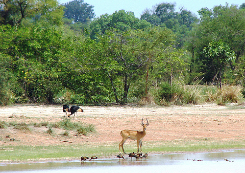
Antelopes (10+ species):
Roan antelope (Hippotragus equinus), Western hartebeest (Alcelaphus
buselaphus major), korrigum (topi subspecies, Damaliscus lunatus
korrigum), Buffon’s kob (Kobus kob), Defassa waterbuck (Kobus
ellipsiprymnus defassa), tsessebe, bushbuck, reedbuck, red-flanked
duiker, oribi, and common duiker. Some (e.g., korrigum, hartebeest) are
the focus of ongoing captive-breeding and reintroduction programs.
Warthog (Phacochoerus africanus): Common.
Carnivores and Other
Mammals
West African lion (Panthera leo leo): One of the last viable
populations; the WAP Complex holds ~90% of the subspecies’ remaining
individuals (~100 in the broader complex, with a key presence in
Pendjari). Critically endangered regionally.
Northwest African
cheetah (Acinonyx jubatus hecki): Extremely rare (possibly the only
remaining population in West Africa); very small numbers remain.
African leopard (Panthera pardus pardus), spotted and striped hyenas,
side-striped jackal, African civet.
African wild dog (Lycaon pictus
manguensis): Recorded but rare.
Primates: Olive baboon (Papio
anubis), patas monkey (Erythrocebus patas), tantalus monkey (Chlorocebus
tantalus).
African manatee (Trichechus senegalensis): Present in
river systems.
Birds
Pendjari is an Important Bird Area (IBA)
with 300–460+ recorded species (sources vary slightly by survey scope).
It supports resident, migratory, and waterbird populations, especially
during the dry season when animals concentrate at waterholes. Notable
species include:
Waterbirds and storks: African openbill, Abdim’s
stork, saddle-billed stork, African fish eagle, Pel’s fishing-owl.
Raptors: Martial eagle, pallid harrier, lesser kestrel, fox kestrel,
booted eagle, red-thighed sparrowhawk.
Others: Abyssinian roller,
bee-eaters, violet turaco, Senegal parrot, white-crowned robin-chat,
various chats, pytilias, waxbills, and paradise-whydahs.
Reptiles, Amphibians, and Fish
Reptiles: ~112–150 species in the
complex (including Nile crocodile in rivers and pools).
Fish: High
diversity (~120 species) with notable endemism; seven of the nine Volta
Basin endemics occur here, many in the Pendjari River and associated
wetlands (Nilo-Sudanian fauna, e.g., cyprinids, mormyrids).