Location: Map
Area: 15,000 km²
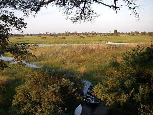
The Okavango Delta, also known as the Okavango Grassland, is a vast inland river delta in northern Botswana, renowned as one of the world's largest and most pristine wetland ecosystems. Formed where the Okavango River spreads out over the Kalahari Desert basin, it covers an area that fluctuates between 6,000 and 15,000 square kilometers depending on seasonal flooding, making it a unique endorheic delta that does not drain into any ocean but instead loses its water through evaporation and transpiration. This creates an oasis in an otherwise arid landscape, supporting extraordinary biodiversity and serving as a critical water source in southern Africa. Inscribed as a UNESCO World Heritage Site in 2014—the 1,000th site on the list—it is recognized for its outstanding natural beauty, ecological processes, and biological diversity. It was also voted one of the Seven Natural Wonders of Africa in 2013 and designated a Ramsar Wetland of International Importance in 1996. The delta attracts around 120,000 tourists annually, contributing significantly to Botswana's economy through eco-tourism, while also sustaining local communities. As of 2025, following years of drier conditions, the delta has experienced a robust annual inundation, restoring water levels and enhancing its vibrancy.
Location and Extent
The Delta lies in the Ngamiland District of
Botswana, roughly between 18°15'S to 20°45'S and 21°45'E to 23°53'E, at
elevations of 930–1,000 meters above sea level. It sits at the southern
end of the East African Rift Valley system, on the northern fringe of
the Kalahari Desert, bordered by Namibia to the northwest and the
Makgadikgadi Pans to the southeast.
The UNESCO World Heritage Site
core area covers 2,023,590 hectares (about 20,236 km²), with a buffer
zone of 2,286,630 ha. The active wetland fluctuates seasonally between
6,000 and 15,000 km² (roughly the size of Connecticut or half of
Massachusetts at peak flood). The broader alluvial fan, including drier
margins, can reach 40,000 km². Moremi Game Reserve occupies over a third
of the Delta.
Geological Formation and History
The Delta's
origins trace to tectonic activity in the East African Rift. Around
50,000–60,000 years ago (with some evidence pointing to earlier events
~18,000 years ago in the Holocene), earthquakes and faulting created a
tectonic trough (graben) that "captured" the Okavango River's flow.
Previously, the river fed the massive ancient Lake Makgadikgadi (which
covered over 100,000 km² and has since mostly dried into the
Makgadikgadi Pans). The blockage turned the river into an endorheic
system, fanning out into the desert instead of reaching the sea.
Geologically, it is a low-gradient alluvial fan built from sediments
(primarily Kalahari Group sands, silts, and clays up to 400m thick in
places) carried by the river. The fan rests in fault-bounded
depressions, with ongoing subtle tectonic influences shaping water
distribution. The underlying geology includes interbedded alluvium and
older bedrock, contributing to the Delta's porosity and groundwater
dynamics.
Hydrology and Water Dynamics
The Okavango River
(about 1,500 km long, the third-largest in southern Africa) originates
in the humid highlands of central Angola (Cuito and Cubango rivers).
Annual rainfall there (up to 1,300 mm) generates ~11 km³ of water that
travels 1,200 km over 4–7 months, peaking in Botswana's dry winter
(April–May arrival at Mohembo). Local rainfall in the Delta adds another
~6 km³ (450–600 mm annually, highly variable: 195–940 mm at Maun).
In
the Panhandle (northern section), the river flows as a single, deep,
confined channel with perennial papyrus swamps. At Seronga, it fans out
into a complex network of anastomosing (branching and rejoining)
channels, lagoons, oxbow lakes, and floodplains. Water spreads slowly
southward over the ultra-flat terrain (slope ~1:3400–1:5000),
infiltrating heavily into sandy soils (80–90% of floodwater). Most is
lost to evapotranspiration; only ~2% or less may reach Lake Ngami or
other outlets in wet years.
The Delta is highly dynamic: channels
shift over decades due to sediment buildup, vegetation blockages, and
hippo/elephant activity, causing floods to redirect and formerly wet
areas to dry (or vice versa). This creates immense habitat diversity on
timescales of decades to centuries.
Topography and Physical
Features
The Delta is exceptionally flat: less than 2 meters of
elevation variation across 15,000 km², with the water surface dropping
only ~60 m from Mohembo (northern inlet) to Maun (southern edge). This
low relief allows the flood to spread laterally up to 150 km wide.
Key features include:
Permanent swamps (~600,000 ha): Deep,
perennial wetlands in the north/central areas with papyrus, reeds, and
open water.
Seasonal floodplains (up to 1.2 million ha): Grasslands
that flood in winter and dry in summer.
Channels and waterways:
Meandering, free-flowing canals and lagoons.
Islands: Over 150,000,
ranging from tiny termite-mound origins to massive ones like Chief's
Island (larger than some cities). Islands form via fluvial processes
(scroll bars, inverted channels) or termite mounds. Trees on elevated
spots transpire groundwater, concentrating salts and precipitating
minerals (calcite, silica) that expand soil upward, growing the islands.
Salinity gradients create concentric vegetation zones; island centers
can become barren salt pans.
Aerial and satellite views reveal a
green "fan" of waterways and islands contrasting sharply with
surrounding tan desert sands.
Climate and Seasonal/Geographic
Interactions
The regional climate is semi-arid (high potential
evapotranspiration exceeds rainfall year-round), but the Delta's
hydrology is decoupled from local rains—floods arrive in the dry season,
sustaining lush growth when surrounding areas parch. This reverse
seasonality drives unique adaptations in vegetation and wildlife (e.g.,
grasses timed to winter floods).
The near-pristine state, minimal
human transformation, and ongoing geomorphological processes
(sedimentation, channel avulsion, island growth) make it a textbook
example of climatic-hydrological-biological interplay within an
endorheic basin.
Geological Formation: A Tectonic and Hydrological Marvel (Millions to
Tens of Thousands of Years Ago)
The Delta's origins trace back to the
breakup of the supercontinent Gondwana and the ongoing formation of the
East African Rift Valley system, which began influencing the region
around 140–130 million years ago but intensified with rifting about 2
million years ago. Tectonic activity created parallel fault lines
(including the Gumare, Linyanti, Kunyere, and Thamalakane faults) that
uplifted and collapsed land, forming a low-gradient graben (tectonic
trough) in the Kalahari Basin—the lowest point in the region at
930–1,000 meters elevation. This basin had been filling with sediments
for 65 million years from ancient rivers and wind-blown sands.
Prior
to the Delta's current form, the area was part of the vast prehistoric
Lake Makgadikgadi, a mega-lake that once covered over 100,000 km² of
Botswana's interior (with remnants visible today as the Makgadikgadi
salt pans). Rivers like the proto-Okavango, Kwando, Linyanti, Chobe, and
even the Upper Zambezi likely formed a single system draining eastward
to the Indian Ocean via the Limpopo. About 50,000–120,000 years ago
(with the current fan shape bounded by the Thamalakane fault dating to
roughly 120,000 years), massive earthquakes and tectonic uplift near the
Botswana-Namibia border blocked the river's southward or eastward path.
The Okavango River—originating 1,500 km away in Angola's highlands—was
"captured" and forced to spread across the flat trough, depositing
sediment and forming the alluvial fan. Over the last million years, the
Delta has fluctuated: shrinking to near-desert during dry phases and
expanding (sometimes merging channels into the mega-lake) during wetter
floods.
Today, 95%+ of the water comes from Angolan rainfall (peaking
in the dry Botswana winter, June–July), creating a "flood pulse" that
sustains the ecosystem. Channels shift constantly due to sediment
buildup, termite mounds, hippo paths, papyrus blockages, and ongoing
minor tectonics—making the Delta a living, evolving landscape rather
than a static feature.
Prehistoric Human Presence: Possible
Cradle of Modern Humanity (~200,000 Years Ago)
Genetic,
archaeological, linguistic, and climatic evidence points to the lush
wetlands of the ancient Okavango-Makgadikgadi region as a key ancestral
homeland for all living humans. A 2019 Nature study analyzed
mitochondrial DNA (the L0 lineage, the oldest known maternal line) from
southern African groups and correlated it with paleoclimate data,
arguing that a stable community of Khoisan hunter-gatherers thrived here
~200,000 years ago in a vast wetland the size of Switzerland. This group
persisted largely unchanged for ~70,000 years before climate shifts
(wetter corridors ~130,000 years ago, then drying ~110,000 years ago)
prompted migrations northeast and southwest across Africa—preceding the
major "out-of-Africa" dispersal 70,000–100,000 years ago.
The area’s
stable resources (fish, plants, game) supported this population during a
time when much of Africa was drier. While controversial (critics note
the study’s heavy reliance on mtDNA overlooks nuclear DNA and older
fossils like 315,000-year-old remains from Morocco, favoring a more
polycentric "African origins" model), it underscores the Delta’s long
role as a human refuge. Archaeological evidence confirms San
(Khoisan/Bushmen) presence in the broader Kalahari for at least
20,000–45,000 years (with genetic roots possibly 80,000+ years), as
hunter-gatherers.
Indigenous Peoples and Traditional Life
(Thousands of Years to Present)
The San (Bushmen)—including groups
like the ǁanikhwe (River/Swamp Bushmen) and Bugakhwe—were the first
documented inhabitants, living nomadically as hunter-gatherers adapted
to riverine and wetland resources (fishing, wild plants, game). Many
Delta islands still bear San names, reflecting their deep knowledge of
the landscape. They had minimal ecological impact due to low population
density and sustainable practices.
Over the past few centuries (and
earlier migrations), Bantu-speaking groups arrived: the Wayeyi (Bayei),
Hambukushu, Dceriku, and others practiced mixed economies of fishing,
millet/sorghum farming, hunting, gathering, and limited pastoralism.
These groups adapted culturally to specific niches (e.g., riverine vs.
floodplain). The Delta remained sparsely populated due to
inaccessibility, tsetse flies (which threatened cattle), and seasonal
flooding.
European Exploration and 19th-Century Shifts
Scottish missionary-explorer David Livingstone was the first known
European to reach the Delta in 1849 (noted in journals from 1848),
describing its "country full of rivers" and lush swamps. His accounts
sparked wider interest, but the area stayed remote.
In the late 18th
century, the Batawana (a Tswana subgroup and Bangwato offshoot, led by
the house of Mathiba I) gained political control over Ngamiland (the
Delta region). By the 1850s, they established dominance amid the booming
regional ivory trade, though most lived on the edges to avoid tsetse
flies. A temporary retreat of the flies allowed deeper settlement from
1896 to the late 1930s.
20th Century: Settlement, Wildlife
Pressures, and Early Conservation
Wildlife depletion from hunting and
ivory trade prompted local action. On 15 March 1963, the Batawana people
themselves proclaimed the Moremi Game Reserve on tribal land (one of
Africa’s first reserves created by indigenous communities, initiated by
the widow of Chief Moremi III). It initially covered the eastern Delta
and expanded in the 1970s to include Chief’s Island.
Botswana’s
independence in 1966 accelerated conservation. In the late 1960s–early
1970s, over 4,000 Hambukushu refugees from Angola settled in the western
panhandle (around Etsha). Veterinary fences (from the late 1950s)
controlled livestock diseases but fragmented wildlife migration. Floods
in 1974–1978 spurred the Molapo Development Project for flood control
and agriculture.
Modern Conservation, UNESCO Status, and
Contemporary Challenges (1990s–Present)
The Delta was designated a
Ramsar Wetland of International Importance in 1996. In 2014, it became
UNESCO’s 1,000th World Heritage Site (criteria vii, ix, x), recognizing
its pristine state, exceptional beauty, geomorphological processes, and
biodiversity. About 40% lies in Moremi Game Reserve; the rest in
community-managed Wildlife Management Areas. The Permanent Okavango
River Basin Commission (OKACOM) coordinates transboundary efforts with
Angola and Namibia.
Tourism is low-impact (air-accessed tented
camps), supporting community trusts and employing locals. Indigenous
groups (San and others) are increasingly integrated into management,
with recognition of traditional rights and benefits.
Ongoing threats
include:
Climate change (reduced rainfall, higher evaporation).
Upstream dams/irrigation in Angola/Namibia.
Oil/gas exploration
(e.g., ReconAfrica in the broader Kavango-Zambezi region since 2021).
Poaching (e.g., rhinos in 2020–2021).
Human encroachment and
livestock pressure.
The Okavango Delta is a biodiversity hotspot, hosting over 1,000 plant species, 480 bird species, 130 mammals, 71 fish, and numerous reptiles and amphibians. Flora includes 1,068 species from 134 families, dominated by miombo woodlands on the fringes, acacias, mopane trees, and wetland plants like papyrus, reeds (Phragmites australis), and water lilies in swamps. These plants play a crucial role in ecosystem engineering, such as forming salt islands through transpiration. Fauna features the "Big Five" (lion, leopard, elephant, buffalo, rhinoceros), with large herds of elephants (up to 200,000 regionally), giraffes, zebras, wildebeest, and antelopes like the semi-aquatic red lechwe (estimated at 88,000). Endangered species include cheetahs, African wild dogs, black and white rhinoceroses, and wattled cranes. Birdlife is prolific, with over 400 species including African fish eagles, pelicans, and migratory birds. Aquatic life comprises tigerfish, tilapia, and catfish, supporting a food web linked to historical connections with the Zambezi River. The delta's mosaic habitats foster high endemism and seasonal migrations, making it one of Africa's premier wildlife concentrations.
Conservation in the Okavango Delta emphasizes community involvement, transboundary cooperation, and sustainable tourism. The Moremi Game Reserve protects the eastern core, while the broader delta is managed under Botswana's wildlife policies, with 39% of the country's land designated as protected areas. Initiatives like the Okavango Wilderness Project by National Geographic focus on safeguarding the river basin from upstream threats in Angola. UNESCO and Ramsar frameworks guide management, with the 2025 State of Conservation Report highlighting ecological health monitoring and mitigation strategies. Community-based models, such as COMPACT, engage locals in governance, while anti-poaching patrols and habitat restoration address declines. Tourism revenues fund conservation, with lodges adopting low-impact practices like solar power and waste management. Transboundary efforts under the Permanent Okavango River Basin Water Commission (OKACOM) ensure water security across Angola, Botswana, and Namibia.
Despite its pristine status, the Okavango Delta faces escalating threats. Climate change has caused erratic flooding, with prolonged dry spells in recent years followed by heavy 2025 inflows, disrupting ecosystems and wildlife patterns. Upstream activities in Angola, including potential oil exploration, agriculture, and dam construction, pose risks of pollution and reduced water flow. Oil drilling threats have prompted UNESCO recommendations for expanded protections, while invasive species, poaching, overharvesting, and wildfires exacerbate vulnerabilities. Human-wildlife conflicts arise from expanding settlements, and tourism pressures, if unmanaged, could lead to habitat degradation. Biodiversity loss is evident in declining populations of species like wild dogs and cranes. Mitigation focuses on basin-wide monitoring and international advocacy to preserve this fragile system.
Tourism in the Okavango Delta revolves around immersive wildlife experiences, with activities including game drives, mokoro (dugout canoe) excursions, walking safaris, boat cruises, and aerial scenic flights. Luxury camps and lodges, often in private concessions, offer year-round access, with the northern delta providing consistent water-based adventures. Birdwatching, fishing, and cultural interactions with local communities enhance visits. Peak season aligns with high water levels (June–October) for optimal wildlife viewing. The delta's significance lies in its role as a life-sustaining wetland in a desert, supporting livelihoods for over 150,000 people through tourism and subsistence, generating economic value while exemplifying successful conservation-tourism integration. It symbolizes Botswana's commitment to biodiversity, contributing to global efforts in wetland preservation and climate resilience.