Location: West of Gaoua Map
Area: 11,130m2
Loropéni is a small market town in southern Burkina Faso, best known for the ancient Ruins of Loropéni, a UNESCO World Heritage Site inscribed in 2009 as the country's first such designation. The ruins represent a well-preserved medieval fortified settlement spanning approximately 11,130 square meters (2.75 acres), with a surrounding buffer zone of about 2.784 square kilometers (1.1 square miles). Situated in the Poni Province of the Sud-Ouest Region, the site is emblematic of West Africa's historical involvement in the trans-Saharan gold trade, serving as a testament to the economic and cultural power of ancient regional kingdoms. The town itself is modest, with a population engaged in agriculture and local trade, but the ruins draw limited international attention due to the region's remoteness and security concerns. The site is recognized under UNESCO's cultural criterion (iii) for its outstanding universal value in illustrating pre-colonial fortified architecture and trade networks.
Origins and Construction (11th Century Onward)
The history of
Loropéni dates back at least a thousand years, with radio-carbon dating
from recent excavations suggesting the walled enclosure was constructed
as early as the 11th century AD. This places its origins during a period
when West Africa was witnessing the rise of powerful empires like Ghana
(Wagadou), which controlled vast gold resources in regions such as
Bambuk and Boure. The ruins were built using local laterite stone,
forming a roughly rectangular perimeter that enclosed residential areas,
storage facilities, and possibly workshops for gold processing. The
construction is attributed to indigenous groups, with evidence pointing
to the Lohron (also spelled Lorhon) or Koulango (Kulango) peoples as
primary occupants. These groups are believed to have migrated into the
area around the 10th century, establishing fortified settlements to
protect against raids and to secure control over local resources.
Some theories suggest influences from other ethnic groups, such as the
Kaan people, who may have intended to relocate their capital from nearby
Obiré (about eight kilometers away) to Loropéni, though revised
timelines indicate they likely only occupied it briefly. The Lobi
people, migrating northward due to pressures from the expanding Ashanti
Empire in the south, may have also played a role in the site's
development or occupation. The fortifications differ markedly from other
West African structures, such as the walled towns of Nigeria or the
urban centers along the Niger River associated with the Mali and Songhai
Empires, highlighting a unique architectural response to the demands of
gold trade security.
Occupants and Society
The Lohron or
Koulango peoples dominated the site, controlling the extraction,
transformation, and trade of gold from local mines. These communities
were part of a broader network of indigenous groups in the Volta River
basin, known for their expertise in metallurgy and agriculture. Society
likely revolved around kinship-based structures, with the fortified
enclosure serving as a hub for economic activities, defense, and
possibly ritual practices. Archaeological findings, though limited due
to much of the site remaining unexcavated, include remnants of dwellings
and artifacts that suggest a stratified community capable of large-scale
construction projects. The site's intermittent occupation—abandoned
during certain periods—indicates fluctuations in regional stability,
possibly due to conflicts or environmental changes.
The Golden
Age: Role in the Trans-Saharan Gold Trade (14th–17th Centuries)
Loropéni reached its apogee between the 14th and 17th centuries,
coinciding with the height of the trans-Saharan gold trade. During this
era, the settlement prospered as a key node in a vast network linking
sub-Saharan gold mines to North African markets and beyond. Gold from
the region was transported northward through major centers like Djenné,
Mopti, and Timbuktu, feeding into the economies of the Mali and Songhai
Empires. The imposing walls are theorized to have safeguarded gold
stores, with circumstantial evidence supporting their role in protecting
valuable commodities from theft or invasion.
This period was
influenced by broader historical events, such as Mansa Musa's famous
hajj pilgrimage in 1324, which flooded markets in Cairo, Mecca, and
Medina with gold, temporarily collapsing prices and highlighting West
Africa's wealth. Loropéni's location near ancient trade routes, though
not directly on the primary paths, allowed it to benefit from the
overflow of commerce dominated by empires like Ghana earlier and Mali
later. The site's prosperity reflected the power dynamics of the gold
trade, which persisted for at least seven centuries and connected West
Africa to the Mediterranean world.
Decline and Abandonment
(18th–Early 19th Centuries)
By the mid-18th century, Loropéni began
to decline as the trans-Saharan trade routes shifted. European colonial
powers, establishing coastal trading posts along the Atlantic,
redirected gold flows southward toward ports in modern-day Ghana and
Côte d'Ivoire. This made inland extraction and transport less viable,
especially as Ashanti gold sources closer to the coast gained
prominence. The collapse of the Songhai Empire in the late 16th century
further disrupted northern trade networks. The site was finally
abandoned in the early 19th century, likely between the beginning and
mid-century, leaving behind overgrown ruins shrouded in mystery.
Environmental factors, such as changing rainfall patterns, may have
contributed to the site's desertion.
Modern Discovery,
Archaeology, and Preservation
Interest in Loropéni revived in the
20th century, with the site's dense vegetation and proximity to Gaoua
drawing scientific attention. Excavations have been ongoing, revealing
radio-carbon dates and artifacts that continue to refine our
understanding, though large portions remain unexplored, holding
potential for new discoveries. In 2009, UNESCO recognized its cultural
significance, establishing a buffer zone of 2.784 km² and a Committee
for Protection and Management to promote sustainable development for
local communities. Today, the ruins face challenges from climate change,
including increased rainfall variability and temperature extremes, which
threaten their integrity. Conservation efforts emphasize their role as a
symbol of West African medieval history, distinct from more famous
Saharan trade hubs.
Cultural and Historical Significance
The
Ruins of Loropéni stand as an exceptional testimony to the ingenuity of
pre-colonial African societies in responding to economic opportunities
like the gold trade. They highlight migrations, technological
adaptations, and the interconnectedness of West Africa with global trade
networks centuries before European colonization. As part of the larger
Lobi Ruins, Loropéni offers insights into a lesser-known chapter of
African history, underscoring the continent's contributions to world
metallurgy and commerce. Ongoing research promises to unravel more of
its enigmas, ensuring its legacy endures for future generations.
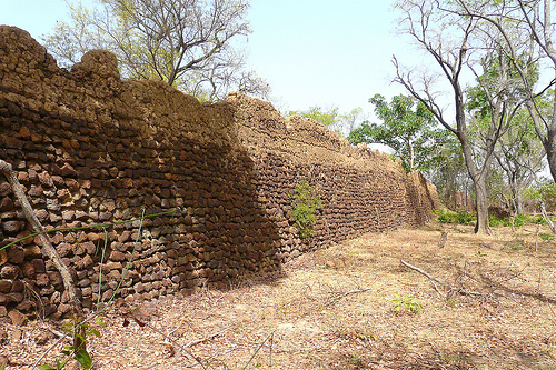
The Ruins of Loropéni are characterized by imposing quadrangular perimeter walls constructed from laterite stone, a reddish, iron-rich material abundant in the region. These walls enclose an area of about 1.113 hectares (2.75 acres), standing up to 6 meters (20 feet) high and 1.2 meters (4 feet) thick in places, with some sections remaining 80% intact despite centuries of exposure. The structure forms a large fortress-like enclosure, divided into internal compartments that likely included residential areas, storage facilities, and possibly defensive features. Architectural elements suggest skilled masonry, with walls built without mortar, relying on precise stone fitting. Inside, remnants of an abandoned settlement are visible, though much is overgrown with dense shrubbery, trees, and vegetation, which partially obscures the site. The design reflects influences from regional fortified traditions, potentially used to protect gold stockpiles or inhabitants from raids. Compared to other Lobi-area fortresses, Loropéni is the most intact, showcasing a sophisticated layout that hints at organized urban planning in medieval West Africa.
Loropéni lies in the semi-arid savanna of southern Burkina Faso, at coordinates approximately 10°18′37″N 3°33′46″W, within the Loropéni Department of Poni Province. The site is positioned near the borders with Côte d’Ivoire to the south, Ghana to the southeast, and Togo further east, placing it in a strategic historical crossroads for trade. The surrounding landscape features flat to gently rolling terrain with laterite soils, scattered acacia trees, and seasonal grasslands that turn lush during the rainy season. The Black Volta River flows nearby, providing water resources that likely supported ancient inhabitants. A 670-acre buffer zone encircles the ruins to mitigate human encroachment, though the area is prone to environmental extremes, including tropical rains, strong winds, and bush fires. The nearest significant town is Gaoua, about 45 km to the east, while the capital Ouagadougou is roughly 400 km north.
As the best-preserved of around a dozen large quadrangular enclosures in southwestern Burkina Faso—and part of over 100 stone fortifications in the Lobi region—the ruins hold immense archaeological value for understanding pre-colonial African societies. They illuminate the trans-Saharan gold trade's impact on local economies, with evidence suggesting the site functioned as a hub for gold processing and storage. Limited excavations have revealed occupation layers dating to the 11th century, but vast unexcavated areas promise further discoveries about daily life, social organization, and cultural practices of the Lohron, Koulango, and possibly Kaan peoples. The site's inscription on UNESCO's list underscores its role in filling gaps in West African history, particularly regarding fortified settlements before European influence. Ongoing research could clarify ambiguities, such as the exact builders and purposes beyond trade protection.
Conservation of the Ruins of Loropéni is managed by the Committee of Protection and Management, in collaboration with UNESCO and local authorities, focusing on sustainable development and community involvement. Key challenges include erosion from heavy tropical rains and winds, rising damp, bush fires during dry seasons, burrowing animals undermining foundations, and extreme temperature fluctuations exacerbating stone degradation. A buffer zone helps prevent agricultural and quarrying encroachment, while restoration involves skilled local craftspeople who view the site as spiritually significant. The site was highlighted on the 2008 World Monuments Watch list, prompting enhanced management policies, including monitoring and minimal intervention to preserve authenticity. Efforts also aim to stimulate economic benefits for surrounding communities through tourism, though security issues in Burkina Faso pose ongoing risks. Future plans emphasize further excavations and climate-resilient strategies to safeguard the ruins for generations.
Tourism at Loropéni centers on cultural and historical exploration, with the ruins serving as Burkina Faso's premier heritage attraction despite low visitor numbers due to remoteness and national security concerns. Activities include guided tours of the site, where knowledgeable local guides explain the architecture, history, and trade significance; self-exploration along paths amid the overgrown walls; and photography of the dramatic stone structures. Nearby, visitors can engage in community interactions, such as visiting traditional Lobi villages for insights into indigenous crafts, folklore, and spiritual practices tied to the ruins. Hiking in the surrounding savanna or along the Black Volta River offers scenic views, while cultural festivals in Gaoua may coincide with visits. Birdwatching and observing small wildlife like rodents and birds in the vegetation add a natural element. Due to the site's spiritual importance to locals, respectful behavior is essential, and hiring a guide is recommended for deeper context and safety.
Accommodations near Loropéni are basic and limited, reflecting the area's underdeveloped tourism infrastructure. In the town itself, options are scarce, so most visitors stay in Gaoua, 45 km away, where modest guesthouses, budget hotels, and eco-lodges offer simple rooms with fans, shared bathrooms, and local cuisine. Notable choices include family-run auberges providing cultural immersion, with rates starting around $20-50 USD per night. For more comfort, Ouagadougou has mid-range hotels, but it's a full day's drive. Camping near the ruins is possible with permission, though facilities are minimal; eco-camps in the buffer zone emphasize sustainability. Due to security, travelers often join organized tours that include lodging arrangements.
Access to Loropéni is challenging, requiring travel by road from Gaoua (45 km west) on unpaved tracks, best navigated with a 4x4 vehicle or motorcycle taxi; public buses or shared taxis from Ouagadougou (about 400 km, 6-8 hours) connect to Gaoua. No direct flights serve the area; the nearest airport is in Bobo-Dioulasso (200 km north), with onward road transfers. Entry to the ruins requires a small fee (around $5-10 USD) and often a guide. The best time to visit is during the dry season from November to February, when temperatures are milder (20-30°C/68-86°F), roads are passable, and bush fires are less risky; avoid the rainy season (June-October) due to flooding and mud, or the hot harmattan period (March-May) with dusty winds up to 45°C (113°F). Security advisories recommend checking travel warnings, as Burkina Faso faces terrorism threats; group travel is advised.
Loropéni stands out as Burkina Faso's sole UNESCO World Heritage Site, embodying a rare, well-preserved example of pre-European fortified architecture in West Africa, with walls enduring over a millennium. Its enigmatic history—tied to gold trade mysteries and unexcavated secrets—adds an aura of intrigue, while spiritual reverence among local communities infuses visits with cultural depth. Unlike more famous African ruins, it highlights sub-Saharan trade networks rather than colonial eras, offering a window into indigenous ingenuity and resilience amid environmental and historical shifts.