Location: Map
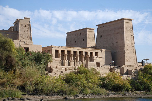
Agilkia Island (also spelled Agilika or Agilkia), now home to
the relocated Philae Temple complex (often called Philae Island
temples), is one of Egypt’s most picturesque and historically
significant archaeological sites in Aswan, Upper Egypt.
Originally situated on nearby Philae Island near the First
Cataract of the Nile, the complex was meticulously dismantled
and moved to Agilkia Island (about 500 meters away and reshaped
to mimic the original contours) between 1972–1980 as part of the
UNESCO Nubia Campaign to save it from flooding caused by the
Aswan High Dam. The island was leveled and landscaped to
replicate the original setting, preserving its sacred Nile
island character.
Philae (ancient Egyptian name meaning
something like “boundary” or referring to its frontier location)
served as a major cult center dedicated primarily to the goddess
Isis, with strong associations to the Osiris myth. Construction
spanned centuries, from possible early shrines in the Pharaonic
era (e.g., contributions by Taharqa of the 25th Dynasty, Psamtik
II, Amasis II, and Nectanebo I of the 30th Dynasty) through
extensive Ptolemaic building (especially under Ptolemy II
Philadelphus, who began the main Temple of Isis), and into the
Roman period (additions by emperors like Augustus, Trajan,
Hadrian, and Diocletian).
It was one of the last strongholds
of ancient Egyptian religion, remaining active into the 5th–6th
centuries AD, long after Christianity’s rise. The site preserves
the last known hieroglyphic inscription (AD 394 by a priest
named Esmet-Akhom) and the last Demotic inscription (AD 452). It
later saw Christian conversions (e.g., the Temple of Isis turned
into a church dedicated to Saint Stephen), with some deliberate
defacement of pagan imagery.
Philae attracted pilgrims from
Egypt, Nubia, and the broader Mediterranean, serving as a center
for the Isis cult (which spread widely in Greco-Roman times),
Osiris mysteries, and healing/protection rites. Nearby Bigeh
Island was traditionally linked to Osiris’s tomb.
The
relocation was an engineering marvel: the complex was
documented, a cofferdam built around the original island, water
pumped out, structures dismantled into ~40,000 numbered blocks
(2–25 tons each), transported, and reassembled on higher ground
on Agilkia with reinforced foundations. Italian firms led much
of the work under UNESCO.
The complex is compact but richly detailed, best explored on foot
after a scenic boat ride from the mainland marina near the Old Aswan
Dam. Major elements include:
Temple of Isis (Main Temple): The
largest and central structure, begun by Ptolemy II and expanded later.
It features two monumental pylons (gateway towers), a colonnaded court,
hypostyle hall, inner sanctuaries, and a mammisi (birth house). Reliefs
depict Isis, Osiris, and Horus myths—including Isis suckling Horus,
divine birth scenes, offerings, and royal legitimacy. The inner chambers
are rich in symbolic imagery of resurrection and protection. One of the
last active pagan temples, it was later converted to a church.
Kiosk
of Nectanebo I: One of the oldest surviving parts (30th Dynasty),
originally a vestibule or entrance structure with graceful columns;
incorporated into the later complex.
Temple of Hathor: A smaller,
charming temple built by Ptolemy VI Philometor and Augustus, dedicated
to Hathor (goddess of music, love, and joy). Columns feature
Hathor-headed capitals (often with musical or palm motifs). It includes
vibrant, well-preserved reliefs and was a delight for 19th-century
travelers.
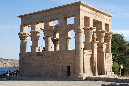
Kiosk of Trajan (or Trajan’s Kiosk): A standout open-air
pavilion (also called Pharaoh’s Bed) from the Roman period (Trajan,
98–117 AD), with 14 graceful columns (some with Corinthian-style
capitals) and no roof (lost long ago). It features fine reliefs of
Trajan offering to Isis, Osiris, and Horus. Its elegant, photogenic form
fronts the complex and symbolizes Roman-Egyptian syncretism.
Gateway
of Hadrian: A monumental Roman-era entrance with detailed hieroglyphic
carvings showing mythological scenes, Isis rituals, pharaonic offerings,
and protective symbols. It highlights Roman contributions and imperial
piety toward Egyptian gods.
Other Features: Colonnades (including a
double colonnade approach), smaller chapels, obelisks (one famously
taken to England by William John Bankes, aiding hieroglyph decipherment
alongside the Rosetta Stone), granite lions, and later Christian
elements. The dromos (processional way) and various courts connect the
structures. Reliefs throughout show vivid scenes of mythology,
offerings, and daily/ritual life, though some were damaged by early
Christians or iconoclasts.
The island’s layout preserves the
original sacred geography, with steep sides, Nile views, and a sense of
seclusion.
Ancient History and Religious Significance
Philae Island (the
original site) was a sacred granite island in the First Cataract of the
Nile, measuring roughly 380m by 120m before flooding. Its name and
location marked the southern frontier of ancient Egypt with Nubia. It
served as both a religious center and a commercial/trade hub between
Egypt and Nubia, with rapids making it a key transshipment point. The
island was associated with the Osiris myth: according to legend, Isis
found the heart of Osiris there after his death by Seth, making it a
major pilgrimage site for the cult of Isis.
Pharaonic Period:
Structures date back to at least the 25th Dynasty (e.g., possible
contributions by Taharqa) and 26th Dynasty (Psamtik II and Amasis II).
The earliest confirmed Isis-related building was a small kiosk by
Psamtik II. Significant additions came under Nectanebo I (30th Dynasty,
ca. 380–362 BCE), including a kiosk and gateway. The island hosted
temples, shrines, and fortifications, with a strong garrison due to its
strategic border position.
Ptolemaic Era (ca. 332–30 BCE): This was
the peak building period, with over two-thirds of surviving structures
erected. Ptolemy II Philadelphus, Ptolemy V, and Ptolemy VI were major
contributors. The Temple of Isis became the dominant structure, expanded
with pylons, colonnades, a mammisi (birth house), and reliefs depicting
myths of Isis, Osiris, and Horus. Nubian kings like Arqamani and
Adikhalamani also added elements, possibly during periods of
collaboration or conflict. Philae attracted pilgrims from Egypt, Nubia,
and farther afield (including Greeks). It featured obelisks, colossal
statues, and vibrant painted reliefs.
Roman and Later Periods: Roman
emperors (Augustus, Tiberius, Hadrian) added or completed elements,
including Trajan’s Kiosk. The cult of Isis remained strong, blending
Egyptian, Greek, and Roman influences. Philae was one of the last
strongholds of ancient Egyptian religion, resisting Christianity longer
than most sites. It was not fully closed until the reign of Byzantine
Emperor Justinian I (ca. 535–537 CE), when the temple was converted into
a church. Coptic churches were also built nearby. Inscriptions
(including proskynemata and early Latin texts) attest to its enduring
importance.
The temples exemplified the persistence of Egyptian
artistic styles long after the pharaonic era, with detailed reliefs,
hypostyle halls, and sanctuaries. The island’s position near the Tropic
of Cancer created striking light and shadow effects on the architecture.
19th–20th Century Threats: Dams and Flooding
In the 19th century,
European explorers and Egyptologists documented Philae extensively
(e.g., the Philae obelisk helped decipher hieroglyphs alongside the
Rosetta Stone). The island’s temples were remarkably well-preserved
until modern interventions.
Aswan Low Dam (completed 1902,
heightened 1912 and 1933): Built by the British, this caused seasonal
flooding. Philae was submerged for much of the year (often up to a third
of the structures), leading to erosion, silt buildup, salt damage to
pigments, and vegetation loss. Visitors could only access it during
low-water periods (roughly August–December).
Aswan High Dam
(1960–1970): This created Lake Nasser and threatened permanent
submersion. While the international Nubia Campaign (led by UNESCO from
1960) saved many monuments (notably Abu Simbel), Philae’s initial
exclusion highlighted its vulnerability. Public outcry and its cultural
importance (“Pearl of the Nile”) prompted further action.
The
Great Relocation to Agilkia Island (1970s)
A massive international
engineering feat saved the site:
A cofferdam was built around Philae
to allow dewatering and access.
The complex (about 95 structures) was
meticulously documented, cleaned, and dismantled into roughly 40,000
numbered blocks (each 2–25 tons).
Italian companies (Condotte-Mazzi
consortium) led the work under UNESCO and Egyptian oversight, with an
Egyptian firm handling foundations.
Agilkia Island (nearby, slightly
downstream) was chosen for its similar landscape and higher elevation.
Its top was leveled and reshaped to mimic Philae’s contours as closely
as possible (about 12.4 meters higher overall).
Blocks were
transported by boat and reassembled like a giant puzzle between 1977 and
1980. The site was formally reopened in 1980.
This project was a
landmark in heritage preservation, demonstrating global cooperation. The
original Philae Island is now mostly submerged, with only its highest
points visible.
Modern Agilkia and the Philae Complex Today
Agilkia now hosts the reassembled temples, which retain much of their
original beauty and layout. Key features include the Temple of Isis
(main sanctuary), Trajan’s Kiosk, the Mammisi, pylons, colonnades, and
smaller shrines to Hathor, Imhotep, etc. It remains a major tourist
site, accessible by boat, with sound-and-light shows. Hieroglyphic texts
continue to be studied (e.g., by the Philae Temple Text Project).
Brief History and Significance
The original Philae Island temples
date back to at least the 4th century BCE (with earlier roots),
flourishing especially in the Ptolemaic period (e.g., under Ptolemy II,
IV, VI) and into Roman times. It served as a major pilgrimage center for
Isis worship, attracting devotees from Egypt, Nubia, and beyond. Isis
represented magic, motherhood, healing, and protection; the site
included shrines to related deities like Hathor, Horus, Osiris, and
others.
The temples operated as one of the last active pagan
sanctuaries into the 6th century CE, even after Christianity spread.
Parts were later adapted into churches, with crosses carved over
hieroglyphs and some defacement of “pagan” images (Horus figures often
survived better).
In the 20th century, the Aswan Low Dam (1902,
raised later) caused periodic flooding. The Aswan High Dam (1960s–1970s)
threatened permanent submersion. UNESCO led a massive international
rescue: the complex was dismantled into ~40,000 numbered blocks, the
nearby Agilkia Island was reshaped to mimic the original contours, and
everything was rebuilt higher up (about 500m away, raised ~12–13m)
between roughly 1972–1980. This engineering feat preserved the site
beautifully.
Today, it’s part of the Nubian Monuments UNESCO World
Heritage Site (with Abu Simbel and others).
How to Get There
Access is only by boat—part of the charm. Boats depart from the Marina
Philae / Shellal Dock area, about 8–12 km south of central Aswan (near
the Old Aswan Dam). Taxi from central Aswan takes ~15–20 minutes (EGP
70–100 one way; use Careem if available or negotiate).
Independent
visit: Buy temple entry ticket at the shore booth first (cash or card).
Then negotiate a motorboat round-trip (typically EGP 200–400 per boat,
not per person; aim for 60–90+ minutes wait time on the island). Boats
are private—haggle firmly but calmly; drivers start high. Confirm
round-trip and wait time clearly. Small notes helpful for tips/change.
Guided tours: Highly recommended for hassle-free logistics, especially
combined with Aswan High Dam and Unfinished Obelisk. Many hotels arrange
them; options via GetYourGuide, Viator, or local operators. Nile cruises
often include it as a stop.
Nile cruises/feluccas: Scenic approach;
some offer combined experiences.
The short boat ride (a few minutes)
offers great views and sets a reflective mood.
Opening Hours,
Tickets, and Practical Info (as of recent 2025–2026 data)
Hours:
Generally 7:00/8:00 AM – 4:00/5:00 PM daily (last entry ~15:00–16:00).
Confirm locally as they can vary with season/Ramadan.
Entry fee:
Around EGP 550 for foreign adults; ~EGP 275 for students (ID required).
Sound & Light Show has a separate fee.
Duration: 1.5–3 hours ideal
(including boat). Allow more for photography or relaxed pacing.
Sound
& Light Show: Evening option with dramatic lighting, narration of
Isis/Osiris myths—magical if your schedule fits.
What to See on
Agilkia Island
Start from the landing dock (south side). Explore
roughly clockwise. Key highlights:
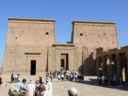
First Pylon: Imposing gateway with
reliefs of kings (e.g., Ptolemy XII) smiting enemies before Isis and
Horus. Note layered carvings, Greek inscriptions, and Christian-era
modifications.
Temple of Isis (main sanctuary): Heart of the
complex—hypostyle hall with floral columns, detailed reliefs of
myths/rituals, and inner sanctuary (once housing Isis’s sacred barque).
One of the best-preserved examples of late Egyptian temple design.
Mammisi (Birth House): Dedicated to the divine birth of Horus; reliefs
show Isis nursing the infant god. Symbolized pharaonic legitimacy.
Temple of Hathor: Smaller shrine with joyful motifs—musicians, dance,
and Hathor (goddess of music/joy) capitals.
Kiosk of Trajan
(“Pharaoh’s Bed”): Iconic open pavilion with elegant columns by the
water’s edge. Roman-era, unfinished but stunning, especially at golden
hour. Trajan depicted offering to Egyptian gods.
Other features: Gate
of Hadrian, colonnades, smaller shrines (e.g., Arensnuphis, Imhotep),
and remnants of Christian adaptations. Panoramic Nile views from various
points; the island landscaping echoes the original Philae.
Signage is
limited, so a guide brings the carvings and stories to life (mythology,
history, symbolism).
Best Time to Visit and Photography Tips
Season: October–April for mild weather (ideal for walking/exploring).
Avoid peak summer midday heat (>40°C/104°F).
Time of day: Early
morning (7–9 AM) for cooler temps, softer light, and fewer crowds. Late
afternoon for golden-hour magic and serenity. Midday sees more tour
groups.
Photography: Wide-angle for overall structures and pylons;
zoom for relief details. Reflections on the Nile are beautiful.
Sunrise/sunset or Sound & Light for drama. Early arrival helps avoid
crowds in shots.
In-Depth Visiting Tips
Hire a guide (local
Egyptologist preferred) for context—reliefs tell rich stories of gods,
kings, and rituals that are easy to miss otherwise. Tours balance this
well.
What to bring/wear: Comfortable walking shoes (uneven stone
paths), hat, sunscreen, water, and light layers. Modest clothing
respectful of the site (shoulders/knees covered). Camera/charger. Cash
for boat/tips/snacks.
Health/safety: Generally very safe for
tourists. Stay hydrated; watch for slippery areas near water. Standard
Egypt travel precautions (no photos of military sites, respect local
customs).
Crowds: Smaller than major sites but can feel busy with
groups. Go early or late to mitigate.
Combine with nearby
attractions: High Dam, Unfinished Obelisk, Nubian villages, or
Elephantine Island for a full Aswan day. Felucca sails enhance the Nile
experience.
Accessibility: Some stairs/uneven terrain; not fully
wheelchair-friendly, but the main areas are manageable with assistance.
Etiquette: No touching carvings; follow posted rules. Support local
boatmen/guides responsibly.
For your website (ermakvagus.com):
Emphasize the UNESCO rescue story, Isis mythology, cultural layering
(Egyptian-Greek-Roman-Christian), and the romantic boat approach.
Include practicals for independent travelers vs. tours. Paraphrase with
your engaging style—add personal traveler anecdotes or comparisons to
other Nile sites.
Location and Setting
Agilkia Island lies in the reservoir created
by the Old Aswan Dam (also known as the Aswan Low Dam), along the Nile
River in Aswan Governorate, Upper Egypt (Nubia region). Its coordinates
are approximately 24°01′31″N 32°53′03″E. It is positioned between the
Old Aswan Dam to the north/northwest and the Aswan High Dam (and Lake
Nasser) further upstream to the south. The island is near other features
like Bigge (or Bigeh) Island and is about 500 meters (roughly 1,600
feet) from the original Philae Island site.
The surrounding landscape
is dramatic and characteristic of the First Cataract region of the Nile:
rocky granite outcrops, desert hills, and the controlled waters of the
Nile. The area marks a historical boundary between ancient Egypt and
Nubia, with rapids (now largely tamed by dams) that historically
influenced trade and navigation. The island sits in a reservoir
environment where water levels are managed, creating a scenic,
island-dotted stretch of the Nile popular for boat tours.
Size,
Topography, and Geology
Size: Agilkia is a relatively small island,
similar in scale to the original Philae Island, which measured roughly
380–500 meters (about 1,250–1,640 feet) long north-to-south and around
120–160 meters (390–525 feet) wide east-to-west. Exact modern dimensions
are comparable, though modified by engineering.
Topography: The
island features a rocky, somewhat elevated granite base with engineered
landscaping. To accommodate the relocated temples, engineers leveled the
top of Agilkia to replicate the contours and elevation of the original
Philae Island as closely as possible (raising the site about 12–20
meters higher than the old location to stay above flood levels). This
involved removing the upper portion of the island and creating
foundations, pathways, and courtyards that mimic the ancient layout. The
terrain includes relatively flat areas for the temple complex,
surrounded by steeper rocky shores and some vegetated spots (trees,
shrubs, and gardens added post-relocation).
Geology: Composed
primarily of syenite/granite bedrock, typical of the Aswan region’s
ancient crystalline rocks. The Nile here cuts through the Precambrian
basement complex, with granite formations that have resisted erosion and
provided stable building material for millennia. The island’s shores are
rocky, with some alluvial deposits or engineered fill.
Historical
Context and Engineering Modifications
Originally, the Philae Temple
complex stood on nearby Philae Island (submerged or heavily flooded
after the Old Aswan Dam’s construction in 1902, with worsening
conditions after height increases). The Aswan High Dam (completed 1970)
threatened permanent inundation, prompting a major UNESCO international
rescue campaign in the 1960s–1970s.
The temples were meticulously
dismantled into tens of thousands of blocks (around 40,000), documented,
and moved.
Agilkia was selected and reshaped: its summit was removed,
the island was landscaped to match Philae’s topography, and reinforced
foundations were built.
Reconstruction occurred mainly between 1977
and 1980. The result preserves the temples’ orientation and setting
relative to the Nile.
This engineering feat not only saved the
monuments but adapted the island’s geography to sustain them long-term
in the controlled reservoir environment.
Hydrology and
Environment
Agilkia sits in a regulated section of the Nile, where
water levels are stabilized by the dams (unlike the original seasonal
flooding that once submerged parts of Philae for months each year). The
surrounding reservoir supports boat access (short trips from the
mainland or nearby docks) and creates a serene, reflective setting for
the temples, especially at sunrise/sunset.
Vegetation is limited but
includes introduced plants, palms, and greenery around the temples,
contrasting with the arid desert backdrop. The region’s hot, dry climate
(low rainfall, high evaporation) has helped preserve the stone
structures. Wildlife includes Nile birds, fish in the reservoir, and
occasional visitors to the shores.