Location: Map
Open: 6am- 4pm winter
6am- 5pm summer
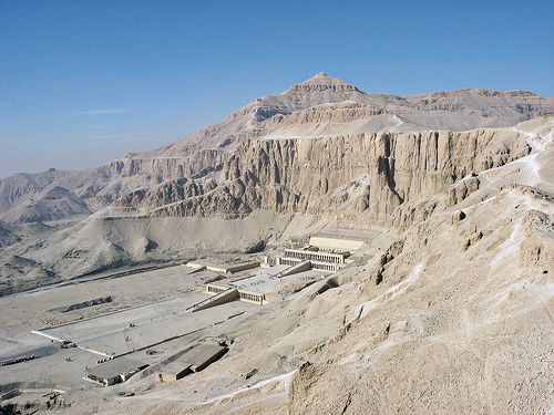
Deir el-Bahri, also known as Dayr al-Bahri or Djeser-Djeseru in ancient Egyptian (meaning "Holy of Holies"), is a renowned archaeological complex of mortuary temples and tombs situated on the west bank of the Nile River, opposite the modern city of Luxor in Egypt. This site forms a key part of the Theban Necropolis, a vast burial ground associated with ancient Thebes, and is celebrated for its architectural innovation, historical significance, and stunning integration with the natural landscape. The complex primarily features three major temples: the earliest built by Mentuhotep II during the Middle Kingdom, the iconic terraced temple of Queen Hatshepsut from the New Kingdom, and a smaller one by Thutmose III. Spanning over 3,500 years of use, Deir el-Bahri served as a sacred site for funerary cults, royal burials, and religious rituals dedicated to gods like Amun-Ra, Hathor, and Anubis. Its name derives from Arabic, meaning "northern monastery," referencing a Coptic Christian monastery established there in the 7th century CE. Inscribed as part of the UNESCO World Heritage Site "Ancient Thebes with its Necropolis" in 1979, Deir el-Bahri attracts visitors for its blend of pharaonic grandeur and dramatic cliffside setting, though it has faced modern challenges including a tragic 1997 terrorist attack that killed over 60 people, mostly tourists. As of 2025, ongoing excavations and restorations continue to reveal insights into ancient Egyptian society, with recent discoveries like a 3,500-year-old stone chest highlighting its enduring archaeological value.
Deir el-Bahri is located in the Luxor Governorate of Upper Egypt, at coordinates approximately 25°44′15″N 32°36′27″E, nestled in a natural bay formed by towering limestone cliffs on the west bank of the Nile, directly east of the Valley of the Kings. This cliffside basin, part of the Theban Hills, creates a dramatic amphitheater-like setting that enhances the site's isolation and sacred aura, with the cliffs rising sharply to form a natural backdrop. The geography integrates fertile Nile floodplain to the east with arid desert plateaus to the west, facilitating ancient agricultural support while providing raw materials like limestone for construction. The site's strategic position allowed for long causeways connecting the temples to valley temples along the Nile, which included docking facilities for river processions. This location not only symbolized the transition from life (east bank) to death (west bank) in Egyptian cosmology but also protected the structures from annual Nile floods. The surrounding landscape includes adjacent valleys like Deir el-Medina and is vulnerable to rockfalls due to the unstable cliffs, which have damaged structures over millennia.
Deir el-Bahri experiences a hot desert climate (Köppen BWh), typical of the Luxor region, with extreme temperatures, low humidity, and minimal rainfall. Annual precipitation averages less than 1 millimeter, occurring sporadically in brief winter showers. Summers (May–September) are intensely hot, with average highs exceeding 40°C and occasional peaks up to 50°C, accompanied by dry, dusty winds like the khamsin. Winters (December–February) are milder, with daytime temperatures around 20–25°C dropping to 5–10°C at night. The site's exposed location in a cliff basin amplifies heat retention during the day and rapid cooling at night, creating significant diurnal variations. As of 2025, climate change has led to more frequent heatwaves and dust storms, potentially accelerating erosion of the sandstone and limestone structures through thermal expansion and wind abrasion. Visitors are advised to explore during cooler months (October–April) to avoid heat-related risks.
Deir el-Bahri (Arabic: الدير البحري, al-Dayr al-Baḥrī, meaning “the
Northern Monastery”; ancient Egyptian name for the main temple complex
Djeser-djeseru, “Holy of Holies”) is one of ancient Egypt’s most
spectacular and historically layered archaeological sites. Located on
the west bank of the Nile in a dramatic natural bay in the Theban Hills
(part of the Theban Necropolis), directly opposite modern Luxor (ancient
Thebes), it served as a sacred landscape for over two millennia—from the
Middle Kingdom to the Ptolemaic, Roman, and Coptic periods. The site’s
cliffs were long revered as the domain of Hathor (“Lady of the West”),
the goddess of the necropolis, divine motherhood, and regeneration,
which made it an ideal location for royal mortuary temples and tombs.
The name “Deir el-Bahri” derives from a Coptic Christian monastery (the
Monastery of Apa Phoibammon) built into and around the ruins in the 7th
century CE, when the area was repurposed by monks.
Middle Kingdom
Origins: Mentuhotep II’s Innovative Temple (c. 2055–2004 BCE)
Deir
el-Bahri’s history as a major construction site begins with Nebhepetre
Mentuhotep II (11th Dynasty), the pharaoh who reunified Egypt after the
First Intermediate Period’s chaos. His mortuary temple-tomb complex,
called Akh-sut Nebhepetre (“Glorious Are the Places of Nebhepetre”), was
the first major structure here and pioneered the terraced,
cliff-integrated design that later pharaohs emulated.
Built on
multiple levels in the bay, it featured a long causeway (about 16 m
wide) leading from a now-lost valley temple to a forecourt, then ramps
to terraces. The centerpiece was a square, mastaba-like structure
(possibly symbolizing the primeval mound of creation) atop the upper
terrace, surrounded by colonnades and a hypostyle hall. An underground
passage (via the Bab el-Hosan gate) led to an unfinished tomb or
cenotaph containing a seated statue of the king. Reliefs depicted
military campaigns, hunts, boat processions, and daily life. Six shrines
housed royal women (including queens like Ashayet, Henhenet, and Kawit,
some serving as Hathor priestesses), each with finely carved sarcophagi.
The temple included gardens with sycamore figs and flowerbeds
(symbolizing regeneration), foundation deposits (pottery, tools, animal
bones), and strong Osirian and Hathoric symbolism tying the king’s cult
to resurrection and the necropolis. Private tombs of officials and
family members dotted the surrounding cliffs (e.g., TT319 for Neferu and
Iah). Only fragments survive today due to later dismantling and
rockfalls, but it remains a landmark of Middle Kingdom innovation.
New Kingdom Flourishing: Hatshepsut’s Masterpiece and Thutmose III’s
Additions (18th Dynasty, c. 1479–1425 BCE)
The site reached its
architectural zenith in the early 18th Dynasty. Queen-Pharaoh Hatshepsut
(r. c. 1479–1458 BCE) built her spectacular mortuary temple
Djeser-Djeseru (“Holy of Holies”) directly beside (and partially reusing
materials from) Mentuhotep’s complex. Designed primarily by her steward
and architect Senenmut (who had his own nearby tomb, TT353), it was
constructed over about 15 years (her regnal years 7–20) and is
considered one of ancient Egypt’s most harmonious buildings.
The
temple spans three massive limestone terraces (total length ~273 m,
height ~24.5 m) connected by central ramps, originally surrounded by
gardens and approached by a ~1 km causeway from a valley temple. Each
terrace has double colonnades (square piers, with some Proto-Doric
columns in the northwest Hathor chapel). Key elements include:
Lower terrace: Sphinx avenue, porticoes with reliefs of obelisk
transport from Aswan and foundation rituals.
Middle terrace: Famous
Punt expedition reliefs (Year 9: ships, exotic goods, myrrh trees,
African villagers) and the divine birth cycle (Hatshepsut as daughter of
Amun-Re and Queen Ahmose, legitimizing her rule as a female pharaoh).
Upper terrace: Coronation scenes, solar cult court, mortuary chapels for
Hatshepsut and her father Thutmose I, and the central sanctuary for
Amun-Re’s barque (used in the Beautiful Festival of the Valley
procession from Karnak).
Chapels to Hathor (cow goddess) and Anubis
(embalming rites).
Over 25 colossal Osiride statues of Hatshepsut
(some up to 7.8 m tall) on pillars.
The temple served as a
“Temple of Millions of Years” for sustaining Hatshepsut’s ka (spirit)
through daily offerings, while doubling as political propaganda
affirming her divine right and Theban power. It emulated Old Kingdom
pyramid complexes but innovated with its cliff integration and festival
focus.
Thutmose III (Hatshepsut’s nephew/stepson and co-ruler,
sole ruler after her death) built a smaller temple, Djeser-Akhet (“Holy
of the Horizon”), higher up between the two earlier structures around
1435–1425 BCE. It featured a basilica-style hypostyle hall with
clerestory windows (an early innovation) and was dedicated mainly to
Amun-Ra, with a Hathor shrine containing a protective cow statue.
Reliefs showed rituals and the Beautiful Festival of the Valley. About
two decades into his sole reign, Thutmose III ordered the systematic
erasure of Hatshepsut’s images, names, and statues (smashed and buried
in pits), likely to eliminate the precedent of female rule or resolve
succession issues (damage largely halted under his son Amenhotep II).
Further defacement occurred under Akhenaten (Amarna period), with later
restorations.
Amenhotep I also built a small temple here and buried
his wife nearby (TT358).
Later Periods: Burials, Reuse, and the
Coptic Monastery (Third Intermediate Period Onward)
By the Third
Intermediate Period (c. 1070–664 BCE), the temples fell into disuse as
active royal cults but became a necropolis for high priests of Amun and
their families. The cliffs hid two famous caches:
DB320/TT320
(Royal Cache): Discovered unofficially ~1871 by the Abd el-Rassul family
and cleared in 1881. It contained ~50 royal mummies (including Ahmose I,
Amenhotep I, Thutmose I–III, Seti I, Ramesses II and III) reburied by
21st Dynasty priests (e.g., under Pinedjem II) to protect them from tomb
robbers.
Bab el-Gasus (1891): 153 mummies of Amun priests.
In
the Ptolemaic period (332–30 BCE), Hatshepsut’s sanctuary was
refurbished and rededicated to the deified Imhotep and Amenhotep son of
Hapu (with Greek visitor inscriptions). Thutmose III’s temple saw
continued Hathor votive offerings.
By the 6th–8th centuries CE,
Coptic monks converted parts of Hatshepsut’s temple into the Monastery
of St. Phoibammon (or Apa Phoibammon), painting over reliefs with
Christian motifs and leaving graffiti (latest ~1223 CE). This monastic
use gave the site its modern Arabic name.
Archaeological
Exploration, Discoveries, and Modern History
Serious excavation began
in the 19th century:
Auguste Mariette (1850s–60s) and others made
initial probes.
Édouard Naville (Egypt Exploration Fund, 1893–1906)
cleared Hatshepsut’s and Mentuhotep’s temples.
Herbert Winlock
(Metropolitan Museum of Art, 1911–1936) recovered thousands of smashed
Hatshepsut statues (many reconstructed), ritual objects, and models from
private tombs like Meketre’s (TT280).
Since 1961, the
Polish-Egyptian Mission (Polish Centre of Mediterranean Archaeology,
University of Warsaw) has led restorations of Hatshepsut’s temple
(stabilizing terraces, reconstructing Osiride statues, reliefs, and
chapels; key areas opened progressively, with full public access
enhanced since 2023). They rediscovered and studied Thutmose III’s
temple (1961–62). Ongoing work includes 3D scanning, conservation
against rockfalls/earthquakes, and new finds like foundation deposits,
votive offerings to Hathor, and recent tombs (e.g., 2023–2025
discoveries of decorated blocks, ceremonial tools, and intact burials).
The site has suffered from natural rockfalls, earthquakes, stone
robbing, and deliberate erasures but remains remarkably preserved thanks
to restorations. Tragically, in 1997, Islamist terrorists attacked
tourists at Hatshepsut’s temple, killing 62 people (including many
foreigners), highlighting security challenges in the area.
Today, as
part of the UNESCO World Heritage-listed Theban Necropolis, Deir
el-Bahri is a major tourist destination. Its temples exemplify ancient
Egyptian architectural genius, royal propaganda, religious continuity,
and the enduring sacred power of the Theban landscape. Mentuhotep’s
pioneering design influenced Hatshepsut, whose temple in turn shaped
later mortuary architecture—making Deir el-Bahri a cornerstone of
Egypt’s cultural legacy.
Deir el-Bahri (also spelled Deir el-Bahari or Dayr al-Bahri), meaning
“northern monastery” in Arabic due to a later Coptic monastery built
there in the 7th century CE, is a spectacular archaeological site in a
natural semicircular bay of towering limestone cliffs on the west bank
of the Nile, opposite ancient Thebes (modern Luxor). The site’s dramatic
topography—a sheer rock amphitheater rising dramatically from the desert
floor—shaped its architecture, creating one of ancient Egypt’s most
harmonious integrations of built form and natural landscape. Three major
royal mortuary temples stand here, spanning the Middle and New Kingdoms,
all connected by long causeways (approximately 1 km each) to valley
temples with Nile docking facilities for festival processions. The
temples exemplify a shift in Egyptian sacred architecture: from the Old
Kingdom’s isolated pyramid complexes to terraced, processional “temples
of millions of years” that emphasized public ritual, divine kingship,
and direct axial access for the barque (sacred boat) of Amun-Re during
the annual Beautiful Festival of the Valley.
1. Mentuhotep II’s
Mortuary Temple (c. 2055–2004 BCE, 11th Dynasty)
The oldest structure
at the site, built by Mentuhotep II (Nebhepetre), the pharaoh who
reunified Egypt after the First Intermediate Period. Called Akh-sut
Nebhepetre (“Transfigured are the places of Nebhepetre”), it pioneered
the terraced cliffside design that later influenced Hatshepsut. Much of
its superstructure has been lost to rockfalls and erosion, but
excavations and reconstructions reveal an innovative hybrid of Memphite
(northern pyramid) and Theban (southern rock-cut) traditions.
Key
architectural features:
Overall layout: A long causeway led from the
valley temple to a vast forecourt. The main temple rose on a high
artificial platform accessed by a wide central axial ramp.
Terraced
platform and colonnades: The platform supported multiple pillared halls,
including an ambulatory (covered walkway) with 140 octagonal columns
surrounding a central square massif (debated reconstructions include a
low pyramid, mastaba-like structure, or symbolic primeval mound/solar
altar possibly flanked by obelisks).
Inner elements: Beyond the outer
colonnades lay a hypostyle hall (roof supported by columns) and the
royal tomb integrated behind or beneath the structure. The design
included separate shrines (e.g., an earlier Hathor sanctuary) and
emphasized both the king’s mortuary cult and Amun worship.
Materials
and innovations: Primarily limestone with painted reliefs. It was the
first known mortuary temple to host divine processions and elevate the
king as an active participant in Amun-Re rituals, breaking from Old
Kingdom seclusion. The axial ramp and terraced elevation created a
monumental ascent symbolizing the pharaoh’s journey to the afterlife.
The temple’s ruins lie south of Hatshepsut’s, partially overlapped
or adjacent in the cliff bay.
2. Hatshepsut’s Mortuary Temple
(Djeser-Djeseru, “Holy of Holies,” c. 1479–1458 BCE, 18th Dynasty)
The site’s crowning achievement and best-preserved monument, built by
Queen-Pharaoh Hatshepsut and designed by her steward and architect
Senenmut (or possibly High Priest Hapuseneb, with Hatshepsut’s direct
input). Spanning roughly 273.5 m long × 105 m wide × 24.5 m high
(terraces rising an additional ~5–6 m each, totaling ~30 m), it
dramatically expands Mentuhotep II’s model while introducing radical
innovations. The temple is partially rock-hewn into the cliffs, with its
back chambers cut directly into the limestone massif capped by El-Qurn
peak (where Hatshepsut’s tomb KV20 lies). Its perfect east-west axial
alignment allowed the barque of Amun-Re to process directly from Karnak
across the Nile, while the north-south axis symbolized the pharaoh’s
life cycle (coronation to rebirth).
Materials: Primarily fine
local limestone blocks (some reused from Mentuhotep’s temple), with red
granite for door lintels, false doors, and select elements, and
occasional sandstone. Walls were carved with exquisite painted raised
reliefs depicting historical events, rituals, and propaganda.
Innovations over Mentuhotep II:
Elimination of the central massif to
create wide, open terraces for unobstructed axial processional access.
Overwhelming use of colossal Osiride statues (mummiform figures of
Hatshepsut as Osiris) for public display of royal power—unlike the more
restrained statues of earlier periods.
Integration of multiple deity
shrines (five cult sites total) directly into the main structure rather
than separate buildings.
Dramatic landscape harmony: terraces mimic
the natural strata of the cliffs, with colonnades echoing the horizontal
rock layers.
Detailed layout by terrace (accessed via central
ramps that bifurcate the porticoes):
Lower Terrace (120 m deep × 75 m
wide): Enclosed by walls with a single east entrance gate. Flanked by
two deep porticoes (25 m wide, two rows of 22 square columns each)
featuring reliefs of obelisk transport from Aswan and foundation
rituals. Originally planted with exotic trees (e.g., myrrh from Punt)
and T-shaped basins. Central ramp flanked by recumbent lion statues.
Outer ends once held 7.8 m tall Osiride statues.
Middle Terrace (75 m
deep × 90 m wide): Western porticoes (two rows of 22 columns) with
world-famous reliefs—the southern side depicts Hatshepsut’s expedition
to Punt (modern Somalia/Eritrea) with ships, incense trees, and exotic
goods; the northern side shows her divine birth (Amun-Re fathering her
with Queen Ahmose) to legitimize her rule. South corner: Hathor shrine
(portico with distinctive Hathor-headed capitals, two successive
hypostyle halls with 12 + 16 columns, vestibule, and double sanctuary).
North corner: Smaller Anubis shrine (hypostyle hall with 12 columns in
three rows of four, leading to inner rooms and niche).
Upper Terrace:
Reached by central ramp; fronted by a colonnade of 26 columns bearing
5.2 m Osiride statues of Hatshepsut (southern ones wearing the White
Crown of Upper Egypt, northern the Double Crown of Upper and Lower
Egypt). Opens to a large open courtyard surrounded by pillars (deeper on
west side) with statue niches. Central west: Amun-Re sanctuary (partly
rock-cut barque chapel with skylight for illumination, inner chambers
with offering scenes, granite lintel, and cult statue niche). North off
courtyard: Solar cult court with open-sky altar and Ra-Horakhty reliefs.
South: Royal mortuary cult complex (two chapels for Hatshepsut and her
father Thutmose I, including the largest vaulted hall chapel in ancient
Egyptian architecture—roughly 13.3 m × 5.3 m with ~6.3 m height).
The temple was extensively damaged after Hatshepsut’s death
(Thutmose III erased her images; Akhenaten later attacked Amun
references; rockfalls caused further destruction), but has undergone
major restorations, especially by Polish missions since the 1960s.
3. Thutmose III’s Mortuary Temple (c. 1435 BCE, 18th Dynasty)
The
smallest and least preserved of the three, built by Thutmose III
(Hatshepsut’s nephew/stepson) higher up in the cliff bay, positioned
above and between the earlier temples. Dedicated primarily to Amun, it
features a more compact layout with hypostyle hall elements (including
possible clerestory lighting) and standard New Kingdom mortuary
features. Its ruins were only fully identified during 20th-century
Polish restorations; little superstructure survives due to rockfalls and
deliberate dismantling in antiquity.
Overall Site Context and
Significance
All three temples shared causeways for processional use
and were later partially overlaid or damaged by the Coptic monastery.
The site’s architecture represents a pinnacle of creative site
exploitation: terraces ascend the natural slope, colonnades provide
rhythmic shadow and light, and axial planning facilitates divine-human
interaction. Hatshepsut’s temple, in particular, influenced later New
Kingdom funerary architecture and is often compared to Greek classical
harmony for its proportions and landscape fusion. Today, it is a UNESCO
World Heritage site (part of Ancient Thebes) and a major tourist
destination, with ongoing conservation revealing more about its
construction techniques and relief programs.
Archaeological work at Deir el-Bahri has yielded transformative finds. In 1881, the DB320 cache revealed royal mummies, including those of Ahmose I and Ramesses II, hidden by priests. Bab el-Gasus in 1891 uncovered 153 priest mummies. Hatshepsut's temple excavations by Naville exposed Punt reliefs and divine birth scenes, while Winlock found discarded statues from Thutmose III's iconoclasm. Polish missions since 1961 restored terraces and sanctuaries, uncovering marine species depictions and ritual artifacts. A 2020 discovery included a limestone chest with linen-wrapped offerings like a goose skeleton and ibis egg, possibly from Thutmose II's reign. Ongoing studies, as in the 2023 "Deir el-Bahari Studies Vol. 3," analyze reliefs and broader context, with bioarchaeological insights into ancient flora and fauna.
Conservation at Deir el-Bahri addresses natural and human-induced threats. Rockfalls from cliffs have damaged structures since antiquity, exacerbated by earthquakes and climate change-driven erosion. Tourism pressures, urban development, and agricultural encroachment pose risks, alongside potential flooding. Efforts include 19th-century clearances by Mariette and Naville, 20th-century reconstructions by Baraize, and Polish-led restorations since 1968, focusing on stability, legibility, and reversibility per international standards. UNESCO, through the Ministry of Antiquities, coordinates comprehensive management plans involving stakeholder engagement, visitor control, and community programs. As of 2025, boundary modifications and infrastructure projects aim to mitigate threats, with the site in excellent condition overall due to ancient techniques, though ongoing monitoring is essential.
Deir el-Bahri is accessible via day trips from Luxor, typically by taxi, bus, or guided tour across the Nile, with entry fees around 200–300 EGP including the Valley of the Queens nearby. Activities include exploring terraces, viewing reliefs, and photography; hot air balloon rides offer aerial views. Best visited in winter for comfort, with crowds peaking mornings—audio guides and Egyptologists enhance experiences. Facilities are basic, with restrooms and shades; security has improved post-1997. The site's significance lies in its architectural pioneering (terraced designs influencing later temples), material witness to Egyptian civilization (criteria i, iii, vi per UNESCO), and insights into gender, power (Hatshepsut's rule), trade (Punt expedition), and religion. It symbolizes Thebes' golden age, contributing to global understanding of ancient cultures while supporting Egypt's tourism economy.