Location: Faiyum Governorate Map
Karanis, also known as Kom Aushim, is an ancient Greco-Roman agricultural town located in the Fayoum Oasis region of Egypt. Founded in the 3rd century BCE during the Ptolemaic period, it served as a vital farming settlement with a diverse population of Egyptians, Greeks, and later Romans, reflecting the cultural fusion of the era. The site is renowned for its well-preserved ruins, including multi-story mudbrick houses, temples, and granaries, which provide insights into daily life in ancient Egypt under Hellenistic and Roman influence. Recent archaeological studies, including radiocarbon dating, indicate that Karanis endured longer than previously thought, surviving until the 7th century CE amid the Arab conquest.
Karanis is situated on the northeastern edge of the Fayoum Depression, approximately 80 kilometers southwest of Cairo and about 30 kilometers north of the modern city of Fayoum. Its coordinates are roughly 29°22′N 30°54′E, perched on a mound elevated about 12 meters above the surrounding fertile plain, which was irrigated by canals from the Nile. The site's arid desert landscape contrasts with the lush agricultural fields of the oasis, created by ancient hydraulic engineering that transformed the area into a productive granary for Egypt. This strategic position facilitated trade and farming, with crops like wheat, barley, and olives being central to its economy.
Pre-Ptolemaic Context
Although Karanis itself was
founded during the Ptolemaic period, the Fayum Oasis region where it is
located has a much deeper history of human activity. The area was
transformed into a fertile agricultural basin through ancient hydraulic
engineering, with evidence of settlements dating back to the Middle
Kingdom (circa 2050–1710 BCE) and earlier. However, no Pharaonic-era
remains have been found directly at the Karanis site, suggesting it was
undeveloped prior to Greek colonization. The Fayum's irrigation systems,
including canals fed by the Nile, were expanded under the Ptolemies,
building on earlier Egyptian efforts to reclaim land from the desert.
Ptolemaic Founding and Early Occupation (3rd Century BCE – 30 BCE)
Karanis was established in the third century BCE, around 250–270 BCE, by
Ptolemy II Philadelphus as part of a broader initiative to colonize and
cultivate the Arsinoite nome (modern Fayum Oasis). Named in Greek as
"Karanis" (possibly meaning "town" or derived from local terms), it was
one of several agricultural settlements designed to support Greek
veterans and immigrants through land grants, promoting Hellenistic
culture in Egypt. The town's layout featured a grid of streets, mudbrick
houses, and early temples, with a focus on farming crops like wheat,
barley, olives, and grapes, irrigated by restored canals.
The
population was diverse, blending native Egyptians with Greek settlers,
leading to a syncretic culture evident in religious practices honoring
both Egyptian gods (like Sobek, the crocodile deity) and Greek ones.
Early structures included the foundations of what would become the South
Temple, possibly built on an even earlier shrine, dedicated to crocodile
gods Pnepheros and Petesouchos. By the late Ptolemaic period (2nd–1st
century BCE), the town experienced stagnation due to neglected
irrigation infrastructure, political instability, and economic decline,
with limited growth and some areas falling into disrepair. The site's
size reached about 60 hectares, with an estimated peak population of
4,000, though it may have been up to three times larger at times.
Roman Period Expansion and Prosperity (30 BCE – 3rd Century CE)
Following Rome's conquest of Egypt in 30 BCE, Karanis underwent
significant revival under Emperor Augustus (r. 27 BCE–14 CE), who
recognized the Fayum's agricultural potential. He ordered the clearing
of silted canals and repair of dikes, boosting productivity and
attracting more settlers, including Roman veterans. This led to a period
of prosperity in the 1st–2nd centuries CE, with the town serving as a
key grain supplier for the empire. The population grew, and
infrastructure expanded, including multi-story mudbrick houses (some up
to three levels with courtyards, kitchens, and storage), granaries with
underground silos, bath complexes, and public spaces.
Key
constructions included the South Temple, expanded under Nero (54–68 CE)
with limestone pylons, courtyards, shrines, and associated buildings for
priests and banquets. The North Temple, built in the early Roman period,
was likely dedicated to a crocodile god like Soknopaios or a syncretic
form with Serapis/Zeus, featuring altars and Greco-Roman architectural
elements. Daily life revolved around farming, weaving, and trade, with
residents mostly poor, self-sufficient farmers as revealed by papyri
(primarily tax records in Greek, with rare Latin documents). Economic
recessions hit in the late 2nd century and mid-3rd century CE,
coinciding with imperial crises like plagues and invasions, leading to
some house collapses by the end of the 3rd century.
Artifacts from
this era, such as pottery, glassware (distinct "Karanis glass" style),
textiles, coins, and magical items (e.g., painted bones for rituals),
highlight a multicultural society with limited external contact.
Veterans were often culturally Greek from the Eastern Empire,
integrating into local Egyptian traditions.
Byzantine and Late
Antique Period (4th–7th Century CE)
In the 4th century CE, under
Byzantine rule, Karanis continued as a rural settlement despite earlier
signs of decline. Traditional views, based on papyri ending around the
370s CE and coins up to AD 460, suggested abandonment by the mid-5th
century due to environmental factors like silting canals and reduced
Nile floods. However, recent radiocarbon dating of archaeobotanical
samples (e.g., barley and lupin seeds from storage contexts) has revised
this timeline, showing consistent occupation through the 6th century and
into the mid-7th century CE (up to cal AD 648–669).
This period saw
remodeling of structures, reuse of older buildings, and asynchronous
neighborhood abandonment rather than total depopulation. Artifacts like
late Roman amphorae and African Red Slipware indicate ongoing
Mediterranean trade. The town endured political upheavals, including the
Sasanian conquest (618–629 CE), Byzantine reconquest, and the Arab
conquest (639–642 CE), amid climatic shifts like the Late Antique Little
Ice Age. Religious practices shifted toward Christianity, with possible
temple conversions, though crocodile cults persisted earlier. By the 7th
century, habitation dwindled, with full abandonment around AD 650 for
unclear reasons—possibly economic collapse, invasions, or environmental
degradation.
Abandonment and Post-Occupation
Karanis was
gradually abandoned after the 7th century CE, with structures buried
under sand, preserving organic materials due to the arid climate. The
site, known locally as Kom Aushim, was used in the 19th–early 20th
centuries by farmers for sebbakh (fertilizer from decayed organics),
leading to looting and damage.
Modern Excavations and Discoveries
Archaeological interest began in 1895 with Bernard Pyne Grenfell and
Arthur Surridge Hunt, who conducted initial digs but abandoned the site
due to plundering and lack of valuable finds. Major excavations occurred
from 1924 to 1935 under Francis W. Kelsey of the University of Michigan,
focusing on systematic recording of findspots, stratigraphy, and daily
life rather than treasures. Methods included a field numbering system
for objects, documentary films (digitized later), and recovery of over
3,000 papyri (mostly tax records from Diocletian to the 370s CE),
artifacts (pottery, glass, textiles, coins, toys, jewelry, mummified
crocodiles), and structures like houses and temples.
Subsequent work
includes Cairo University, the French Institute, Virginia Commonwealth
University, and the URU Fayum Project (UCLA, Groningen, Auckland). The
1974 Kom Aushim Museum displays artifacts. Recent studies, like GIS
reintegration of texts and objects, and radiocarbon dating, have refined
chronologies and highlighted themes like sonic landscapes and ritual
practices. These efforts reveal Karanis as a microcosm of Greco-Roman
Egypt, emphasizing ordinary lives amid cultural fusion.
Karanis (modern Kom Aushim or Kom Ushim), in Egypt’s
Fayum Oasis, was a medium-sized Greco-Roman agricultural town founded
around 270–250 BC by Ptolemy II Philadelphus as a garrison settlement on
newly reclaimed land near the shores of ancient Lake Qarun (Lake
Moeris). It thrived for nearly 900 years until abandonment around the
mid-5th to early 7th century AD, driven by canal silting, economic
decline, and the rise of Christianity. The site occupies a conspicuous
limestone ridge mound rising about 12 meters above the surrounding plain
(at +7 m above sea level), with a semi-organic yet planned urban layout
organized around two main north-south thoroughfares. Houses clustered in
blocks (insulae) around these streets, with meandering side lanes that
evolved over five occupation levels (A–E, from latest to earliest) as
streets and floors rose due to accumulated sand, debris, and wind-blown
deposits.
Excavations by the University of Michigan (1924–1935)
produced detailed topographic and architectural reports (summarized by
Elinor Husselman in 1979), revealing a functional, unpretentious town of
mudbrick construction with stone accents for prestige structures. The
architecture blends Egyptian temple traditions with Greco-Roman urban
planning, domestic features, and engineering—reflecting a multicultural
population (initially ~1,500, growing to ~3,500) of Egyptians, Greeks,
Macedonians, and later Romans. It served as a grain-collection and
taxation hub, with integrated economic facilities like granaries and
presses.
Temples: Egyptian-Style Stone Sanctuaries with
Greco-Roman Overlays
The town centered on two well-preserved
Ptolemaic/Roman limestone temples dedicated primarily to Sobek (the
crocodile god), in local forms such as Pnepheros, Petesuchos, and
Soknopaios, alongside syncretic deities (e.g., Serapis, Zeus-Ammon,
Isis, Harpocrates). Both were built (or rebuilt) in the 1st century AD
on earlier foundations and abandoned by the mid-3rd century AD. They
followed conventional Egyptian plans—symbolizing the cosmos from open
courts (primordial marsh) to enclosed sanctuaries (primeval mound)—but
incorporated Greco-Roman elements like inscriptions, colonnades, and
possible oracle features.
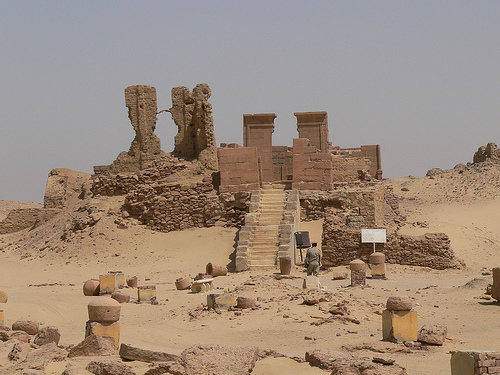
South Temple (larger, eastern edge of a
square; dedicated to Pnepheros and Petesuchos):
Constructed entirely
of limestone on bedrock in the latter 1st century AD (with a Greek
inscription on the main lintel originally naming Nero, later usurped by
Claudius; another Vespasian-era gate to the east). Layout: quay →
processional way → paved colonnaded courtyard → three-room interior. The
largest chamber led to a vestibule with deep wall niches for storing
mummified sacred crocodiles (used in ceremonies). The innermost
sanctuary held a large stone altar/platform with a low hidden chamber
(accessible via a small side hole), likely for priestly oracles. A
forecourt and pylon were later additions. The roof offers panoramic
views of the site and southern fields. Features included a sacred lake
and adjacent banquet hall/vat for lustral baths.
North Temple
(smaller, faces north; dedicated to Sobek variants plus
Serapis/Zeus/Ammon):
Gray limestone construction (end of 1st century
AD). Surrounded by a thick mudbrick temenos (enclosure) wall (partially
preserved to the north). Approach via two small entrance pylons; outer
corners decorated with four slender engaged columns. Similar interior:
paved courts → sanctuary with large stone altar and possible oracle
niche. A chapel at the north end opened off the inner court.
Both
temples included architectural provisions for crocodile cults (sacred
lakes, mummification niches, processions) and show Greco-Egyptian fusion
(e.g., colonnaded courts, imperial inscriptions).
Domestic
Architecture: Multi-Story Mudbrick Houses with Central Courtyards
Houses formed the bulk of the town—hundreds clustered in blocks sharing
party walls (occasionally courtyards) but otherwise independent and
self-sufficient. They ranged from simple three-room dwellings (e.g., for
Roman veterans) to elaborate villas for officials, reflecting social
stratification. Primary material: sun-dried mudbrick (laid in horizontal
interior courses; concave exterior beds to resist cracking), reinforced
with tree trunks (sycamore, palm, acacia). Stone was used sparingly for
lintels, foundations, stairs, and street-facing bases in wealthier
homes; wood (beams from large limbs) for roofs, doors, and windows.
Typical features (multi-storied, often 2–3 levels plus basement; evolved
over time with superimposed layers):
Central courtyard: Heart of
daily life—kitchen (ovens, fireplaces, Theban mills/mortars, grain
bins), small factory (olive presses, weaving), animal pen (troughs,
mangers), and workspace. Often open or partially covered.
Basements/underground rooms: Vaulted or domed storage (accessed by
continuous internal stairways of stone or mudbrick); connected to ground
level.
Upper floors and roof: Flat roofs (rafter-supported) used as
terraces; vaulted ceilings in affluent houses.
Windows and lighting:
Small, high-set slits (for light, ventilation, privacy); framed in wood,
sometimes barred or basket-shuttered. Oil lamps (glass or terracotta) in
molded wall niches (also for storage/shelves; blackened by smoke).
Interiors: Plastered walls with dark wash and white-painted lines
tracing brick courses; occasional religious frescoes or Classical-style
stucco around niches. Floors: mats/cushions. Furniture: wooden
stools/tables (lathe-turned legs), bed frames, reed/wood chests,
baskets. Doors: tooled joints, pivoting sockets, sliding bolts/locks.
Variations: Wealthier homes had stone lintels, vaulted basements,
painted shrines, and benches. Some included small gardens or dovecote
elements.
Houses adapted constantly—new floors built atop old as
streets rose—creating deep stratigraphy. Space syntax shows integrated
public-private networks along streets.
Economic and Public
Structures
Granaries (10 large + 7 smaller; mudbrick with Roman
military influence): Street-front offices/living quarters + central
courtyard with vaulted chambers (subdivided into 4–6 bins ~1 m deep, ~3
m high; high windows for ventilation). Key to grain taxation/storage.
Dovecotes (at least 6; some two-storied towers): Mudbrick walls lined
with horizontal nesting pots (capacity up to 1,250 birds commercially);
often atop/near granaries for manure/eggs.
Roman Bathhouse (north of
main site; excavated by IFAO/Cairo University): Fired-brick vaults,
hypocaust heating (ceramic pipes), domes, limestone floors; rooms
included apodyterium (changing), tepidarium, caldarium, frigidarium,
laconium (sauna), and waste systems. Separate men’s facilities possible.
Other: Olive presses, mills, kilns (circular burnt-brick),
administrative buildings, and possible barracks near granaries.
Construction Techniques, Materials, and Evolution
Mudbrick dominant
(cheap, local; vulnerable to weathering but preserved by dry climate and
rapid burial).
Stone (limestone/gray limestone) for temples and
accents.
Wood/clay reinforcements and fittings.
Phases: Ptolemaic
founding (simple houses/temples); Roman prosperity (1st–2nd centuries
AD: expansions, granaries, baths); 3rd–5th century decline (Christian
symbols appear; temples deserted).
Influences: Egyptian temple
cosmology + Greco-Roman urban grid, baths, and domestic comforts.
Today, Karanis is an open-air museum managed by the Egyptian Ministry of Antiquities, attracting tourists interested in Greco-Roman Egypt. It offers insights into ancient urban planning and multiculturalism, with ongoing research challenging earlier abandonment theories. Visitors can access the site via tours from Cairo or Fayoum, with entry fees around 60 EGP (about USD 2). The best time to visit is during cooler months (October–April), and sturdy footwear is recommended due to sandy terrain. Combine with nearby attractions like Lake Qarun or the Fayoum pyramids for a comprehensive experience.