Location: Luxor Governorate Map
Luxor, often hailed as the "world's greatest open-air museum," is a historic city in Upper Egypt, serving as the capital of Luxor Governorate. With a population of approximately 263,109 as of 2020 and an area of about 417 square kilometers (161 square miles), it stands on the east bank of the Nile River, incorporating the ancient city of Thebes, one of the oldest continuously inhabited settlements on Earth. Luxor was the political, religious, and military capital of ancient Egypt during the New Kingdom (circa 1550–1070 BCE), renowned for its monumental temples, tombs, and necropolises that attract millions of tourists annually. The city is divided into the East Bank, home to vibrant modern life and grand temples like Karnak and Luxor Temple, and the West Bank, featuring the Theban Necropolis including the Valley of the Kings and Valley of the Queens. As of 2025, Luxor remains a cornerstone of Egypt's tourism industry, contributing significantly to the national economy while preserving its ancient heritage amid ongoing archaeological discoveries and restoration projects. It is also associated with the Muslim saint Yusuf Abu al-Haggag, whose mosque is integrated into Luxor Temple, blending pharaonic and Islamic history.
Regional Context in the Nile Valley
Luxor occupies a key stretch
of the Nile Valley in Upper Egypt, where the world’s longest river flows
northward through a narrow, fertile corridor flanked by deserts. Here,
the Nile Valley widens to 6–14 km (4–9 miles) in places, creating a
highly productive floodplain that stands out vividly against the
surrounding tan-colored desert. The river historically deposited rich
silt during annual floods (now largely controlled by the Aswan High Dam
upstream), enabling intensive agriculture on both banks.
To the west
lies the Western (Libyan) Desert, a vast plateau of the Sahara with
occasional depressions and oases far beyond Luxor. To the east rises the
Eastern (Arabian) Desert, which gradually ascends toward the Red Sea
Hills. These deserts dominate over 94% of Egypt’s land, confining nearly
all settlement and cultivation to the Nile corridor.
Topography
and Landforms
The city straddles the Nile, divided into the East Bank
(modern Luxor city, with residential areas, hotels, markets, temples
like Karnak and Luxor, and the Corniche waterfront) and the West Bank
(more rural and archaeological, dominated by the Theban Necropolis,
including the Valley of the Kings and Valley of the Queens).
East
Bank: Relatively flat floodplain with urban development expanding
northward, southward, and eastward into former fields. It features
gentle terrain near the river, transitioning quickly to arid desert.
West Bank: Backed by dramatic Theban Hills—limestone cliffs, tilted
blocks from ancient landslides, and dry wadis (valleys). These rugged,
eroded desert landforms rise abruptly from the floodplain, reaching
elevations up to several hundred meters. The Valley of the Kings nestles
in a hidden wadi amid these cliffs.
Elevation in central Luxor
averages about 89 m (292 ft) above sea level, with the broader area
ranging from ~66 m along the river to 784 m in surrounding hills. The
average elevation across topographic maps of the Luxor region is around
128–218 m.
The landscape shows a sharp contrast: lush, irrigated
fields and palm groves hug the Nile, while beyond them stretches barren,
rocky desert plateau. About 4,000 years ago (Middle to Late Holocene),
the Nile here shifted from river incision (down-cutting) to aggradation
(building up sediment), expanding the arable floodplain and altering the
local geography significantly.
Hydrology: The Nile River’s Role
The Nile is Luxor’s lifeblood, flowing north through the city and
creating its defining geography. It splits the urban area into East and
West Banks, connected by a 1998 bridge upstream and traditional ferries,
motorboats, and tourist cruise boats. The river’s floodplain supports
year-round agriculture thanks to irrigation. Docks and navigation aids
line the banks, and the river remains vital for transport despite modern
roads. No major tributaries or lakes exist locally; the Nile here is a
single, sinuous channel with occasional islands or bars.
Climate:
Hot Desert Environment
Luxor has a classic hot desert climate (Köppen
BWh)—one of the sunniest and driest places on Earth. It experiences
virtually no rainfall (less than 1 mm / 0.04 in annually; rain may not
fall for years), with average relative humidity around 39.9% (higher in
winter at 57%, drier in summer at 27%). Sunshine exceeds 4,000 hours per
year.
Summers (June–August): Extremely hot, with average highs
above 40–41°C (104–106°F) and peaks near 105°F (41°C) in July. Lows
hover around 24°C (75°F). Diurnal swings can reach 16°C (29°F), the
largest in Egypt.
Winters (December–February): Mild days (highs
~22–25°C / 72–77°F in January) but chilly nights (lows ~5–8°C / 41–46°F,
occasionally near freezing).
Shoulder seasons: April–May and
October–November offer more comfortable temperatures (highs 30–35°C).
The air stays very dry overall, with minimal cloud cover. Winds can
be strong in spring (khamsin dust storms from the desert).
Geological and Environmental Features
The underlying geology consists
of sedimentary rocks—primarily limestone and shale—from ancient seabeds,
shaped by the Nile’s erosive and depositional forces over millennia. The
Theban Hills feature eroded cliffs, wadis, and pediments typical of arid
landscapes. The surrounding deserts are hyper-arid, with sparse
vegetation except in the irrigated Nile strip.
Environmental
contrasts define Luxor: the Nile enables dense settlement and farming
amid one of the planet’s most inhospitable deserts. This setting
supported ancient Egyptian civilization and continues to shape modern
land use, tourism, and hot-air balloon flights over the floodplain and
hills.
Predynastic and Old Kingdom (c. 3200–2160 BCE): Early Settlement
Thebes began as a modest trading post and nome (administrative district)
capital in Upper Egypt's fourth nome, near trade routes to Nubia and the
Eastern Desert (via Wadi Hammamat). Inhabited since around 3200 BCE, it
remained secondary to Memphis during the Old Kingdom. Archaeological
traces include early Karnak temple fragments, a statue base of
5th-Dynasty pharaoh Nyuserre, and a reused statue of Senusret I. The
Karnak king list mentions seven rulers from the 4th–6th Dynasties,
hinting at an early temple presence.
First Intermediate Period
and Middle Kingdom (c. 2160–1657 BCE): Rise as a Power Center
During
the chaotic First Intermediate Period, Theban rulers (11th Dynasty,
descendants of Intef the Elder) challenged northern Herakleopolitan
kings. Mentuhotep II (c. 2050 BCE) reunited Egypt, establishing the
Middle Kingdom and building his innovative mortuary temple at Deir
el-Bahri on the west bank—the model for later royal temples.
Under
the 12th Dynasty, the capital shifted north to Itjtawy, but Thebes
thrived religiously. Amun (later Amun-Ra) rose in prominence; the oldest
surviving Amun temple elements date to Senusret I. The city featured a
grid layout, palaces, and growing influence. Population estimates
suggest it reached ~40,000 by 2000 BCE.
Second Intermediate
Period (c. 1657–1549 BCE): Resistance and Reunification
Hyksos (15th
Dynasty) invaders from Asia controlled the north from Avaris. Theban
17th-Dynasty kings (Seqenenre Tao, Kamose) fought back; Ahmose I finally
expelled them, founding the New Kingdom and restoring Thebes as capital.
New Kingdom (c. 1549–1069 BCE): Imperial Golden Age
This era
marked Thebes' zenith as Egypt's capital and religious heart for most of
the 18th–20th Dynasties. Pharaohs poured wealth from conquests (Syria to
Nubia) into temples and tombs. Key developments:
Temples: Karnak
expanded massively (Precinct of Amun-Re, Hypostyle Hall, sacred lake,
obelisks by Hatshepsut and others). Luxor Temple, dedicated to the
Theban Triad (Amun, Mut, Khonsu) and royal rejuvenation, began under
Amenhotep III (c. 1390–1353 BCE), with later additions by Tutankhamun,
Horemheb, and Ramesses II (who added a pylon, obelisks—one now in
Paris—and a court). The Avenue of Sphinxes linked Karnak and Luxor.
Luxor Temple illuminated at night, showcasing its colonnade and the
enduring legacy of pharaonic architecture adapted across eras.
West Bank Necropolis: Royal burials shifted to the hidden Valley of the
Kings (62+ tombs, e.g., KV62 of Tutankhamun) and Valley of the Queens.
Deir el-Medina housed tomb workers. Mortuary temples included
Hatshepsut's at Deir el-Bahri, Amenhotep III's (Colossi of Memnon),
Ramesses II's Ramesseum, and Ramesses III's at Medinet Habu.
The
Valley of the Kings landscape at sunset, with rows of colossal figures
evoking the grandeur of New Kingdom pharaohs' eternal monuments.
Major rulers: Hatshepsut (trade to Punt), Thutmose III (empire
expansion), Amenhotep III (peak prosperity, Malkata palace), Akhenaten
(brief Amarna heresy, abandoning Thebes), Tutankhamun (restoration),
Ramesses II and III (military campaigns, temple building, but signs of
decline like tomb robberies and labor strikes). Population peaked at
~75,000.
Third Intermediate, Late, and Greco-Roman Periods (c.
1069 BCE–641 CE): Decline and Adaptation
High Priests of Amun ruled
the south amid fragmentation. Kushite (25th Dynasty) pharaohs like
Shabaka and Taharqa revived building at Karnak. Assyrians sacked Thebes
in 663 BCE under Ashurbanipal. Persian, then Ptolemaic rule followed;
revolts (e.g., under Hugronaphor, Harsiesi) were crushed. Alexander the
Great visited during the Opet Festival.
Romans incorporated Luxor
Temple into a legionary camp; Thebes became a provincial center
(Thebais) but shrank to a village by the 1st century CE (per Strabo).
Coptic Christians built churches within temples.
Islamic and
Medieval Periods (641 CE onward)
Arab conquest (641 CE) brought
Islam. The Fatimid-era Abu al-Haggag Mosque was built atop a Coptic
church inside Luxor Temple's court—still active today, with festivals
echoing ancient Opet processions (boat parades). Luxor remained a market
town amid agricultural life.
Modern Era: Rediscovery,
Archaeology, and Tourism (18th Century–Present)
European explorers
arrived in the 18th century (e.g., Claude Sicard, Frederick Louis
Norden, Vivant Denon). Napoleon's 1798 expedition and Description de
l'Égypte sparked Egyptology. 19th-century excavations (Auguste
Mariette's Antiquities Service, 1858) cleared temples. Howard Carter
discovered Tutankhamun's tomb in 1922.
20th–21st centuries
transformed Luxor into Egypt's tourism hub (population ~285,000 in
2023). The Luxor Museum opened in 1975. Ongoing digs include the Avenue
of Sphinxes restoration, Osiris shrine (2018), and new tombs. "Luxor
2030" projects aim to boost tourism (target: 30 million visitors/year
nationally by 2030) with infrastructure, but face challenges like urban
pressure, overtourism, and heritage conservation vs. development.
East Bank: Temples of the Living Gods
These monumental temples
stood at the heart of ancient Theban religious and political life,
connected by processional avenues used in festivals like the Opet
Festival (when the god Amun's statue traveled from Karnak to Luxor
Temple to "renew" the king's divine power).
Karnak Temple Complex
The largest religious complex ever built in the ancient world, covering
over 200 acres (about 247 acres at its peak). Construction began around
1970 BCE in the Middle Kingdom and continued for over 2,000 years under
pharaohs including Hatshepsut, Seti I, Ramses II, and later rulers. It
served as the main cult center for the Theban Triad (Amun-Ra, Mut, and
Khonsu) and functioned as an economic powerhouse with offices,
granaries, schools, and treasuries.
The highlight is the Great
Hypostyle Hall (begun by Seti I, completed by Ramses II): 134 colossal
sandstone columns (the central 12 are 21m/69ft tall and 3.5m/11.5ft in
diameter), covering 5,000 sq m (1.2 acres), with intricately carved
hieroglyphs, reliefs of pharaohs offering to gods, and astronomical
ceilings. Other must-sees include the massive First Pylon (the largest
at Karnak), obelisks (one of Hatshepsut's still stands at 29.5m/97ft),
the Sacred Lake (where priests purified themselves), and multiple
precincts (Amun-Ra is the largest; also Mut and Montu). Reliefs depict
military victories, divine births, and festivals.
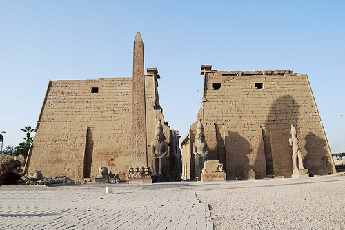
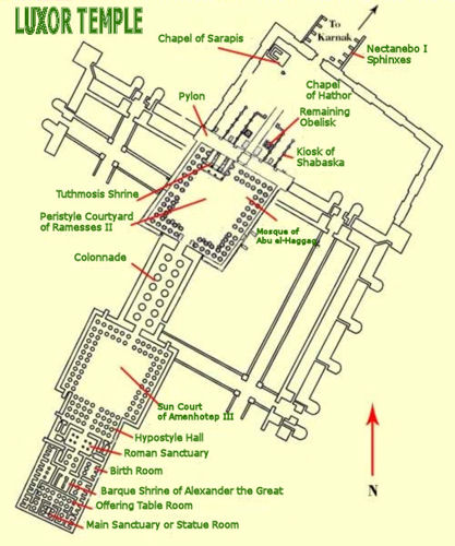
Luxor Temple
Built primarily by Amenhotep III (~1400 BCE) and expanded by Ramses II
(who added the massive pylon and statues). Dedicated to Amun, Mut, and
Khonsu, it emphasized kingship renewal rather than just worship. Unlike
Karnak's sprawling layout, this temple is more compact and linear,
aligned parallel to the Nile.
Key features: the Avenue of Sphinxes (a
2.7km/1.7-mile processional way lined with over 600 ram-headed sphinx
statues, recently fully excavated and reopened, linking it to Karnak),
the massive pylon with Ramses II battle scenes, a colonnaded court with
14 papyrus columns, and the inner sanctum. Later layers include
Roman-era additions (it became a fortress and church) and even a mosque
(Abu al-Haggag) built atop ancient ruins, showing 3,000+ years of
continuous sacred use.
Avenue of Sphinxes
This 2,700-meter
(1.7-mile) processional road, lined with sphinxes (some ram-headed, some
human), connected Karnak and Luxor Temples. Built and expanded over
centuries (18th–30th Dynasties), it hosted grand festivals with statues
of gods carried in procession. Fully restored and reopened in recent
years, it offers a powerful sense of ancient ritual processions.
West Bank: The Theban Necropolis and Mortuary Temples
The "City of
the Dead" stretches across the desert cliffs opposite modern Luxor.
Here, pharaohs, queens, nobles, and workers were buried in hidden
rock-cut tombs to ensure eternal life, while grand mortuary temples
(where the deceased king's cult was maintained) stood openly.
Valley of the Kings
The primary royal burial ground for New
Kingdom pharaohs (c. 1539–1075 BCE), hidden in a remote wadi (dry
valley) to deter robbers. Over 65 tombs have been discovered (including
KV62, Tutankhamun's, found intact in 1922 by Howard Carter). Tombs
feature descending corridors, chambers, and elaborate wall paintings
from the Book of the Dead, Book of Gates, and other afterlife
texts—depicting the pharaoh's journey through the underworld, judgment
by Osiris, and union with the gods.
Notable: Tutankhamun's small but
famous tomb (gold artifacts now mostly in Cairo's Grand Egyptian
Museum); larger ones like Seti I's (longest and most decorated) or
Ramses VI's. Many are off-limits for preservation, but open tombs
rotate. The valley's stark cliffs and heat emphasize the ancient
Egyptians' obsession with the afterlife.
Mortuary Temple of
Hatshepsut (Deir
el-Bahri)
One of the most architecturally innovative and visually
stunning sites in Egypt. Built by female pharaoh Hatshepsut (c.
1479–1458 BCE) and her architect Senenmut, this three-tiered terraced
temple rises dramatically against the cliffs at Deir el-Bahri. It was
dedicated to Amun and featured gardens, sphinx-lined ramps, colonnades,
and reliefs.
Highlights: The Punt Expedition reliefs (showing
Hatshepsut's trade voyage to modern Somalia/Eritrea, bringing myrrh
trees and exotic goods); scenes of her divine birth (claiming Amun as
her father); and Osiride statues. After her death, her successor
Thutmose III attempted to erase her name (though much survived). The
design influenced later temples and blends perfectly with the natural
landscape.
Colossi of Memnon
Two massive 18m (59ft)-tall
quartzite statues of Amenhotep III (c. 1390 BCE), once guarding his
now-lost mortuary temple (the largest ever built, later dismantled for
reuse). They depict the seated pharaoh and originally stood at the
entrance to his vast complex. After an earthquake (27 BCE), the northern
colossus "sang" at dawn due to wind vibrating through cracks—ancient
Greeks linked it to Memnon (son of Aurora) greeting his mother. The
sound stopped after Roman repairs.
Medinet Habu (Mortuary Temple
of Ramesses III)
A well-preserved mortuary temple of Ramesses III (c.
1186–1155 BCE), modeled after Ramses II's Ramesseum but with exceptional
detail. Features a massive first pylon with vivid battle reliefs
(including the pharaoh's victories over the Sea Peoples), a second
courtyard with Osiride pillars, and inner areas with colorful painted
reliefs of rituals and offerings. It includes a palace and sacred lake.
Often less crowded than other sites, it gives a complete picture of a
New Kingdom royal temple complex.
Other notable West Bank sites
Valley of the Queens: ~110 tombs for royal wives and princes;
Nefertari's (Ramses II's wife) is the most beautifully painted but
access is strictly limited.
Ramesseum: Ramesses II's mortuary temple,
famous for its fallen colossal statue (inspiring Shelley's
"Ozymandias").
Deir el-Medina: The workers' village that built the
royal tombs, with preserved houses and tombs offering insights into
everyday ancient Egyptian life.
Practical notes for visiting
Most sites require separate tickets (prices vary; a Luxor Pass covers
many for multi-day visits). Early mornings or late afternoons beat the
heat and crowds. A knowledgeable guide enhances understanding of the
hieroglyphs and context. Hot-air balloon rides over the West Bank at
sunrise offer breathtaking aerial views of the entire necropolis.
Sound-and-light shows at Karnak and Luxor Temple add a magical evening
dimension.
Luxor's economy is predominantly tourism-driven, generating revenue from site visits, Nile cruises, and activities like hot air balloon rides (introduced in 1988). Agriculture, including sugarcane, tomatoes, and pigeon farming, supplements income, alongside industries like pottery and handicrafts. Tourism employs many locals but has fluctuated due to events like the 1997 massacre, 2011 Arab Spring, and the 2013 balloon crash. Recovery post-COVID has been strong, with 2025 projections emphasizing eco-friendly initiatives. The sector contributes to Egypt's GDP, though challenges include overtourism straining sites and economic disparities. Community programs promote local guides and artisans, fostering sustainable growth.
Contemporary Luxor blends antiquity with modernity, featuring bustling souks, hotels ranging from luxury resorts like the Winter Palace to budget options, and infrastructure like Luxor International Airport facilitating global access. The city hosts cultural events, including the Luxor African Film Festival, and educational institutions preserving heritage. Recent developments include the 2021 unearthing of the "Lost Golden City," revealing insights into Amenhotep III's era, and ongoing restorations of the Avenue of Sphinxes, reopened in 2021 after decades of work. As of 2025, projects focus on digital mapping of sites for virtual tours, enhancing accessibility while reducing physical wear. Security has improved, though visitors are advised to follow advisories. Luxor's significance endures as a bridge between ancient wonders and modern Egypt, symbolizing cultural resilience and inspiring global fascination.