Location: 150 km South-west of Cairo Map
Wadi Al- Hitan or a Whale Valley ( وادي الحيتان) is situated some 150 km South West of Cairo. It is famous fo numerous fossils of ancient whales that are found here. Wadi Al- Hitan or Valley of the Whales is famous for full skeletons of whales that once swam here then this part of Africa was submerged under the sea. Evolution of a land based animal to a marine mammal is easily traceable by the fossils that are spread all around the region. It is no surprise that this part of Egyptian desert is named UNESCO World Heritage Site. Its isolation from most of human settlement gave chance to scientists discover and describe many whale species of Archaeocetes suborder. Known to palaeontologists as Dorudon Atrox, this ancient ancestor of modern whales is commonly found in the area. While its body shows characteristics of a marine animal, it still keeps its rudimentary hind limbs as well as skull and tooth design of a land animal.
Regional Geological Context and History
During the Eocene,
northern Egypt lay along the southern shoreline of the Tethys Sea (a
tropical, nutrient-rich embayment). Sea levels were generally high but
oscillated on third-order (∼1 million-year) cycles driven by eustasy,
including early Antarctic glaciation. This produced a
northward-prograding siliciclastic shelf with water depths ranging from
offshore (below storm wave base) to shoreface, embayment, and lagoonal
settings. Paleocurrents flowed west-northwest, and the shelf was partly
sheltered by an offshore island or barrier ∼50 km to the north.
Shorelines lay south and east of the modern site.
Post-Eocene uplift
from the southwest tilted the strata slightly and created paleodrainage
systems (now buried under sand) that fed mangrove-fringed estuaries and
lagoons near the modern Fayum area ∼37 Ma. The overall succession
records a long-term regressive trend from Middle Eocene maximum
transgression to early Oligocene maximum regression. Today, the nearly
flat-lying Eocene rocks form a low plateau that has been sculpted into
the iconic “Valley of Whales” landscape by arid-climate erosion.
Stratigraphic Framework
The exposed rocks at Wadi Al-Hitan belong to
three main Middle–Late Eocene formations (Bartonian–Priabonian stages).
They form a ∼110 m thick Priabonian section (with older Bartonian strata
below) that is mappable over hundreds of square kilometers. The
formations are, in ascending order:
Gehannam Formation (Middle
Eocene, Bartonian–early Priabonian, ∼41–38 Ma)
Lithology: Dominantly
open-marine mudstones, marly limestones, gypseous shales, and
clay/silt/sandy silt. These form the flatter ground east of the main
visitor area.
Depositional environment: Offshore to mid/outer neritic
shelf (below or near storm wave base) in a relatively deeper,
open-marine setting.
Fossil content: Abundant archaic whale
(archaeocete) skeletons (especially Basilosaurus isis), sirenians (sea
cows), shark teeth, turtles, crocodilians, and other marine vertebrates.
The formation yields many of the site’s earliest and most complete whale
remains.
Thickness and architecture: Interbedded with finer-grained
units; transitions eastward into deeper-water facies.
Birket
Qarun Formation (Late Eocene, Priabonian, ∼38–36.5 Ma)
Lithology:
Yellowish calcareous sandstones, bioturbated very fine- to fine-grained
sands, interbedded mudstones, and occasional hard limestones/coquinas.
These form the prominent cliffs and buttes that dominate the landscape.
A distinctive white layer riddled with animal burrows (originally
mistaken for mangrove roots) and an overlying black mudstone break the
sandstone monotony.
Depositional environment: Shallow open-marine
shoreface to transition zone (above normal wave base), with
storm-influenced hummocky cross-stratification (HCS), bioturbation
(Thalassinoides), and progradational sand bodies. The formation records
multiple phases of coastal sand-body progradation separated by
transgressive silts/clays.
Fossil content: Hosts the majority of
whale fossils (Basilosaurus isis and Dorudon atrox), often articulated
or semi-articulated. Other vertebrates (sharks, rays, bony fish) and
invertebrates are common. This unit is the primary “whale graveyard”
layer.
Qasr El-Sagha Formation (Late Eocene, late Priabonian,
∼39–36 Ma)
Lithology: Dark mudstones alternating with shell-rich
limestones/coquinas (nummulitids, turritellids, oysters, Carolia
placunoides marker bed at the base).
Depositional environment:
Shallow lagoonal, estuarine, and marginal-marine settings with
restricted circulation and oyster shoals.
Fossil content: Rich in
marine invertebrates; fewer whales but more dugongs and marginal-marine
vertebrates. Represents the final shallowing phase before full
regression.
Sequence Stratigraphy and Depositional History
Detailed work (especially Peters et al. 2009 and King et al. 2014) shows
the Priabonian section is divided into third-order sequences
(TA4.1–TA4.3) bounded by major sequence boundaries (Pr-1 to Pr-4). These
reflect ∼45 m eustatic sea-level falls and rises, producing
parasequences (shallowing-upward cycles 3–10 m thick) and systems tracts
that directly control fossil preservation.
Transgressive Systems
Tract (TST): Mudstone–sandstone parasequences with marine flooding
surfaces (MFS). Low net sedimentation rates create condensed intervals
ideal for accumulating whale carcasses (mostly Basilosaurus in offshore
settings).
Highstand Systems Tract (HST): Thick, coarsening-upward
muddy sections with HCS; higher sedimentation dilutes fossils.
Falling-Stage Systems Tract (FSST): Bioturbated shoreface sandstones;
articulated Dorudon skeletons preserved on cycle tops.
Sequence
Boundary (SB) & Incised Valley Fill (IVF): Erosional lags with pebble
conglomerates and incised valleys (up to 70 m relief) filled with tidal
rhythmites and clinoforms. These contain reworked, fragmented bones
(including rare terrestrial mammals) and record subaerial exposure.
Ravinement Surfaces (RS): Shell lags with corals and dugong remains mark
subsequent transgressions.
Whale skeletons are preferentially
preserved in condensed sections on MFS and RS because of low
sedimentation, environmental averaging, and rapid burial by storms.
Taxonomic composition shifts with water depth: larger Basilosaurus in
deeper offshore facies, smaller Dorudon in shallower shoreface settings.
No mass-mortality events are evident; preservation reflects steady
carcass input plus sequence architecture.
Modern Geomorphology
and Exposure of Fossils
The flat-lying Eocene strata have been
dissected by wind (the dominant agent in the hyper-arid desert) and
episodic water erosion into spectacular cliffs, buttes, conical hills,
pillars, and globular concretions (“battikh”). The softer mudstones
erode into badlands, while resistant sandstones form steep cliffs.
Ongoing erosion slowly exhumes new fossils from shallow burial while
exposing older ones to the elements—some are protected with polymer
embedding. This dynamic process makes Wadi Al-Hitan a “living”
geological laboratory where new discoveries continue.
Geological and Historical Context
Located in the Faiyum
Governorate within the Wadi El-Rayan Protected Area (about 150 km
southwest of Cairo), Wadi Al-Hitan spans roughly 200 km² of arid,
wind-sculpted desert landscape. Around 40–36 million years ago (late
Eocene, primarily Gehannam Formation ~40–41 Ma and Birket Qarun
Formation), this area was a shallow, nutrient-rich coastal bay of the
ancient Tethys Sea, with nearshore marine environments, lagoons, and
possible mangrove forests. Sediments accumulated as sea levels
fluctuated, entombing marine vertebrates in fine-grained deposits that
eroded today to expose fossils on or near the surface.
The site was
first noted in 1902–1903, with major excavations resuming in the 1980s.
Over 1,000 whale individuals have been identified (hundreds of
near-complete skeletons), making it the largest and best-preserved
archaeocete “graveyard” on Earth. Fossils are often shallowly buried and
naturally uncovered by erosion, allowing in-situ study in their original
geological setting.
The Star Fossils: Archaeocete Whales
The
site’s fame rests on basilosaurid archaeocetes—fully aquatic but
retaining primitive traits. These whales had streamlined bodies like
modern cetaceans yet kept land-mammal-like skull and tooth features,
plus small hind limbs with feet and toes (a surprise discovery here).
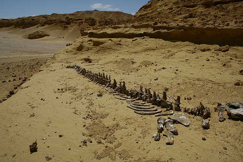
Basilosaurus isis (the most abundant and iconic): The largest,
reaching 15–21 m long with a serpentine, eel-like body. It was a top
predator with a powerful skull, heterodont teeth (varied shapes for
gripping and shearing, akin to carnivorous land mammals), and
five-fingered forelimb flippers. Crucially, it possessed tiny,
non-weight-bearing hind limbs (thigh, shin, ankle, and toe
bones)—vestigial but possibly used as claspers during mating. Skeletons
often lie fully articulated on the sand, ribs splayed like fallen
pickets. Evidence from stomach contents and bite marks shows it preyed
on young Dorudon calves (and fish), confirming it as an apex predator in
a calving-ground ecosystem.
Dorudon atrox: Smaller and more
dolphin-like (3–5 m long), with a compact body, shorter snout, and
similar transitional features (hind limbs, flippers). More modern in
form than Basilosaurus but still with archaeocete dentition. The site is
interpreted as a nursery area where Dorudon calved, making calves easy
prey for larger Basilosaurus.
At least two rarer archaeocete
species are present. Over 400–1,500 marine vertebrate skeletons (mostly
whales) represent the highest concentration and quality of intact
archaeocete fossils anywhere.
Evolutionary highlight: These fossils
capture the “last gasp” of hind-limb retention in whales. Earlier
archaeocetes (like Pakicetus or Ambulocetus) had functional legs for
walking/swimming; by the late Eocene in Wadi Al-Hitan, limbs were
reduced to tiny, non-functional stubs—vivid proof of the land-to-sea
shift.
Accompanying Fossil Assemblage and Paleoecology
Wadi
Al-Hitan is not just about whales. It yields a rich ecosystem snapshot:
Sirenians (sea cows): Complete skeletons of at least three species,
early fully aquatic herbivores related to modern manatees/dugongs.
Other marine vertebrates: Diverse sharks and rays (abundant teeth,
including sawfish), bony fish, turtles, crocodiles, and even sea snakes.
Terrestrial/mammalian links: Bones of Moeritherium (a primitive,
hippo-like early proboscidean/elephant relative) and the oldest known
pelican.
Invertebrates and plants: Thousands of coin-shaped
nummulites (foraminifera), mollusc shells, and mangrove-root
traces—indicating a productive coastal habitat.
Taphonomic
studies reveal “whale-fall” communities (bones supporting specialized
scavengers) and excellent preservation due to rapid burial in shallow
marine muds.
Modern Significance and Visitation
Today, about a
dozen skeletons are accessible along visitor trails. The on-site Fossil
and Climate Change Museum houses an 18 m Basilosaurus skeleton amid
displays on whale evolution and climate impacts. The site remains
protected, with ongoing research (e.g., by teams led by Philip Gingerich
and Egyptian paleontologists).
Wadi Al-Hitan stands as a global
reference for cetacean evolution—unique in its fossil density, quality,
accessibility, and contextual setting. It vividly illustrates how
whales, once terrestrial, became the ocean’s giants, with every exposed
rib and tiny toe bone telling that 40-million-year-old story.
There are only 1,000 visitors a year who travel to Wādī al-Ḥītān by
4WD as the track is not asphalted and crosses desert sands. For the most
part, visitors to Wādī al-Ḥītān are foreigners who usually frequent the
valley during winter weekends. Because Wādī al-Ḥītān is within the Wādī
al-Rayān protected area, the site's conservation program funnels
visitors along a prescribed route. Sustainable tourism is starting to
develop and grow in the area, while visits on board four-wheel drive
vehicles are alternatively replaced by walks on foot or on dromedaries.
Since part of Wādī al-Ḥītān has been transformed into a tourist
site, some walkways have been placed to connect the places where the
main fossils are found and small shelters have also been built. This
public park is now regularly visited by tourist groups and there is also
a small campsite.
The valley lies behind a mountain, known as
Qārat Gahannam (Arabic قارة)?, Qārat) means "hill" or "mountain" and
Gahannam, Arabic ﺟﻬﻨﻢ?, means "hell", so Qārat Gahannam means "
mountain of hell". In the light of the sunset, the mountain seems to be
ablaze with a frightening red light.
The Egyptian government said
that in July 2007 two cars driven by Belgian diplomats entered a
protected zone in this sector and this caused US$10 million in damage to
the fossils. The Belgian government declared, however, that no damage
was caused by its diplomats. The problem still remains unsolved.