Location: Western Province Map
Area: 230 sq km
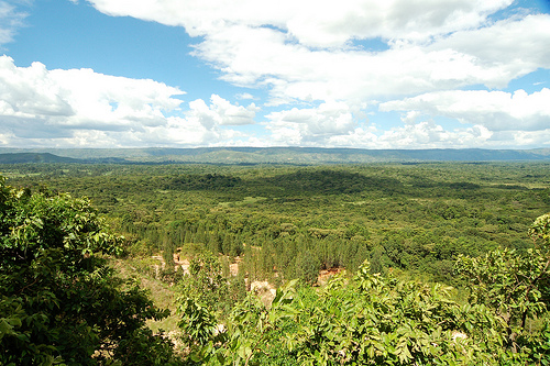
Kakamega Forest National Reserve, located in western Kenya’s Kakamega and Nandi Counties, approximately 35 kilometers northeast of Kisumu and 400 kilometers from Nairobi, is a unique ecological treasure. Covering about 240 square kilometers, with the core 45 square kilometers gazetted as a national reserve in 1985, it is Kenya’s only tropical rainforest and a remnant of the ancient Guineo-Congolian forest that once stretched across Central Africa. Managed by the Kenya Wildlife Service (KWS) and the Kenya Forest Service (KFS), the forest is renowned for its exceptional biodiversity, including rare primates, over 400 bird species, and unique flora. Its cultural significance to the Luhya people, who call it “Kisere” or “Buyangu,” and its role as a biodiversity hotspot make it a critical site for conservation, research, and eco-tourism.
Kakamega Forest lies at an elevation of 1,500–1,700 meters in
the Lake Victoria Basin, on the eastern edge of the Central
African rainforest belt. The forest’s geology is shaped by
ancient granitic and volcanic rocks, overlaid with fertile,
well-drained loamy soils that support dense vegetation. Its
location near Lake Victoria creates a humid, equatorial climate,
with average temperatures of 20–28°C and high annual rainfall of
1,200–2,000 mm, distributed across two rainy seasons: the long
rains (March–May) and short rains (October–November). The dry
season (December–February) is optimal for visiting due to
clearer trails and reduced mosquito activity.
The
forest’s topography is gently undulating, with small hills,
river valleys, and granite outcrops like Buyangu and Lirhanda
Hills. Several rivers, including the Isiukhu, Yala, and Lusumu,
originate in the forest, feeding into Lake Victoria and
supporting lush riverine ecosystems. The forest canopy, reaching
20–40 meters, creates a shaded, humid microclimate that sustains
diverse flora and fauna, distinguishing Kakamega from Kenya’s
savanna-dominated parks.
The forest comprises several
ecological zones:
Primary Rainforest: Dense, tall trees like
Elgon teak (Olea capensis), red stinkwood (Prunus africana), and
African satinwood (Funtumia africana) dominate, with a thick
understory of ferns, lianas, and epiphytes.
Secondary Forest:
Regenerating areas with younger trees and shrubs, often near
human settlements.
Grasslands and Clearings: Small patches,
some maintained by KFS, support sun-loving species and grazing
wildlife.
Riverine Forests: Lush vegetation along rivers,
with figs, palms, and wild bananas.
Kakamega Forest is a biodiversity hotspot, hosting over 1,250
plant species, 400 bird species, 490 butterfly species, and
numerous mammals, reptiles, and amphibians. Its isolation as a
forest “island” amid agricultural land has preserved endemic and
rare species, making it a priority for conservation.
Flora:
The forest contains 150–200 tree species, including
economically valuable timber trees like Elgon teak, African
mahogany (Khaya anthotheca), and red stinkwood, as well as
medicinal plants like Prunus africana (used for prostate
treatment). Orchids, ferns, and epiphytes thrive in the canopy,
with 60 orchid species recorded.
Endemic plants include the
Senecio kakamegensis (a groundsel) and various lianas. The
forest’s dense undergrowth supports a rich herbaceous layer,
vital for pollinators.
Mammals:
Primates are a
highlight, with five species: the endangered De Brazza’s monkey
(known for its white beard), blue monkey, red-tailed monkey,
black-and-white colobus, and vervet monkey. The potto (a
nocturnal prosimian) and bushbaby (galago) are elusive but
present.
Other mammals include bushbucks, duikers (blue and
red), bushpigs, giant forest hogs, civets, genets, mongooses,
and African clawless otters along rivers. Leopards and servals
are rare, and the forest’s small size limits large herbivore
populations.
Bats, such as the false vampire bat and fruit
bat, are abundant, playing a key role in seed dispersal.
Birds:
Kakamega is a premier birdwatching destination, with
400–450 species, including 40–60 found only in this forest in
Kenya. Notable species include the great blue turaco,
black-and-white casqued hornbill, grey parrot, Turner’s
eremomela (endangered), Chapin’s flycatcher, blue-headed
bee-eater, African emerald cuckoo, white-spotted flufftail, and
red-chested owlet.
The forest is an Important Bird Area
(IBA), with migratory species like the African pitta and
resident rarities like the yellow-bellied wattle-eye. Early
morning walks maximize sightings.
Reptiles and
Amphibians:
Snakes include the forest cobra, Gaboon viper,
green mamba, and gold’s tree cobra (endemic to Kakamega).
Lizards like agamas, skinks, and chameleons are common.
Amphibians thrive in the humid environment, with species like
the Kakamega forest tree frog and various toads. The forest’s
streams and pools are critical breeding sites.
Insects:
Kakamega hosts 490 butterfly species, including the rare
*Charaxes nandina and *Euphaedra rex. The forest’s Goliath
beetle, emperor moths, and ant swarms (Dorylus ants) are
notable.
Pollinators like bees and beetles support the
forest’s plant diversity.
Kakamega Forest offers a serene, immersive experience,
emphasizing nature walks, birdwatching, and cultural engagement over
traditional game drives. Its dense canopy and rich biodiversity make
it ideal for eco-tourism and scientific exploration. Key attractions
and activities include:
Guided Nature Walks:
Over 20
kilometers of trails wind through the forest, ranging from 2–10 km.
Popular routes include the Isiukhu Falls Trail (to a scenic
waterfall), Buyangu Hill Trail (for panoramic views), and Lirhanda
Hill Trail (for birdwatching).
Guided walks, offered by KWS or
local guides, reveal primates, birds, and plants. Night walks
highlight nocturnal species like bushbabies, owls, and glowing
fungi.
Birdwatching:
Kakamega is Kenya’s top birding
destination, with guided tours targeting rare species. The Ikuywa
River area and Yala River trail are hotspots. Binoculars and early
starts (6–9 AM) are recommended.
Butterfly Viewing:
The
forest’s clearings and riverbanks are ideal for spotting
butterflies. The Kakamega Forest Butterfly Project offers guided
tours, showcasing species like the African swallowtail and
cream-banded charaxes.
Hiking and Viewpoints:
Buyangu Hill
(1,650 m) and Lirhanda Hill offer viewpoints with vistas over the
canopy and distant Nandi Hills. Trails to these hills are moderately
strenuous, taking 1–3 hours.
Isiukhu Falls, a small but
picturesque waterfall, is a refreshing stop after a hike.
Cultural Experiences:
The forest is sacred to the Luhya people,
who use it for rituals and harvesting medicinal plants. Visitors can
engage with Luhya communities in nearby villages like Shinyalu or
Khayega, learning about traditional dances, storytelling, and crafts
like basket weaving.
The Kakamega Environmental Education
Programme (KEEP) organizes cultural tours and community visits.
Photography:
The forest’s misty canopy, vibrant birds, and
cascading rivers provide stunning photo opportunities. Macro
photography captures butterflies, orchids, and fungi, while sunrise
shots from Buyangu Hill are iconic.
Scientific and
Educational Tours:
Research stations like the Isecheno Forest
Station and Rondo Retreat Centre support studies on biodiversity and
conservation. Visitors can join guided tours to learn about ongoing
research.
Kakamega Forest is a critical conservation site, recognized as a Key
Biodiversity Area (KBA) and part of the UNESCO Man and Biosphere Reserve
network. Its isolation makes it vulnerable, and conservation efforts
focus on preserving its unique ecosystem. Key challenges include:
Deforestation and Encroachment: Historical logging and conversion to
farmland reduced the forest from 1,000 km² to 240 km². Illegal logging,
charcoal burning, and grazing continue to threaten the forest,
particularly in non-gazetted areas.
Poaching: Bushmeat hunting
targets duikers and bushbucks, while snares harm primates. KWS patrols
aim to curb this.
Human-Wildlife Conflict: Surrounding communities
face crop raids by monkeys and bushpigs, leading to tensions. KEEP
promotes coexistence through education and alternative livelihoods.
Invasive Species: Introduced plants like Lantana camara compete with
native flora, requiring management.
Climate Change: Altered rainfall
patterns and rising temperatures threaten the forest’s
humidity-dependent species.
Conservation initiatives include:
Reforestation: KFS and NGOs like KEEP plant indigenous trees to restore
degraded areas.
Community Engagement: Programs train locals as
guides, beekeepers, and conservationists, providing income from
eco-tourism. The Kakamega Forest Guides Association ensures sustainable
tourism.
Research and Monitoring: Institutions like the National
Museums of Kenya and International Centre of Insect Physiology and
Ecology (ICIPE) study biodiversity, informing conservation strategies.
Eco-Tourism: Revenue from entrance fees and lodges supports patrols and
community projects.
Kakamega Forest is deeply intertwined with Luhya culture. The forest
is a spiritual site for the Luhya, who believe it houses ancestral
spirits. Traditional healers harvest medicinal plants, and sacred groves
are used for ceremonies. The forest’s name, derived from the Luhya word
“kakamega” (meaning “pinch” or “squeeze,” possibly referring to dense
vegetation), reflects its cultural embeddedness.
Historically,
the forest was a trade and migration route, with evidence of Bantu
settlement dating back centuries. Colonial-era logging in the early 20th
century reduced its size, but conservation efforts since the 1960s have
prioritized its protection. The forest’s global significance is
highlighted by its role in biodiversity research and its appeal to
international birders and primatologists.
Access:
By Road: From Nairobi (400 km, 6–7 hours), take the A104
to Nakuru, then the A1 to Kisumu, and the C39 to Kakamega town. From
Kisumu (35 km, 1 hour), the C39 leads to the forest. Public matatus from
Kakamega town to Isecheno or Buyangu are affordable but require a short
walk to the entrance. A 4x4 is recommended during the wet season.
By
Air: Flights from Nairobi’s Wilson Airport to Kakamega Airstrip (15 km
from the forest) are available via Safarilink or Fly540. Kisumu
International Airport (50 km) is an alternative, followed by a road
transfer.
By Bus: Buses from Nairobi or Kisumu to Kakamega town are
budget-friendly, with taxis or boda-bodas (motorbikes) to the forest.
Best Time to Visit:
The dry season (December–February) offers
clear trails, fewer mosquitoes, and optimal birdwatching. The wet
seasons (March–May, October–November) bring lush greenery but muddy
paths and leech risks.
Entry Fees:
Paid via the KWS e-Citizen
platform (https://kws.ecitizen.go.ke) using M-Pesa, Airtel Money, or
cards. Non-residents pay approximately USD 20–25 (adults) and USD 10–15
(children); Kenyan residents pay less. Guide fees (USD 5–10) and camping
fees apply separately.
Accommodation:
Inside the Forest:
Udo’s Bandas (KWS): Basic cottages near Isecheno, with shared bathrooms
(USD 20–30/night).
KWS Campsites (Buyangu, Isecheno):
Budget-friendly, with basic facilities (USD 5–10/night).
Rondo
Retreat Centre: A serene, mid-range lodge with colonial-style cottages,
gardens, and meals (USD 80–150/night, full board).
Nearby:
Kakamega Town: Budget hotels like Golf Hotel or Sheywe Guest House (USD
20–50/night).
Kisumu: Mid-range and luxury options like Acacia
Premier Hotel or Sovereign Hotel (USD 80–200/night).
Activities
and Tips:
Hire a guide from the Kakamega Forest Guides Association
for safety and expertise (available at Isecheno or Buyangu).
Bring
binoculars, a raincoat, insect repellent, and sturdy boots; leech socks
are advised during the wet season.
Start walks early (6–7 AM) for
bird and primate sightings.
Combine visits with Lake Victoria,
Kisumu’s Impala Sanctuary, or the Crying Stone of Ilesi.
Respect
Luhya cultural sites and seek permission before photographing locals.
Scientific and Global Impact
Kakamega Forest is a global research hub, with studies on primate
behavior, bird ecology, and forest regeneration conducted by
institutions like the University of Nairobi, Smithsonian Institution,
and Max Planck Institute. Its role as a carbon sink and water catchment
underscores its environmental importance. The forest’s biodiversity data
informs global conservation policies, and its endemic species highlight
the urgency of protecting tropical forest fragments.
As an
eco-tourism destination, Kakamega offers a low-impact alternative to
Kenya’s crowded savanna parks, attracting birders, researchers, and
nature enthusiasts. Its community-based conservation model is a
blueprint for balancing human needs with ecosystem preservation, earning
recognition from organizations like BirdLife International.