Location: Map
Area: 50 mi² (130 km²)
Lake Baringo, located in Kenya’s Great Rift Valley in Baringo County, is one of the northernmost freshwater lakes in Kenya’s Rift Valley system. Roughly 130 km northeast of Nakuru and 270 km northwest of Nairobi, it lies at an altitude of about 970 meters above sea level. Covering approximately 130 square kilometers with an average depth of 5–6 meters, it is a critical ecological and cultural hub despite challenges like siltation, climate change, and human encroachment. Known for its rich biodiversity, vibrant local communities, and striking landscapes, Lake Baringo is a Ramsar Wetland of International Importance (designated in 2002) and a popular destination for ecotourism, birdwatching, and cultural exploration.
Lake Baringo is a rift lake formed by tectonic
activity in the East African Rift System millions of years ago. Unlike
many Rift Valley lakes, it is freshwater, with a pH of around 8.5, due
to inflows from rivers and underground springs. Its primary tributaries
are the Molo, Perkerra, and Ol Arabel rivers, originating in the Mau
Escarpment and Aberdare Ranges. The lake has no visible outlet, with
water loss attributed to evaporation and subterranean seepage, possibly
feeding nearby Lake Bogoria. Its water levels fluctuate significantly
due to seasonal rains and prolonged droughts, with notable reductions in
dry periods exposing large areas of the lakebed.
Siltation is a
major issue, driven by deforestation and overgrazing in the catchment
areas, which increases sediment loads in feeder rivers. This has reduced
the lake’s depth over time, with some areas now as shallow as 1–2
meters. Water quality is also affected by agricultural runoff and
occasional algal blooms, though the lake remains potable in many areas.
Lake Baringo is an ecological hotspot, supporting
diverse flora and fauna adapted to its dynamic environment.
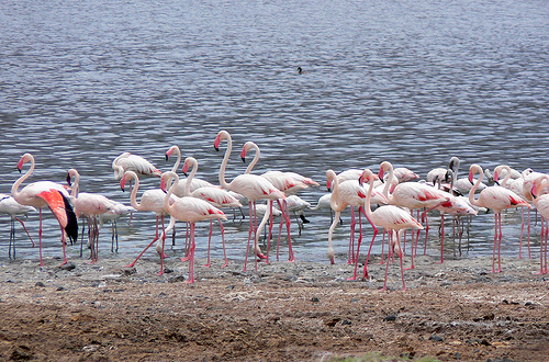
Birdlife: The lake is a premier birdwatching destination, hosting over
470 species, earning it recognition as an Important Bird Area by
BirdLife International. Notable species include the African fish eagle,
Goliath heron, white-faced whistling duck, and migratory birds like the
Madagascar squacco heron. Ol Kokwe Island, the lake’s largest island, is
a key roosting and breeding site for birds like cormorants and pelicans.
Aquatic Life: The lake supports seven fish species, with the most
abundant being the Baringo tilapia (Oreochromis niloticus baringoensis),
a subspecies unique to the lake, and lungfish. Overfishing and
introduced species like tilapia from Lake Victoria threaten native
populations. Nile crocodiles and hippopotamuses are prominent, with an
estimated 100–150 hippos and numerous crocodiles, though their numbers
have declined due to habitat loss and human-wildlife conflict.
Mammals and Reptiles: Surrounding acacia woodlands and grasslands host
vervet monkeys, olive baboons, warthogs, and occasional leopards. The
lake’s shores are home to monitor lizards and non-venomous snakes like
the African rock python.
Vegetation: The lake’s edges feature papyrus
reeds, water hyacinth (an invasive species), and submerged macrophytes,
while the surrounding landscape includes acacia savanna, doum palms, and
desert rose plants. Volcanic islands like Ol Kokwe support unique
microhabitats with hardy shrubs and grasses.
The lake’s ecosystem
faces threats from invasive species, overgrazing, and climate-induced
water level changes. Conservation efforts, supported by organizations
like the Lake Baringo Conservation Network, focus on reforestation,
sustainable fishing, and community-based ecotourism.
Lake Baringo is surrounded by diverse ethnic
communities, including the Ilchamus (Njemps), Tugen, Pokot, and Turkana,
each with distinct cultural practices and livelihoods.
Ilchamus
(Njemps): A Maa-speaking group related to the Maasai, the Ilchamus are
semi-nomadic pastoralists who also fish, a rare practice among Maa
peoples. They use traditional papyrus reed boats (ambach), the only such
boats in Kenya, for fishing and transport. Their diet includes tilapia
and milk, and they live in semi-permanent manyattas (homesteads).
Tugen and Pokot: These Kalenjin-speaking groups engage in farming
(maize, millet, and vegetables) and livestock herding. The Tugen,
dominant in Baringo County, also operate small businesses catering to
tourists.
Turkana: Present in smaller numbers, they are pastoralists
who occasionally fish and trade livestock.
The lake supports about
15,000–20,000 people directly through fishing, tourism, and agriculture.
Key settlements include Kampi ya Samaki on the western shore, a bustling
fishing village, and Loruk and Komolion on the northern and eastern
shores. The Ilchamus dominate the lake’s islands, with Ol Kokwe hosting
a small community.
Cultural attractions include Ilchamus dances,
storytelling, and visits to traditional homesteads. The annual Lake
Baringo Festival, held in November, showcases local music, crafts, and
boat races, drawing visitors and fostering community pride.
Lake Baringo’s region has yielded fossils indicating human habitation dating back millions of years, though no major archaeological sites are directly tied to the lake itself. The area was a crossroads for pastoralist migrations, with the Ilchamus settling around the 19th century. Colonial records from the late 19th century describe the lake as a trading hub for ivory and livestock. In the 20th century, British colonialists established administrative posts, and the lake became a focus for early conservation efforts.
Lake Baringo is a growing ecotourism destination, offering diverse
activities:
Boat Safaris: Guided boat trips (KES 2,000–5,000 per
boat) explore islands like Ol Kokwe, Gibraltar, and Parmalok, where
visitors spot hippos, crocodiles, and birds. Sunset cruises are popular
for their scenic views.
Birdwatching: Guided walks or boat-based
birding tours (KES 1,000–2,000 per person) target species like the
Hemprich’s hornbill and Verreaux’s eagle. The lake’s shores and Ruko
Conservancy are prime spots.
Cultural Tours: Visits to Ilchamus
villages on Ol Kokwe or the mainland offer insights into traditional
fishing, boat-making, and crafts (KES 500–1,500 per person).
Reptile
Park: Near Kampi ya Samaki, Roberts’ Camp hosts a reptile park with
snakes like puff adders and cobras, educating visitors on local
herpetofauna (entry KES 500).
Hiking and Nature Walks: Trails around
the lake and in Ruko Conservancy reveal volcanic landscapes, hot
springs, and wildlife (guided walks KES 1,000–2,000).
Island
Exploration: Ol Kokwe, a volcanic island, features hiking trails,
Ilchamus homesteads, and panoramic lake views. Smaller islands like
Devil’s Island are steeped in local folklore.
Fishing: Recreational
fishing for tilapia is available, though regulated to protect stocks.
Accommodations range from luxury lodges like Samatian Island Lodge (KES
20,000–50,000 per night) to budget campsites like Roberts’ Camp (KES
1,000–3,000 per night). Dining options include fresh tilapia dishes and
Swahili cuisine at local restaurants.
Siltation and Water Loss: Deforestation and erosion in the catchment
area reduce the lake’s depth and capacity, with sediment loads doubling
since the 1980s. Droughts exacerbate water scarcity.
Human-Wildlife
Conflict: Hippos and crocodiles occasionally attack fishermen or
livestock, leading to retaliatory killings. Community education programs
aim to mitigate this.
Overfishing: Unsustainable practices threaten
fish stocks, prompting regulations like mesh size limits and seasonal
bans.
Invasive Species: Water hyacinth clogs waterways, affecting
fishing and navigation. Manual removal and biological controls are
ongoing but insufficient.
Climate Change: Erratic rainfall and rising
temperatures alter water levels and ecosystems, with a 20% reduction in
lake volume during severe droughts (e.g., 2009–2011).
Infrastructure:
Poor road access, especially during rains, limits tourism. The
Marigat-Kampi ya Samaki road is often impassable without 4WD vehicles.
Access: From Nairobi, drive via Nakuru (4–5 hours, 270 km) or fly to
Eldoret (1 hour) and drive 2 hours. Public matatus from Nakuru to Kampi
ya Samaki cost KES 500–800. The nearest airstrip is at Lake Baringo
Airport for private charters.
Best Time: June–October (dry season)
for wildlife viewing and accessibility; November–March for bird
migration. April–May (rainy season) offers lush scenery but muddy roads.
Entry: No entrance fee for the lake, but boat trips, conservancy visits
(e.g., Ruko, KES 2,000), and cultural tours have costs. Check with local
operators for updated prices.
Tips: Bring binoculars for
birdwatching, insect repellent, and sturdy shoes for walks. Hire local
guides for safety and cultural insights. Respect wildlife, especially
hippos and crocodiles, by maintaining distance during boat trips.
Combine Visits: Pair with Lake Bogoria (40 km south) for geysers and
flamingos, or the Kerio Valley for scenic hikes.
The Lake Baringo Conservation Network and local groups like the
Ilchamus Community Conservation Group promote sustainable practices:
Reforestation to reduce siltation, with over 10,000 trees planted
since 2015.
Community-based tourism, where 70% of revenue from tours
supports local schools and health clinics.
The Ruko Community
Wildlife Conservancy, established in 2009, protects 3,000 hectares of
lake-adjacent habitat, benefiting species like the endangered
Rothschild’s giraffe.
Fishing cooperatives enforce sustainable
practices, though compliance is uneven.