Location: Map
When: September
Duration: 3 weeks
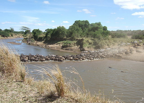
The Mara River Crossing is one of the most iconic and dramatic events of the Great Migration, a year-round movement of approximately 1.5–2 million wildebeest, 200,000–800,000 zebras, and thousands of gazelles and other ungulates across the Serengeti-Masai Mara ecosystem in Tanzania and Kenya. Occurring primarily between July and October, with a return crossing from October to November, this perilous journey across the Mara River is a life-and-death spectacle where herds brave treacherous currents, steep banks, and predators like Nile crocodiles, lions, and leopards. The crossing, often described as nature’s ultimate test of survival, draws thousands of tourists to the Masai Mara National Reserve (Kenya) and Serengeti National Park (Tanzania), offering a visceral experience of raw wilderness.
The Mara River, stretching 395 kilometers from its
source in Kenya’s Mau Escarpment (2,932 meters elevation) to its
terminus in Lake Victoria (1,134 meters), is the final and most
formidable barrier in the Great Migration’s northern leg. The river’s
basin spans 13,504 km², with 65% in Kenya and 35% in Tanzania, cutting
through the Masai Mara National Reserve and Serengeti National Park. Its
meandering path, marked by steep embankments, rocky outcrops, and
variable depths, creates a dynamic obstacle for migrating herds.
Hydrology and Flow: During the dry season (July–October), the river may
appear shallow, but heavy rains can double its size, creating rapids and
strong currents. Flash floods, as seen in 2018 and 2020, alter its
course and crossing points, increasing risks like drowning or missing
exit points. The river’s depth, even in the dry season, supports hippo
pods and Africa’s largest population of Nile crocodiles, adding to the
crossing’s danger.
Crossing Points: Over a dozen named crossing
points exist, numbered 0–10 in the Serengeti and including key sites in
the Masai Mara like Cul de Sac, Paradise Plains, Serena’s Crossing,
Lookout Hill, and Kichwa Tembo. Each point varies in terrain:
Steep
and Rocky: Points like No. 4, No. 5, and Cul de Sac feature high banks
(up to 10 meters) and boulder-strewn riverbeds, leading to high
mortality from falls or trampling.
Gentler Slopes: Points like
Serena’s Crossing and Kichwa Tembo have shallower banks, reducing
physical risks but not predator threats.
Open vs. Wooded: Open points
like Lookout Hill offer better visibility for tourists, while wooded
areas like Mortuary Crossing conceal predators, increasing drama.
Climate Influence: The migration follows rainfall patterns, with herds
tracking green grass and water. Unexpected rains or droughts can shift
crossing timing by weeks, making July–August the peak but
September–October viable for late crossings. Flooding can block
crossings, while low water levels expose herds to crocodiles.
The Mara River Crossing is the climax of the Great
Migration, a 3,000-kilometer annual cycle driven by the search for food,
water, and breeding grounds. The river represents a bottleneck where
instinct, herd behavior, and predation converge.
Herd Behavior:
Buildup and Hesitation: Herds gather in tens of thousands, sometimes for
hours or days, at crossing points, displaying nervous indecision.
Wildebeest mill about, braying hysterically, with false starts triggered
by minor stimuli like a gust of wind or a zebra’s movement. This
hesitation stems from assessing risks like steep banks, fast currents,
or predator presence.
Trigger and Stampede: A single brave wildebeest
or zebra leaping into the river can spark a chaotic surge, with
thousands charging shoulder-high through the water. The stampede is
visually and acoustically overwhelming, raising dust clouds and echoing
with grunts and splashes.
Crossing Strategy: Zebras often lead, their
sharper senses detecting safer paths, while wildebeest follow in dense
formations. Calves stay close to mothers, but separation is common in
the frenzy. Herds prefer gentler banks but may choose “suicidal” points
under pressure, leading to mass drownings.
Predation:
Nile
Crocodiles: The Mara’s crocodiles, some over 50 years old, feed
primarily during crossings, targeting stragglers or injured animals.
Attacks are swift, with crocodiles weaving through the herd to snatch
wildebeest or zebras, though many are sated from earlier feasts.
Terrestrial Predators: Lions, leopards, hyenas, and cheetahs stalk
riverbanks, ambushing exiting herds at wooded or eroded points. Lions
exploit bottlenecks, killing weakened animals, while leopards rarely
succeed due to lion competition.
Hippos: Hippos, submerged in deep
pools, can be unpredictable, occasionally attacking wildebeest or even
rescuing them from crocodiles, though their presence may deter
crocodiles at some crossings.
Mortality: Thousands perish annually
from drowning, trampling, or predation. High-water crossings sweep away
herds, while rocky banks cause broken legs or crushing. Estimates
suggest 500–5,000 deaths per major crossing, with bodies piling up
downstream, attracting vultures and scavengers.
Ecological Role: The
crossing sustains the ecosystem by providing food for predators and
scavengers and fertilizing riverbanks with carcasses. It also connects
the Serengeti-Masai Mara food web, with the river feeding Lake
Victoria’s basin, supporting regional biodiversity.
The Mara River’s crossing points are mapped by park rangers and
tour operators, with each offering unique challenges and viewing
opportunities. Below are notable points, based on available data:
Serengeti (Tanzania):
No. 1–4 (Western Points): Near the
Lamai Triangle, these points are used by western herds from
July–August. Steep banks and fast currents make them dramatic, with
high crocodile activity. Ideal for viewing from the Lamai side.
No. 5–6: Rocky and predator-heavy, these are among the most
dangerous, with frequent lion ambushes. Best for dramatic
photography but crowded with vehicles.
No. 8, Makutano, No. 10:
Early-season crossings (June–July) by eastern bachelor herds.
Gentler slopes but strong currents. Less crowded, offering intimate
views.
Sand River Crossing: A tributary crossing near the Mara’s
confluence, used in June–July. Shallower but still risky due to
crocodiles.
Masai Mara (Kenya):
Cul de Sac Crossing:
Narrow channel with steep banks, creating chaotic stampedes and
frequent crocodile attacks. Peak viewing in August–September, near
Mara Serena Lodge.
Paradise Plains Crossing: Open terrain with
large herds, ideal for photographers. High predator activity on
riverbanks.
Serena’s Crossing: Consistent and accessible, with
calmer waters but lion and hyena presence. Popular due to proximity
to lodges.
Lookout Hill Crossing: Early August hotspot with open
visibility and smaller crossings. High crocodile activity.
Kichwa
Tembo Crossing: Late-season (September–October) point with gentler
slopes, offering quieter safaris. Scenic and less crowded.
Mortuary Crossing: Named for high mortality, used during the
southward migration (October–November). Predator hotspots make it
intense.
The Mara River Crossing holds deep cultural resonance for the Maasai,
who inhabit the region and call the river “Mara,” meaning “spotted” or
“mottled,” possibly referencing its turbulent waters or surrounding
plains. The migration is woven into Maasai folklore, symbolizing
resilience and the cycle of life. The river’s banks are used for grazing
and rituals, though modern conservation restricts access within parks.
Historically, the crossing gained fame through early explorers and
colonial hunters, with accounts like Myles Turner’s 1966 description of
“spectacular deaths” at the Lamai Triangle. Documentaries by David
Attenborough and others have immortalized the event, making it a global
symbol of nature’s raw power. Its depiction in films and media, such as
BBC’s Planet Earth, has elevated its status as a bucket-list experience.
The Mara River Crossing is central to the Serengeti-Masai Mara
ecosystem’s health but faces significant threats:
Habitat
Degradation: Deforestation in the Mau Escarpment, the river’s source,
reduces water flow, affecting crossings and downstream wetlands.
Climate Change: Erratic rainfall and flooding (e.g., 2018, 2020) alter
crossing points and timing, increasing mortality. Droughts reduce grass,
delaying migrations.
Tourism Pressure: Overcrowding, with up to
50–150 vehicles at popular points in the Masai Mara, disturbs herds and
causes environmental damage. Tanzania limits vehicles to 40 per point,
with overflow areas.
Poaching and Human-Wildlife Conflict: Illegal
grazing and poaching in adjacent areas threaten migratory routes.
Community conservancies like Mara North mitigate this.
Conservation efforts include:
HerdTracker App: A free tool by
Discover Africa, using guide reports to track herd movements, reducing
vehicle congestion.
Protected Areas: The Masai Mara National Reserve
and Serengeti National Park restrict human activity to wildlife viewing,
with fenced sanctuaries like the Lamai Triangle.
Community
Conservancies: Maasai-run conservancies (e.g., Lemek, Mara North) fund
patrols and share tourism revenue, promoting coexistence.
Reforestation: Initiatives in the Mau Escarpment aim to restore water
flow, supported by NGOs and lodges like Kuria Hills.
Witnessing the Mara River Crossing requires planning, patience, and
luck, as crossings are unpredictable. Below are key considerations for
visitors:
Best Time to Visit:
Peak Season (July–September):
Most herds cross north into the Masai Mara, with August as the high
point. Large, dramatic crossings are common.
Late Season
(October–November): Southward crossings into the Serengeti are quieter,
with smaller herds but intense predator action.
Early Crossings
(June–July): Sand River and early Mara crossings in the Serengeti, less
crowded but less predictable.
Access:
Masai Mara (Kenya):
By Road: From Nairobi (270 km, 5–6 hours) via the A104 and C12 to Narok,
then Sekanani or Talek Gate. 4WD required for internal roads.
By Air:
Daily flights from Nairobi’s Wilson Airport to airstrips like Kichwa
Tembo, Serena, or Musiara (45 minutes), followed by lodge transfers.
Serengeti (Tanzania):
By Air: Flights from Arusha or Kilimanjaro
to Kogatende or Lamai airstrips (1–2 hours), with transfers to camps. A
43-hour journey from Europe is typical.
By Road: From Arusha (350 km,
8–10 hours) to Kogatende, requiring 4WD and a guide.
Border
Crossings: Traveling between Kenya and Tanzania is time-consuming due to
visas and customs; most safaris focus on one country.
Best
Viewing Locations:
Masai Mara: Paradise Plains, Talek River, Serena’s
Crossing, and Lookout Hill for accessibility and visibility.
Serengeti: Crossing Points No. 1–6 for drama, No. 8–10 for quieter
views. The Lamai Triangle and Kogatende are prime bases.
Lodges
and Camps:
Masai Mara: Sala’s Camp (near Talek River), Mara Serena
Safari Lodge (near Serena’s Crossing), Kichwa Tembo Tented Camp, and
Naibor Camp for proximity.
Serengeti: Singita Faru Faru, Kuria Hills
Lodge, Lamai Serengeti Camp, Mara River Tented Camp, and Serengeti
Bushtops for river views and luxury.
Mobile Camps: Ubuntu Migration
Camp and Great Migration Camps move with the herds, offering front-row
seats.
Entry Fees:
Masai Mara: ~USD 80–100/day
(non-residents), ~KSh 1,500 (residents), paid via KWS e-Citizen.
Conservancies charge ~USD 100–150/day.
Serengeti: ~USD 60–70/day
(non-residents), ~TZS 10,000 (residents), plus vehicle fees (~TZS
11,800). Wildlife Management Area fees (~USD 11.80) apply in Tanzania.
Tips for Visitors:
Patience: Crossings may take hours or days to
occur. Plan 5–7 days to maximize chances, with lodges 30–60 minutes from
crossing points.
Guides: Experienced guides use radio networks and
herd tracking (e.g., HerdTracker) to locate active points.
Equipment:
Bring binoculars (8x42 or higher) and a telephoto lens (600mm+ for
close-ups). Drones are banned.
Crowds: Tanzania’s crossings are less
crowded (1–50 vehicles vs. 100–150 in the Masai Mara). Book camps near
the river to minimize drive times.
Safety: Stay 20–100 meters from
the riverbank, follow guide instructions, and avoid disturbing herds.
Combine Visits: Pair with Ngorongoro Crater, Tarangire, or Lake Manyara
in Tanzania, or Lake Nakuru and Amboseli in Kenya for a broader safari.
The Mara River Crossing is a sensory overload, described as a “3-D,
adrenaline-charged spectacle” with dust clouds, thundering hooves, and
wildebeest calls. Visitors report emotions ranging from awe to
heartbreak, as seen in accounts of a calf’s struggle or a crocodile’s
ambush. The experience varies by location:
Masai Mara: Busier,
with better infrastructure (lodges, roads) but more vehicles. Ideal for
dramatic, high-volume crossings.
Serengeti: Quieter, with 3–4 times
lower tourist density, offering intimate views but requiring longer
travel. The Lamai Triangle is a “best-kept secret” for
off-the-beaten-path safaris.
Challenges include:
Unpredictability: Herds may stall or choose unexpected points, requiring
patience.
Vehicle Congestion: Popular points like Cul de Sac can feel
“creepy” with 40+ vehicles, though regulations help.
Cost: Lodges
near the river (e.g., Sala’s Camp, Kuria Hills) are pricier (USD
200–600/night), but budget campsites (~USD 20–50) are available.
The Mara River Crossing is a focal point for ecological and
behavioral research. Studies by the Serengeti Wildlife Research Centre
and University of Glasgow explore wildebeest decision-making,
predator-prey dynamics, and climate impacts. The river’s role in
nutrient cycling and its connection to Lake Victoria’s ecosystem are
critical for regional biodiversity. The DeepCHALLA project’s climate
data from nearby Lake Chala informs migration studies, linking rainfall
to herd movements.
Globally, the crossing is a conservation icon,
drawing 500,000 tourists annually to East Africa and generating millions
for Kenya and Tanzania. Its depiction in media like Planet Earth and
tools like HerdTracker enhance public awareness of migration challenges,
supporting funding for parks and conservancies. However, over-tourism
and climate change threaten its sustainability, underscoring the need
for responsible travel.