Location: 140 km (87 mi) South of Nairobi Map
The Nguruman Escarpment, located in southern Kenya near the Tanzanian border, is a dramatic geological feature forming the western wall of the Great Rift Valley. Stretching approximately 50 kilometers in a northwest-southeast direction, it rises steeply from the valley floor at about 900 meters above sea level to a crest reaching 2,300 meters. Its northern edge lies roughly 120 kilometers southwest of Nairobi, while its southern tip is near the northwestern corner of Lake Natron, close to Lake Magadi. This escarpment is a biodiversity hotspot, a cultural stronghold for the Maasai, and an emerging destination for adventure tourism.
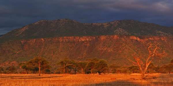
The Nguruman Escarpment is a faulted, rocky scarp that marks a sharp
transition between the semi-arid plains of the Rift Valley and the
higher, wetter Loita Plains to the west. Its steep, stepped faults
create a rugged, imposing wall, with the Southern Ewaso Ng’iro River
flowing southward along its base, fed by streams like the Entasopia
River that originate from the escarpment’s slopes. To the west lie the
Loita Hills, while below, the Rift Valley’s volcanic hills and plains
stretch toward Lake Magadi and Lake Natron, visible in the distance. The
escarpment’s elevation gradient—from 900 meters at the base to 2,300
meters at the crest—creates a diverse range of microclimates and
habitats.
The climate is semi-arid at the base, with annual
rainfall of about 400 mm, rising to 750 mm on the forested ridges and
peaks, where mist and dew are common. Temperatures are hot and dusty at
lower elevations (often exceeding 30°C), but cooler at higher altitudes,
especially at night. The region experiences two rainy seasons: the long
rains (March–June) and short rains (November–December), with the dry
season (June–October) being the most comfortable for outdoor activities.
The escarpment’s proximity to Lake Magadi, 45 kilometers away via dusty
tracks, ties it to the broader Rift Valley landscape.
Geology
The Nguruman Escarpment is a product of the tectonic activity that
formed the Great Rift Valley, part of the Gregory Rift, the eastern
branch of the East African Rift. This fault scarp was created by the
uplift and subsidence of tectonic plates, with the escarpment
representing the western edge of a block-faulted system. The valley
floor’s volcanic ash-rich soils and the escarpment’s rocky, stepped
faults reflect millions of years of geological processes, including lava
flows and erosion. The area’s fine, powdery ash, up to 50 cm deep in
places, poses challenges for driving, behaving like water and requiring
4WD vehicles. The escarpment’s geological significance is enhanced by
its proximity to active volcanic features, such as Ol Donyo Lengai,
visible from higher vantage points.
Ecology and Vegetation
The
Nguruman Escarpment’s dramatic elevation gradient supports a diverse
range of ecosystems, transitioning from arid lowlands to submontane
forests. Key vegetation zones include:
Valley Floor (900 m): Open
Acacia tortilis woodland dominates the semi-arid plains, with sparse
grasses and shrubs adapted to low rainfall.
Lower Slopes: Dense
Acacia–Commiphora bushland covers the foothills, providing habitat for
Somali–Masai biome species.
Mid-Slopes: Tarchonanthus thicket and
grasslands appear, supporting species like the threatened Prionops
poliolophus (grey-crested helmet-shrike).
Crest and Upper Slopes
(2,300 m): Submontane forest, with trees like Podocarpus falcatus, P.
latifolius, and Diospyros abyssinica, thrives in wetter conditions,
hosting Afrotropical Highlands biome species. Clear, fast-running
streams, fringed by riparian forests of Ficus spp. (figs), flow down the
escarpment, creating lush microhabitats.
Beyond the Crest: The Loita
Plains feature a mosaic of grassland, scrub, and forest, transitioning
toward the Maasai Mara.
The Entasopia River, originating from the
escarpment, sustains riverine forests and supports agriculture, making
the foothills cooler and greener than the surrounding plains. This
ecological diversity underpins the escarpment’s status as an Important
Bird Area (IBA) and a critical wildlife corridor.
The Nguruman Escarpment’s varied habitats support a rich array of
flora and fauna, with significant endemism and globally threatened
species. It is recognized by BirdLife International as the South
Nguruman IBA, notable for its avian diversity and large mammal
populations.
Birds
The escarpment hosts over 100 bird species,
including:
Restricted-Range Species: Cisticola hunteri (Hunter’s
cisticola) occurs at forest edges and scrub on the crest, while Apalis
alticola (brown-tailed apalis) is found only here in Kenya. Corvinella
melanoleucus (magenta-throated longclaw) is also rare, with few Kenyan
sites.
Threatened Species: The grey-crested helmet-shrike (Prionops
poliolophus) is likely present in Tarchonanthus thickets, though its
status is uncertain. Regionally threatened species include the bearded
vulture (Gypaetus barbatus, occasional visitor), crowned eagle
(Stephanoaetus coronatus, uncommon resident), red-chested flufftail
(Sarothrura affinis), and black-lored babbler (Campephaga quiscalina).
Biome-Specific Species: The lower slopes support 27 of Kenya’s 94
Somali–Masai biome species, such as the red-naped bushshrike (Parus
fringillinus), while the forest hosts 30 of 70 Afrotropical Highlands
biome species. The long-tailed widowbird (Euplectes jacksoni) nests in
grasslands above the crest.
Other Notable Species: The
chestnut-banded plover, unique to nearby Lake Magadi, underscores the
region’s avian significance.
Mammals
The escarpment and
adjacent Shompole and Olkiramatian Conservancies support substantial
populations of large mammals, including:
Critically Endangered:
Black rhinoceros (Diceros bicornis), though populations are small and
under threat.
Endangered: African wild dog (Lycaon pictus), with
occasional sightings.
Other Species: Lions, elephants, giraffes,
zebras, antelopes (e.g., gazelles), and hyenas are present, particularly
in conservancies. Elephants feed on tamarind trees in the Olkiramatian
Conservancy, while baboons and hyenas are common near campsites. Lions
are heard roaring at night, especially toward the Loita Hills and Maasai
Mara, but are rarely seen near Maasai villages due to community
presence.
Other Fauna
Invertebrates: The escarpment has been a
focus for tsetse fly (Glossinidae) control research by the International
Centre of Insect Physiology and Ecology (ICIPE), highlighting its
entomological significance.
Reptiles and Amphibians: While less
documented, the riparian forests and streams likely support diverse
herpetofauna, though specific species are not widely reported.
The Nguruman Escarpment lies within Maasailand, and the local
Maasai communities are integral to its cultural landscape. They
communally own much of the land through group ranches, maintaining
traditional pastoralist lifestyles with cattle, sheep, and goats.
Maasai boys herding livestock are a common sight, and their
villages, or bomas, reflect a deep connection to the land. The
Olkiramatian Conservancy, a community-led initiative, protects
wildlife and heritage, with tamarind groves serving as traditional
meeting places for warriors. The Maasai’s coexistence with wildlife,
such as camping safely among predators, underscores their ecological
knowledge.
The escarpment also supports a growing farming
community, enabled by the Ewaso Ng’iro and Entasopia Rivers, which
irrigate mango and pawpaw groves for Nairobi and export markets.
This agricultural activity, alongside pastoralism, creates a unique
blend of traditional and modern livelihoods. Visitors can engage
with Maasai culture through village visits, sampling local cuisine
like mbuzi choma (roasted goat), and learning about community
conservation efforts.
The Nguruman Escarpment contributes to the local economy through:
Agriculture: The fertile foothills, irrigated by the Entasopia and
Ewaso Ng’iro Rivers, support horticulture, with farmers supplying
mangoes, pawpaws, and other produce to urban and international markets.
Tourism: The escarpment is an emerging adventure destination, with
activities like hiking, camping, and wildlife viewing. Luxury lodges
like Lentorre, set on a spur off the escarpment, offer high-end
experiences with views of Mt. Shompole and Ol Donyo Lengai.
Community-based tourism, including cultural visits and guided treks,
supports local incomes.
Research: The Nguruman ICIPE Research Centre
conducts studies on tsetse fly control and trypanosomosis, contributing
to regional agricultural health.
Conservation: The Shompole and
Olkiramatian Conservancies generate revenue through eco-tourism and
partnerships with private operators, funding wildlife protection and
community development.
The Nguruman Escarpment faces several environmental and social
challenges:
Human-Wildlife Conflict: Lions, hyenas, and elephants
occasionally threaten livestock or crops, creating tensions with Maasai
herders and farmers. Conservancies mitigate this through patrols and
compensation programs.
Land Use Pressure: Agricultural expansion and
settlement encroach on wildlife habitats, fragmenting ecosystems.
Communal land ownership complicates conservation planning.
Climate
Change: Variable rainfall and increasing temperatures affect water
availability and vegetation, impacting both wildlife and agriculture.
Tourism Management: The escarpment’s remoteness and rough access roads
limit tourism growth, while unregulated visitor activities could strain
fragile ecosystems. Improved infrastructure and sustainable practices
are needed.
Conservation efforts are bolstered by the Shompole and
Olkiramatian Conservancies, which protect critical habitats and involve
Maasai communities in wildlife management. The South Nguruman IBA
designation highlights the need to preserve its avian diversity, with
ongoing surveys to document additional species. Community-led
initiatives, supported by organizations like Gamewatchers Safaris and
Porini Camps, promote low-impact tourism and wildlife protection.
The Nguruman Escarpment is a niche destination for adventurers,
nature enthusiasts, and cultural explorers. Key details and activities
include:
Access: The escarpment is a 160-km (3–4 hour) drive from
Nairobi via Magadi Road, passing the Ngong Hills, Lake Magadi, and dusty
Rift Valley plains. A 4WD vehicle with high clearance is essential due
to rough, ash-covered tracks. Public transport is limited to Ostrich
Services (one daily bus from Kiserian to Entasopia Market) or pickup
trucks/lorries. The route crosses Lake Magadi and requires careful
navigation.
Entry and Guides: No formal entry fees are reported, but
hiring a local guide (e.g., through Joseph Saningo, +254(0)715 648192)
is recommended for hikes and cultural visits. Guides ensure safety and
enhance experiences with local knowledge.
Activities:
Hiking: The
5–6-hour hike to Entasopia River Waterfalls is a highlight, ascending
from 750 meters to 2,000 meters through Maasai villages, forests, and
rocky terrain. The trail offers scenic views of the Rift Valley and Lake
Magadi. Longer treks across the Loita Hills to Maasai Mara are available
for experienced hikers.
Camping: Campsites like Cool Waters Camp, set
on riverbanks, offer basic tents and meals on request. Camping near the
Ewaso Ng’iro River provides a raw nature experience, with baboons and
hyenas audible at night. Secure food to avoid wildlife encounters.
Wildlife Viewing: Game drives in the Shompole and Olkiramatian
Conservancies offer sightings of giraffes, zebras, antelopes, and
occasionally lions or elephants. Night drives in Olkiramatian are
thrilling.
Cultural Experiences: Visiting Maasai bomas, sampling
mbuzi choma, and learning about farming and pastoralism provide cultural
immersion. The Olkiramatian Conservancy offers insights into community
conservation.
Photography and Stargazing: The escarpment’s dramatic
vistas, from Lake Magadi viewpoints to starry nights, are ideal for
photography. Clear skies make astrophotography rewarding, though cloud
cover can interfere.
Swimming and Relaxation: Some visitors swim in
the Ewaso Ng’iro River or relax at natural springs near Lentorre Lodge.
The Lake Magadi Sports Club, en route, offers a pool and meals.
Accommodation: Options include the Nguruman ICIPE Research Centre (basic
lodging with showers and meals), Cool Waters Camp (tents by the river),
and Lentorre Luxurious Lodge (high-end with views of Mt. Shompole).
Magadi town’s Sports Club is a budget-friendly stopover.
Best Time to
Visit: The dry season (June–October) is ideal for hiking, camping, and
wildlife viewing, with cooler temperatures at higher elevations. Wet
seasons (March–June, November–December) make roads muddy but enhance
greenery.
Safety and Tips: Bring ample water, sunscreen, and sturdy
shoes for hiking. Secure food to deter baboons. Be prepared for intense
heat and dust at lower elevations. A 4WD vehicle and local guide are
essential for navigation and safety.
The Nguruman Escarpment is a hidden gem, offering a stark contrast to
Kenya’s more famous destinations like Maasai Mara or Amboseli. Its
rugged beauty, from ash-covered plains to forested ridges, evokes a
sense of untouched wilderness. The escarpment’s ecological diversity,
supporting rare birds and mammals, makes it a haven for naturalists,
while its Maasai cultural heritage adds depth for travelers seeking
authentic experiences. As one blogger described it, the escarpment is a
“dusty, humid beauty,” with viewpoints overlooking Lake Magadi that
“take your breath away.” Another visitor praised the “soothing,
relaxing” drive and the chance to sample “super delicious” mbuzi choma.
Unlike crowded parks, Nguruman offers solitude and adventure, with
hikes to waterfalls, starry nights by the Ewaso Ng’iro, and glimpses of
wildlife in community-run conservancies. Its proximity to Lake Magadi
and Lake Natron makes it a gateway to the southern Rift Valley’s
wonders, yet its remoteness preserves an unspoiled character. The
escarpment’s challenges—dusty roads, basic facilities, and intense
heat—are part of its allure, rewarding those who venture off the beaten
path. Sustainable tourism, supported by Maasai-led conservancies and
responsible operators like Gamewatchers Safaris, ensures that Nguruman
remains a model for balancing conservation, culture, and adventure.
In summary, the Nguruman Escarpment is a multifaceted
destination—geologically striking, ecologically rich, and culturally
vibrant. It invites explorers to discover its waterfalls, wildlife, and
Maasai heritage, leaving them with memories of a raw, unfiltered slice
of Kenya’s Rift Valley.