Location: Map
Area: 155 sq km
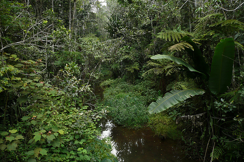
The Perinet Rainforest, also known as the Analamazaotra Special Reserve (ASR) or Périnet Special Reserve, is a key component of the larger Andasibe-Mantadia National Park in eastern Madagascar. Located approximately 150 km east of the capital city, Antananarivo, in the Alaotra-Mangoro Region, the park spans 155 square kilometers of primary rainforest at elevations between 800 and 1,260 meters. It features a humid climate with an average annual rainfall of 1,700 mm spread over 210 days. The area is accessible via a 3-hour drive on the paved Route Nationale 2 (RN 2), with the nearest towns being Moramanga and Andasibe (formerly Perinet). The Perinet section is particularly visitor-friendly, situated a short walk from the main road, while the Mantadia part requires special transport. The park's coordinates are around 18°49′36″S 48°26′52″E, making it one of Madagascar's most accessible protected areas for ecotourism.
The Perinet Rainforest refers to the lush, mid-altitude tropical
rainforest within Andasibe-Mantadia National Park in eastern Madagascar,
approximately 140 kilometers east of the capital Antananarivo in the
Alaotra-Mangoro Region. This protected area, covering about 155 square
kilometers, encompasses primary growth forest and is divided into two
main sections: the Analamazaotra Special Reserve (also called Périnet or
Andasibe Reserve) and Mantadia National Park. The name "Perinet"
originates from the French colonial era, named after engineer Henri
Périnet who oversaw the construction of a nearby train station in the
early 1900s, while "Andasibe" derives from the Malagasy term meaning "at
the big camp," reflecting its history as a logging hub. The rainforest
is renowned for its exceptional biodiversity, including 11 species of
lemurs such as the iconic indri (Madagascar's largest lemur), over 100
bird species, numerous reptiles like the panther chameleon, and unique
insects. It represents a fragment of Madagascar's eastern rainforests,
which have faced extensive deforestation but remain critical for global
conservation.
Geological and Ecological Origins
Madagascar's
eastern rainforests, including those in Andasibe, trace their origins to
the island's unique geological history. Madagascar separated from the
supercontinent Gondwana around 160-130 million years ago when it broke
away from Africa, and later detached from India approximately 88 million
years ago. This long isolation fostered extraordinary endemism, with
over 90% of the island's species found nowhere else on Earth. The
eastern region developed into humid tropical rainforests due to
prevailing trade winds that bring heavy rainfall (up to 3,500 mm
annually) from the Indian Ocean, creating a steep precipitation gradient
from east to west. Ecologically, these forests evolved as biodiversity
hotspots, with Andasibe's mid-altitude (800-1,200 meters) ecosystem
featuring dense canopies of endemic trees like rosewood and ebony,
epiphytes, ferns, and orchids. Fossil evidence and phylogenetic studies
indicate that many lineages, such as lemurs and tenrecs, arrived via
rafting from Africa around 50-60 million years ago, undergoing adaptive
radiation in the absence of large predators or competitors. The area's
freshwater ecosystems, including rivers and lakes, support unique fauna
like endemic fish and crustaceans, contributing to ecosystem services
such as water purification and flood control. However, climate
fluctuations over millennia, including drier periods, have shaped forest
extents, with current configurations dating back to the Holocene.
Pre-Colonial Human History
Human presence in Madagascar began
around 2,000-1,500 years ago with the arrival of Austronesian seafarers
from Southeast Asia, followed by Bantu migrants from Africa, leading to
the diverse Malagasy culture. In the eastern rainforests, indigenous
groups practiced subsistence agriculture, hunting, and gathering, with
minimal large-scale impact on the forests due to low population
densities. By the 19th century, the Merina Kingdom, under King Radama I
(r. 1810-1828), expanded eastward from the central highlands toward the
coast. This led to the establishment of small settlements like
Analamazaotra, a hamlet near a river and forest in the Andasibe area,
which served as a military post and lodging stop on the unpaved trail
connecting Antananarivo to coastal ports such as Toamasina (Tamatave).
Travel was arduous, often on foot or via palanquins for the elite, with
goods transported by zebu caravans. Local Betsimisaraka and other ethnic
groups interacted with the forests sustainably, revering species like
the indri as sacred ancestors in folklore, which may have afforded some
natural protection.
Colonial Period (1896-1960)
French
colonization in 1896 transformed the region. To facilitate trade and
resource extraction, the French upgraded the trail into a road and
constructed the Antananarivo-Toamasina railway in the early 1900s. A
train station was built near Analamazaotra and named Périnet after the
supervising engineer. Logging camps sprang up along the line to clear
land for tracks, provide timber for sleepers, and supply wood fuel for
steam engines, with the largest camp near the station dubbed Andasibe.
This attracted migrant workers from across Madagascar, turning the area
into a burgeoning village. Forests also yielded rubber from lianas.
Resource depletion prompted the French to establish the Station
Forestière Analamazaotra in 1909 as an experimental forestry site,
introducing exotic species like eucalyptus and pine in the 1910s for
reforestation. By the late 1930s, Andasibe became a popular lunch stop
for trains, with the Buffet de la Gare built. In the 1940s, graphite
mining by companies like Louys and Izouard further boosted the economy,
employing locals in forestry and extraction. These activities caused
significant deforestation, fragmenting habitats and introducing invasive
species.
Post-Independence and Establishment as a Protected Area
Following Madagascar's independence in 1960, the village officially
adopted the Malagasy name Andasibe, and the forestry station came under
the Département des Eaux et Forêts. Logging continued but declined, with
the last major sawmill, Complexe Industriel de Bois d’Andasibe
(C.I.B.A.), closing and leaving ruins. In 1970, recognizing the indri's
endangered status, the eastern part of the Analamazaotra Forest Station
was designated as a special reserve to protect this flagship species,
marking the beginning of formal conservation. Local communities,
previously reliant on forest resources for hunting and fishing,
transitioned to guiding tourists. In 1989, Mantadia National Park was
established, incorporating the Analamazaotra Reserve and adjacent
forests like Maromizaha Classified Forest, though logging and farming
isolated some areas. Management shifted to Madagascar National Parks. In
2002, the western half of the original forest station was transferred to
the local NGO Association Mitsinjo for community-based conservation.
Tourism boomed by the 2000s, becoming the primary economic driver for
the commune's 12,000 residents.
Conservation Efforts and Modern
Developments
Conservation intensified with the Analamazaotra
Re-introduction/Translocation (ART) project in 2006, a collaboration
between the Madagascar Biodiversity Partnership, Omaha's Henry Doorly
Zoo & Aquarium, Madagascar National Parks, and Eaux et Forêts. This
initiative relocated endangered lemurs like diademed sifakas and
black-and-white ruffed lemurs from threatened habitats into the reserve,
with 34 individuals introduced by 2014, leading to successful breeding
and two generations of offspring. Monitoring via radio collars and
genetic studies supported the project, which also engaged locals through
education and employment. In 2007, the park was nominated for UNESCO's
Rainforests of the Atsinanana World Heritage Site but not included.
Biological research has been extensive, with studies since 1989
identifying 229 new taxa in the region, underscoring its scientific
value. In 2025, UNESCO designated it a biosphere reserve, promoting
sustainable development amid ongoing threats. Efforts balance tourism
with resource protection, including reforestation and alternatives to
slash-and-burn agriculture.
Threats and Cultural Significance
Despite protections, the rainforest faces severe threats from
deforestation, with only about 10% of Madagascar's original forests
remaining due to logging, charcoal production, gold panning, and
conversion to eucalyptus/pine plantations or rice fields. High
population growth and poverty exacerbate these issues, leading to
habitat fragmentation and biodiversity loss. Culturally, the area holds
significance for Malagasy communities, with the indri embodying
ancestral spirits in legends. Today, Andasibe-Mantadia exemplifies
community-driven conservation, supporting livelihoods through ecotourism
while preserving a vital remnant of Madagascar's ancient rainforests.
Andasibe-Mantadia, including the Perinet Rainforest, is a
biodiversity hotspot characterized by dense primary montane rainforest.
Madagascar's isolation for over 160 million years has led to exceptional
endemism, with over 80% of species unique to the island. The park hosts
a rich array of flora, including orchids, ferns, and endemic trees,
though much of the surrounding habitat has been replaced by non-native
eucalyptus and pine plantations.
Fauna is particularly diverse, with
11 lemur species as highlights. The Perinet section is renowned for its
population of the indri (Indri indri), Madagascar's largest lemur, known
for its haunting, whale-like calls that echo through the forest. Other
lemurs include the diademed sifaka, black-and-white ruffed lemur, common
brown lemur, grey bamboo lemur, eastern bamboo lemur, woolly lemur, and
red-bellied lemur. The park is also a haven for over 100 frog species,
earning it the title of the "world’s capital of frogs," along with
vibrant butterflies, birds (such as the Madagascar blue pigeon and
ground rollers), and reptiles like the Parson’s chameleon—the largest
chameleon species. Nocturnal species include the insectivorous tenrec,
resembling a hedgehog. Overall, the park supports many rare and
endangered endemic species, contributing to Madagascar's status as a
megadiverse country with ecosystems ranging from rainforests to
mangroves.
Madagascar has lost over 40% of its forest cover in the last 60
years, with less than 15% remaining natural forest. In
Andasibe-Mantadia, primary threats include habitat loss from logging,
slash-and-burn agriculture (tavy), and population growth, exacerbating
poverty and resource extraction. Conservation initiatives focus on
balancing resource use with protection. Nearby reserves promote
sustainable alternatives to deforestation.
A key project is the
Analamazaotra Re-introduction/Translocation (ART) program, launched in
2006 by the Madagascar Biodiversity Partnership, Omaha's Henry Doorly
Zoo & Aquarium, and local authorities. Following IUCN guidelines, it
relocates endangered lemurs like diademed sifaka and black-and-white
ruffed lemurs from threatened areas to the safer Perinet Reserve. By
2014, 26 sifakas and 8 ruffed lemurs were successfully translocated,
with monitoring via radio collars and health assessments. The project
has seen multiple generations of offspring and includes community
education and employment for local guides. Broader efforts by
organizations like WWF and Rainforest Trust address biodiversity threats
across Madagascar, emphasizing the island's unique wildlife, where over
90% is endemic.
The park offers guided hikes lasting 1 to 6 hours in both the Perinet and Mantadia sections, with a local guide mandatory for entry. Activities emphasize wildlife viewing, particularly lemur spotting in the Perinet area, where indris are commonly observed. Night hikes reveal nocturnal creatures like tenrecs and frogs. Visitors can also explore nearby Lemur Island, a sanctuary for orphaned lemurs (brown, bamboo, and ruffed varieties) that are habituated to humans, allowing close interactions and photography. Easy forest walks introduce the eastern rainforest's flora and fauna, with multiple days ideal for comprehensive exploration. The park's accessibility makes it a staple on itineraries like those from Wilderness Travel, focusing on Madagascar's off-the-beaten-path experiences.