Location: Melaky Region Map
Area: 667 km²
Closest cities: Antsalova, Morondava
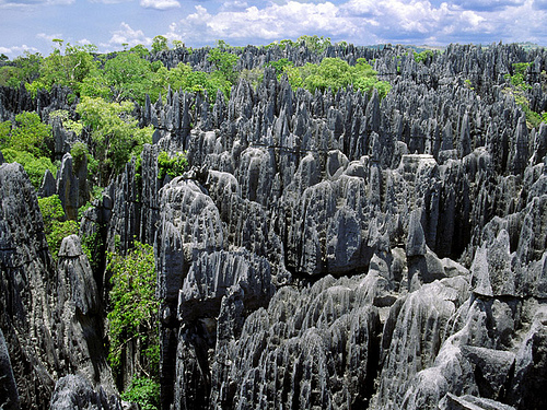
The Tsingy de Bemaraha, located in the Melaky region of western Madagascar, is a UNESCO World Heritage Site renowned for its extraordinary karstic landscapes, unique biodiversity, and cultural significance. Spanning approximately 157,500 hectares, it comprises the Tsingy de Bemaraha National Park (southern part, 66,600 hectares) and the Strict Nature Reserve (northern part, 85,300 hectares). The name "tsingy," derived from the Malagasy word meaning "where one cannot walk barefoot," aptly describes the razor-sharp limestone pinnacles that dominate the region, creating a surreal "forest of stone."
The Tsingy de Bemaraha is a geological marvel formed
over millions of years from Middle Jurassic (approximately 200 million
years ago) limestone deposits of marine origin, primarily fossilized
corals. Erosion by acidic rainwater and groundwater has sculpted a karst
landscape characterized by:
Limestone Pinnacles: Sharp,
needle-like formations, some reaching 100 meters high, create a
labyrinthine "stone forest." These pinnacles result from the dissolution
of calcium carbonate, forming vertical and horizontal crevasses, grikes,
and caves.
Canyons and Gorges: The Manambolo River, which crosses the
park, has carved a spectacular 300-meter-deep canyon, adding to the
dramatic topography.
Caves and Underground Rivers: A complex karst
hydrology includes underground waterways and caverns, some containing
sacred tombs of the Vazimba people.
Plateaus: The 250-km-long
Bemaraha Plateau, with elevations from 100 meters in the west to 600
meters in the east, forms the backbone of the landscape.
The
interplay of forest green vegetation against the metallic gray limestone
creates a visually striking effect, described as a "grandiose,
spectacular natural landscape" of universal beauty. Posts on X liken it
to a "labyrinth of limestone" or "Forest of Knives," emphasizing its
otherworldly appearance.
The Tsingy’s vegetation is classified as western dry
forest, one of Madagascar’s most threatened biomes, with over 650 plant
species, 85% of which are endemic. Key features include:
Dry
Deciduous Forest: Dominated by trees like Dalbergia (rosewood),
Commiphora, and Hildegardia, which shed leaves in the dry season (May to
November).
Xerophytic Scrub: Succulents, including bottle trees,
aloes, and Pachypodium, thrive on exposed limestone.
Sub-humid
Forest: Moister conditions in canyons support dense forests with orchids
and baobabs.
Savannah and Mangroves: Eastern lowlands and areas near
the Manambolo River host grassy savannahs and mangrove swamps.
The
isolation of the tsingy formations creates microhabitats, fostering high
endemism. For example, dolines (sinkholes) act as refuges for green
vegetation in the arid west.
Tsingy de Bemaraha is a biodiversity hotspot, with 85%
of its fauna endemic to Madagascar and 47% locally endemic to the
region. Its impenetrable terrain has created "refuges within a refuge,"
isolating species in small pockets, sometimes as small as a single
limestone spike.
Mammals: At least 42 mammal species, 35 endemic
to Madagascar.
Lemurs: 11 species, including the endangered Van der
Decken’s sifaka (Propithecus deckenii) and the locally endemic Bemaraha
woolly lemur (Avahi cleesei). Other species include red-fronted brown
lemurs, mouse lemurs, and bamboo lemurs.
Small Mammals: Locally
endemic species like the Tsingy tuft-tailed rat (Eliurus antsingy),
Grandidier’s shrew tenrec (Microgale grandidieri), and lowland red
forest rat (Nesomys lambertoni).
Carnivores: Two species from the
endemic Eupleridae family, including the fossa, Madagascar’s largest
predator.
Bats: 18 species inhabit caves and rock formations.
Birds: 96 species, 39 endemic to Madagascar. Notable species include the
critically endangered Madagascan fish eagle, the vulnerable Malagasy
harrier, and the endemic Coquerel’s coua with its striking blue eye
patches. The recently described rail Mentocrex beankaensis is known only
from the Bemaraha massif.
Reptiles and Amphibians: 63 reptile species
(58 endemic to Madagascar, 17 to Bemaraha) and 19 amphibian species, the
highest diversity in Madagascar’s dry regions.
Reptiles: The
critically endangered Madagascar big-headed turtle (Erymnochelys
madagascariensis), the locally endemic Antsingy leaf chameleon
(Brookesia perarmata), and vulnerable species like the big-headed gecko
and Nicosia’s chameleon.
Amphibians: High endemism, with species
adapted to the karst environment.
Invertebrates: New species are
frequently discovered, including unique spiders and insects adapted to
the harsh terrain.
The park’s isolation has driven speciation, with
many species awaiting formal description.
The Tsingy de Bemaraha holds deep cultural importance
for the Sakalava people, who inhabit the region, and the Vazimba,
considered Madagascar’s earliest inhabitants.
Sacred Sites: The
Manambolo River and its caves contain Vazimba graves, deemed fady
(taboo) and revered as spiritual sites.
Sakalava Traditions: The
Sakalava, primarily agriculturalists, view the landscape as sacred and
integrate conservation with cultural practices.
Historical Context:
Evidence suggests human settlements in the area date back 2,500 years,
linked to Austronesian migrations from Indonesia.
Designated a UNESCO World Heritage Site in
1990, the Tsingy de Bemaraha benefits from strong natural protection due
to its impenetrable terrain. Managed by Madagascar National Parks, the
site is part of the Andrefana Dry Forests serial property, expanded in
2023 to include additional protected areas.
Conservation
Strengths:
The karst landscape limits human encroachment, preserving
core areas.
Community engagement and ecotourism revenue support
conservation, with entrance fees partly shared with local communities.
Recent discoveries of new species underscore its global ecological
value.
Threats:
Localized Pressures: Subsistence hunting,
selective logging, livestock grazing, and pasture fires occur at forest
edges, though they pose little threat to the core.
Agricultural
Encroachment: Draining of peripheral lakes and marshes for rice
cultivation affects water flow.
Reptile Trade: Two reptile species
are traded locally, requiring monitoring.
Climate Change: Potential
shifts in rainfall and temperature could impact water-dependent species.
Access Challenges: Poor road infrastructure (e.g., a 9-hour drive from
Morondava on rough tracks) limits tourism but also complicates
management.
The IUCN Conservation Outlook (2020) rates the site’s
prospects as "good," with threats localized and manageable.
Accessible only from mid-April to mid-November due
to the rainy season, the park is best visited from June to November when
the Grand Tsingy is open. Located 180-250 km north of Morondava,
reaching Bekopaka (the park’s entry point) requires a 4x4 vehicle, two
ferry crossings, and a 14-hour drive from Antananarivo or 6-9 hours from
Morondava.
Activities:
Hiking and Via Ferrata: The park offers
circuits ranging from 1-7 hours:
Petit Tsingy: Easier trails like the
Andadoany Circuit (1-2 hours) offer panoramic views.
Grand Tsingy:
Challenging routes like the Andamozavaky Circuit (4-5 hours) involve
suspension bridges, ladders, and tunnels, requiring harnesses.
Ranotsara Circuit: A 6-7-hour advanced trek with deeper caves.
Anjohimanintsy Trail: A two-day camping trek through limestone
cathedrals and caverns.
Canoeing: The Manambolo Gorge half-day canoe
tour explores caves and sacred tombs.
Wildlife Watching: Spotting
lemurs, chameleons, and birds is a highlight, with guides pointing out
species like Decken’s sifaka crossing the tsingy.
Caving: Guided cave
walks reveal bats and geological formations.
Infrastructure:
Guides: Mandatory certified guides ensure safety and provide ecological
insights.
Accommodation: Options include:
Campsites within the
park (e.g., Camp Croco) with tent rentals.
Lodges in Bekopaka, like
Olympe du Bemaraha (bungalows with pools) or Tsingy Lodge (modest,
locally built).
Fees: Entrance fees (~55,000 MGA, ~$12) and tour fees
apply, payable at the Bekopaka park office or Antananarivo tourist
office.
Challenges: Trails are strenuous, requiring good fitness and
caution due to sharp rocks. Visitors report the landscape as "stunningly
sharp," with falls potentially dangerous. The remote location and rough
roads make planning essential, though tours like Jean Be Tours or
Madagascar Tour Guide simplify logistics.
The Tsingy de Bemaraha is a "living laboratory of evolution," with its isolation fostering unique species and ongoing discoveries. Its geological significance, dating back to the Jurassic, has been studied for 50 years, with research on caves, karst hydrology, and fossils. National Geographic and X posts highlight its formation from carbonic acid erosion, creating cavities over millennia. Culturally, it bridges Malagasy heritage with conservation, as local communities value its sacred sites and benefit from ecotourism.