Location: Arusha Region Map
Area: 137 km²
Arusha National Park, located in northern Tanzania near the city of Arusha, is a compact yet remarkably diverse 137-square-kilometer (53-square-mile) protected area established in 1960. Nestled between the peaks of Mount Meru and Mount Kilimanjaro, the park is often overshadowed by larger Tanzanian parks like Serengeti or Ngorongoro but offers a unique blend of lush forests, volcanic landscapes, wetlands, and rich wildlife. Its proximity to Arusha city (25 km) and Kilimanjaro International Airport (35 km) makes it an accessible gem for safaris, hiking, and cultural experiences.
Arusha National Park lies at coordinates approximately 3.25°S,
36.85°E, in Tanzania’s Arusha Region. It spans elevations from 1,400 to
4,566 meters (the summit of Mount Meru), creating a range of habitats
within a small area. The park is divided into three distinct zones:
Mount Meru: The park’s centerpiece, a dormant stratovolcano rising
to 4,566 meters, is Tanzania’s second-highest peak. Its eastern slopes
and crater dominate the western half of the park.
Ngurdoto Crater: A
3-km-wide volcanic caldera in the southeast, often called “Little
Ngorongoro,” with a swampy floor and forested rim, inaccessible to
vehicles but viewable from lookouts.
Momella Lakes: A series of seven
alkaline lakes in the northeast, fed by underground streams, surrounded
by grasslands and acacia woodlands.
The park’s climate is
tropical with montane influences:
Temperature: Ranges from 15–25°C at
lower elevations to near-freezing at Meru’s summit. Daytime temperatures
average 20–25°C, with cooler nights.
Rainfall: Annual precipitation
varies from 800 mm in lowlands to 2,000 mm on Meru’s slopes. The wet
season (March–May) brings heavy rains, while short rains occur in
November–December. The dry season (June–October) is ideal for visiting.
Humidity: High in forested areas and around lakes, especially during
rainy seasons.
Arusha National Park’s geology is shaped by volcanic activity:
Mount Meru: Formed 1.5 million years ago, Meru is a stratovolcano with a
collapsed eastern caldera from a massive eruption 8,000 years ago,
scattering ash as far as Kilimanjaro. Its slopes are composed of lava
flows, pyroclastic rocks, and ash deposits. The 1910 eruption was the
last significant activity, though minor seismic events occur.
Ngurdoto Crater: A smaller caldera formed by volcanic collapse, its
steep walls (up to 400 meters) and swampy floor result from ancient
eruptions and sediment accumulation.
Momella Lakes: These shallow,
alkaline lakes occupy depressions from volcanic activity, with high soda
content due to mineral-rich groundwater.
The park’s soils are
fertile, supporting dense forests on Meru’s slopes and grasslands in
lower areas. Basalt and tuff dominate the bedrock, with loamy soils in
wetlands.
Arusha National Park’s small size belies its ecological diversity,
hosting montane forests, savannas, wetlands, and alpine zones.
Flora
The park’s vegetation varies by elevation:
Montane Forest:
Covers Meru’s lower slopes (1,500–2,500 m), with dense stands of
Podocarpus (yellowwood), Juniperus (cedar), and Hagenia abyssinica.
Orchids, ferns, and epiphytes thrive in humid areas, with strangler figs
creating dramatic tree formations.
Acacia Woodlands: Surround Momella
Lakes and Ngurdoto Crater, dominated by Acacia tortilis and Acacia
xanthophloea (fever trees), mixed with grasses like Themeda triandra.
Grasslands: Open savanna areas support grazing herbivores, with Cynodon
grasses and wildflowers blooming in the wet season.
Alpine and Heath
Zones: Above 2,500 m on Meru, heather (Erica arborea), tussock grasses,
and giant lobelias (Lobelia deckenii) dominate, transitioning to barren
volcanic rock near the summit.
Wetlands: Ngurdoto’s crater floor and
lake margins feature reeds (Phragmites), sedges, and water lilies,
supporting aquatic ecosystems.
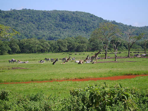
Fauna
The park’s wildlife,
while less dense than Serengeti, is diverse and accessible:
Mammals: Notable species include giraffes (Giraffa camelopardalis), Cape
buffalo (Syncerus caffer), and blue monkeys (Cercopithecus mitis).
Colobus monkeys (Colobus guereza), with striking black-and-white fur,
are common in forests. Smaller mammals like bushbuck (Tragelaphus
scriptus), dik-dik (Madoqua kirkii), and warthogs (Phacochoerus
africanus) roam savannas. Leopards (Panthera pardus) and hyenas (Crocuta
crocuta) are present but elusive. Elephants and lions are absent, making
the park safer for walking safaris.
Birds: Over 400 species,
including flamingos (Phoenicopterus roseus) on Momella Lakes, African
fish eagles (Haliaeetus vocifer), and Narina trogons (Apaloderma narina)
in forests. Ngurdoto Crater attracts waterbirds like egrets and herons,
while Meru’s slopes host mountain buzzards (Buteo oreophilus).
Reptiles and Amphibians: Pythons (Python sebae), agama lizards (Agama
sinaita), and chameleons inhabit forests. Frogs, such as the Hyperolius
reed frog, thrive in wetlands.
Invertebrates: Butterflies like the
African monarch (Danaus chrysippus) and beetles are abundant, with
termite mounds dotting savannas.
The park’s lakes and wetlands are
critical for migratory birds, while Meru’s forests provide refuge for
primates and rare species.
Arusha National Park lies within the traditional lands of the Meru
and Maasai peoples:
Meru People: The WaMeru, Bantu-speaking
farmers, live around the park’s edges, cultivating bananas, coffee, and
maize. Mount Meru is sacred, believed to be a dwelling place of
ancestors. The park’s name reflects their cultural presence.
Maasai:
Semi-nomadic pastoralists graze cattle near the park, occasionally
entering buffer zones. Their colorful beadwork and traditions are
visible in nearby villages.
Colonial History: The area was part of
German East Africa until 1919, then British Tanganyika. The park was
initially a game reserve in the early 20th century, named Ngurdoto
Crater National Park in 1960, and renamed Arusha National Park in 1967
to reflect its broader scope and proximity to Arusha city.
Conservation Legacy: The park’s creation involved relocating some Meru
communities, leading to ongoing efforts to balance conservation with
local livelihoods. Eco-tourism now supports schools and clinics in
nearby villages.
Arusha National Park is a versatile destination, offering safaris,
hiking, canoeing, and cultural interactions, often as a day trip or
prelude to larger Tanzanian safaris.
Activities
Game Drives:
Guided 4x4 safaris explore the Momella Lakes, Ngurdoto Crater rim, and
Meru’s lower slopes. Morning drives (6–9 AM) maximize wildlife
sightings, with giraffes, buffalo, and monkeys commonly spotted. Night
drives are unavailable due to park regulations.
Walking Safaris:
Unique to Arusha (as larger predators like lions are absent), guided
walks (2–4 hours) allow close encounters with flora and fauna. Rangers
carry rifles for safety. Popular routes include the Maio Waterfall trail
and Ngurdoto Crater rim.
Canoeing: Momella Lakes offer 1–2-hour canoe
trips, ideal for birdwatching (flamingos, pelicans) and photographing
Meru’s reflection. Trips cost ~$50–75, booked through lodges or
operators.
Mount Meru Climbing:
Duration: 3–4 days round-trip
(2–3 days ascent, 1 day descent).
Difficulty: Strenuous, less crowded
than Kilimanjaro but technically demanding, with steep slopes and a
4,566-meter summit (Socialist Peak).
Route: The Momella Route starts
at 1,500 m, passing through forests, heath zones, and volcanic ash
cones. Key stops include Miriakamba Hut (2,514 m) and Saddle Hut (3,570
m). The final ascent involves a pre-dawn scramble along the crater rim.
Highlights: Views of Kilimanjaro (70 km away), the Ash Cone (a 3,600-m
mini-crater), and wildlife like colobus monkeys. The summit offers 360°
vistas of the Drakensberg and Rift Valley.
Cost: ~$800–1,200,
including guides, porters, permits, and huts. Book via Tanzania National
Parks (TANAPA) or operators like Altezza Travel.
Cultural Tours:
Visits to Meru or Maasai villages near Usa River or Ngare Nanyuki offer
insights into farming, herding, and traditional dances. Beadwork
workshops and market visits are available (~$20–50).
Photography: The
park’s landscapes—Meru’s silhouette, Ngurdoto’s green crater, and pink
flamingos on Momella Lakes—are photogenic. Golden hour (sunrise/sunset)
enhances colors.
Key Sites
Ngurdoto Crater: Viewpoints like
Meru Crater Lookout and Leitong Hill offer sweeping views of the
crater’s swampy floor, often with buffalo grazing.
Momella Lakes:
Seven lakes (Big and Small Momella, El Kekhotoito, Kusare, Rishateni,
Lekandiro, Tulusia) vary in color due to algae and minerals, creating a
serene setting for canoeing and birding.
Mount Meru: The climb
includes Fig Tree Arch (a natural bridge formed by a strangler fig),
Maio Waterfall, and the Ash Cone, with panoramic summit views.
Tululusia Waterfall: A 28-meter cascade on Meru’s slopes, reachable via
a 1–2-hour hike, ideal for picnics and swimming.
Access:
By Road: 25 km (30–40 minutes) from Arusha via the A104
and park gate at Ngongongare. From Kilimanjaro Airport, it’s 35 km (45
minutes). Most visitors use safari vehicles arranged by tour operators.
By Air: Kilimanjaro International Airport is the nearest hub, with
flights from Dar es Salaam, Nairobi, or Zanzibar. Transfers to the park
are easily arranged.
Entrance Fees: $59 USD (adults), $17.70
(children 5–15), valid for 24 hours (as of 2025, per TANAPA). Additional
fees apply for vehicles ($11.80–35.40), canoeing ($29.50), and walking
safaris ($23.60/ranger). Meru climbing permits cost ~$100/day, plus hut
fees.
Accommodations:
Inside the Park: Hatari Lodge (luxury,
~$300–600/night), Meru View Lodge (~$100–200/night), and TANAPA-run
Miriakamba and Saddle Huts for climbers (~$30/night).
Nearby: Arusha
offers hotels like Mount Meru Hotel (mid-range, ~$80–150) or Arusha
Coffee Lodge (luxury, ~$200–400). Usa River has budget guesthouses
(~$20–50).
Camping: Public campsites at Momella and Ngongongare
(~$35.40/night) have basic toilets and water. Private campsites at
lodges are pricier.
Facilities: The park has a visitor center at
Ngongongare Gate with maps and exhibits. Toilets are available at
campsites and lodges, but trails lack amenities. Bring water, snacks,
sunscreen, and binoculars.
Guides: Mandatory for walking safaris and
Meru climbs (included in fees). Game drives require licensed drivers,
typically provided by operators.
Best Time to Visit:
Dry
Season (June–October): Clear skies, less mud, and peak wildlife
visibility. Ideal for Meru climbing and safaris.
Wet Season
(March–May): Lush scenery, fewer crowds, and vibrant birdlife, but
trails are muddy, and climbing is riskier.
Short Rains
(November–December): Moderate conditions, good for budget travel, though
rain can disrupt plans. Early mornings offer cooler temperatures and
active wildlife.
Managed by Tanzania National Parks (TANAPA), Arusha National Park
faces several threats:
Human-Wildlife Conflict: Nearby Meru and
Maasai communities face crop damage from buffalo and monkeys, leading to
poaching or retaliation. TANAPA’s community programs, like beekeeping
and eco-tourism, aim to reduce conflict.
Deforestation: Historical
logging on Meru’s slopes reduced forest cover, though reforestation
efforts are ongoing. Illegal charcoal production persists outside park
boundaries.
Tourism Pressure: Overuse of trails, especially near
Momella Lakes, causes erosion. Canoeing and walking safaris are capped
to minimize disturbance.
Invasive Species: Non-native plants like
Lantana camara threaten grasslands. TANAPA conducts removal campaigns.
Climate Change: Altered rainfall patterns affect lake levels and forest
health, while glacial retreat on Meru’s summit (though minimal) mirrors
Kilimanjaro’s ice loss.
Conservation initiatives include ranger
patrols, community education, and tourism revenue sharing, which funds
schools and water projects. The park’s role in the Arusha Manifesto
(1961), Tanzania’s foundational conservation policy, underscores its
legacy.
Ecological Research: The park’s diverse habitats support studies on
montane forest dynamics, bird migration, and primate behavior. Colobus
monkey populations are monitored for conservation insights.
Geological Studies: Meru’s volcanic history informs research on East
African Rift volcanism, with ash layers providing paleoclimatic data.
Cultural Heritage: The WaMeru and Maasai contribute to Tanzania’s
cultural mosaic, with their traditions showcased in tourism. The park’s
proximity to Arusha, a hub for safari logistics and the East African
Community, enhances its regional importance.
Tourism Role: As a
gateway to Tanzania’s northern circuit, the park introduces visitors to
the country’s biodiversity and sets the stage for larger safaris.