Location: Kanungu District Map
Area: 331 km2 (128 mi2)
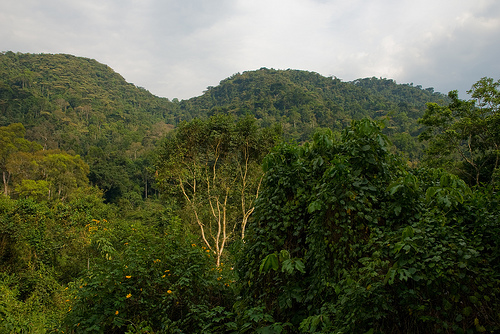
Bwindi Impenetrable National Park, located in southwestern Uganda, is a UNESCO World Heritage Site renowned for its biodiversity, rugged terrain, and as a sanctuary for roughly half of the world’s remaining mountain gorillas. Spanning approximately 321 square kilometers, the park is nestled within the Albertine Rift, a region known for its ecological richness. Its name, "Impenetrable," reflects the dense, tangled forests and steep, misty valleys that characterize its landscape, creating a challenging yet captivating environment for wildlife and visitors alike.
Bwindi lies along the border with the Democratic Republic of Congo, near the Virunga Volcanoes, at elevations ranging from 1,160 to 2,607 meters above sea level. The park’s topography is rugged, with steep hills, narrow valleys, and fast-flowing rivers. Its forests are a mix of lowland and montane ecosystems, transitioning from dense jungle at lower altitudes to misty, cloud-covered Afromontane forests higher up. The park’s high altitude and dense canopy create a cool, humid climate, with temperatures averaging 7–20°C (45–68°F). Rainfall is significant, ranging from 1,400 to 1,900 mm annually, with two wet seasons (March–May and September–November) and drier periods in June–August and December–February.
Bwindi is one of Africa’s most biologically diverse forests, hosting
over 120 mammal species, 350 bird species, 220 butterfly species, and
numerous reptiles, amphibians, and plants. Its flora includes over 1,000
flowering plant species, with 163 tree species and 104 fern species,
many of which are endemic to the Albertine Rift. The forest’s dense
undergrowth, vines, and epiphytes create a complex ecosystem supporting
a wide range of life.
Key Wildlife:
Mountain Gorillas: Bwindi
is home to approximately 400–500 mountain gorillas, nearly half of the
global population of about 1,000. These critically endangered primates
live in family groups led by a dominant silverback. Gorilla trekking, a
major draw for visitors, involves guided hikes to observe habituated
groups.
Other Mammals: The park hosts elephants (rarely seen),
chimpanzees, baboons, colobus monkeys, and smaller primates like
L’Hoest’s monkeys. Small antelopes (duikers), bushpigs, and elusive
predators like serval cats and African golden cats also inhabit the
forest.
Birds: Bwindi is a birder’s paradise, with 23 Albertine Rift
endemics among its 350 bird species. Notable species include the African
green broadbill, Shelley’s crimsonwing, and the handsome francolin. The
park’s dense forest and varied altitudes create diverse habitats for
these species.
Butterflies and Reptiles: With 220 butterfly species
and numerous reptiles (including chameleons and geckos), Bwindi’s
smaller fauna add to its ecological richness. Amphibians, such as the
endemic Bwindi frog, thrive in the park’s wet environment.
Bwindi’s mountain gorillas are its most famous residents, and their
conservation is central to the park’s mission. In the 1990s, gorilla
habituation programs began, allowing small groups of tourists to observe
these animals while minimizing disturbance. Today, 20 gorilla families
are habituated for trekking, with permits costing around $700–$800 USD
per person. Trekking is tightly regulated: groups are limited to eight
visitors, and time with gorillas is capped at one hour to reduce stress
on the animals. The challenging terrain and high altitude make treks
physically demanding, often lasting 2–7 hours.
Conservation
efforts have increased gorilla numbers, but threats remain, including
poaching, habitat encroachment, and disease transmission from humans
(gorillas share 98% of human DNA, making them susceptible to human
pathogens). The Uganda Wildlife Authority (UWA), alongside NGOs like the
International Gorilla Conservation Programme, enforces strict rules,
such as maintaining a 7-meter distance from gorillas and prohibiting
visits by sick individuals.
Bwindi is surrounded by human communities, including the Bakiga and
Bafumbira peoples, who historically relied on the forest for resources.
The Batwa, a marginalized indigenous group, were the forest’s original
inhabitants but were displaced when the park was established in 1991.
This displacement has led to ongoing efforts to integrate the Batwa into
conservation and tourism benefits, such as guiding and cultural tours,
though challenges like poverty and landlessness persist.
Community-based tourism initiatives, such as the Bwindi Community
Hospital and local handicraft markets, channel tourism revenue into
local development. Visitors can engage in cultural experiences, like
visiting Batwa villages or attending traditional dance performances,
fostering economic benefits and cultural exchange.
Beyond gorilla trekking, Bwindi offers diverse activities:
Birdwatching: Guided walks target endemic and rare species, with
hotspots like the Mubwindi Swamp.
Nature Walks: Trails like the
Munyaga River Trail and Rushura Hill offer insights into the forest’s
flora, waterfalls, and smaller wildlife.
Batwa Cultural Experiences:
Visitors can learn about Batwa traditions, including hunting techniques
and medicinal plant use.
Chimpanzee Trekking: Though less common than
gorilla trekking, habituated chimpanzee groups in the Rushaga sector are
available for tracking.
The park has four main sectors for gorilla
trekking—Buhoma, Ruhija, Rushaga, and Nkuringo—each with lodges ranging
from budget to luxury. Buhoma is the most developed, with amenities like
restaurants and Wi-Fi, while Nkuringo and Rushaga offer more remote,
rugged experiences.
Bwindi faces ongoing challenges, including human-wildlife conflict,
as communities near the park deal with crop-raiding by baboons and
elephants. Climate change poses a threat, potentially altering the
forest’s delicate ecosystem. Balancing tourism revenue with conservation
is critical, as over-tourism could stress gorilla populations or degrade
habitats.
Efforts to address these issues include community
revenue-sharing (10% of park fees go to local projects), anti-poaching
patrols, and reforestation initiatives. Research continues to monitor
gorilla health and forest biodiversity, ensuring Bwindi remains a
stronghold for conservation.
Access: Bwindi is accessible by road (8–10 hours from Kampala) or by
charter flights to airstrips like Kihihi or Kisoro. The park is about
1–2 hours from Rwanda’s border, making it combinable with visits to
Volcanoes National Park.
Permits: Gorilla trekking permits must be
booked months in advance through the UWA or tour operators due to
limited daily slots (around 160 permits across all sectors).
Best
Time to Visit: Dry seasons (June–August, December–February) offer easier
trekking conditions, though wet seasons provide lush scenery and fewer
crowds.
Health and Safety: Visitors need good physical fitness for
trekking. Vaccinations (e.g., yellow fever) and malaria prophylaxis are
recommended. Strict gorilla-visiting rules protect both animals and
humans.