Location: Manicaland province Map
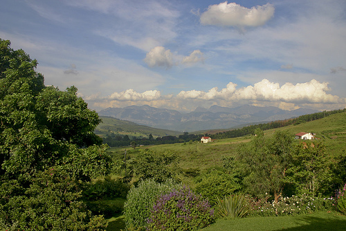
Chimanimani National Park is a protected biosphere in a
Manicaland province in Zimbabwe. It is one of most popular
destinations for hiking pristine African wilderness. Chimanimani
National Park is located in the Chimanimani district along border
between Zimbabwe and Mozambique. Chimanimani mountain massif are
famous for its magnificent picturesque views and spectacular canyons
and deep gorges. The tallest peak here is mount Binga on the
Mozambican border. It reaches an elevation of 2437 meters above sea
level.
Chimanimani National Park is a popular hiking
destinations among tourist who visit the area. Many of the places
inside the biosphere are impossible to access by vehicle so hiking
is the only option. However, keep in mind that during Independence
War of Zimbabwe guerilla forces frequented the area. They
established numerous camps in the Chimanimani mountains and left
several mine fields in the area. So if you decide to venture into
these lands on your own take a map and don't venture from
established paths and trails.
Hiking trails on Chimanimani
National Park begin at the Mutekeswane Base Camp situated 19 km from
Chimanimani village, last large settlement in the area. Trails range
in intensity and complexity. The easiest hike is Banana Grove Track
that can take 30- 50 minutes depending on a pace. It takes visitors
to the Skeleton Pass, a former trail used by the guerilla forces
that moved people and ammo between Zimbabwe and Mozambique border.
Bailey Folly trail on the other hand takes about three hours to
complete.
In addition to pristine nature Chimanimani
National Park is famous for rock art left by ancient humans that
once lived here. They left numerous paintings of humans, animals and
abstract shapes that were used during religious ceremonies.
The Ndau ethnic group has lived in the area around the Chimanimani
Mountains for centuries. In the early 19th century, people speaking
Nguni languages left what is now South Africa to settle in the Save
River valley. The Nguni leader Soshangane founded the Gaza Empire, which
subjugated the area from the Limpopo River to the Zambezi, including the
local Ndau population. In the late 19th century, the Gaza Empire came
into conflict with European colonial empires: the British expanding
north from South Africa and the Portuguese expanding inland from the
coast of Mozambique.
The Anglo-Portuguese Treaty of 1891 fixed
the border between the colonial possessions of the United Kingdom and
Portugal in South and East Africa, and divided the Chimanimani Mountains
between the British colony of Southern Rhodesia and the Portuguese
colony of Mozambique. Differing interpretations of the treaty language
by the UK and Portuguese governments revived the border dispute, with
Paul Honoré Vigliani, assistant to the King of Italy, arbitrating the
settlement of the border between the Zambezi and Save rivers. The
arbitration was completed on January 30, 1897, establishing the
international border that has stood to this day. The new boundary
divided the Ndau communities living on either side of it.
The
Government of Southern Rhodesia established the Chimanimani National
Park in 1949, with an original area of 82 km². Later, the park was
expanded to 155 km². In 1953, the Mozambican colonial government
unveiled the Maronga, Zomba, and Moribane forest reserves on the
southeastern slopes of the mountains. Both colonial governments also
expanded logging and farming during the 1940s and 1950s. The Southern
Rhodesia Forest Department and private companies created extensive
plantations of pine, acacia, and eucalyptus in the mountains and valleys
west of the National Park boundary. . The colonial government of
Mozambique established sawmills and logging concessions in the lower
elevation and dense forests southeast of the mountains.
Mozambique gained independence from Portugal in 1975, but suffered a
civil war from 1977 to 1992. Southern Rhodesia declared independence as
Rhodesia under an exclusively white minority government in 1965. The
Rhodesian Civil War, or Zimbabwean War of Independence, lasted from 1964
to 1979. During the war, guerrillas moving between Zimbabwe and their
camps in Mozambique frequently used mountain passes in the Chimanimani
area, and guerrillas laid landmines along local roads to disrupt the
local economy. The passes were heavily mined by Rhodesian government
forces to prevent guerrilla movements. In 1980 an agreement was reached
that gave the country's black majority full political participation, and
the country was renamed Zimbabwe. Decades later, landmines remain a
danger in the area, particularly after heavy rains.
In 2003, the
Mozambican government created the Chimanimani National Reserve, with an
area of 640.6 km² encompassing the high mountains on the Mozambican
side.
Much of the range is made up of quartzite ridges running from north
to south, with Mount Binga (2,436m) as the highest point. Other summits
include Mount Peza (2,152 m), Mount Dombe (2,188 m), and Mawenje or
Torres de Turret (2,362 m) in Zimbabwe, and Mount Nhamadimo (2,144 m) in
Mozambique. The mountains are drained by tributaries. of the Buzi River,
including the Rusitu (called Lucite in Mozambique) and the Mussapa.
The mountains are found in the Chimanimani district of Manicaland
province in Zimbabwe and in the Sussundenga district of Manica province
in Mozambique.
The mountains rise above the Mozambican plain, and
the eastern face intercepts the winds from the Indian Ocean, giving rise
to orographic precipitation. In the wettest zone there is hardly any
difference between the seasons. The western slopes, in Zimbabwe, are in
the rain shadow zone, and are generally drier. At the Chimanimani and
Chisengu weather stations in Zimbabwe, 1074 mm and 1406 mm were
recorded, respectively.
The summer rainy season runs from
November to the end of March or April. Above 1,500 meters, rain can fall
at any time of the year, and frequent fog and cloudy days during the dry
season reduce stress on plants.
The average temperatures of 22.oC
in the southeast drop to less than 18.oC in the highest areas. Frosts
occur above 1500 meters.
Above 1,000 meters, the landscape forms part of the Zimbabwe Eastern
Highlands ecosystem.
montane plant communities
Montane plant
communities (generally above 1000 meters in elevation) include
grasslands, shrublands (scrublands), forests, and lithophytic
vegetation. The Chimanimani montane plant communities belong to the
Afromontane region and share many species with other high altitude
montane regions scattered from South Africa to Ethiopia. 70 species of
montane plants are endemic to the Chimanimani mountains.
meadows
Grasslands are the most widespread vegetation, especially on flat and
undulating land. There are three main types depending on the type of
soil: quartzite, shale and wet or hydromorphic.
On quartzitic
soils, grasslands generally grow low, with tufted grasses. Common weeds
are Loudetia simplex, Sporobolus festivus, Panicum brazzavillense,
Elionurus muticus, Monocymbium ceresiiforme, Panicum ecklonii, Rhytachne
rottboellioides, and Trachypogon spicatus. Quartzite grasslands cover an
area of 50 to 100 km².
Shale grasslands grow on shale-derived
soils, which are generally red in color and deeper and richer in
nutrients than quartzite-derived soils. Shale grasslands grow taller and
denser, with Themeda triandra as the dominant grass, along with the
grasses Loudetia simplex, Tristachya hispida, Monocymbium ceresiiforme,
and the sedge Bulbostylis contexta. The bushes Protea caffra subsp.
gazensis, Indigofera cecilii and Morella chimanimaniana and the fern
Pteridium aquilinum are also typical. Shale grasslands cover an area of
about 150 km².
thickets
Shrubs grow on steeper slopes and
are of two main types, ericaceans and proteaceans.
Ericaceous
scrub is found on soils derived from quartite above 1,200 meters. It is
characterized by shrubs in the heather family Ericaceae, including Erica
hexandra, Philippia simii, Erica pleiotricha, Erica johnstonii, and
Erica lanceolifera. The ericaceous scrub includes many other species,
including many of the species endemic to the eastern highlands and the
Chimanimani Mountains.
The proteacean scrub is found on
shale-derived soils between 1,100 and 1,800 meters in elevation,
interspersed with shale grasslands. The dominant shrubs are from the
protea family (Proteaceae), including Protea caffra, [[Protea
welwitschii|P. welwitschii]], P. wentzeliana, and Leucospermum saxosum,
along with smaller shrubs, herbs, and grasses.
Other types of
scrub include the mixed sclerophyllous scrub, which contains a mixture
of ericaceous and proteaceous species, and the fern scrub, characterized
by the fern Pteridium aquilinum, along with shrubs and tall grasses. The
fern thicket is found on richer soils near forest patches.
miombo
forest
The mountains are home to three types of miombo forests. Trees
are generally 4 to 8 meters tall, with 20 to 60% canopy cover, with
grasses and ferns covering the ground.
Mzhenje forest (Uapaca
kirkiana) is found on east-facing slopes below 1,200 meters elevation,
typically on shale-derived soils. Mzhenge is accompanied by the trees
Brachystegia utilis, Pterocarpus angolensis, and Pericopsis angolensis
at lower elevations.
Msasa forest (Brachystegia spiciformis) is
also found on shale soils. Trees tend to grow low (2 to 4 meters tall)
and widely scattered at higher elevations. At lower elevations, the
trees grow closer together, and Uapaca kirkiana and Faurea saligna
accompany msasa.
The forest of Brachystegia tamarindoides subsp.
microphylla grows on quartzite outcrops and rocky slopes. The trees are
low and covered with Usnea lichen.
montane forest
Montane
forests are found in scattered patches, usually in sheltered areas with
year-round access to moisture. Small patches of 1 to 5 hectares are the
most common, with areas up to 30 km in some places. The largest copse
discovered by Timberlake et al. it is 240 hectares, on a west-facing
slope above the Nyahedzi River.
The trees form a closed canopy 10
to 15 meters high. Lianas and epiphytes are common in the canopy, and
understory plants are mainly ferns and mosses. Common trees include
Schefflera umbellifera, Ilex mitis, Macaranga mellifera, Maesa
lanceolata, Morella pilulifera, Podocarpus milanjianus, and Syzygium
cordatum, and Widdringtonia nodiflora in drier segments.
A type
of transitional forest can be found at the edges of stands and along
streams and gullies in grassland and scrubland areas, and includes a mix
of ericaceous woodland and shrub species, along with grasses and ferns.
They include large shrubs and small trees such as Philippia mannii,
Englerophytum magalismontanum, Rapanea melanophloeos, and Myrsine
africana. Larger stands of shrubs, similar to the paradise flower
Strelitzia caudata and the tree fern Cyathea capensis, grow in sheltered
spots along streams surrounded by more open vegetation.