Location: Map
Area: 2,500 sq km
Mana Pools National Park, located in northern Zimbabwe along the southern banks of the Zambezi River, is a UNESCO World Heritage Site renowned for its pristine wilderness, abundant wildlife, and unique ecological features. Covering approximately 2,196 square kilometers, the park lies in the Zambezi Valley, bordered by Zambia to the north and the rugged Zambezi Escarpment to the south. Its name, “Mana,” means “four” in the Shona language, referring to the four large permanent pools formed by the Zambezi River’s meanders, which are central to the park’s ecosystem. Mana Pools is celebrated for its raw beauty, exceptional biodiversity, and opportunities for immersive, low-impact safari experiences like walking safaris and canoeing. Below is an in-depth exploration of the park’s geography, biodiversity, cultural and historical context, tourism, and conservation efforts.
Mana Pools National Park occupies a dynamic floodplain
ecosystem shaped by the Zambezi River, one of Africa’s mightiest
waterways. The park’s landscape is a mosaic of riverine forests,
seasonal wetlands, and open savanna, creating a visually stunning and
ecologically rich environment.
Zambezi River and Floodplains: The
Zambezi River forms the park’s northern boundary, separating Zimbabwe
from Zambia’s Lower Zambezi National Park. During the rainy season
(November to April), the river overflows, flooding the surrounding
plains and replenishing the park’s four main pools—Long Pool, Chine
Pool, Green Pool, and Main Pool. These oxbow lakes, remnants of ancient
river channels, remain water-filled year-round, serving as vital water
sources during the dry season (May to October).
Vegetation Zones: The
park features diverse habitats:
Riverine Forests: Dense stands of
mahogany, ebony, and winterthorn (Faidherbia albida) line the
riverbanks, providing shade and food for herbivores.
Floodplain
Grasslands: Seasonal floodplains support lush grasses that attract
grazing animals like impala and buffalo.
Mopane Woodlands: Inland
areas are dominated by mopane trees (Colophospermum mopane), adapted to
the region’s hot, dry climate.
Jesse Bush: Dense thickets of shrubs
offer cover for smaller mammals and birds.
Zambezi Escarpment: The
southern boundary of the park rises into the rugged hills of the
escarpment, adding dramatic topography and serving as a transition to
the drier interior of Zimbabwe. These hills host unique flora and
provide vantage points for breathtaking views of the valley.
Geological Features: The park’s soils are primarily alluvial, deposited
by the Zambezi’s floods, creating fertile ground for vegetation. The
shifting river channels and seasonal flooding make the landscape
dynamic, with new pools and islands forming over time.
The climate is
hot and humid, with temperatures often exceeding 35°C in the dry season.
Rainfall averages 700–1,000 mm annually, concentrated in the wet season,
which transforms the park into a lush, green oasis.
Mana Pools is a biodiversity hotspot, supporting a remarkable array of wildlife and plant species. Its position along the Zambezi River and varied habitats create ideal conditions for both terrestrial and aquatic ecosystems.
The park is home to over 70 mammal species, many of
which are iconic African megafauna. Its floodplains and pools attract
large concentrations of animals, especially during the dry season when
water is scarce inland.
Large Mammals:
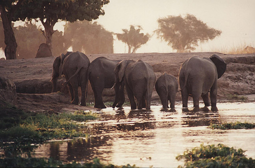
Elephants: Mana Pools
is famous for its large elephant populations, with herds often seen
wading in the Zambezi or feeding on winterthorn pods. Some elephants are
known for standing on their hind legs to reach high branches, a behavior
unique to the region.
Buffalo: Massive herds of Cape buffalo,
sometimes numbering in the hundreds, roam the floodplains, drawing
predators.
Predators: The park supports healthy populations of lions,
leopards, spotted hyenas, and African wild dogs, the latter being a
conservation priority due to their endangered status. Cheetahs are less
common but occasionally sighted in open areas.
Hippos and Crocodiles:
The Zambezi River and pools teem with hippos and Nile crocodiles, which
are often seen basking or hunting along the water’s edge.
Antelopes:
Common species include impala, waterbuck, kudu, eland, and the shy
nyala, which thrives in the riverine forests.
Rare and Unique
Species: Mana Pools is one of the few places in Zimbabwe where the sable
antelope and roan antelope can be spotted. The park also hosts small
populations of black rhinos, though poaching has severely reduced their
numbers.
Primates: Vervet monkeys and chacma baboons are abundant,
often seen foraging near camps or along the river.
With over 380 bird species recorded, Mana Pools is a
birdwatcher’s paradise. The park’s wetlands, forests, and savannas
attract a mix of resident and migratory birds.
Notable Species:
Highlights include the African fish eagle, whose iconic call echoes
along the Zambezi; the vibrant lilac-breasted roller; and the southern
carmine bee-eater, which nests in riverbank colonies during the dry
season. Waterbirds like herons, egrets, and kingfishers are abundant
near the pools.
Raptors and Vultures: The park supports martial
eagles, bateleurs, and several vulture species, including the critically
endangered white-backed vulture.
Seasonal Visitors: Migratory birds,
such as the European bee-eater and Amur falcon, arrive during the wet
season, adding to the park’s avian diversity.
The park’s vegetation is adapted to its seasonal flooding and arid conditions. The winterthorn trees are particularly significant, as their protein-rich pods sustain herbivores during the dry season. Other notable plants include baobabs, which dot the landscape, and riverine species like reeds and water figs. The mopane woodlands provide browse for elephants and antelopes, while the floodplains support nutrient-rich grasses.
The Zambezi River supports a rich aquatic ecosystem, with fish species like tigerfish and bream attracting piscivorous birds and crocodiles. The river’s channels and pools also harbor aquatic plants and invertebrates, forming the base of the food web.
Mana Pools is not only a natural wonder but also a
region with deep cultural and historical significance. The Zambezi
Valley has been inhabited for millennia, and the park’s landscapes hold
traces of ancient human activity.
Indigenous Peoples: The area
was historically home to the Tonga and Shona peoples, who relied on the
Zambezi for fishing, agriculture, and trade. The river was a vital
corridor for commerce and cultural exchange, connecting communities
across southern Africa.
Archaeological Sites: Stone tools, rock art,
and pottery fragments found in the Zambezi Valley suggest human presence
dating back to the Stone Age. Some sites near the escarpment are
believed to have spiritual significance for local communities.
Colonial and Modern History: During the colonial era, the Zambezi Valley
was largely overlooked due to its inaccessibility and malaria
prevalence. Mana Pools was gazetted as a game reserve in 1963 and became
a national park in 1975, shortly before Zimbabwe’s independence. Its
designation as a UNESCO World Heritage Site in 1984 recognized its
global ecological and cultural value.
Cultural Practices Today: While
the park itself is uninhabited, nearby communities, including the Tonga
and Shona, maintain traditional practices like fishing and storytelling.
Some tourism operators offer cultural tours to local villages, though
these are less common than in parks like Kidepo.
Mana Pools is renowned for its low-impact,
adventure-focused tourism, emphasizing walking safaris and canoeing over
traditional vehicle-based game drives. Its remote location and strict
regulations ensure a pristine, uncrowded experience, appealing to
seasoned safari-goers and nature enthusiasts.
Key Activities
Walking Safaris: Mana Pools is one of Africa’s premier destinations for
guided walking safaris, pioneered by legendary guides like Doug
Macdonald. Accompanied by armed rangers, visitors can track elephants,
lions, and antelopes on foot, experiencing the bush at ground level.
Walks range from short strolls to multi-day treks.
Canoeing: Canoe
safaris along the Zambezi River offer a unique perspective, allowing
visitors to glide past hippos, crocodiles, and waterbirds. Guided trips
range from half-day excursions to week-long adventures, with camping on
river islands.
Game Drives: While less emphasized than walking or
canoeing, game drives are available, particularly in the floodplain and
mopane woodland areas. Night drives reveal nocturnal species like
leopards and genets.
Birdwatching: Guided birding tours target rare
species like the Pel’s fishing owl and African skimmer. The dry season
is ideal for spotting bee-eaters and other colorful migrants.
Photography: The park’s dramatic landscapes—sunsets over the Zambezi,
elephants against baobab silhouettes—make it a photographer’s dream.
Specialized photography safaris cater to professionals and amateurs
alike.
Fishing: Catch-and-release fishing for tigerfish is permitted
in the Zambezi, offering an adrenaline-pumping activity for anglers.
Accommodation
Accommodation in Mana Pools ranges from luxury
lodges to rustic campsites, with an emphasis on eco-friendly, low-impact
facilities:
Luxury Lodges: Properties like Ruckomechi Camp and
Chikwenya Camp offer private chalets, gourmet dining, and guided
activities, set along the Zambezi with stunning river views.
Tented
Camps: Mobile and semi-permanent tented camps, such as Vundu Camp,
provide a balance of comfort and immersion in the wilderness.
Campsites: The Zimbabwe Parks and Wildlife Management Authority
(ZimParks) operates basic campsites like Nyamepi and Mucheni, popular
with self-drive visitors and overlanders. These sites have minimal
facilities, emphasizing a raw camping experience.
Best Time to
Visit
The dry season (May to October) is the peak time for visiting,
as wildlife concentrates around the pools and river, and temperatures
are more manageable (though still hot). The wet season (November to
April) transforms the park into a lush, bird-rich landscape but is less
ideal due to flooding, impassable roads, and higher malaria risk. Many
lodges close during the wet season.
Access
Mana Pools is
remote, accessible by 4x4 vehicles, chartered flights, or boat
transfers:
By Road: The park is a 6–8-hour drive from Harare via
rough roads, requiring a sturdy vehicle and careful planning, especially
in the wet season.
By Air: Charter flights land at airstrips like
Mana Main or Ruckomechi, connecting from Harare or Victoria Falls.
By
Boat: Some operators offer boat transfers from Chirundu or Kariba,
adding an adventurous element to the journey.
Mana Pools faces significant conservation challenges
but benefits from strong protection measures and international support.
Its status as a UNESCO World Heritage Site underscores its global
importance.
Conservation Successes:
Wildlife Protection:
ZimParks, in partnership with organizations like the African Wildlife
Foundation, conducts anti-poaching patrols and wildlife monitoring. The
park’s African wild dog population is a conservation success story, with
Mana Pools serving as a key stronghold.
Sustainable Tourism: Strict
regulations limit visitor numbers and prohibit off-road driving,
minimizing environmental impact. Walking and canoeing safaris reduce the
carbon footprint compared to vehicle-based tourism.
Community
Engagement: Revenue from park fees supports local communities through
schools, clinics, and conservation education programs.
Threats:
Poaching: Rhinos and elephants are targeted for their horns and tusks,
though anti-poaching efforts have reduced incidents. Snaring for
bushmeat also affects smaller mammals.
Human-Wildlife Conflict:
Nearby communities face crop raids by elephants and livestock predation
by lions, leading to tensions.
Climate Change: Altered rainfall
patterns and prolonged droughts stress the park’s water sources,
affecting wildlife and vegetation.
Proposed Development: Plans for
hydropower dams and mining along the Zambezi have raised concerns about
potential ecological disruption, though these remain under review.
Conservation Initiatives: Projects like the Mana Pools Conservation
Project focus on habitat restoration, predator monitoring, and
community-based conservation. Transboundary cooperation with Zambia’s
Lower Zambezi National Park enhances protection across the Zambezi
ecosystem.