Location: Zimbabwe and Zambia
Height: 354 ft (108 m)
Age: 200 million years
Victoria Falls, one of the world’s most spectacular natural wonders, is located on the Zambezi River at the border of Zambia and Zimbabwe in southern Africa. Known locally as Mosi-oa-Tunya (“The Smoke That Thunders”), it is the largest curtain of falling water on Earth, stretching over 1.7 kilometers wide and dropping up to 108 meters into a narrow basalt gorge. Designated a UNESCO World Heritage Site in 1989, the falls and its surrounding areas, including parts of Victoria Falls National Park (Zimbabwe) and Mosi-oa-Tunya National Park (Zambia), are a global tourism hub, renowned for their breathtaking beauty, rich biodiversity, and diverse adventure activities.
Victoria Falls is situated at approximately 17.92°S, 25.86°E, roughly
halfway along the Zambezi River’s 2,700-km course from its source in
Zambia to the Indian Ocean. The falls mark the transition from the Upper
Zambezi’s broad, meandering floodplain to the Middle Zambezi’s rugged
gorges, where the river cuts through a basalt plateau formed 180 million
years ago during volcanic activity. Key geographical features include:
The Falls: The Zambezi plunges over a basalt cliff into the First
Gorge, creating a continuous sheet of water at peak flow (February–May).
The falls are divided into five main sections, from east to west:
Devil’s Cataract (Zambia): A narrow, powerful cascade, often visible
when water levels are low.
Main Falls (Zimbabwe): The widest section,
with the heaviest flow, producing intense mist.
Horseshoe Falls
(Zimbabwe): A U-shaped dip, sometimes dry in the low season.
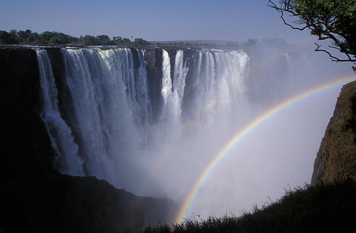
Rainbow
Falls (Zimbabwe): Named for frequent rainbows, with a 108-meter drop,
the highest point.
Eastern Cataract (Zambia): A broad cascade visible
from Livingstone Island.
Gorges: Below the falls, the Zambezi zigzags
through six narrow, steep-sided gorges (First to Sixth), carved by
erosion over millennia as the falls retreated upstream. The Batoka
Gorge, downstream, is a hotspot for white-water rafting.
Spray and
Mist: The falls’ mist rises up to 400 meters, visible from 50 km away,
and creates a microclimate supporting lush rainforest along the gorge
rims.
Islands: Livingstone Island (Zambia) and Cataract Island
(Zimbabwe) sit at the falls’ edge, offering exclusive viewpoints.
Smaller islands fragment the flow during low water levels
(September–December).
Zambezi River: The river’s flow varies
dramatically, from 300 m³/s in the dry season to 10,000 m³/s at peak
flood, shaping the falls’ appearance and surrounding ecosystems.
The
falls’ formation is tied to tectonic activity and erosion. The Zambezi’s
basalt plateau, fractured by faults, allowed the river to exploit weaker
zones, creating the gorges and causing the falls to migrate 8 km
upstream over 100,000 years. The current site is geologically stable,
but erosion continues to shape the landscape.
The Victoria Falls area, including the national parks on both sides
(Mosi-oa-Tunya: 66 km²; Victoria Falls: 23 km²), supports diverse
ecosystems influenced by the Zambezi’s seasonal flooding and the falls’
mist. The region transitions from riverine habitats to savanna and
mopane woodlands, with the falls’ spray fostering a unique rainforest
microhabitat.
Flora: The mist-sustained rainforest along the
falls’ rim features evergreen species like Ficus sycomorus (sycamore
fig), Diospyros mespiliformis (ebony), and Trichilia emetica (mahogany),
with ferns, lianas, and orchids. Beyond the falls, mopane
(Colophospermum mopane), acacia (Acacia spp.), and baobab (Adansonia
digitata) dominate the savanna. The Zambezi’s banks support riverine
grasses and papyrus (Cyperus papyrus).
Mammals: The national parks
host 80+ mammal species, though megafauna are less abundant than in
nearby Hwange or Chobe. Key species include:
Elephants (Loxodonta
africana): Frequently cross the Zambezi between Zambia and Zimbabwe,
visible near lodges.
Buffalo (Syncerus caffer): Small herds roam the
savanna.
Hippopotamus (Hippopotamus amphibius): Common in the Zambezi
above and below the falls.
Antelopes: Bushbuck (Tragelaphus
scriptus), impala (Aepyceros melampus), and waterbuck (Kobus
ellipsiprymnus) graze near the river.
Primates: Chacma baboons (Papio
ursinus) and vervet monkeys (Chlorocebus pygerythrus) are abundant,
often interacting with tourists.
Predators: Lions (Panthera leo) and
leopards (Panthera pardus) are present but elusive; crocodiles
(Crocodylus niloticus) thrive in the river.
Birds: Over 400 bird
species inhabit the area, with the falls and Zambezi as focal points.
Notable species include:
Taita Falcon (Falco fasciinucha): A rare
raptor nesting in the gorges.
African Fish Eagle (Haliaeetus
vocifer): Iconic along the river.
Trumpeter Hornbill (Bycanistes
bucinator): Common in the rainforest.
Waterbirds: African skimmer
(Rynchops flavirostris), grey-headed gull (Chroicocephalus
cirrocephalus), and rock pratincole (Glareola nuchalis) along the river.
Migrants: European bee-eaters (Merops apiaster) and Amur falcons (Falco
amurensis) arrive November–April.
Reptiles and Amphibians: Nile
crocodiles and monitor lizards (Varanus niloticus) are common, with
snakes like the African rock python (Python sebae). Frogs, such as the
Zambezi river frog (Amietia quecketti), breed in seasonal pools.
Fish: The Zambezi supports 80+ fish species, including tigerfish
(Hydrocynus vittatus), bream (Tilapia spp.), and the rare Zambezi shark
(Carcharhinus leucas), a bull shark adapted to freshwater.
The falls’
mist creates a year-round humid zone, sustaining biodiversity even in
the dry season, while the surrounding parks protect critical habitats
for migratory and resident species.
Managed by the Zimbabwe Parks and Wildlife Management Authority
(ZimParks) and Zambia’s Department of National Parks and Wildlife
(DNPW), the Victoria Falls area faces conservation challenges, including
tourism pressure, urban encroachment, and poaching. Key efforts include:
Habitat Protection: The UNESCO World Heritage status ensures strict
regulations on development near the falls. Mosi-oa-Tunya and Victoria
Falls National Parks limit human activity to preserve ecosystems.
Anti-Poaching: Patrols protect elephants and rhinos (reintroduced in
Zambia), with community programs reducing illegal hunting.
River
Management: The Zambezi River Authority monitors water flow, balancing
hydroelectric dams (e.g., Kariba) with ecological needs. Climate
change-induced droughts threaten water levels, impacting the falls’
flow.
Invasive Species: Control of invasive plants like Lantana
camara protects native flora in the rainforest zone.
Research:
Studies focus on fish ecology, bird migration, and elephant movements,
with transboundary initiatives under the Kavango-Zambezi (KAZA)
Transfrontier Conservation Area linking Zambia, Zimbabwe, Botswana,
Namibia, and Angola.
Challenges include over-tourism (1 million
visitors annually), litter, and noise pollution from helicopters, which
stress wildlife. Sustainable tourism initiatives, like eco-lodges and
community-based projects, aim to mitigate impacts.
Victoria Falls is a global adventure capital, offering activities
centered on the falls, Zambezi River, and surrounding parks. The towns
of Victoria Falls (Zimbabwe) and Livingstone (Zambia) serve as bases,
with distinct experiences on each side. Key activities include:
Viewing the Falls:
Zimbabwe Side: Victoria Falls National Park offers
16 viewpoints along a 1.7-km trail, including Devil’s Cataract and
Danger Point. The Main Falls’ mist is most intense, with rainbows
frequent. Entry: $20–$30.
Zambia Side: Mosi-oa-Tunya National Park
provides closer access to the Eastern Cataract and Knife-Edge Bridge,
with the Boiling Pot trail descending to the gorge. Entry: $10–$20.
Lunar Rainbow Tours: Nighttime tours during full moons (February–May)
showcase rare lunar rainbows in the mist ($40–$60).
Devil’s Pool: A
natural rock pool at the edge of the falls on Livingstone Island
(Zambia), accessible by boat during low water (August–December).
Swimmers perch meters from the drop ($100–$150).
White-Water Rafting:
The Batoka Gorge’s Grade 5 rapids offer world-class rafting, with
full-day ($150–$200) or multi-day trips. Best from August to December.
Bungee Jumping: A 111-meter jump from the Victoria Falls Bridge, one of
the world’s highest, costs $160–$200.
Helicopter and Microlight
Flights: “Flight of Angels” tours (15–30 minutes, $150–$350) provide
aerial views of the falls, gorges, and Zambezi.
Zambezi River
Cruises:
Sunset Cruises: 2-hour trips above the falls with drinks and
wildlife sightings ($50–$80).
Canoeing: Guided canoe safaris
($100–$150) offer hippo and bird encounters.
Game Drives and Walking
Safaris: Mosi-oa-Tunya (Zambia) offers rhino tracking and elephant
sightings; Victoria Falls National Park (Zimbabwe) has buffalo and
antelope. Costs: $50–$150.
Cultural Tours: Visits to Mukuni or
Simonga villages (Zambia) or Ndebele communities (Zimbabwe) showcase
Tonga and Ndebele traditions, crafts, and dances ($30–$60).
Adventure
Activities: Ziplining, gorge swinging, and abseiling in the gorges
($50–$100).
Victoria Falls Bridge Tour: Historical and engineering
tours of the 1905 bridge, with views of the Second Gorge ($40–$60).
Accommodations range from luxury lodges (Victoria Falls Hotel, Royal
Livingstone) to budget hostels and campsites. Victoria Falls town is
more developed, with restaurants and nightlife; Livingstone offers a
quieter, colonial charm. The KAZA UniVisa ($50) allows seamless border
crossings for multi-country itineraries.
The region’s subtropical climate features a wet season
(November–April) and dry season (May–October). Temperatures range from
10–25°C (50–77°F) in winter (June–August) to 20–35°C (68–95°F) in summer
(October–March). Rainfall averages 700–900 mm, peaking in February.
High Water (February–May): The falls are at peak flow, with maximum
mist and rainbows, but heavy spray can obscure views. Best for
photography and lunar rainbow tours.
Low Water (September–December):
Reduced flow reveals the basalt cliff’s structure, ideal for Devil’s
Pool, rafting, and Zambia-side views. Some Zimbabwe viewpoints may be
dry.
Shoulder Seasons (June–August, January): Balanced flow and
weather, with fewer crowds and good wildlife viewing.
Game viewing is
best in the dry season, when animals concentrate near the Zambezi.
Rafting and Devil’s Pool are seasonal, requiring planning.
Air: Victoria Falls Airport (Zimbabwe) and Harry Mwanga Nkumbula
International Airport (Livingstone, Zambia) receive flights from
Johannesburg, Nairobi, and Harare. Transfers to the falls take 20–30
minutes ($20–$50).
Road: From Harare (870 km, 12 hours) or Bulawayo
(440 km, 6 hours) to Victoria Falls town; from Lusaka (480 km, 7 hours)
to Livingstone. Buses and private transfers are available.
Border:
The Victoria Falls Bridge connects Zimbabwe and Zambia, with efficient
immigration posts. A KAZA UniVisa simplifies travel.
Infrastructure:
Well-maintained trails, viewpoints, and visitor centers exist on both
sides. The towns offer ATMs, fuel, and medical facilities, but Wi-Fi can
be unreliable.
The falls are sacred to the Tonga, Batoka, and Ndebele peoples, who associate them with spiritual ancestors and rituals. The name Mosi-oa-Tunya reflects the mist’s thunderous presence. European explorer David Livingstone “discovered” the falls in 1855, naming them after Queen Victoria, though local communities had revered them for centuries. The Victoria Falls Bridge, built in 1905, was a colonial engineering feat, linking Cecil Rhodes’ Cape-to-Cairo railway vision. The area’s history includes colonial exploitation, but post-independence Zambia and Zimbabwe have reclaimed the falls as a shared heritage, promoting tourism and conservation.
Permits: Park entry fees ($10–$30) are payable at gates. Activity
bookings through operators like Shearwater or Wild Horizons ensure
permits.
Gear: Bring waterproof clothing, sturdy shoes, sunscreen,
and insect repellent. Light layers suit variable weather; ponchos are
provided at viewpoints.
Health: Malaria prophylaxis is essential,
especially in the wet season. Yellow fever vaccination may be required.
Stay hydrated and avoid river edges due to crocodiles.
Safety: Follow
guides’ instructions for activities like rafting or bungee jumping.
Beware of baboons snatching food at viewpoints.
Currency: USD is
widely accepted in both countries; carry small bills for tips and fees.
Sustainability: Choose eco-certified operators and avoid feeding
wildlife. Support local crafts to benefit communities.