Location: West Nusa Tenggara Map
Area: 413.30 km²
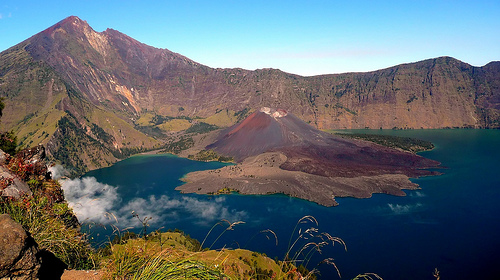
Gunung Rinjani National Park, located on the island of Lombok in West Nusa Tenggara, Indonesia, is a UNESCO Global Geopark and one of the country’s most spectacular natural reserves. Covering approximately 41,330 hectares, the park is centered around Mount Rinjani, Indonesia’s second-highest volcano at 3,726 meters, and its stunning caldera, which houses the sacred Segara Anak Lake and an active volcanic cone, Barujari. Established in 1997, the park is renowned for its dramatic landscapes, rich biodiversity, cultural significance, and challenging trekking routes.
Gunung Rinjani National Park spans the northern part
of Lombok, encompassing Mount Rinjani and its surrounding ecosystems
across three regencies: West Lombok, Central Lombok, and East Lombok.
The park’s volcanic terrain, shaped by millions of years of tectonic
activity along the Sunda Arc, is a geological masterpiece.
Mount
Rinjani:
At 3,726 meters, Rinjani is an active stratovolcano, second
only to Mount Kerinci in height among Indonesian volcanoes. Its
prominence and isolation make it a striking feature, visible from Bali
on clear days.
The volcano’s massive caldera, formed by a
catastrophic eruption around 1257 CE (one of the largest in the last
millennium), measures 6 by 8.5 kilometers and sits at ~2,000 meters
elevation. Within it lies Segara Anak Lake (Child of the Sea), a
turquoise crater lake covering 11 square kilometers, with depths up to
230 meters.
Inside the caldera, Barujari (New Finger), an active
parasitic cone, has erupted multiple times (most recently in 2016),
shaping the lake’s eastern shore with lava flows and hot springs (Aik
Kalak).
Rinjani’s slopes feature steep ridges, volcanic ash fields,
and savanna-like plateaus, with the summit offering views of Lombok,
Bali’s Mount Agung, and the Gili Islands.
Other Geological
Features:
The park includes waterfalls like Sendang Gile and Tiu
Kelep, fed by Rinjani’s springs, and hot springs near the lake, revered
for their healing properties.
The Samalas eruption of 1257, linked to
Rinjani, caused global climate impacts and is believed to have
contributed to the “Year Without a Summer” in 1816. Lava flows and
pyroclastic deposits from past eruptions are visible on trekking routes.
The park serves as a critical watershed, with springs and rivers
supporting Lombok’s agriculture and water needs.
The park’s altitude range (600–3,726 meters) and
varied climates—from tropical lowland forests to subalpine zones—support
a diverse array of flora and fauna, though volcanic activity and human
pressures limit some populations.
Flora:
Lowland Forests
(600–1,500 meters): Tropical rainforests dominate, with species like
Ficus (fig trees), Duabanga moluccana (benuang), and orchids.
Dipterocarp trees and ferns thrive in humid areas.
Montane Forests
(1,500–2,500 meters): Edelweiss (Anaphalis javanica), Casuarina
junghuhniana (mountain casuarina), and pines appear as forests thin out.
Subalpine Zones (>2,500 meters): Grasses, shrubs, and hardy plants like
Imperata cylindrica (cogon grass) dominate near the summit, where
volcanic soils limit growth.
The caldera’s microclimate supports
unique aquatic plants around Segara Anak.
Fauna:
Mammals: The
park is home to the Rinca deer (Rusa timorensis), wild boar (Sus
scrofa), and the endangered Ebony leaf monkey (Trachypithecus auratus).
The critically endangered Javan leopard (Panthera pardus melas) is
present but rarely seen.
Birds: Over 80 species are recorded,
including the Rinjani scops owl (Otus jolandae), an endemic species
discovered in 2003, and the Crested hawk-eagle (Nisaetus cirrhatus).
Birdwatching is popular in lower zones.
Reptiles and Amphibians:
Lizards like Bronchocela jubata and frogs inhabit forested areas and
streams. The lake and hot springs support unique aquatic ecosystems.
Invertebrates: Butterflies and beetles add to the park’s biodiversity,
though studies are limited compared to vertebrates.
Conservation
Significance:
The park protects endemic species and serves as a
refuge for endangered fauna. Its forests act as carbon sinks and
stabilize Lombok’s water supply.
Threats like illegal logging and
poaching necessitate ongoing monitoring, with community-based
conservation programs involving Sasak villagers.
The park is deeply intertwined with the culture of Lombok’s Sasak
people (predominantly Muslim) and the island’s Hindu-Balinese
minority, for whom Rinjani is a sacred site.
Sasak and
Hindu-Balinese Traditions:
Mount Rinjani is considered a dwelling
place of deities, particularly by the Sasak, who call Segara Anak
Lake a spiritual center. Pilgrims visit the lake to pray, leave
offerings, and bathe in hot springs, believed to cure ailments.
The Hindu-Balinese community reveres Rinjani as one of three sacred
peaks (with Bali’s Agung and Batur), associating it with Lord
Vishnu. Annual ceremonies involve offerings at the lake and summit.
The Sasak village of Sembalun, a trekking gateway, preserves
traditional weaving and agricultural practices, offering cultural
immersion for visitors.
Pura and Sacred Sites:
Small
shrines (pura) dot the park, particularly near Segara Anak, where
pilgrims tie prayer flags and perform rituals. The lake’s fish,
Mujair (tilapia), are considered sacred and protected from fishing.
Puncak Dewi Anjani, a peak near the summit, is named after the
mythological goddess Anjani, mother of Hanuman in Hindu lore,
reflecting the park’s spiritual resonance.
Historical
Context:
The 1257 Samalas eruption reshaped Lombok’s demographics
and culture, with evidence suggesting it devastated local kingdoms.
Archaeological sites in Sembalun, like ancient rice terraces, hint
at pre-eruption civilizations.
The park’s UNESCO Global Geopark
status (2018) recognizes its geological and cultural heritage,
promoting sustainable tourism.
Gunung Rinjani National Park offers a range of experiences, from
world-class trekking to serene waterfall visits, appealing to
adventurers, nature lovers, and cultural explorers.
Trekking
Mount Rinjani:
Routes: The two main trails are Sembalun (eastern
route, starting at 1,156 meters, scenic with savanna views) and Senaru
(northern route, starting at 600 meters, through dense forests). Both
lead to the caldera rim, lake, and summit, with 2–4 day itineraries.
Sembalun Route: Ideal for summit attempts, it crosses open plateaus
(Plawangan Sembalun at 2,639 meters) and takes 7–9 hours to the rim. The
summit push (3–4 hours) is steep and rocky.
Senaru Route: Shorter to
the rim (Plawangan Senaru at 2,641 meters), it’s popular for lake and
hot spring visits. The trail passes waterfalls and forests.
Highlights:
Segara Anak Lake: A serene spot for camping, fishing
(with permits), and soaking in hot springs.
Barujari Cone: A half-day
hike from the lake, offering views of active volcanic vents.
Summit:
The final 1,000-meter ascent is grueling, with loose scree and cold
winds, but rewards with panoramic views of Lombok and beyond.
Challenges: The trek is physically demanding, with altitude sickness
risks, unpredictable weather (0–10°C at night), and limited water
sources. Guides and porters are mandatory.
Waterfalls:
Sendang
Gile and Tiu Kelep (near Senaru): These cascading falls, accessible via
short hikes, are fed by Rinjani’s springs. Tiu Kelep, with its misty
pool, is a highlight for swimmers and photographers.
Benang Stokel
and Benang Kelambu (Central Lombok): Outside the park but linked to
Rinjani’s watershed, these falls are known for their curtain-like flow
and lush surroundings.
Camping and Stargazing:
Camping at
Plawangan Sembalun, Plawangan Senaru, or near Segara Anak offers
stunning night skies, with minimal light pollution. The caldera’s
microclimate creates unique cloud formations.
Organized tours provide
tents, meals, and equipment, with porters carrying loads (a local
tradition supporting Sasak livelihoods).
Cultural Experiences:
Visit Sembalun or Senaru villages for Sasak weaving demonstrations,
traditional gamelan music, or homestays. The Sembalun Agro Festival
(seasonal) showcases local culture and produce.
Participate in guided
tours to sacred sites, respecting pilgrimage rituals.
Access and Transportation:
From Lombok: The park is accessible
from Mataram (1.5–2 hours to Senaru or Sembalun) or Lombok International
Airport (2–3 hours). Public buses or private cars reach base villages,
with ojek (motorbike taxis) for final legs.
From Bali: Ferries or
fast boats to Lombok (Padangbai to Lembar, 4–5 hours or 1.5 hours)
connect to overland transport. Flights from Bali to Lombok are quicker
(~40 minutes).
Base Villages: Senaru and Sembalun have guesthouses,
trekking agencies, and equipment rentals. Sembalun is closer to summit
routes, Senaru to waterfalls.
Permits and Costs:
Entry
requires a permit (~IDR 150,000–250,000 for foreigners, ~IDR 5,000 for
locals), payable at trailheads or online via eRinjani (the park’s
booking system). Trekking packages (2D/1N or 3D/2N) cost $150–$300,
including guides, porters, meals, and gear.
Strict quotas (150–200
trekkers daily) and mandatory health checks (no heart/lung issues) apply
since 2018 to reduce environmental strain.
Best Time to Visit:
The dry season (April–October) is ideal for trekking, with clear skies
and stable trails. July–August is peak season, requiring early bookings.
The park closes for trekking from January–March (rainy season) due to
landslides and flooding risks.
Waterfall visits are year-round, with
wet season enhancing flow but complicating access.
Accommodation:
Pre/Post-Trek: Guesthouses and homestays in Senaru (e.g., Rinjani
Lighthouse) and Sembalun (e.g., Sembalun Agro Villa) offer budget to
mid-range options. Mataram has hotels for urban comfort.
On-Trail:
Camping is standard, with designated sites at rim and lake. Luxury
“glamping” options are emerging but less common.
Safety and
Preparation:
Trekking: The summit climb is strenuous, with loose
scree, high altitude, and cold nights (bring layers, headlamps, and
sturdy boots). Water is scarce above the rim; porters carry supplies.
Guides ensure navigation and safety.
Volcanic Activity: Barujari’s
2015–2016 eruptions closed the park temporarily. As of June 2025, no
major activity is reported, but check MAGMA Indonesia or park updates.
Evacuation routes are marked.
Health: Altitude sickness and
dehydration are risks. Acclimatize in base villages and carry first-aid
kits. Wildlife (monkeys, snakes) is non-aggressive but requires caution.
Conservation and Etiquette:
Respect sacred sites by avoiding
littering or fishing in Segara Anak without permits. Follow the “pack
in, pack out” rule, as waste is a major issue (fines apply since 2018).
Support local guides and porters, who rely on tourism. Avoid
unregistered operators to ensure eco-compliance.
Dress modestly in
villages and during rituals, honoring Sasak and Hindu customs.
The park faces significant environmental pressures, despite its
protected status and UNESCO recognition:
Tourism Impact: Over
50,000 annual trekkers (pre-COVID figures) cause trail erosion,
littering, and strain on water sources. Plastic waste around Segara Anak
led to stricter regulations in 2018.
Deforestation and Poaching:
Illegal logging and hunting threaten forests and wildlife, particularly
in lower zones. Community patrols and reforestation programs aim to curb
this.
Natural Hazards: Landslides, flash floods, and Barujari
eruptions disrupt ecosystems and tourism. The 2018 Lombok earthquakes
(magnitude 6.9) damaged trails and villages, highlighting vulnerability.
Conservation Efforts: The Rinjani Ecotourism Management System
(eRinjani) caps trekker numbers, enforces waste removal, and funds trail
maintenance. Community-based tourism employs Sasak locals, reducing
reliance on logging. UNESCO’s Geopark status promotes sustainable
development.