Location: East Nusa Tenggara, Flora Island Map
Area: 50 km²
Kelimutu National Park, located on the island of Flores in East Nusa Tenggara, Indonesia, is a compact yet extraordinary natural reserve renowned for its unique tri-colored crater lakes atop Mount Kelimutu. Covering approximately 5,300 hectares, the park, established in 1992, is a geological wonder, a biodiversity hotspot, and a cultural treasure for the local Lio people. The park’s centerpiece, the three volcanic lakes—each with distinct, changing colors due to mineral interactions—draws adventurers, scientists, and spiritual seekers.
Kelimutu National Park is situated in the Ende
Regency, about 60 km northeast of Ende town and 13 km from Moni village,
the primary gateway. The park’s landscape is dominated by Mount
Kelimutu, a dormant volcano standing at 1,639 meters, and its
surrounding forested slopes and volcanic terrain.
Mount Kelimutu
and the Tri-Colored Lakes:
Mount Kelimutu, part of the Lesser Sunda
Islands’ volcanic arc, is a complex volcano with a summit caldera
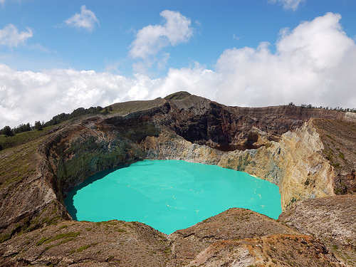
containing three crater lakes: Tiwu Ata Bupu (Lake of Elders), Tiwu Ko’o
Fai Nuwa Muri (Lake of Young Men and Maidens), and Tiwu Ata Polo
(Bewitched or Enchanted Lake).
The lakes are the park’s defining
feature, each displaying distinct colors that change periodically due to
chemical reactions involving volcanic gases, minerals (e.g., iron,
manganese), and microbial activity. Colors range from turquoise, green,
blue, red, brown, to black, with historical records noting shifts over
decades (e.g., Tiwu Ata Polo was red in the 1980s, turquoise in 2023).
Tiwu Ata Bupu: Typically blue or green, located on the western side,
separated from the others by a crater wall.
Tiwu Ko’o Fai Nuwa Muri:
Often turquoise or green, shares a crater wall with Tiwu Ata Polo.
Tiwu Ata Polo: Frequently darker (red, brown, or black), known for its
mystical aura.
The lakes’ depths are estimated at 60–150 meters, with
high mineral content making them acidic and uninhabitable for most
aquatic life. Their proximity (within 1.5 km) and elevation (~1,600
meters) create a surreal, compact spectacle.
Kelimutu’s last eruption
was in 1968, a phreatic event (steam-driven), and it remains dormant,
with minor seismic activity monitored by Indonesia’s volcanology agency.
Other Geological Features:
The park includes volcanic cones,
fumaroles, and hot springs on Kelimutu’s flanks, indicating residual
geothermal activity. The surrounding terrain features rolling hills,
ravines, and fertile valleys used for agriculture.
The park is part
of the Kelimutu-Wolowaru volcanic complex, with older lava flows and
pyroclastic deposits shaping the landscape.
As a headwater for local
rivers, the park supports rice paddies and communities in Moni and
nearby villages.
Despite its small size, Kelimutu National Park’s
altitude range (800–1,639 meters) and tropical climate foster diverse
ecosystems, from lowland rainforests to montane forests. Volcanic soils
and human activity limit biodiversity in some areas, but the park
remains a haven for endemic species.
Flora:
Lowland Forests
(800–1,200 meters): Tropical rainforests dominate, with species like
Ficus (fig trees), Pandanus (screw pines), and Canarium (kenari trees).
Orchids and ferns thrive in humid zones.
Montane Forests (1,200–1,639
meters): Smaller trees like Casuarina (cemara) and Toona sureni (suren)
appear, with mosses and epiphytes near the summit. The rare Begonia
kelimutuensis, an endemic begonia, grows on crater slopes.
Volcanic
Zones: Sparse vegetation around the lakes includes grasses and shrubs
adapted to acidic soils, similar to subalpine zones in larger parks like
Rinjani.
Fauna:
Mammals: The park hosts small populations of
the Flores giant rat (Papagomys armandvillei), an endemic species, as
well as bats and civets. Larger mammals like deer are scarce due to
habitat size and hunting.
Birds: Over 50 species are recorded,
including the endemic Flores scops owl (Otus alfredi) and Wallace’s
hanging parrot (Loriculus flosculus). The park is part of the Endemic
Bird Area of Flores, attracting birdwatchers.
Reptiles and
Amphibians: Lizards (Draco flying lizards) and frogs inhabit forested
areas, with studies noting high endemism due to Flores’ isolation.
Invertebrates: Butterflies, such as the Flores crow butterfly (Euploea
floresiana), add vibrancy, with unique species adapted to volcanic
soils.
Conservation Significance:
The park protects endemic
species and serves as a critical watershed for Flores’ agriculture. Its
forests stabilize soils, preventing erosion on steep slopes.
The
lakes’ unique chemistry is studied for microbial extremophiles,
contributing to global volcanology research.
Kelimutu National Park is deeply significant to the Lio people,
the indigenous inhabitants of central Flores, who view the lakes as
a spiritual realm. The park also reflects Flores’ broader cultural
tapestry, shaped by its Austronesian heritage and Catholic
influence.
Lio Beliefs and Traditions:
The Lio believe the
lakes are resting places for souls after death:
Tiwu Ata Bupu:
Houses the souls of elders, symbolizing wisdom and peace.
Tiwu
Ko’o Fai Nuwa Muri: Holds the souls of youths, representing
vitality.
Tiwu Ata Polo: Contains the souls of sinners or
sorcerers, associated with mystery and malevolence.
The lakes’
color changes are interpreted as omens or reflections of ancestral
moods, prompting rituals to honor spirits. The Lio perform
ceremonies (pati ka) involving offerings of betel nut, rice, and
slaughtered animals to appease ancestors.
Mount Kelimutu is
considered a sacred Gunung Adat (customary mountain), with taboos
against littering or loud behavior near the lakes.
Cultural
Sites:
Traditional Lio villages like Woloalung and Pajuria, near
Moni, feature conical-roofed houses (sa’o) and megalithic altars
used for rituals. These villages offer homestays and cultural tours.
The Moni Market, held weekly, showcases Lio textiles (ikat weaving)
and local produce, reflecting Flores’ vibrant craft traditions.
Historical Context:
Flores’ isolation preserved Lio customs,
but Portuguese and Dutch colonial influences (16th–19th centuries)
introduced Catholicism, evident in Moni’s churches. The park’s
modern tourism began in the 1980s, boosted by Indonesia’s
conservation efforts.
Kelimutu’s lakes were first documented by
Dutch geologist Reinout van Lier in 1911, sparking global interest.
The park’s designation in 1992 aimed to balance tourism with
preservation.
Kelimutu National Park offers a mix of scenic beauty, cultural
immersion, and light adventure, centered on the lakes and surrounding
villages.
Visiting the Tri-Colored Lakes:
The primary
attraction is viewing the lakes from Inspiration Point (Puncak Yos
Sudarso), a short 1.5-km walk or drive from the park entrance at 1,400
meters. A 15-minute staircase climb leads to the summit viewpoint,
offering panoramic lake vistas.
Sunrise Viewing: The most popular
activity, with dawn (5:30–6:30 AM) casting ethereal light on the lakes,
often framed by mist. The experience is less physically demanding than
Bromo’s sunrise viewpoints but equally stunning.
The lakes’ colors
vary unpredictably, making each visit unique. As of 2023, Tiwu Ata Bupu
was blue, Tiwu Ko’o Fai Nuwa Muri turquoise, and Tiwu Ata Polo dark
green, but updates are needed for 2025.
Hiking and Exploration:
Short Trails: The park offers easy trails around the summit, with
boardwalks and stone paths to viewing platforms. A 2-km loop from the
entrance explores forested slopes and volcanic features.
Longer
Hikes: Guided treks to Kelimutu’s lower flanks visit hot springs, rice
terraces, and villages like Woloalung. These 3–5 hour hikes suit
moderate fitness levels.
Unlike Rinjani or Ciremai, Kelimutu has no
summit treks due to the lakes’ accessibility, making it ideal for
families or less experienced hikers.
Cultural Experiences:
Lio
Villages: Tours to Woloalung or Saga village include demonstrations of
ikat weaving, traditional dances, and Lio cuisine (e.g., jagdung,
corn-based dishes). Homestays immerse visitors in daily life.
Ritual
Observations: With permission, visitors can observe Lio ceremonies near
the lakes or in villages, respecting cultural protocols (e.g., silence,
modest attire).
Nearby Attractions:
Murundao Waterfall: A
30-minute drive from Moni, this multi-tiered fall is ideal for picnics
and photography.
Wologai Traditional Village: A preserved Lio
settlement with megalithic structures, 20 km from Moni.
Hot Springs
in Moni: Natural pools like Kolorongo offer relaxation after hikes.
Access and Transportation:
From Ende: The park is 60 km (2–3 hours
by car) from Ende’s H. Hasan Aroeboesman Airport, reachable via taxis or
bemo (minivans). Moni, 13 km from the park, is the main base.
From
Labuan Bajo: A 10–12 hour drive or bus ride (via Trans-Flores Highway)
connects Flores’ western tourism hub to Moni. Daily flights from Labuan
Bajo to Ende (~1 hour) are faster.
Within the Park: Motorbike taxis
(ojek) or private cars from Moni reach the park entrance. The final 1.5
km to Inspiration Point is walkable or drivable (parking fee ~IDR
10,000).
Permits and Costs:
Entry costs ~IDR 150,000 for
foreigners (~IDR 5,000 for locals), payable at the gate. Guided tours
(optional) range from $10–$30, covering lake visits or village treks.
No quotas or health checks apply, unlike Rinjani’s strict regulations,
but group sizes are limited to reduce environmental impact.
Best
Time to Visit:
The dry season (April–October) offers clear skies and
stable trails, ideal for sunrise views. June–August is peak season, with
more crowds but vibrant village festivals.
The wet season
(November–March) enhances lake vibrancy but brings fog and slippery
paths, reducing visibility.
Accommodation:
Moni: Budget
guesthouses (e.g., Kelimutu Eco Lodge, Antoneri Lodge) and homestays
cost $10–$50/night. Most offer lake tour packages and early breakfasts
for sunrise trips.
Ende: Mid-range hotels like Grand Wisata provide
urban comfort for those exploring Flores broadly.
No camping is
allowed near the lakes, unlike Rinjani or Ciremai, due to sacred
restrictions.
Safety and Preparation:
Hiking: Trails are short
and well-maintained, but sturdy shoes and rain gear are advised,
especially in the wet season. Fog can obscure views, so check weather
forecasts.
Volcanic Activity: Kelimutu is dormant, with no eruptions
since 1968. Minor tremors occur, but the park is safe as of June 2025,
per volcanology reports. Check MAGMA Indonesia for updates.
Health:
Altitude is moderate (~1,600 meters), posing low risk of sickness. Bring
sunscreen, hats, and water, as shade is limited at the summit.
Wildlife: Monkeys and birds are non-aggressive but may approach food.
Keep valuables secure.
Conservation and Etiquette:
Respect Lio
beliefs by avoiding loud behavior or littering near the lakes, which are
sacred. Plastic waste is a concern; carry out all trash.
Support
local guides and artisans (e.g., buying ikat textiles) to bolster the
economy. Use licensed operators to ensure eco-compliance.
Dress
modestly in villages and during ceremonies, honoring Lio and Catholic
traditions.
Kelimutu National Park faces environmental pressures despite its
small size and protected status:
Tourism Impact: ~30,000 annual
visitors (pre-COVID estimate) strain trails and facilities, with
littering near the lakes a persistent issue. Signage and waste bins have
improved since 2015, but enforcement is limited.
Deforestation:
Illegal logging and agricultural expansion (coffee, cloves) encroach on
lower zones, reducing forest cover. Reforestation programs involve Lio
communities but progress is slow.
Climate Change: Altered rainfall
patterns affect lake chemistry and forest health, with studies noting
potential impacts on color changes. Erosion on trails is worsening.
Conservation Efforts: The park collaborates with NGOs and the Indonesian
government to monitor biodiversity and restore degraded areas.
Community-based tourism empowers Lio villagers to protect their land,
with initiatives like the Kelimutu Festival promoting eco-awareness.