Location: East Kalimantan Map
Area: 1,986 km² (767 mi²)
Kutai National Park, located on the east coast of Borneo in East Kalimantan, Indonesia, is a lowland tropical rainforest reserve spanning approximately 198,629 hectares (2,000 km²). Established in 1982, it is one of Indonesia’s oldest national parks, created to protect a vital ecosystem that has faced significant deforestation, mining, and fire damage since the 1970s. The park is renowned for its rich biodiversity, including a significant population of critically endangered Bornean orangutans, diverse flora, and unique coastal and riverine landscapes. Situated north of the Mahakam River, it lies adjacent to the towns of Bontang and Sangatta, about 120 km north of the provincial capital, Samarinda.
Kutai National Park occupies a lowland region 10–50 km
north of the equator, characterized by flat topography (92% of the area)
and minor hilly zones (8%). It is part of the Kutai Basin, a
Tertiary-age extensional basin formed in the mid-Eocene, with depths up
to 15 km, making it Indonesia’s largest and deepest sedimentary basin.
Landscape and Waterways:
The park stretches from coastal plains
to gentle hills, encompassing mangrove swamps, freshwater lakes (Danau
Maau, Santan, Besar, Sirapan), and rivers like the Palakan, Banu Muda,
Teluk Pandan, Melawan, and Sangatta. The Mahakam River, a major regional
artery, forms the park’s southern boundary.
Coastal areas feature
coral reefs and alluvial sedimentary rocks, the central zone has upper
Miocene rocks, and the western hills contain lower sedimentary rocks.
Key bays, such as Kaba Bay and Lombok Bay, and estuaries like Sangkimah
and Sangatta, support mangrove ecosystems and marine tourism.
Geological Context:
The park lies on the Sunda micro-plate, shaped by
Cenozoic tectonics involving subduction of the Indo-Australian Plate
under the Eurasian Plate.
The Mahakam River delta, prograding
eastward into the Makassar Strait, has deposited thick Neogene sediments
(up to 9 km), influencing the park’s flat, fertile terrain.
Past
volcanic activity is minimal compared to parks like Kelimutu or Rinjani,
but the basin’s rifting history contributes to its ecological diversity.
Kutai National Park is dominated by Dipterocarpaceae
lowland tropical rainforest, with additional ecosystems including
coastal mangrove forests, freshwater swamp forests, and kerangas (heath)
forests. Despite losing ~70% of its primary forest to logging, mining,
and fires (notably in 1982–83), it remains a biodiversity hotspot.
Flora:
The park hosts 958 plant species, including 8 of the 9
global genera of Dipterocarpaceae (e.g., Shorea [meranti], Dryobalanops
[kapur]), 41 orchid species, and 220 medicinal plants.
Notable trees
include ulin (Eusideroxylon zwageri, Borneo ironwood), reaching 30–35
meters, with a record-breaking specimen at Sangkimah (45 meters tall,
225 cm diameter, 150 m³ volume).
Other species include mangrove
(Bruguiera sp.), sea cypress (Casuarina equisetifolia), Dillenia sp.
(simpur), Octomeles sumatrana (benuang), and three types of Rafflesia
(carrion flowers). The park is home to Indonesia’s largest ulin forest.
Compared to Kelimutu’s montane forests or Rinjani’s subalpine zones,
Kutai’s lowland rainforest is denser and more commercially valuable,
contributing to its deforestation challenges.
Fauna:
The park
supports 10 primate species, 90 mammals, and 300 bird species.
Primates: Bornean orangutan (Pongo pygmaeus morio, ~2,000 individuals
per 2010 survey), proboscis monkey (Nasalis larvatus), maroon leaf
monkey (Presbytis rubicunda), white-fronted leaf monkey (Presbytis
frontata), Bornean gibbon (Hylobates muelleri), long-tailed macaque
(Macaca fascicularis), slow loris (Nycticebus coucang).
Mammals:
Malayan sun bear (Helarctos malayanus), clouded leopard (Neofelis
nebulosa), marbled cat (Pardofelis marmorata), flat-headed cat
(Pardofelis planiceps), sambar deer (Cervus unicolor), banteng (Bos
javanicus), black flying squirrel (Aeromys tephromelas), smooth-coated
otter (Lutrogale perspicillata).
Birds: Hornbills, lesser adjutant
stork (Leptoptilos javanicus), white-bellied sea eagle (Haliaeetus
leucogaster), green imperial pigeon (Ducula aenea), hill myna (Gracula
religiosa), oriental darter (Anhinga melanogaster).
Orangutan
populations fluctuated from 600 in 2004 to ~60 in 2009, but a 2010
survey estimated 1,000–2,000, indicating recovery in less-disturbed
areas like Prevab-Mentoko.
Unlike Kelimutu’s island-specific endemics
(e.g., Flores scops owl), Kutai shares Borneo’s megafauna with Tanjung
Puting but lacks the volcanic lake ecosystems of Rinjani or Kelimutu.
Conservation Significance:
The park is a critical refuge for the
endangered morio orangutan, with the Orangutan Kutai Project (launched
2009) studying their behavior and habitat needs.
Its diverse
ecosystems support research on lowland rainforest resilience, though
only 30% of primary forest remains.
Compared to Ciremai’s Javan
leopard focus or Bromo’s subalpine flora, Kutai’s primate diversity and
ulin forests are unique but heavily threatened.
Kutai National Park lies in a region with deep historical and
cultural roots, tied to the Kutai people and Bugis settlers, within
the historical Kutai Martadipura Kingdom (399–1635 CE).
Kutai
People and Bugis Communities:
The park contains traditional Bugis
settlements, descendants of Sulawesi migrants, who live along rivers
and engage in fishing and trade.
The Kutai people (Urang Kutai),
with a population of ~300,000, speak Kutainese and trace their
heritage to the Kutai Martadipura Kingdom, the earliest Hindu
kingdom in Indonesia. The kingdom’s capital, Muara Kaman, near the
Mahakam River, features 4th-century yupa inscriptions in Sanskrit,
evidencing Hindu influence.
The Kutai Kartanegara Sultanate
(1300–1844) succeeded the kingdom, and its sultan still holds
ceremonial status in Tenggarong, though governance is by the
Indonesian state.
Historical Sites:
The yupa pillars
(sacrificial posts) at Muara Kaman, inscribed in Pallava script,
mention rulers like Kudungga, Aśwawarman, and Mulavarman, who
performed Vedic rituals like Ashvamedha. These are among Indonesia’s
oldest written records.
Dayak communities, particularly in nearby
villages like Pampang, preserve cultural practices like longhouse
living and tattooing, accessible via tours from Samarinda.
Cultural Context:
Unlike Kelimutu’s Lio spiritualism (lakes as
soul repositories) or Rinjani’s Sasak/Hindu pilgrimages, Kutai’s
cultural significance is more historical than religious, with no
major sacred sites within the park.
The park’s Bugis and Dayak
communities offer cultural tourism, though less prominent than
Bromo’s Tenggerese festivals or Ciremai’s Sundanese villages.
Kutai National Park offers eco-tourism focused on wildlife, flora,
and riverine adventures, with three main tourism zones: Sangkimah,
Prevab-Mentoko, and coastal bays.
Wildlife Trekking:
Prevab-Mentoko: The primary orangutan viewing area, a 25-minute boat
ride up the Sangatta River from Kabo Pier. Guided treks (2–4 hours)
explore trails where orangutans, gibbons, and birds are spotted. The
area’s relatively pristine forest enhances sightings.
Night Trekking:
Evening walks reveal nocturnal species like tarantulas, owls, slow
lorises, and bullet ants, guided by rangers with keen wildlife detection
skills.
Success rates for orangutan sightings vary; some visitors
report seeing multiple individuals (including babies), while others find
none, reflecting wild populations’ unpredictability.
Flora and
Scenic Trails:
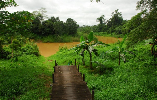
Sangkimah: Features an elevated boardwalk to a massive
ulin tree (over 1,000 years old), showcasing the park’s floral
diversity. The trail is accessible but faces encroachment from nearby
roads.
Adventure tours include suspension bridges, treehouses, and
observation of Rafflesia and orchids, offering immersive rainforest
experiences.
River and Coastal Exploration:
Kaba Bay and
Sangkimah Estuary: Ideal for marine tourism, with opportunities to spot
proboscis monkeys, crocodiles, and sambar deer. Speedboat tours from
Bontang (30 minutes) access these areas.
Lombok Bay and Sangatta
Estuary: Intact mangrove forests provide birdwatching and scenic
cruises, highlighting coastal ecosystems.
Goa Lobang Angin: A cave
near Prevab offers caving for adventurous visitors, though less
developed than other attractions.
Cultural and Dayak Experiences:
Tours to nearby Dayak villages (e.g., Pampang, 30–60 minutes from
Samarinda) showcase longhouses, dances, and crafts, complementing park
visits.
Unlike Kelimutu’s village-based immersion or Rinjani’s Sasak
homestays, Kutai’s cultural offerings are peripheral, with the park
focusing on nature.
Access and Transportation:
From Balikpapan: The park is 8–9 hours
by car to Sangatta’s Kabo Pier, followed by a 25–30 minute motorized
canoe to Prevab. Alternatively, fly to Samarinda (1 hour) and drive 3
hours to Bontang, then 30 minutes by speedboat to Kaba Bay.
From
Samarinda: A 4-hour drive to Sangkimah or 3 hours to Bontang, with
public minibuses or private cars available.
Travel agencies are
recommended, as independent access is challenging due to permit
requirements and remote trails.
Permits and Costs:
Entry fees
are ~IDR 5,000 for locals and ~IDR 150,000 for foreigners, with some
criticism of the price disparity.
Guided tours (2–4 days) cost
$150–$400, including boat transfers, ranger-led treks, meals, and
lodging. Book via operators like Borneo Eco Adventure (+62 548 27218) or
De’gigant Tours, though reviews suggest verifying reliability.
Reservations are advised, especially for Prevab, due to limited lodging
and ranger availability.
Best Time to Visit:
The dry season
(April–October) is ideal for trekking and wildlife spotting, with stable
trails and clear skies. July–August is peak season, requiring early
bookings.
The wet season (November–March) enhances river navigation
but makes trails muddy and increases flood risks, similar to challenges
in Rinjani or Ciremai.
Accommodation:
Prevab: Basic lodging at
the ranger station (Morio Guesthouse), a wooden eco-lodge with 7 rooms,
shared cold-water bathrooms, and electricity from 6–10 PM. Meals are
provided by local cooks.
Sangatta or Samarinda: Hotels (e.g., 3-star
options in Samarinda) offer urban comfort pre/post-trek.
Compared to
Kelimutu’s Moni guesthouses or Rinjani’s village homestays, Kutai’s
facilities are rudimentary, reflecting its remote focus.
Safety
and Preparation:
Trekking: Trails are moderately challenging, with
dense vegetation and risks of getting lost without guides. Bring sturdy
boots, insect repellent, and rain gear.
Wildlife: Orangutans and
monkeys are non-aggressive, but crocodiles in rivers require caution.
Rangers ensure safety during treks.
Health: Malaria is a risk; use
prophylaxis and mosquito nets. No altitude issues, unlike Rinjani or
Ciremai.
Volcanic Activity: None, unlike Kelimutu, Rinjani, or Bromo,
making Kutai seismically safe as of June 2025.
Conservation and
Etiquette:
Avoid plastic waste, as littering is a major issue. A
proposed plastic ban and stricter cleanup efforts are needed.
Respect
Bugis and Dayak customs in settlements, maintaining quiet and modest
behavior. Support local guides to bolster conservation.
Unlike
Kelimutu’s sacred lake taboos or Bromo’s ritual etiquette, Kutai has
fewer cultural restrictions but emphasizes environmental responsibility.
Kutai National Park faces severe threats, with only 30% of its
primary forest intact:
Deforestation: Logging since the 1970s,
mining concessions, and settlements reduced the park from 2 million
hectares in 1934 to ~200,000 by 1997. In 2014, 60,000 hectares were
excised for illegal settlements.
Forest Fires: The 1982–83 Borneo
fires devastated large sections, compounded by El Niño droughts. Smaller
fires persist, threatening ulin forests.
Encroachment: Roads (e.g.,
Bontang-Sangatta) and housing developments encroach on the eastern
boundary, fragmenting habitats.
Conservation Efforts:
The
Orangutan Kutai Project (since 2009) monitors morio orangutans, with a
4-km research site along the Sangatta River showing healthy populations.
Partnerships with “Friends of Kutai” (e.g., PT Kaltim Prima Coal, PT
Badak LNG) fund patrols and reforestation, though critics note conflicts
of interest with mining sponsors.
A civil-military management model,
proposed in 2014, emphasizes institutional strengthening, security
patrols, and community collaboration to curb illegal logging.
Compared to Kelimutu’s tourism-related litter or Rinjani’s trail
erosion, Kutai’s industrial-scale threats (mining, fires) are more
severe, requiring broader policy interventions.