Location: Central Kalimantan Map
Area: 3,550 km2 (1,370 mi²)
Tanjung Puting National Park, located in the Central Kalimantan province of Indonesian Borneo, is a globally significant conservation area renowned for its critical role in orangutan conservation, pristine lowland rainforests, and unique riverine ecosystems. Covering approximately 416,040 hectares, the park was established as a game reserve in 1939 and upgraded to a national park in 1982. It is a UNESCO Biosphere Reserve and one of the world’s most important sites for studying and protecting the endangered Bornean orangutan. Situated along the southern coast of Borneo, the park’s intricate network of rivers, swamps, and forests supports extraordinary biodiversity and offers a unique ecotourism experience centered on wildlife and cultural heritage.
Tanjung Puting National Park lies in the Kumai and
Seruyan regencies, bordered by the Java Sea to the south and the
Sekonyer River and its tributaries to the north. Its coordinates range
from approximately 2°35’–3°20’S and 111°50’–112°15’E. The park’s
topography is predominantly flat, with elevations from sea level to 30
meters, featuring waterlogged swamps and low hills. The climate is
tropical, with high humidity and annual rainfall of 2,400–3,200 mm,
peaking during the wet season (November to April). The dry season (May
to October) reduces river levels, concentrating wildlife along
waterways.
The park encompasses a variety of ecosystems, shaped
by its waterlogged terrain:
Lowland Tropical Rainforests:
Dominating higher ground, these forests feature dipterocarp trees
(Shorea, Dipterocarpus), ironwood (Eusideroxylon zwageri), and a dense
understory of lianas and epiphytes.
Peat Swamp Forests: Covering vast
areas, these waterlogged forests support Shorea balangeran and Dyera
costulata, acting as significant carbon sinks.
Heath Forests
(Kerangas): Found on nutrient-poor, sandy soils, these forests host
stunted trees, pitcher plants (Nepenthes spp.), and orchids.
Mangrove
and Nipa Forests: Along the coast and river estuaries, mangroves
(Rhizophora spp.) and nipa palms (Nypa fruticans) stabilize sediments
and support marine life.
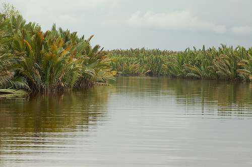
Blackwater Rivers and Oxbow Lakes: The
Sekonyer River and its tributaries, stained dark by tannins from
decaying vegetation, are the park’s lifelines, supporting aquatic
ecosystems and serving as transport routes.
Tanjung Puting is a biodiversity hotspot, with its
diverse habitats supporting a wealth of flora and fauna, including many
endangered and endemic species. Its role as a stronghold for orangutans
makes it a focal point for global conservation.
Flora
The park
hosts over 1,500 plant species, adapted to its wet and nutrient-variable
soils:
Dipterocarps: Canopy giants like Shorea and Hopea species
dominate rainforests, providing food and shelter for wildlife.
Fruit
Trees: Figs (Ficus spp.), rambutan (Nephelium lappaceum), and durian
(Durio spp.) are critical for frugivores like orangutans.
Swamp
Species: Shorea balangeran (red balau) and Melaleuca cajuputi thrive in
peat swamps, used locally for timber and medicine.
Orchids and
Epiphytes: Hundreds of orchid species, ferns, and pitcher plants
flourish in humid forests and heathlands.
Mangroves: Rhizophora
mucronata and Avicennia marina support coastal ecosystems and local
livelihoods.
Fauna
The park’s wildlife is exceptionally
diverse, with a focus on primates, aquatic species, and forest-dependent
fauna:
Mammals:
Bornean Orangutan (Pongo pygmaeus), the park’s
flagship species, with an estimated 6,000–7,000 individuals, one of the
largest wild populations. They are frequently observed at feeding
stations like Camp Leakey, Tanjung Harapan, and Pondok Tanggui.
Proboscis Monkey (Nasalis larvatus), an endangered species with a
distinctive nose, found in mangroves and swamp forests.
Gibbons
(Hylobates agilis), known for their acrobatic movements and
vocalizations.
Clouded Leopard (Neofelis nebulosa), a rare predator,
and Sun Bear (Helarctos malayanus), the smallest bear species.
Other
mammals include Barking Deer (Muntiacus muntjak), Wild Boar (Sus
scrofa), and Pangolin (Manis javanica).
Birds: Over 230 species,
including nine hornbill species like the Rhinoceros Hornbill (Buceros
rhinoceros) and Black Hornbill (Anthracoceros malayanus). Other notables
include the Storm’s Stork (Ciconia stormi), White-bellied Sea Eagle
(Haliaeetus leucogaster), and Kingfishers (Alcedinidae).
Reptiles and
Amphibians: The False Gharial (Tomistoma schlegelii), a critically
endangered crocodilian, inhabits rivers, alongside saltwater crocodiles
(Crocodylus porosus), monitor lizards (Varanus salvator), and numerous
frogs like the Bornean Horned Frog (Megophrys nasuta).
Fish and
Invertebrates: Blackwater rivers support over 100 fish species,
including Betta fighting fish and freshwater shrimp. Insects like
butterflies, dragonflies, and the giant Atlas Moth (Attacus atlas)
abound.
Tanjung Puting is surrounded by Dayak (Ngaju and Ot
Danum) and Malay communities, with about 20,000 people living in
villages along the park’s borders, such as Kumai and Pangkalan Bun.
Their culture and livelihoods are closely tied to the park:
Traditional Practices: Dayak communities practice shifting cultivation,
growing rice, cassava, and fruits, and harvest forest products like
rattan, honey, and medicinal plants.
Fishing: Rivers provide fish
like Channa striata (snakehead), supporting local diets and markets.
Cultural Beliefs: The Sekonyer River and forests are considered sacred,
with rituals to honor spirits. Longhouses and traditional dances reflect
Dayak heritage.
Conservation Legacy: The park is home to Camp Leakey,
founded in 1971 by Dr. Biruté Galdikas, a pioneering orangutan
researcher. It remains a global hub for orangutan rehabilitation and
research.
Tourism Economy: Ecotourism, centered on orangutan viewing
and river tours, employs locals as guides, boat operators, and homestay
hosts. The park attracts over 30,000 visitors annually, boosting the
regional economy.
Tanjung Puting is a premier ecotourism destination,
offering immersive wildlife experiences along its rivers and forests.
Most visits are conducted via klotok boats (traditional wooden vessels),
providing access to remote areas. Key activities include:
Orangutan Viewing: Guided visits to feeding stations at Camp Leakey,
Tanjung Harapan, and Pondok Tanggui, where rehabilitated and wild
orangutans gather for supplemental feeding. These stations offer close
encounters and educational insights.
River Cruises: Multi-day klotok
tours along the Sekonyer River and tributaries, with opportunities to
spot proboscis monkeys, crocodiles, and hornbills from the boat.
Jungle Trekking: Short guided hikes near feeding stations or deeper into
the forest to observe wildlife and explore peat swamps or heath forests.
Birdwatching: The park’s diverse birdlife, especially hornbills and
storks, attracts birders, with prime viewing along rivers and forest
edges.
Night Tours: Evening boat trips to see nocturnal wildlife,
such as fireflies, owls, and fishing bats.
Cultural Experiences:
Visits to Dayak villages like Sekonyer Village for cultural
performances, handicraft purchases, or homestays.
Conservation
Education: Tours often include talks by rangers or researchers about
orangutan behavior and park conservation efforts.
Managed by Indonesia’s Ministry of Environment and Forestry,
Tanjung Puting is a priority for conserving Borneo’s rainforests and
orangutans. Conservation efforts include:
Orangutan
Rehabilitation: Programs like Camp Leakey and the Orangutan
Foundation International (OFI) rehabilitate orphaned or injured
orangutans, releasing them into the wild when possible.
Habitat
Protection: Anti-logging patrols and reforestation to preserve peat
swamps and rainforests, which store vast carbon reserves.
Community Engagement: Training locals in ecotourism and sustainable
agriculture to reduce forest dependency.
Research: Long-term
studies at Camp Leakey on orangutan ecology, social behavior, and
forest dynamics inform global conservation strategies.
Major
challenges include:
Illegal Logging: Despite protections, illegal
timber extraction degrades forests, particularly in buffer zones.
Oil Palm Expansion: Plantations encroach on park boundaries,
fragmenting habitats and increasing human-orangutan conflict.
Mining: Illegal gold mining along rivers pollutes waterways with
mercury, harming aquatic life and human health.
Poaching and
Wildlife Trade: Orangutans and hornbills are targeted for illegal
trade, though enforcement has reduced incidents.
Tourism Impact:
Overcrowding at feeding stations and boat traffic can stress
wildlife, requiring stricter visitor regulations.
Climate Change:
Prolonged dry seasons reduce fruit availability, impacting
orangutans, while peat swamp fires release massive carbon emissions.
Tanjung Puting is accessible via Pangkalan Bun, the nearest major
town in Central Kalimantan:
By Air: Flights to Iskandar Airport
in Pangkalan Bun from Jakarta, Surabaya, or Pontianak (1–2 hours).
By
Land and Water: A 20–30 minute drive from Pangkalan Bun to Kumai port,
followed by a 2–3 hour klotok boat ride along the Sekonyer River to park
entry points like Tanjung Harapan or Camp Leakey.
Within the Park:
Klotok boats are the primary transport, with multi-day tours including
onboard sleeping and dining. Infrastructure includes:
Basic hotels
and homestays in Pangkalan Bun and Kumai.
Klotok boats equipped with
sleeping decks, kitchens, and bathrooms for overnight tours.
Ranger
stations and visitor centers at Tanjung Harapan, Pondok Tanggui, and
Camp Leakey.
Limited internet and electricity in the park, with
better facilities in Pangkalan Bun.