Location: 15 km (10 mi) from Tel Aviv Map
Tel Aphek (also spelled Tel Afek or Aphek; Roman name: Antipatris)
is one of Israel’s most layered and strategically vital archaeological
sites, located in the Yarkon National Park in central Israel’s Sharon
Plain. It sits at the headwaters (springs) of the Yarkon River, near
modern Rosh Ha’Ayin and Petah Tikva, guarding the narrow Afek Pass
along the ancient Via Maris (the international coastal highway linking
Egypt to Mesopotamia and the north).
The tel (mound) rises
prominently above the river’s sources, controlling a critical
2-km-wide corridor between the Samarian hills to the east and the
Yarkon swamps/marshes to the west. Over 6,000 years of continuous
settlement (from the Chalcolithic period ~4500 BCE through the late
Roman era, with later reuse) left behind superimposed cities, palaces,
fortifications, and infrastructure. Today it is a protected national
park blending archaeology, nature, recreation, and trails—popular for
picnics, walks, and family visits.
Biblical Aphek (mentioned in
Joshua, 1 Samuel, and Acts) is this site: the Philistines camped here
before defeating the Israelites and capturing the Ark of the Covenant
at nearby Ebenezer (~1050 BCE), and the Apostle Paul spent a night
here en route to Caesarea (~60 CE).
The site’s visible landmarks represent multiple empires and eras,
with the Ottoman fortress dominating the skyline. Excavations (notably
by Moshe Kochavi and others since the 1970s) have revealed deep
stratigraphy, especially under the fortress courtyard.
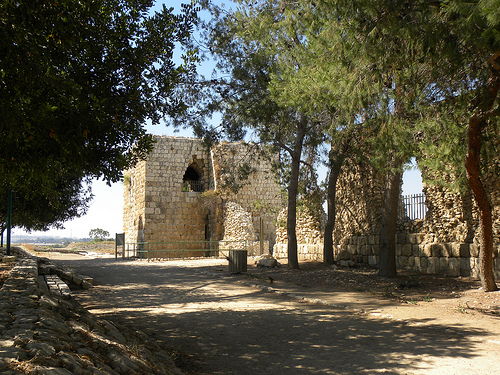
Ottoman
Fortress (Binar Bashi / Pinar Basha – “Head of the Springs”)
Built
1572–1574 CE by Sultan Selim II (or Selim I in some accounts), this
massive square fortified khan (caravanserai/hostel) was designed to
protect the Afek Pass and control traffic on the Via Maris. It reused
stones from earlier structures and is often mistakenly called
“Antipatris Fortress.”
Features massive walls, crenellated
battlements, corner towers (some climbable for views), and gates (west
and southeast).
The large central courtyard contains reconstructed
Middle and Late Bronze Age houses (c. 2000–1200 BCE) with typical
Canaanite layouts, stairs, and features.
It served as a military
outpost into the British Mandate; bullet scars from 1917 and 1948
battles are visible in places. Napoleon found it abandoned in 1799.
Bronze Age Remains (Early, Middle & Late Bronze Age, ~3300–1200 BCE)
One of the earliest walled cities in the region. Thick defensive walls
(up to 3.5 m wide), earthen ramparts, and multiple palaces were built
here due to the strategic springs and defensive swamps.
Egyptian
Governor’s Residence/Palace (Late Bronze Age, 15th–13th centuries BCE):
Excavated beneath the Ottoman courtyard; a large administrative complex
with thick walls, stairs, and evidence of Egyptian control (seals,
cuneiform tablets). Thutmose III and Amenhotep II campaigned through
Aphek.
Reconstructed Canaanite houses and palaces (I–V) inside/around
the fortress show domestic and elite architecture; early winepresses
were also found.
The site was a major Canaanite royal city mentioned
in Egyptian Execration Texts and Amarna letters.
Roman City of
Antipatris (1st century BCE–4th century CE)
Herod the Great rebuilt
and expanded the earlier settlement ~9 BCE, renaming it Antipatris in
honor of his father. It became a prosperous way-station with a grid
layout.
Cardo (main street): A well-preserved paved Roman road
(southeast–northwest orientation) with curbstones, drainage channels,
and cart-wheel grooves; lined with shops, houses, and public buildings.
A 300-m section is excavated east of the fortress.
Forum and villa
ruins: Public square and elite homes with columns and bases.
Odeon: A
small semi-circular roofed theater for music, poetry, and performances,
located near the Cardo.
The city was damaged in the Jewish Revolt (68
CE); Vespasian camped here. It declined after a 363 CE earthquake.
British Mandate Water Pumping Station (1930s)
A large concrete
complex east of the tel that pumped, filtered, chlorinated, and stored
water from the Yarkon springs for Jerusalem’s supply. Includes
sinking/filtering pools, chlorination buildings, and former soldier
residences/offices (now used by park staff). Visible bullet scars from
1948 fighting. It highlights the site’s continued strategic value into
the modern era.
Natural and Recreational Features
Yarkon
Springs and Artificial Lake: The second-largest water source in Israel;
the springs feed a scenic lake and water-lily ponds (with yellow water
lilies and rich aquatic life).
Squill Trail: A circular walking path
highlighting Roman, Ottoman, and British sites, planted with squill
bulbs (ancient field-boundary markers).
Paddling pools, picnic areas
under eucalyptus groves, sports fields, and accessible trails (concrete
paths, railings, benches). The park is family-friendly with toilets,
parking, and signage.
Historical Significance
Aphek has been inhabited for over 6,000
years:
Canaanite period — It was a major royal city with palaces and
administrative buildings (excavated finds include a 13th-century BCE
Egyptian governor’s residence).
Biblical era — Philistines camped
here before battling the Israelites and capturing the Ark of the
Covenant (1 Samuel 4).
Herodian/Roman period — Herod renamed it
Antipatris after his father; the New Testament mentions Paul being held
here overnight en route to Caesarea (Acts 23).
Later layers include
Byzantine, Crusader, Ottoman (the prominent fortress), and British
Mandate remnants (water pumping station).
The visible ruins today are
mostly Ottoman, but excavations reveal multi-layered history.
What to See and Do
Antipatris Fortress (Ottoman Pinar Bashi): The
standout feature—a large, well-preserved fortress on the tel (mound)
with great views over the coastal plain. Climb inside for panoramas and
imagine guarding the ancient pass. Short, easy walk from parking/picnic
areas.
Archaeological remains: Reconstructed Bronze Age houses, Roman
Cardo (street), forum fragments, and a small odeon (theater).
Nature
highlights: Artificial lake, paddling/wading pools (great for kids in
warm weather), water-lily pond (yellow blooms in summer), winter pool
with amphibians, and eucalyptus groves (planted to drain swamps).
Trails: Squill Trail (circular, marked by ancient boundary plants),
short paths around the fortress and ponds, and a connecting route to
Yarkon Springs area (note: separate entrances, gate often closed between
sections).
Other: British pumping station ruins, picnic/barbecue
areas, observation points, and wildlife (birds, fish, ducks).
The
site is compact enough for 1-3 hours but relaxing for longer with
picnics.
Practical Visiting Tips
Opening Hours (Yarkon
National Park – Tel Afek area): Summer (approx. April-Sept): Sun-Thu &
Sat 8:00-17:00 (last entry ~1 hour before close); Fri/holiday eves until
16:00. Winter: Closes 1 hour earlier. Confirm on the official Israel
Nature and Parks Authority site, as hours adjust seasonally. Entry
requires reservation in advance, especially weekends/holidays.
Entrance Fees (approximate, check current rates): Adult ~₪28-31, Child
~₪14-16, Student/Senior discounts. Free or reduced with annual
Matmon/Parks Card. Ticket often valid for both Tel Afek and Yarkon
Springs on the same day.
Reservations: Mandatory via the Parks
Authority website—select date/time slot. Show confirmation on arrival.
Getting There: By car—via Route 483 (Petah Tikva-Lod road), between
Kibbutz Givat Hashlosha and Einat. Plenty of parking. From Tel Aviv
~20-30 min. Public transport: Dan buses (e.g., 27, 7, 17, 93). Use Waze:
“Yarkon National Park – Tel Afek area (Antipatris)”.
Best Time to
Visit:
Spring (Mar-May): Green, blooming, mild weather—ideal for
trails.
Summer: Water activities (paddling), lily blooms, but hot—go
early morning or evening.
Fall/Winter: Fewer crowds, possible winter
pools/lakes, squill flowers; cooler for walking.
Avoid peak
weekends/holidays if you prefer quiet.
What to Bring and Wear
Comfortable walking shoes (some trails/fortress stairs).
Hat,
sunscreen, water (can get hot).
Bathing suit/water shoes for paddling
pools (summer).
Picnic food (facilities available; no major on-site
food).
Binoculars for birds/wildlife.
Map/app (pick up a map at
entrance).
Accessibility: Some paths (eucalyptus grove, pond
trail, fortress area) are accessible with concrete surfaces, railings,
and lookouts. Toilets and parking options available.
Dogs: Allowed if
leashed and muzzled.
Tips for a Great Visit
Combine with the
nearby Yarkon Springs area for water lilies and more nature (separate
but related site).
Picnic in the shaded eucalyptus grove—very
family-friendly.
Go with a guide for deeper history (private tours
available; self-guided with signs).
Respect rules: No jumping into
main water bodies; stick to paddling pools.
It’s a “green lung” near
urban areas—peaceful but can get busy on weekends.
Aphek (also known as Tel Aphek, Tel Afek, Tell Ras el-'Ain, or
Antipatris) is an ancient archaeological site in central Israel's Sharon
Plain, at the headwaters of the Yarkon River near modern Petah Tikva and
Rosh Ha'ayin. It occupies a strategic mound (roughly 400m x 300m)
controlling the Aphek Pass along the Via Maris—the major north-south
trade and military route linking Egypt to Mesopotamia and beyond. The
site's position, with abundant springs, marshes, and elevated terrain,
made it a natural fortress and crossroads for over 6,000 years of
continuous human occupation, from the Chalcolithic period through the
Ottoman era. It is best identified with the biblical Aphek (one of
several sites by that name) and the New Testament/Roman city of
Antipatris.
Today, it forms part of the Yarkon-Tel Afek National
Park, where visitors can see layered ruins including Canaanite palaces,
Roman streets, and an Ottoman fortress. Major excavations by Tel Aviv
University (led by Moshe Kochavi and Pirhiya Beck, 1972–1985, with
international collaboration including the University of Pennsylvania)
uncovered stratified layers revealing palaces, fortifications,
inscriptions, and trade goods that confirm its role as a political,
administrative, and cultural hub.
Chalcolithic and Early Bronze
Age (c. 4500–2700 BCE)
The earliest settlement dates to the end of
the Chalcolithic period (c. 4500–3150 BCE), with more substantial
occupation in Early Bronze Age I (c. 3000 BCE). Aphek was one of the
first walled cities in the region, featuring a defensive wall about 2.8
meters wide. The city flourished through much of the Early Bronze Age
but, like many Levantine sites, was largely abandoned toward the end of
the third millennium BCE (c. 2700–2000 BCE).
Middle and Late
Bronze Ages (c. 2000–1200 BCE): Canaanite City and Egyptian Rule
Aphek revived strongly in the Middle Bronze Age IIA (c. 2000–1750 BCE)
during Egypt's Twelfth Dynasty. Massive earthen ramparts, two
superimposed fortification systems, a royal palace, and a rich
intramural cemetery reflect its status as a major Canaanite center. It
appears in Egyptian Execration Texts as "Aphkm," ruled by a prince named
Ya’nakilu.
In the Late Bronze Age (c. 1550–1200 BCE), Egypt
established direct control after Thutmose III's campaigns (c. 1468 BCE).
Aphek became an administrative hub with an Egyptian governor's residence
(a large, multi-story "government house" of about 400 m² with thick
walls, courtyards, staircases, and storage). Excavations uncovered five
superimposed palaces, the earliest known large winepresses in the
southern Levant (two plastered treading floors and collection vats,
likely under Egyptian supervision for viticulture), and abundant
imported pottery from Cyprus and Mycenae.
Remarkable finds from the
acropolis (under the later Ottoman fortress) include cuneiform tablets
and fragments in Akkadian, Sumerian, Canaanite, Hittite, and
Egyptian—evidence of a local scribal school and Aphek's role as an
international crossroads. These include lexical lists
(Sumerian-Akkadian-Canaanite trilingual), administrative records, a
Hittite bulla, and an Egyptian foundation deposit with Ramesses II's
cartouche. The city was destroyed by fire in the late 13th century BCE,
possibly amid the collapse of Egyptian control. Philistine pottery
appears in 12th-century layers.
Iron Age and Biblical Period (c.
1200–586 BCE)
Aphek transitioned into the Iron Age. It is listed
among Canaanite cities whose kings Joshua defeated (Joshua 12:18), and
it appears in the tribal allotments (Joshua 19:30; Judges 1:31, though
some references may link to other Apheks). By the 12th–11th centuries
BCE, it served as a Philistine base. The Philistines camped here before
battling the Israelites at nearby Ebenezer (c. 1050 BCE), capturing the
Ark of the Covenant (1 Samuel 4:1–11). A later Philistine muster at
Aphek preceded the battle at Mount Gilboa where King Saul died (1 Samuel
29:1).
Under David and Solomon, the area came under Israelite control
and later formed part of the Northern Kingdom. A Proto-Canaanite
abecedary (one of the earliest alphabetic inscriptions) was found in a
related 12th–11th century village at nearby Izbet Sartah. In the 9th–8th
centuries BCE, Aphek expanded; a late Iron IIA destruction layer may tie
to Aramean campaigns. Assyrians under Tiglath-Pileser III, Shalmaneser
V, Sargon II, and later Esarhaddon (671 BCE) conquered and exiled
populations here. Babylonian forces passed through en route to Judah's
final destruction (587 BCE).
Hellenistic to Early Roman Period
(4th century BCE–1st century CE)
After Alexander the Great, the site
was resettled and Hellenized as Pegae ("the springs"). It served as a
border town under Hasmonean rule (conquered by John Hyrcanus I and
fortified by Alexander Jannaeus). Pompey renamed the area Arethusa in 63
BCE.
In 9 BCE, Herod the Great rebuilt and expanded the town as
Antipatris, naming it after his father Antipater. Josephus described it
as a beautiful city in a well-watered plain. It featured a paved cardo
(main street with shops), forum, small odeon (roofed theater), mosaics,
villas, and public buildings—serving as a key waypoint on the
Jerusalem–Caesarea road.
In the New Testament, Roman soldiers
escorted the Apostle Paul overnight to Antipatris en route from
Jerusalem to Caesarea for trial before Governor Felix (Acts 23:31–32).
During the First Jewish Revolt (66–70 CE), the site saw action:
Vespasian camped nearby at Migdal Aphek, and Cestius Gallus's army was
routed as far as Antipatris.
Later Periods (2nd–20th centuries
CE)
The Roman city peaked in the 2nd–4th centuries CE but suffered
major damage in the 363 CE earthquake and was largely abandoned after
another quake c. 419 CE. It became a Christian bishopric (suffragan of
Caesarea) in Byzantine times. In 750 CE, Abbasid forces massacred
Umayyads here (known as Abu Futrus).
During the Crusader period (12th
century), the area featured a fortress (Recordane or Mirabel/Turron de
Surdi Fontes) guarding the pilgrimage route; pottery and structures
survive. The Ottoman Empire built a large rectangular fortress (Khan or
Binar Bashi, "head of the springs") in 1571–1574 under Selim II/Suleiman
the Magnificent to protect the Cairo–Damascus highway. This
well-preserved structure with corner towers dominates the visible ruins
today.
Summary and Legacy
Aphek's layers encapsulate the rise
and fall of Canaanite city-states, Egyptian imperialism,
Philistine-Israelite conflicts, Israelite kingdoms, Hellenistic
kingdoms, Herodian-Roman administration, and later empires. Its
strategic location ensured repeated rebuilding, while destruction layers
(fire in LB, Assyrian/Babylonian campaigns, earthquakes) mark broader
regional upheavals. Excavated artifacts—palaces, winepresses,
multilingual inscriptions, alphabetic texts, and Roman
infrastructure—illuminate trade, literacy, and daily life across
millennia.
Location and Regional Context
Aphek lies in the coastal hinterland
of central Israel, approximately 12 km east of Tel Aviv and roughly
20–25 km northwest of Jerusalem. It sits near modern Rosh Ha’ayin and
Petah Tikva, within the Yarkon National Park (also encompassing parts of
the Ein Afek Nature Reserve). Precise coordinates are approximately
32.105°N 34.930°E (or very close to 32°05′N 34°53′E).
The site
occupies the southern end of the Sharon Plain, a flat, fertile coastal
lowland stretching about 90 km north–south (from the Taninim Stream to
the Yarkon River) and roughly 15 km wide. This plain is part of Israel’s
broader coastal plain, characterized by parallel kurkar (fossilized
sandstone) ridges that historically created drainage issues and
extensive wetlands. To the east lie the foothills and lower slopes of
the Samaria Hills (part of the central highlands), while the west opens
toward the Mediterranean coastal lowlands. Aphek is positioned at the
critical transition zone between these hilly uplands and the alluvial
plain.
Topography of the Tel
The tel itself is one of the
largest mounds in ancient Israel, covering approximately 30 acres (about
12 hectares or 120 dunams). It rises prominently 15 meters above the
surrounding plain as a raised plateau. The northern face has a steep
slope, while the eastern, southern, and western sides have gentler,
less-defined contours. This elevation gives the site commanding views
over the coastal plain to the north and west.
The mound sits at an
elevation of roughly 17–20 meters above sea level, directly overlooking
the flat Sharon Plain and the narrow corridor known as the Aphek Pass
(or Yarkon Pass).
Hydrology and Water Resources
Aphek’s most
defining geographical feature is its location at the headwaters of the
Yarkon River (Nahal Yarkon), Israel’s largest perennial stream in the
central region. The site is built atop and immediately adjacent to the
Rosh Ha’ayin Springs (literally “head of the springs”), a cluster of
strong, perennial freshwater sources fed by the Yarkon-Taninim aquifer.
These springs historically produced an abundant flow, forming the
river’s origin and creating a lush, water-rich oasis amid the coastal
plain.
The Yarkon River flows westward from Aphek for approximately
27–30 km before emptying into the Mediterranean Sea near Tel Aviv. In
antiquity (and until modern drainage projects), the river and its
associated wetlands created extensive marshes and swampy ground
immediately west and southwest of the tel, forming a natural barrier to
movement. The springs have been a reliable water source for millennia,
supporting settlement, agriculture, and even modern infrastructure
(e.g., the British Mandate-era pumping station that supplied Jerusalem).
Strategic Geography and the Via Maris
Aphek’s geography made it
one of the most strategically vital locations in the ancient Near East.
It guarded the narrow Aphek Pass—a roughly 2 km-wide bottleneck on the
ancient Via Maris (the “Way of the Sea” or International Coastal
Highway). This major north–south trade and military route linked Egypt
in the south with Syria, Mesopotamia, and Anatolia in the north.
East: The Samarian Hills and their foothills blocked easy passage.
West: The Yarkon River and its marshes/swamps rendered large sections of
the coastal plain impassable for armies or caravans without major
engineering.
Result: All traffic was funneled through the narrow
corridor right past the foot of the tel.
South of Aphek, two
coastal routes converged before continuing northward toward Mount
Carmel. This chokepoint gave Aphek control over trade, taxation, and
military movements for thousands of years, from Canaanite times through
Egyptian, Philistine, Israelite, Hellenistic, Roman, Crusader, and
Ottoman periods.
Climate, Soils, and Natural Environment
Aphek
experiences a classic Mediterranean climate (Köppen Csa):
Hot, humid
summers (June–September: daytime highs often 28–32°C or higher, with
high humidity near the river).
Mild, wet winters (December–February:
daytime highs 15–20°C, lows 8–12°C).
Annual rainfall averages around
530–600 mm, almost entirely between October and April.
The
perennial springs create a localized lush micro-environment with
year-round greenery, contrasting with the drier surrounding plain in
summer. Soils in the Sharon Plain are primarily fertile alluvial
deposits mixed with hamra (red sandy soils) and kurkar ridges,
supporting intensive agriculture (historically grains, orchards, and
citrus). The area around the springs historically featured wetlands,
reeds, and water-loving vegetation; today the national park preserves
pools (including a notable water-lily pool), restored riparian habitats,
and mature trees.
Modern Geographical Context
Today, Aphek is
a protected archaeological and natural site within the densely populated
central district of Israel. The Ottoman-period fortress (built ~1571 CE
by Sultan Selim I, known as Pinar Bashi or similar) still crowns the
tel. The surrounding park offers trails, panoramic views of the Sharon
Plain, and access to the Yarkon springs and river. While the broader
region is urbanized, the park functions as a green oasis with
significant biodiversity and recreational value. Historical drainage has
reduced the marshes, but the springs remain a key hydrological feature.