Location: 12 km (7.5 mi) South of Jerusalem Map
Herodium (also known as Herodion or the Herodium) is one of the most remarkable archaeological sites in the Judean Desert, located approximately 12 km (7.5 miles) southeast of Jerusalem and 5 km southeast of Bethlehem, in what is today the West Bank (under Israeli administration as part of Herodion National Park). At an elevation of 758 meters (2,487 ft), it consists of a dramatic, artificially enhanced conical hill crowned by a fortified palace-fortress (Upper Herodium) and a sprawling lower complex of palaces, gardens, pools, and administrative buildings (Lower Herodium). Built by King Herod the Great (r. 37–4 BCE), it served as a luxurious desert retreat, administrative center, fortress, and—most famously—his intended and actual burial place. The site exemplifies Herod’s engineering genius, paranoia, and self-aggrandizement, blending Roman, Hellenistic, and local architectural influences.
Origins and Construction (c. 23–15 BCE)
Herod chose the site
deliberately. According to the 1st-century historian Flavius Josephus
(in Jewish War 1.419–420), it commemorated a pivotal victory in 40 BCE.
While fleeing Parthian-backed Hasmonean forces under Antigonus II
Mattathias toward Masada, Herod won a key battle here. He transformed
the natural hill into a “breast-shaped mound” (as Josephus described it)
by piling earth and rubble around the summit to create an artificial
cone, making the entire mountain a monumental tumulus visible for miles.
Construction began around 23–15 BCE (some sources cite c. 28 BCE or the
third decade BCE) as part of Herod’s massive building program, which
included the Second Temple in Jerusalem, Masada, and Caesarea Maritima.
The project was enormous: the upper palace-fortress sat atop a 60-ris
(about 11–12 km) distance from Jerusalem, named “Herodium” after the
king himself—the only site he named for himself. It combined defensive
strength with opulent living quarters, serving as a personal memorial,
burial monument, and toparchy (district) capital.
Key features of
the complex:
Upper Herodium (the summit fortress-palace): A circular
structure (about 60–65 m in diameter) with double concentric walls and
four massive towers (three semi-circular ~16 m diameter; one eastern
round tower ~18–20 m diameter, likely Herod’s private quarters). Inside:
luxurious residential suites, a large peristyle courtyard, banquet halls
(triclinia), a Roman-style bathhouse (with caldarium, tepidarium, and
frigidarium featuring hypocaust heating and mosaics), storage, and
cisterns. Frescoes and mosaics adorned the walls and floors; some
painters may have been imported from Rome.
Lower Herodium (at the
base): A vast pleasure palace and administrative center covering ~40
acres total. It included a huge Great Palace (130 m long), extensive
formal gardens, an enormous plastered pool (one of the largest in the
ancient world, with a possible island pavilion for swimming or
banquets), courtyards, and service buildings. An aqueduct brought water
from Solomon’s Pools (near Bethlehem) at great expense. Halfway up the
northeastern slope stood a 450–650-seat Roman theater with a royal
loggia (box) decorated with elaborate stucco and frescoes depicting
Italian and Nile landscapes—possibly built for a visit by Marcus Agrippa
in 15 BCE.
Engineering feats: The artificial mound required moving
vast quantities of earth; water systems included large cisterns and
channels. The site dominated the surrounding desert landscape as both a
symbol of power and a strategic stronghold.
Herod’s motivations
were multifaceted: security (desert fortresses like this and Masada
protected against unrest), propaganda (a visible monument to his
victories and Roman alliances), and personal legacy (a
self-commemorative burial site away from Jerusalem, where he was
unpopular among many Jews).
Herod’s Death and Burial (4 BCE)
Herod died in Jericho in early 4 BCE at age ~70, reportedly from a
gruesome illness. Per Josephus, his body was carried in a grand funeral
procession to Herodium for burial—the climax of his life’s work. In his
final years, he added a monumental mausoleum on the northeastern slope
(facing Jerusalem), just above the lower palace and near the theater.
This ~25–30 m high structure featured a square podium, circular tholos
(dome-like element) with Ionic columns, and a conical roof—echoing
Nabatean and Jerusalem tombs.
The tomb was discovered in 2007 by
archaeologist Ehud Netzer (Hebrew University) after 35 years of
excavations. It had been largely destroyed in antiquity (likely by
rebels), but foundations, stairways, and fragments of three sarcophagi
were found: two plain white limestone and one ornate red limestone with
carved rosettes (possibly Herod’s). A reconstructed model (1:7 scale)
and artifacts, including a stone urn, are displayed at the Israel
Museum.
Post-Herod History (4 BCE–71 CE)
After Herod’s death,
the site passed to his son Archelaus (ethnarch of Judea, 4 BCE–6 CE).
When Archelaus was deposed, Roman governors (prefects/procurators)
administered it. A copper-alloy ring inscribed “of Pilate” (possibly
belonging to Pontius Pilate or an official) was found in excavations,
suggesting administrative use in the early 1st century CE.
The
Jewish Revolts
First Jewish–Roman War (66–73 CE): Jewish rebels
(Zealots/Sicarii) seized Herodium as a stronghold. They repurposed a
large triclinium (dining hall) in the upper palace into a
synagogue—adding benches along the walls, an eastern entrance, and a
nearby mikveh (ritual bath). They held out until 71 CE, when Roman
legate Sextus Lucilius Bassus captured it after the fall of Jerusalem.
Rebels likely damaged or destroyed the mausoleum in defiance.
Bar
Kokhba Revolt (132–135/136 CE): Herodium served as a major rebel
headquarters under commander Yeshua ben Galgula. Extensive tunnel
systems were dug beneath the hill for refuge and surprise attacks (some
still accessible today). Coins, documents (linked to the Muraba’at
Caves), and burned debris confirm intense use. The site fell to the
Romans again, after which it was largely abandoned.
Byzantine and
Early Islamic Periods (4th–9th centuries CE)
In the Byzantine era,
Lower Herodium was rebuilt as a large Christian village with at least
three churches. A small monastery and chapel occupied the ruined upper
palace. The settlement persisted until the 9th century CE before
declining into ruins.
Rediscovery and Modern Archaeology
The
site was identified in the 19th century by American scholar Edward
Robinson (1838), confirmed by later surveys. Systematic excavations
began in 1962–1967 by Franciscan archaeologists Virgilio Corbo and
Stanislao Loffreda (upper citadel). From 1972 until his death in 2010,
Ehud Netzer led major Hebrew University campaigns, uncovering Lower
Herodium, the theater, and—dramatically—the tomb in 2007. Ongoing
research continues under the Herodium Expedition.
Today, Herodion
National Park is a popular tourist site managed by the Israel Nature and
Parks Authority. Visitors can explore the ruins, tunnels, and panoramic
views. Debates persist (e.g., some question if the tomb is definitively
Herod’s due to its relative modesty), but the identification is widely
accepted. The site remains a powerful testament to Herod’s architectural
ambition and a key witness to two Jewish revolts against Rome.
Herodium (also known as Herodion or Har Hordos) is one of the most
ambitious and innovative architectural complexes built by King Herod the
Great (r. 37–4 BCE). Constructed between approximately 23 and 15 BCE in
the Judean Desert, about 12 km south of Jerusalem and 5 km southeast of
Bethlehem, it served as a fortified palace, administrative center,
recreational resort, and intended mausoleum for Herod himself. Josephus
(Jewish War 1.419–421) describes Herod creating a “breast-shaped mound”
named after himself, crowned with circular towers enclosing a lavish
palace, with a steep ascent of 200 polished stone steps. The site
uniquely combines Hellenistic-Roman luxury with military engineering in
a desert environment, reflecting Herod’s role as a Roman client king who
blended Roman technology, Hellenistic aesthetics, and local Judean
building traditions.
The complex is divided into two main parts: the
Upper Fortress-Palace on an artificially heightened conical hill (the
acropolis) and the Lower Herodium at its base, covering a vast area (the
entire site spans about 40 acres). A monumental processional way and
theater linked them, with sophisticated water systems enabling gardens
and baths in an arid landscape.
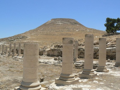
The Artificial Mountain
Herod
transformed a natural hill (originally ~758 m above sea level) into a
dramatic, truncated-cone-shaped tumulus by piling massive amounts of
earth and rubble around the base, creating a breast-like or conical
silhouette visible for miles across the Judean Desert to the Dead Sea.
This artificial mound not only elevated the palace for defense and
symbolism but also protected the lower walls of the upper structure. A
grand staircase of ~200 hewn stone steps provided the main approach from
the north/northeast. The engineering feat required enormous labor
(slaves and paid workers) and precise grading to achieve the symmetrical
form while maintaining stability.
Upper Fortress-Palace (Summit
Citadel)
The upper complex is a circular fortified palace ~60–63 m
(about 200 feet) in diameter—the only known circular palace-fortress of
its scale from the period. It features double concentric walls (~2.5 m
thick and ~2.5 m apart, originally rising ~30 m or 100 feet high,
equivalent to 7 stories: 5 above ground and 2 vaulted subterranean
levels for storage and service). The annular space between the walls
contained living quarters, apartments, storage rooms, and corridors.
Four massive towers projected from or integrated with the walls
(aligned roughly with cardinal directions):
Three semi-circular
towers (~14–16 m / 45 feet in diameter) for living spaces and storage.
One full circular eastern tower (the largest, ~18 m / 55–59 feet in
diameter on a solid stone base), likely Herod’s private residence with
the most luxurious rooms.
The towers originally reached several
stories high (possibly up to 7 for the largest), though upper portions
are lost. Inside the circle was a large central courtyard (peristyle)
surrounded on three sides by colonnades with Corinthian capitals
(acanthus leaves and volutes). This open space included gardens and
served as a hub for the residential and entertainment areas.
Key
interior spaces included:
Banquet hall (triclinium): A large U-shaped
dining room with adjoining chambers, later converted into a synagogue by
Jewish rebels (66–73 CE) with added benches and a mikveh.
Roman-style
bathhouse: Complete with caldarium (hot room with hypocaust underfloor
heating and vaulted ceilings), tepidarium (warm room with mosaics and
frescoes), frigidarium (cold plunge pool), and a surviving dome. Walls
featured painted stucco; floors had intricate mosaics.
Royal
apartments and reception halls: Lavishly decorated with colorful mosaic
floors and elaborate frescoes (including marble imitation, striped
patterns in green/black/auburn, and imaginary landscapes or
architectural illusions). Some rooms had pilastered walls and vaulted
ceilings.
The design is geometrically precise: the circular outer
plan unifies with the internal layout, creating a self-contained,
defensible luxury residence. Later occupations (First Jewish Revolt, Bar
Kokhba Revolt) added tunnels and modifications, but the core remains
Herodian.
Lower Herodium (Base Complex)
At the foot of the
mound (primarily north/northwest), Herod built an expansive palatial
resort and administrative center for entertaining guests, recreation,
and governance (as the capital of a toparchy). Key features:
Great Pool Complex: A massive rectangular plastered pool (~70 × 45 × 3
m, holding ~10,000 m³ of water) with a central island pavilion (possibly
a tholos). Surrounded by formal gardens, colonnades, and promenades.
Water was supplied via aqueducts from Solomon’s Pools (near
Hebron/Artas) and local cisterns— a remarkable feat in the desert.
Additional bathhouse and residential/administrative buildings:
Roman-style facilities, guest quarters, stables, and storage.
Roman
Theater: Halfway up the northeastern slope (~450–650 seats), with a
luxurious private loggia/royal box for Herod and guests. The chamber
featured exceptionally preserved secco frescoes depicting Italian
landscapes, the Nile River, and scenic views—likely painted by Italian
artists. A monumental staircase and entranceway connected it to the
upper complex.
The lower area also included a small town-like
settlement with gardens and structures for Herod’s funeral procession.
Herod’s Mausoleum (Northeastern Slope)
Discovered in 2007 by Ehud
Netzer’s team on the northeastern slope (near the theater), this is one
of the most impressive Herodian funerary monuments. It was deliberately
dismantled in antiquity (likely by rebels ~66 CE). The reconstructed
structure was a free-standing, three-storied monument ~25 m (up to ~34 m
in some estimates) high:
High podium (square base ~9.95 × 9.95 m,
with multiple courses, base moldings including cyma recta, plinth,
fillet, ovolo, and cavetto; plain dado).
Square lower story with
Doric pilasters and frieze (guttae, rosettes).
Circular tholos (upper
pavilion) encircled by 18 monolithic Ionic columns (Attic bases,
elaborate Ionic capitals with eggs/darts/palmettes; curved outer wall
with pilasters inside).
Concave-conical roof (scale-patterned, with
modillion cornices featuring egg-and-dart and S-curved modillions)
crowned by six urns around the edge and a central urn on a Corinthian
capital (acanthus leaves, rosettes).
Materials included finely
dressed limestone ashlars with anathyrosis (precise edge dressing for
tight joints). Fragments show mixed orders (Doric below, Ionic columns,
Corinthian crown), eclectic Roman-Hellenistic influences (comparable to
the Mausoleum at Halicarnassus, Lysicrates Monument, or Petra tombs),
and local adaptations. Three ornate sarcophagi fragments were found
nearby (one red stone with rosettes possibly Herod’s). A 1:7 scale model
is displayed on-site.
Engineering, Decoration, and Significance
Water System: Extensive cisterns, aqueducts, and channels brought water
from distant sources to fill pools, baths, and gardens—critical for
luxury in the desert.
Materials and Craftsmanship: Local limestone
ashlars, imported influences in decoration; high-quality carving (e.g.,
monolithic columns, detailed moldings).
Style: Roman engineering
(baths, theater, hypocaust) + Hellenistic orders
(Corinthian/Ionic/Doric) + Herodian innovation (circular fortress-palace
hybrid, artificial mound). Frescoes and mosaics evoked Roman villas but
respected local sensibilities.
Legacy: Herodium exemplifies Herod’s
building mania (alongside Masada, Caesarea, and the Temple Mount). It
functioned until the Roman destruction in 71 CE, with later reuse.
Excavations (primarily by Ehud Netzer 1972–2010, building on earlier
work) continue to reveal details; only the upper fortress is fully open
to visitors today.
Herodium (also known as Herodion or Jabal al-Fureidis, "Mountain of
Paradise") is a striking archaeological and geographical landmark in the
Judean Desert region of the West Bank (Bethlehem Governorate),
Israel/Palestine. It sits at coordinates 31°39′57″N 35°14′29″E,
approximately 12 km (7.5 mi) south of Jerusalem and 5 km (3.1 mi)
southeast of Bethlehem, nestled between Palestinian villages such as
Beit Ta'mir and Za'atara to the east and Jannatah, Tekoa, and Nokdim to
the west.
The site lies on the eastern edge of the Judean Hills,
where the landscape transitions sharply into the arid Judean Desert
(also called the Judean Wilderness), which slopes dramatically southeast
toward the Dead Sea. This positioning places it in a classic rain-shadow
zone: Mediterranean moisture from the west is blocked by the Judean
highlands, resulting in a semi-arid to arid climate with hot, dry
summers (often exceeding 30–35°C/86–95°F), mild winters, and very low
annual rainfall (typically under 300–400 mm, much of it in erratic
winter storms).
Topography and Engineered Landscape
Herodium’s
most distinctive geographical feature is its artificial truncated-cone
(or breast-shaped) hill, rising to an elevation of 758 m (2,487 ft)
above sea level—the highest peak in the Judean Desert. What appears as a
natural volcanic cone is largely man-made: Herod the Great’s engineers
(circa 23–15 BCE) took an existing natural hill and dramatically
reshaped it by hauling vast quantities of earth and debris (primarily
from a hill immediately to the north) to create a steep, symmetrical
mound. The summit was flattened into a circular platform roughly 200
feet in diameter, encircled by massive concentric walls and towers,
while the lower slopes were scarped at about 35° angles for defense and
visual drama.
This engineering feat transformed the local topography,
making the site a dominant landmark visible from Jerusalem on clear
days. The artificial mound dominates the surrounding desert hills and
wadis (dry riverbeds), creating a commanding 360° panorama that includes
Bethlehem and Jerusalem to the north/northwest, the rolling Judean
Desert hills, the Dead Sea to the east/southeast, and the distant
mountains of Moab (in modern Jordan) beyond.
Aerial views highlight
the cone-shaped form, the flattened summit ruins of the upper
palace-fortress, and the lower city complex (with pools, gardens, and
administrative buildings) at the base.
Geological Context
Geologically, Mount Herodium sits on the northwestern flank of the
Bani-Na’im Anticline (a broad dome structure in the Hebron geological
sheet). The underlying bedrock belongs to the Judea Group and Mount
Scopus Group:
Turonian-age limestones (Shivta and Nezer Formations,
part of the B’ina Fm) — hard, massive meleke (white, bioclastic) and
mizzi hilu (gray, finely crystalline) types — provided the primary
building stones quarried locally to the west and south.
Overlying
Senonian chalk (Menuha Formation, Santonian–lower Campanian, up to ~50 m
thick) — softer, chalky layers that form the “ring” around the base.
Campanian chert (Mishash Formation) — massive layers visible in the
upper sections and tunnels.
Detailed mapping reveals a dome-like
structure with gentle dips (5–10°) away from the site, plus evidence of
a minor normal fault causing ~20–45 m of vertical displacement over
short distances. This geology not only supplied durable stone but also
influenced construction: the mound’s fill material included local
debris, while tunnels (later expanded during the Bar Kokhba Revolt) were
carved into the softer chalk and chert layers.
Hydrology and
Water Management
In this water-scarce desert environment, hydrology
was a critical geographical adaptation. There are no natural springs on
the hill itself. Instead, Herod’s engineers built an aqueduct system
(part of the broader Jerusalem aqueduct network) channeling water ~4–6
km from springs and Solomon’s Pools near Artas/Bethlehem (in the Artas
Valley). Water flowed by gravity to large cisterns, pools, and gardens
at Lower Herodium, and was lifted or stored for the upper palace. The
site features multiple plastered cisterns and reservoirs carved into the
bedrock.
A schematic of the underground water and tunnel systems
(including Herodian cisterns and later rebel modifications) illustrates
how the natural geology was exploited for storage.
Ecology and
Regional Setting
Vegetation is typical of the Judean Desert: sparse,
drought-resistant scrub (including thorny shrubs, grasses, and
occasional acacia or pistachio trees), with greener patches in wadis or
irrigated areas. Nearby hills support some olive groves and terraced
fields, but the immediate surroundings emphasize barren, rocky slopes
and dramatic desert vistas. Fauna includes ibex, hyrax, birds of prey,
and desert reptiles, though the site’s primary ecological note is its
engineered “oasis” effect—Herod created gardens and pools amid the
aridity.
The broader Judean Desert context features deeply incised
wadis, limestone cliffs, and a steep drop (over 1,000 m in places)
toward the Dead Sea rift valley, creating one of the most visually stark
and historically significant desert landscapes in the Levant.
Getting There
By Car (Recommended): Use Waze or GPS for "Herodium
Park." From Jerusalem, head toward Har Homa, take Road 398 toward
Tekoa-Nokdim, and follow signs (turn left ~2 km before Tekoa junction).
From the center of the country (e.g., via HaEla Junction), routes
involve Roads 375/60/3157/356. Free parking is available at the base.
Public Transport: Limited options. Bus 366 from Jerusalem's central bus
station goes toward the area, but a taxi or arranged pickup is easier
for most visitors.
Tours: Many organized day trips or half-day tours
from Jerusalem include Herodium, often combined with Bethlehem or other
Herod sites. Private guides or English tours can be arranged on-site or
in advance. Hebrew guided tours run Fridays/Saturdays at noon.
Note on Location: The site lies in a contested area (Judea and
Samaria/West Bank). It is generally safe for tourists with standard
precautions, but check current travel advisories, especially if driving
a rental car.
Opening Hours and Fees (as of recent data)
Summer (April–September): Sun–Thu & Sat: 8:00–17:00; Fri/holiday eves:
8:00–16:00.
Winter (October–March): Sun–Thu & Sat: 8:00–16:00;
Fri/holiday eves: 8:00–15:00 (earlier on some eves).
Entrance closes
1 hour before closing time. Closed on Yom Kippur and other major
holidays.
Fees (approximate, in NIS; confirm on-site or via
Israel Nature and Parks Authority):
Adult: ~29–31
Child: ~15–16
Student/Senior (Israeli): discounted
Groups: reduced rates. Israel
Pass may offer benefits.
A small visitor center at the base has a
model, short movie (with subtitles), souvenir shop, and kiosk.
What to See and Do (1.5–3 Hours Visit)
The Climb to the Summit: A
moderate-to-strenuous ascent via paths and stairs up the engineered hill
(hundreds of steps). Rewards include the palace ruins with circular
walls, towers, living quarters, and stunning 360° views.
Upper
Palace-Fortress: Remains of luxurious halls, frescoes, and
fortifications. Herod created a "mountain" by reshaping the hill for
both defense and monumentality.
Herod’s Tomb/Mausoleum: Discovered in
2007 by Ehud Netzer (after decades of searching). See the reconstructed
sarcophagus area (original fragments in the Israel Museum) and the
theater below, used for the funeral procession.
Lower Herodium:
Roman-style bathhouse (with mosaics/frescoes), enormous pool/gardens,
administrative buildings, and a 300-seat personal theater.
Tunnels
and Synagogue: Explore rebel-dug escape/water tunnels from the Bar
Kokhba Revolt (132–135 CE). A dining room was converted to a synagogue
during the Great Revolt.
Byzantine Churches: Later mosaic floors from
monastic use.
Visitor Tip: Follow the marked trails clockwise or
use the park map/brochure for a logical flow from base to summit and
back. Audio guides or apps may enhance the experience.
In-Depth
Visiting Tips
Best Time to Visit:
Spring (March–May) or Autumn
(Sept–Nov): Mild temperatures, good visibility, fewer extremes.
Early
morning: Avoid midday heat (especially in summer), beat any small
crowds, and enjoy softer light for photos. Sunsets can be dramatic but
check closing times.
Weekdays are quieter than weekends/holidays.
What to Wear/Bring:
Sturdy, closed-toe walking shoes (loose
gravel, stairs, uneven paths).
Hat, sunscreen, sunglasses — exposed
site with little shade.
Plenty of water (no reliable sources on-site;
buy at the kiosk).
Light layers (desert can cool quickly or get
windy).
Binoculars for distant views.
Physical Considerations:
Significant climbing involved; not wheelchair-accessible. Those with
mobility issues can enjoy the base areas and lower theater but may miss
the summit. Take breaks and go at your own pace.
Safety and
Practicalities:
Standard national park rules: No dogs, stay on paths.
Heat/sun exposure is the main risk — hydrate and rest in shade.
Respect archaeology; do not climb on ruins.
Security: Follow local
guidance; the area has Israeli park management.
Enhance Your
Visit:
Combine with nearby sites like Bethlehem, Tekoa, or a Judean
Desert drive.
Read up on Herod beforehand (ruthless yet brilliant
builder) or watch a short documentary for context.
Photography is
excellent — capture the conical shape from below and views from above.