Location: Northwest Israel
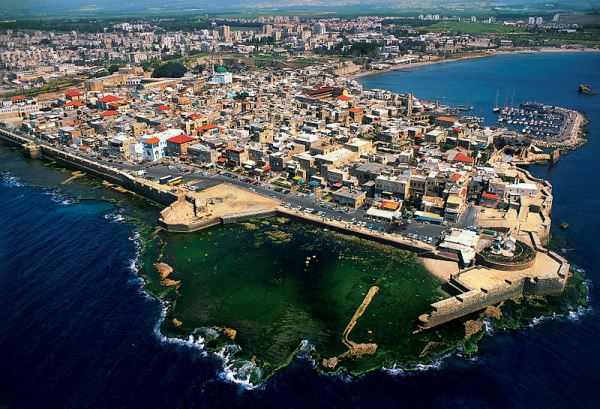
Akko (Greek: Ἄκη, Hebrew: עכו) is a port city in western Galilee
on the Mediterranean coast in northern Israel. Akko, sometimes also
called Acre, located on a peninsula at the northern end of the Bay
of Haifa, was the most important port in Palestine until the 19th
century.
The earliest traces of settlement on Tel Akko,
Arabic Tell el-Fukhar, date from the Bronze Age (3rd century BC).
The city-state of Akko was a vassal state of Egypt, as evidenced by
numerous mentions in city lists on Egyptian papyri. In the first
millennium BC, the city came under the influence of Tyre, a
Phoenician foundation in what is now Lebanon. In the fifth century
BC, the city came under Persian rule.
In the fourth century
BC, the region was conquered by the troops of Alexander the Great,
and his successors brought Akko under the rule of the Ptolemies;
around the year 260, the city was given the name Ptolemais in honor
of Ptolemy I. Around 200 BC, the city was conquered by Antiochus III
and from then on was in the hands of the Seleucids, who were based
in Syria. In 64 BC, the city came into Roman hands and was
incorporated into the province of Syria - from then on, it remained
dominated by Roman and later Byzantine culture for centuries. After
the victory of the Muslim Arabs over the Byzantines, the city
remained under Muslim rule until 1104.
As the only safe
harbor on the Mediterranean coast that could be used all year round,
Akko quickly became the target of the Crusaders. It was only after a
long siege that King Baldwin I, ruler of the Kingdom of Jerusalem,
managed to capture the city in 1104. St. Jean d'Acre became the most
important port of the Crusader state and, thanks to its importance
as a trading hub, the second most important city in the Levant by
1130 with around 25,000 inhabitants. In 1187, the Ayyubid Sultan
Saladin managed to capture Akko. After a three-year siege in
1189/91, the city fell back to the Crusaders under Richard the
Lionheart. After the fall of Jerusalem, it became the capital of the
Crusader Empire. The city flourished thanks to trade between the
West and the Orient and various lords ruled the city districts.
It was not until 1291, after a long siege by the Egyptian Mamluk
Sultan al-Malik, that Akko, the last stronghold of the Crusaders in
the Levant, fell. In order not to be recaptured and used again, the
buildings were largely reduced to rubble and ashes. The seat of the
province was moved to Safed, and in 1517 the city was incorporated
into the Ottoman Empire. Sheikh Zahir al-Umar, who had built an
empire in Galilee, renovated the city and strengthened the
fortifications using the old ruins. After a siege lasting over 61
days, Napoleon failed to take Acre; cannons left behind by his
troops still bear witness to the attempt by the French expeditionary
corps.
The city, which had been opened up in 1913 with a
branch of the Hejaz Railway from Haifa, was conquered by the British
in 1918 and incorporated into the Mandate of Palestine in 1922; of
the 6,420 inhabitants, 4,883 were Muslims, 1,344 Christians, 102
Baha'is, 78 Jews and 13 Druze. In the ruins of the Crusader
fortress, the Mandatory power set up a prison in which numerous
Jewish and Arab rebels were imprisoned. In a spectacular operation
in 1947, numerous Jewish activists were freed by the Irgun.
During the War of Independence, the city was captured by the Haganah
on May 17, 1948. Three quarters of the Arab population of 17,395
residents left the city, and Moroccan and later Russian Jews settled
in Akko, so that today 30,000 of the approximately 46,000 residents
are of Jewish descent - living together with the Arab residents,
mainly in the old town area, has been an example of problem-free
coexistence in recent years. In 2001, the old town was added to the
UNESCO World Heritage List.
The wall system of Acre was built in three stages between 1750 and
1840. The first wall was built in 1750-1751. It was a thin wall (a
meter wide) 10-13 meters high. The wall surrounded the whole of Acre
from the land and sea side, but it did not protect against
undermining and ladders. There were two gates in the wall: on the
north-west and south-east sides.
The construction of new
walls was carried out during the time of Al-Jazzar. At this time,
new walls were built and the old ones were strengthened. In
addition, a canal was dug between the old and new walls. The city
withstood the siege of Napoleon, but even after that Al-Jazzar
continued to strengthen the old and build new walls. The
construction was completed in 1801. Basically, these are today's
walls of Acre. 9 new towers were built. A deep and very wide moat
filled with water was dug. New cannons were installed on all the
walls and towers, which completely covered all approaches to Acre
from the sea and land. Access to the walls was allowed only to
military personnel or civilians with special passes. After the death
of Al-Jazzar in 1804, Suleiman Pasha began to strengthen the
northern and western walls (from the land side). He built walls
opposite the stairs and made small loopholes in them, as they do in
fortresses, and began to build an outer moat. Suleiman Pasha also
built walls from the sea side, using huge blocks from the Crusader
buildings for construction. In 1840, during the explosion of an
armory, a large part of the inner and outer wall from the sea side
was damaged. During the Turkish rule, many walls were destroyed. The
destruction of the walls of Acre continued for about 10 years. In
1910, two large passages were punched through the northern wall for
convenient passage into the city, and the construction of New Acre
began outside the walls of the old city. Fortress - Hospitaller
Monastery of St. John (Knights' Halls)
The Fortress (Hospitaller
Monastery) is built in the form of four wings surrounding an open
courtyard. The northern wing was built along the northern wall of
the city, making the fortress an integral part of the defense of the
city walls and the main gate to the north. This wing is made up of
nine long and narrow halls: halls 1-6 served as storage rooms, halls
7 and 8 served as a large pool into which rainwater flowed from the
roofs of the fortress, and hall 9 served as a passage to the central
courtyard from the north. In the eastern wing, a spacious hall with
a cross-vaulted ceiling measuring 35 by 40 meters was built, which
served as a conference and ceremonial hall. In the southern wing, an
elegant hall (refectory) with a cross-vaulted ceiling was found,
supported by three round columns of particularly large diameter. The
hall is elegant, with artistic decoration at the bases of the
columns supporting the ceiling. The western wing consists of two
floors and was used as a dormitory for the warriors. The western
wing of the dormitory and the southern wing of the dining hall were
built in a graceful Gothic style, unlike the remaining wings and
seem to have been built later.
The refectory (refectory) is located on the lowest level of the fortress and therefore was mistakenly called a crypt, served as the dining hall of the fortress. The entrance gates (there are four) on three sides show the centrality of this hall. This is the only building of this type in the world, where the transition between the heavy Romanesque style and the refined Gothic is combined. This is the first hall that was found during excavations in 1954-1963. During the Turkish rule, a fortress was built over the underground knights' halls. The underground halls were filled with stone and sand to stabilize the built fortress. The years of construction of the refectorium are presumably 1147-1160.
During the clearing of the refectory, an underground tunnel was discovered. When the tunnel was discovered, it was filled with debris up to two-thirds of its height. The tunnel was built during the Persian era and was apparently used as a sewer. The Crusaders, having discovered the tunnel, increased its height and length, and turned it into an important strategic object. They also built a 60-meter-long branch, which at the end again connects with the tunnel built by the Persians. From the entrance to the tunnel, two branches go: a low Persian tunnel and a high one built by the Crusaders. After the connection, the low Persian tunnel continues. The tunnel was used by the Crusaders during the construction of the refectory. The entrance to the tunnel during the Crusader era was outside near the southern wall of the refectory on the street, through a rectangular well. This well, filled with stones, was also discovered by archaeologists during excavations on the same street. In ancient times, this unique structure served as an important underground passage. The tunnel connects the northern wall and the seaport to the south.
During the Crusader period, the garden was located in the northern part of the city, adjacent to the wall. To the east of the garden stood the royal palace of the Crusaders in Acre, and to the west was a military fortress - the monastery of the Hospitallers - the Order of St. John. During the Ottoman period, a fortress was built on the remains of the Hospitaller monastery, and the garden became part of the gardens of the pasha's private palace. In 1799, a battle took place in the garden between Napoleon's soldiers and the defenders of the city.
The fortress is located in the northern part of old Acre. It was built by the ruler of Acre Dahar el-Omar in 1750 on the ruins of the fortress - the monastery of the Hospitallers. Height - 40 meters. It includes mainly buildings from the Ottoman period. The fortress served as a palace for the rulers of Acre, and also housed weapons depots and barracks. Later, the prison where Baha'u'llah (Husayn Ali-i-Nuri), the founder of the Baha'i religion, and Ze'ev Jabotinsky, a writer, poet, and founder of the Jewish Legion that fought in the First World War as part of the British Army, were imprisoned here. Today, the city's underground prisoner museum is located here.
Al-Jazzar Mosque, also called the "White Mosque" for its color,
which is visible from afar, is one of the largest and most beautiful
mosques in Israel.
In terms of importance, it is second only
to the al-Aqsa Mosque and Qubbat al-Sakhra on the Temple Mount in
Jerusalem. Until 1967, it was the largest and most important Muslim
center. The mosque was built in 1745 on the remains of a Templar
church by order of Al-Jazzar, where he was buried in 1804. The
magnificent mosque was meant to demonstrate the power of Al-Jazzar
and his capital, Acre. The mosque was built in the likeness of the
largest mosques in Istanbul. Specialists from Greece and Cyprus were
invited to build the mosque. Granite for the pillars was brought
from Caesarea by sea. Around the mosque is a courtyard, surrounded
on three sides by walls, in which there are 45 small rooms.
Previously, these rooms were occupied by students studying the
Koran. In the courtyard there is a well with fresh water and a
sundial made of white marble. The inscription says that they were
built in 1201 AH and donated by Al-Jazzar himself. Three hairs from
the beard of the Prophet Muhammad are kept in the mosque, which
makes it especially holy for devout Muslims. There is a legend that
once upon a time there were fields and pastures of the first man in
this place. Inns - "Khans"
Today, four inns have survived in
Acre:
Khan Al-Umdan
Built by order of Al-Jazzar in 1784.
Khan Al-Umdan consists of two floors. Inside there is a large
courtyard with a well in the middle. The upper floor was intended
for living, and the lower one was used for storage. Along the first
floor there are arches with 32 columns. Due to the large number of
columns, the khan got its name. In 1906, a beautiful clock tower was
built over the main entrance to the khan. Similar clock towers were
also built in Jaffa and Jerusalem.
Khan Al-Faranji
It was
built by French merchants on the site of the central square of the
Venetian quarter. This is the oldest khan that has survived to this
day. It is named after the French merchants who built it and lived
in it. Today, in the northeastern part of the khan there is a church
and a Franciscan school.
Khan A-Shuarda
Not long ago, the
khan was restored. Today, it houses several restaurants and cafes.
Once, it housed the only workshop in Acre for the production and
repair of boats in the traditional way, but after the restoration of
the khan, the workshop closed. In the southeastern part of the khan
is the Crusader tower, the only one that has been almost completely
preserved in its original form.
Khan A-Shun
The Khan has
been in a ruined and abandoned state for many decades. It consists
of a rectangular courtyard measuring 20 by 40 meters. Around the
courtyard were warehouses and living rooms. There were several rooms
that were used as trading stalls and faced the outside of the Khan.
The living quarters on the northern and western sides consisted of
two rooms, and on the eastern side only one. Most of the Khan was
destroyed during the time of Al-Jazzar.
At the end of the 12th century, members of the Templar Order built a residential area in the southwestern part of the city. A Templar fortress was built on the seashore, which has not survived to this day. The tunnel connected the Templar fortress in the west with the seaport in the east, passing under the Pisa quarter and was a particularly important strategic object. The total length of the tunnel is 350 meters. The lower part of the tunnel is carved into the rock, and the upper part is built of hewn stones with a semicircular vault. The tunnel was discovered during sewer repairs in 1994 and opened to visitors in 1999.
Due to the fact that Acre was located at the crossroads of trade routes, and was also one of the main seaports of that period, it was a very important international trade center of those times, especially during the Crusader era. Several bazaars were built in Acre, one of which was in the port, especially for merchants from overseas. During the Turkish rule, new markets were opened, of which the Turkish Bazaar, built by order of Al-Jazzar, and the Al-Aviad Bazaar (White Bazaar) are famous.
The Turkish Bazaar was built in the late 18th century as a municipal market to serve the local population. It is located in the central part of old Acre, south of the Al-Jazzar Mosque. The existence of this bazaar was unknown for many years, despite its impressive size. The western part was only discovered in 1960-1961, during excavations. The bazaar now contains about 50 small shops specializing in selling gifts to tourists.
Al-Abyad Bazaar was built by Dahar al-Amar, destroyed by fire and rebuilt by Suleiman Pasha in 1817. The bazaar got its name from the white limestone it was built from. The street and the bazaar were planned as a single unit. The bazaar is a vaulted building above the street, with small vaulted ceilings of the barrel shops. The high vaults in the center, the openings and the light - all this gives the bazaar lightness and attractiveness. During the Turkish rule, there was only one entrance to the city. Then the road went straight through the bazaar towards the mosque and the fortress. This was one of the most important roads in Acre. The road and the bazaar lost their importance when a new entrance to the city was built in the northern wall.
Bazaar Street is the main road of the Old City and runs from north to south. During the Crusader period, this road led from the Hospitaller Gate in the north, along the market route to the port. Today, the main market of Old Acre is located on this route.
The Turkish Bath is one of the most beautiful sights of Old Acre,
built during the Ottoman Empire by Pasha al-Jazzar. Three of the four
columns supporting the dome of the main dressing room are marble - taken
by order of al-Jazzar from Caesarea.
The baths were first
mentioned in city documents in 1786 and operated until the end of the
British Mandate in Palestine in 1948. Now they have been converted into
a museum complex. The original film, dubbed into the main languages of
the world, tells with humor and national Turkish flavor about the
history of the baths and the dynasty of bath attendants Bashir, who
served here throughout the existence of the baths.
The first water pipeline (aqueduct) was built during the reign of Jazzar Pasha, but was completely destroyed by Napoleon during the siege of Acre by the French army. The second water pipeline, which has been used almost to this day, was built after the death of Jazzar Pasha, by Suleiman Pasha. Suleiman Pasha attached great importance to the construction of the water pipeline and personally supervised the progress of the work. According to the records of the historian Al-Ur, the length of the water pipeline is 3.5 hours' walk, and at a distance of half an hour's walk the water flowed into clay pipes that prevented its pollution. The water pipeline connected the water sources of Kabri and Acre. It delivered water over a distance of 13.5 km from a height of 71 m to underground hangars - water storage in Acre. Sections of the second water pipeline have survived to this day along the Acre - Nahariya highway.
Two kilometers north of Akko is a large park - the Baha'i Gardens. In
the center of the park is a place of pilgrimage for followers of the
Baha'i faith, a temple-mausoleum with the tomb of Baha'u'llah, the
founder of this faith. Nearby is a house-museum (the Mansion of Bahji)
with numerous original manuscripts and books about the Baha'i religion
in many languages, which was built in 1870 by Amid Turki. Baha'u'llah
lived in this house from 1879 until his death in 1892.
A prison
in the fortress of Akko, where Baha'u'llah was imprisoned from 1868 to
1870, is also a place of pilgrimage for many followers of the Baha'i
faith. Other Baha'i shrines in Akko include the houses of Abbud and
Abdullah Pasha, where Baha'u'llah lived for some time after his release
from prison.
The façade of the synagogue consists of six arches decorated with various panels, in the spaces between which the names of the five sections of the Torah are inscribed. Inside there are mosaics and stained glass windows telling about Israel and its people - from ancient times to the present day. The Tunis Synagogue is a modern building, built entirely with donations.
The city is home to several churches of various Christian denominations, in particular the Orthodox Church of St. George (Jerusalem Patriarchate), which was presumably the first Christian religious building built in the city during the Ottoman period of history.
By train / bus
Akko is on the railway line from Tel Aviv to
Nahariya, the old town is within walking distance from the train
station. Travelers who enter Israel via Ben Gurion Airport can reach
the city quite easily by train.
The central bus station is
also close to the train station and the old town, Egged and Nateev
Express buses connect Akko with the surrounding cities.
By
road
The city is on the coastal highway 4 between Haifa and
Nahariya and can be reached from the symbol: AS Akko Junction.
Highway 85 from the Sea of Galilee via Karmi'el to Akko also ends
here. The road leading to the old town (signposted "Old City") leads
through a relatively low railway underpass.
There are a
limited number of parking spaces in front of the Crusader Citadel.
By boat
The ancient harbor on the west side of the headland
with the old town of Akko is silted up and can no longer be used.
The Ha Dayagim Port on the east side is used by fishermen and
excursion boats.
There is now a ferry connection between
Haifa and Akko, which visitors to either city can use for day trips:
Malkat Akko Cruises, http://www.malkatakko.co.il. Tel.:
+972-4-9956706. Open: from Akko to Haifa: Sun-Thurs 10:00 a.m., 3:00
p.m., Sat 9:30 a.m., 12:30 p.m., 4:30 p.m. (from Haifa 1 hour
later). Price: one way 30 NIS, return 55 NIS.
The old town of Akko can be explored on foot; a signpost system leads to the sights. It is advisable to walk at least part of the way along the city walls. A local bus runs to the districts of Akko; the narrow alleys of the old town are difficult to reach by public transport.
Akko is one of the oldest cities in the region, the settlement of
which has not been interrupted since its foundation.
According to various sources, people settled here in the late Copper
or Early Bronze Age: 6,000 or 5,500 years ago - however, those
settlements were temporary and non-urbanized. Their material traces
are lost 5,000 years ago for about a millennium, although indirect
evidence of the presence of people here can be found. Remains of
settlements from the Yarmuk culture (7,000 - 8,500 years ago) have
also been found in the area near Akko.
Around 2350 BC, the
army of Pharaoh Pepi I, led by his commander Una, probably passed
through the Akko valley. The autobiography of the latter mentions a
landing from the sea behind the "nose of the antelope" - that is,
possibly behind Mount Carmel - with the aim of pacifying the rebels.
It is believed, however, that the battle itself took place in the
Jezreel Valley.
The first document that possibly directly
mentions Akko is the Royal Archives of Ebla (c. 2400-2250 BC). Along
with coastal Byblos, Sidon, Dor, Ashdod and Gaza, Akko was included
in the trade route of the merchant from Ebla. However, the lack of
finds dating back to this era casts doubt on the identification of
the city mentioned in the archive. Although, as stated, much more
ancient finds do exist.
Around 2000 BC, cities began to
appear en masse in the Akko Valley - the first artifacts that
testify to Akko as a city date back to this time. At that time, it
was located northeast of the modern city, one and a half to two
kilometers from the sea: its remains are now known as Tel Akko.
Perhaps the coastline looked different back then, and the water came
right up to the city.
Akko was located at the crossroads of
international trade routes, and therefore has always been an
important center. The city was a meeting place for many different
cultures and a strategic location for military campaigns.
"Of
all the cities on the Syrian coast, from Antioch to Gaza, there is
no city like Acre whose annals are so eventful, and no other whose
influence on the fate of the whole country has been so great.
(Lawrence Oliphant, 1882)"
By about 1800 BCE, there were
about 25 cities in the valley, many of them (Akko among them)
surrounded by walls. The resulting agglomeration was the most
populous and the second most important (after Hazor) in what is now
Israel. Numerous imported items found by archaeologists prove
extensive trade links with Cyprus, Egypt, Jordan, Syria, the
Lebanese coast and Antalya. Among the finds is a scarab with the
name of Pharaoh Senusret I (1971-1926 BC).
Akko is apparently
mentioned in Egyptian "curse texts" dating from no later than
1800-1725 BC. These texts were written on clay objects that were
broken to make the curses take effect. The name of Akko - like many
other cities (including three more in the Akko Valley) - was
inscribed on a clay figurine of a prisoner. The name of the cursed
king of Akko was also written nearby: Tiram.
The next mention
of Acre is the name "Aak", found in a list of cities captured during
the first military campaign of Thutmose III (c. 1456 BC, according
to other sources 1468 BC), carved on the wall of the Karnak Temple
of Amun in Thebes. The Amarna letters of the 14th century BC (around
1400 BC) - ancient Egyptian cuneiform archives of correspondence of
Canaanite kings found during excavations at El-Amarna - also mention
a place called Akka; as do the earlier "curse texts". The city later
came under Hittite rule and was recaptured by Seti I in the 13th
century BC along with other southern Phoenician cities. In the Book
of Joshua and other sources, the city was mentioned under the names
"Achshaf" and "Umma". During the era of the Kingdom of Israel, it
was under the rule of the Phoenicians and was culturally connected
with Phoenicia. In the Tanakh (Book of Judges) it is mentioned under
the name of Akko in connection with the settlement of the tribe of
Asher, whose allotment included Akko, but from which he was never
able to expel the local Canaanite inhabitants. "And Asher did not
drive out the inhabitants of Akko, nor the inhabitants of Sidon, nor
Akhlav, nor Achziv, nor Helva, nor Aphek, nor Rehob." (Judges 1:31).
According to Josephus, who calls it Akro, the city was governed by
one of the governors of Solomon's provinces.
Around 725 BC,
Akko joined Sidon and Tyre in the rebellion against Shalmaneser V.
In 701 BC, Acre was conquered by the Assyrian king Sennacherib. The
people of Acre rebelled against his son Esarhaddon (Ashurahiddin),
who, however, recaptured Acre around 650 BC. During the Persian
period, Acre became a naval base, playing an important role in the
war against Egypt. Strabo describes the city as having once been a
gathering place for the Persians in their expeditions against Egypt.
After the Jews returned from the Babylonian captivity, Akko was not
conquered by them and remained under the rule of Tyre.
Greek
historians call the city Ake, which translates as "healing".
According to Greek myth, Hercules found healing herbs here that
healed his wounds. In 333 BC, the city was quickly conquered by
Alexander the Great and turned into a Greek colony. Soon after the
conquest, its name was changed to Antioch Ptolemais (in Greek
Αντιόχεια Πτολεμαίς).
In 330 BC, the city was moved from Tel
Akko to the seashore. Akko became the most important port city in
the country and one of the largest cities in the Hellenistic world.
The city spread over an area of 1,000 dunams.
After the
death of Alexander the Great and the division of the kingdom, the
city was captured by the Egyptian Ptolemies, who (probably Ptolemy
Soter) gave it the name Ptolemais. Under this name, Akko is
mentioned in the Bible, in the non-canonical First Book of Maccabees
(5:22) and in the New Testament - in the book of Acts of the Holy
Apostles, which describes the missionary journey of the Apostle
Paul, who spent a day in Ptolemais (Acts 21:7).
Captured by
Antiochus the Great in 219 BC, Akko became part of the Seleucid
Empire and was named Antioch. Under Seleucid rule, Akko repeatedly
served as a base for military operations against Judea. Around 165
BC, Judas Maccabeus defeated the Seleucids in several battles in
Galilee and pursued them to Ptolemais. Around 153 BCE, Antiochus
Epiphanes' son Alexander Balas, who was competing with Demetrius for
the Seleucid crown, captured the city, which had opened its gates to
him. Demetrius offered the Maccabees many bribes to secure Jewish
support against his rival, including the transfer of the revenues of
Ptolemais to the Temple in Jerusalem, but all in vain. Jonathan
Maccabee placed his bet on Alexander, and in 150 BCE he was received
with great honors in Ptolemais. A few years later, however, Tryphon,
a Seleucid officer who had become suspicious of the Maccabees, lured
Jonathan to Ptolemais, where he was treacherously captured.
After the death of Antiochus VII Sidetes, Acre passed from one
Hellenistic ruler to another and became a de facto independent city.
During the Hasmonean Empire, Acre was besieged by the troops of
Alexander Jannaeus. At that time, Acre had the status of a free
Greek city, headed by a city state council (Bule). Bule Acre turned
to Ptolemy Laturus for help. Ptolemy came to the aid of besieged
Acre with an army of thirty thousand and landed in the area of
modern Haifa. Under this pressure, Alexander Jannaeus was forced
to lift the siege of Acre, although he advanced to the very
approaches to the city.
Under Pompey in 52-54 BC, it was
annexed to the Roman Republic. In 48-47 BC, Julius Caesar landed in
Acre. The city was conquered by Cleopatra VII of Egypt and Tigranes
II of Armenia. In 39 BC, Herod I used Acre as a stronghold in his
military operations against Matityahu Antigonus II. He built a
gymnasium here; the importance of the harbor of Acre declined after
Herod I built a port in Caesarea. When the First Jewish War began, a
Jewish revolt began in Acre, and in 67 CE, Vespasian launched an
expedition from Acre against the rebellious Galilee.
The
Roman colony of Claudia Caesaris was founded in the city. During the
Roman period, Acre significantly outgrew the boundaries of the Old
City. During this period, Jews continued to live in the city, but
they never formed a majority in it. The Jews still called the city
Acre. After the final division of the Roman Empire in 395 CE, Acre
came under the control of the Eastern Roman (later Byzantine)
Empire.
Following the defeat of the Byzantine army of Heraclius by the
Muslim army of Khalid ibn al-Walid at the Battle of Yarmouk and the
capitulation of Christian Jerusalem to Caliph Omar, Acre came under
the rule of the Rashidun Caliphate from 638 onwards. According to
the early Muslim historian al-Baladhuri, the actual conquest of Acre
was led by Sharhabil ibn Hasana and the city most likely surrendered
without resistance. The Arab conquest brought a revival to Acre, and
the city served as the main port of Palestine during the Umayyad and
subsequent Abbasid Caliphates, as well as throughout the Crusader
rule until the 13th century.
The first Umayyad Caliph,
Mu'awiya (r. 661–680), considered the coastal cities of the Levant
to be of strategic importance. He therefore strengthened the
fortifications of Acre and brought in Persians from other parts of
Muslim Syria to populate the city. From Acre, which had become,
along with Tyre, one of the most important shipyards in the region,
Mu'awiya launched an attack on Byzantine Cyprus. In 669, the
Byzantines attacked the coastal cities, prompting Mu'awiya to gather
shipbuilders and carpenters and send them to Acre. The city
continued to serve as the main naval base of the "military district
of Jordan" until the reign of Caliph Hisham ibn Abd al-Malik
(723–743), who moved most of the shipyards north to Tyre. Acre,
however, remained militarily important throughout the early Abbasid
period; in 861, Caliph Al-Mutawakkil issued a decree turning Acre
into a major naval base, equipping the city with warships and combat
units. During the 10th century, Acre remained part of the Jordan
military district. The local Arab geographer al-Muqaddasi visited
Acre in 985, during the early Fatimid era, and described it as a
fortified coastal town with a large mosque and a substantial olive
grove. The fortifications had been built earlier by the autonomous
emir Ibn Tulun of Egypt, who annexed the city in the 870s, and
provided relative security for merchant ships visiting the city's
port. When the Persian traveller Nasir Khusrau visited the city in
1047, he noted that the large Friday Mosque was built of marble and
was located in the centre of the city, with "the tomb of the Prophet
Saleh" immediately to the south. Khusrau provided a description of
the city's dimensions, which can be estimated at approximately 1.24
km (0.75 mi) long and 300 m (984 ft) wide. These figures indicate
that Acre at that time was larger than the current area of its Old
City, most of which was built between the 18th and 19th centuries.
Acre gained real fame during the Crusades.
In 1104, after the
First Crusade, the city was conquered by Baldwin I. In 1187, Saladin
took the city almost without a fight, but already in 1191, during
the 3rd Crusade, after a two-year siege, Acre was recaptured by the
Crusader troops under the command of the French King Philip Augustus
and the English King Richard the Lionheart.
The city became
the capital of the Crusader Kingdom of Jerusalem in Palestine and
was surrounded by powerful defensive structures. The city received a
new name - Saint-Jean d'Acre.
The military knightly orders of
the Hospitallers, the Templars, and later the Teutonic Order found
their own quarters in Acre. They built residential buildings,
warehouses, hospitals, churches and administrative buildings here.
More than 40 churches and 23 monasteries grew up in different parts
of the city. No other Crusader city has survived to this day in such
a preserved condition as Acre.
In 1260, the Parisian yeshiva
of Rabbi Yehiel moved to Acre from Paris with 300 students. The
yeshiva settled in Acre, which made the city one of the important
centers of Jewish scholarship.
The Hospitallers, the
Templars, the Teutonic Order, the merchants of Genoa, Venice and
Pisa, who lived in the fortress city, constantly argued over spheres
of influence. In 1256, an armed conflict broke out between the
Venetians and the Genoese, known as the War of Saint Sabas, which
later involved the knights of both orders.
In 1291, the
Crusader city, torn apart by civil strife, ceased to exist after it
was stormed by the Mamluk troops led by Sultan al-Ashraf Khalil; The
Mamluks destroyed Acre and massacred most of its Christian and
Jewish population. During the siege of the city, the church and
monastery were destroyed, 14 abbots and more than 60 novices were
killed.
For many years, Acre was a small fishing village. In 1517, it was
conquered by the Ottoman Turks under the command of Selim I. In the
late 16th and early 17th centuries, the city was ruled by the Druze
Fakhr al-Din, who began to rebuild the city.
In 1721, Zahir
al-Umar al-Zaydani became the ruler of Galilee. Understanding the
strategic location of the city, he made it his capital and began to
rebuild. First of all, he rebuilt the walls, the size of which was
reduced compared to the Crusader period, secondly, he invited Jews,
Muslims and the French to settle in the city again and created
appropriate conditions for them. In 1752, he built a fortress.
In 1775, the Bosnian officer Ahmed, nicknamed Al-Jazzar (in
Arabic, "jazzar" - butcher) for his attitude towards his opponents,
came to power in the city. Al-Jazzar continued the restoration of
the city, built new mosques on the site of churches, a Turkish bath,
strengthened the walls, built his palace, a bazaar. In 1799, thanks
to his Jewish adviser Haim Farhi and the English admiral Sydney
Smith, he was able to resist the siege of the city, undertaken by
General Bonaparte at the head of a 13,000-strong army. He was
eventually forced to return to Egypt and abandon plans to advance to
India.
Al-Jazzar was succeeded by his son Suleiman, and he
was succeeded by his brother Abdullah. Fearing too much influence
from Haim Farhi, Abdullah decided to deal with him and executed him
in 1810. The Farhi brothers tried to punish the ungrateful ruler,
but Abdullah was able to hold on behind the walls of the city, which
the brothers were never able to take.
In 1831, Acre was
conquered by the Egyptian army of Ibrahim Pasha, the son of Muhammad
Ali. On November 4, 1840, after the city was bombarded by the
British-French-Austrian flotilla, it was returned to the Ottoman
Empire.
In 1868, Baha'u'llah (Husayn-Ali-i-Nuri), the founder
of the Baha'i religion, was sentenced to life imprisonment in the
city of Acre.
After the construction of the Damascus-Beirut
railway in 1896 and the Haifa-Damascus railway in 1906, Acre lost
its former strategic importance due to the rapid development of
Haifa, the largest city and port in Galilee.
In 1918, General Allenby's British troops fought against the Turks
and soon occupied the city. The British then administered the city
under the Mandate for Palestine. The city was turned into the
administrative center of the northern district. The British set up a
prison in the Turkish fortress, where they held Jewish political
prisoners, including Vladimir Jabotinsky in 1920.
In 1947,
the combined forces of Etzel and Lehi attacked the prison and freed
27 prisoners. Nine people were killed, and five were captured by the
British. According to the partition plan for Palestine, Acre was
supposed to go to an Arab state, but on May 14, 1948, during the
Arab-Israeli War, Acre was occupied by the Israeli army, and
approximately 8 of the 12 thousand Arabs living there fled to
neighboring Arab countries.
Soon after the war, Acre begins to develop rapidly outside the
walls. Many repatriates settle in the city. In the mid-1960s, Jews
leave the old city due to the difficult living conditions there and
move to the new city. The old city soon becomes a center of tourism.
Today, Acre is the administrative center of the Western Galilee,
with branches and offices of ministries, public institutions and the
court operating in it.
The average monthly salary in the city
in 2019 was NIS 6,846 (national average: NIS 9,745)
Excavations in the city of Acre began almost immediately after the
establishment of the State of Israel and continue to this day.
During excavations from 1954 to 1963, a number of multifunctional
rooms were discovered, identified as a fortress-monastery - the
shelter of St. John, called the "Knights' Halls". During excavations
of the refectorium, an underground tunnel was discovered that leads
from the fortress in the north to the seaport in the south.
The Israeli Ministry of Tourism is investing millions of dollars in
the restoration of the old quarters of Acre. For many years, a
program has been implemented to turn Acre into an international
center for historical tourism.
The list contains a chronological overview of important people born
in Acre. Whether the people later worked in Acre or not is
irrelevant. Many moved away after their birth and became famous
elsewhere. The list does not claim to be complete.
al-Afdal
Shahanshah (around 1066–1121), vizier of the Fatimids in Egypt from
1094
Isabella II of Jerusalem (1212–1228), Queen of Jerusalem
(1212–1225) and wife of Emperor Frederick II from 1225 to 1228
Joan of England (1272–1307), English princess
Tawfiq Abu l-Huda
(1894–1956), Prime Minister of Transjordan and Jordan with twelve
terms in office with interruptions between 1938 and 1955
Shoghi
Effendi (1897–1957), guardian of the Bahai religion
Ibrahim
Hazimeh (1933–2023), Palestinian painter
Ghassan Kanafani
(1936–1972), Palestinian-Lebanese writer
Bob Sedergreen (* 1943),
Australian jazz musician
Rivka Zohar (* 1948), Israeli singer
Kamilya Jubran (* 1963), Arab musician (oud and vocals)