Location: Map
Ashkelon (also spelled Ashqelon or Ascalon) is a historic coastal city in southern Israel on the Mediterranean Sea, about 50 km south of Tel Aviv. It boasts one of the longest continuous habitation records in the region—over 4,000 years—serving as a major port city on ancient trade routes between Egypt and the north. It was one of the five principal Philistine cities mentioned in the Bible and saw successive rule by Canaanites, Philistines, Persians, Greeks, Romans, Byzantines, Muslims, Crusaders, and others until its final destruction in the 13th century. Today, its landmarks blend ancient ruins, beaches, and modern coastal attractions, with Ashkelon National Park as the standout historical and recreational centerpiece.
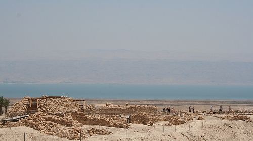
Ashkelon National Park (Tel Ashkelon)
This is the city's premier
landmark and Israel's first declared national park. Located southwest of
the modern city along the Mediterranean shore, it covers the ruins of
ancient Ascalon plus remnants of the former Palestinian village of
Al-Jura. The park combines archaeology, nature (sand dunes, kurkar
cliffs, and Mediterranean vegetation), recreation, and a regulated
beach—making it a unique site for history buffs and beachgoers alike. It
spans about 150 acres, framed by ancient fortifications, and features
layers from multiple civilizations: Canaanite (Middle Bronze Age),
Philistine, Hellenistic, Roman, Byzantine, Muslim, and Crusader.
Key highlights include:
Canaanite Gate (c. 1850 BCE): One of the
world's oldest known arched (vaulted) gateways. Built of mudbrick and
kurkar (calcareous sandstone), it features a 15-meter-long corridor
about 4 meters high and over 2 meters wide, large enough for ox- or
donkey-drawn carts. It was part of massive defenses and remained in use
for roughly 250 years before being buried under later ramparts for
preservation. Nearby, excavations uncovered a small Canaanite temple
with a famous 10.5 cm bronze calf figurine (linked to rituals for gods
like El or Baal; a replica is displayed in local museums). A protective
roof now covers the gate for visitors, who can walk through it via a
wooden path.
Canaanite Ramparts and Fortifications: An enormous
semicircular earthen embankment (glacis) over 2.2 km long, up to 15 m
high, and more than 30 m wide at the base. Built around 2000–1550 BCE,
it supported mudbrick walls and kurkar facing. Later civilizations,
including the Fatimids (mid-12th century) and Crusaders, built upon or
reused these defenses. Remnants of medieval walls (with incorporated
Roman columns) and a moat are visible near the gate; sea erosion has
exposed sections along the coast.
Roman Basilica: A magnificent
2nd–3rd century CE (possibly Herodian-era) colonnaded public building,
about 110 m long. It featured imported marble columns and capitals from
Asia Minor, some with eagle motifs symbolizing Rome. Partially restored
with lawns, playgrounds, and a display of Roman-era sculptures
(including statues of figures like Nike and Isis). This served as a
center of civic life in the Roman period.
Byzantine Wells and Antilia
Pumps: Around 67 wells, mostly from the Byzantine period, scattered
across the park. Some feature Ottoman-era camel-powered "antilia" (chain
pumps) for irrigation, adding a later historical layer.
Other Ruins
and Features: Foundations of a medieval church (St. Mary Viridis) built
into the city walls; remains of a pagan temple later converted to a
church and mosque; and a modern 10,000-seat open-air amphitheater on the
rampart slope for cultural events. The park includes a beach for
swimming (April–October, with lifeguards) and scenic kurkar cliffs
overlooking the sea.
The site offers stunning Mediterranean
panoramas, picnic areas, and trails. Excavations (notably by Harvard's
Lawrence Stager since 1985) have yielded treasures like a silver calf,
Philistine artifacts, and even the largest known ancient dog cemetery.
Other Notable Landmarks
Tomb of Sheikh Awad (Mamluk period, 13th
century): A domed Muslim shrine on a hill north of the park, overlooking
the beaches and promenade. Part of a network of coastal holy sites built
by the Mamluks; it was a prayer site until 1948.
Ashkelon Marina and
Bar-Kochba Promenade/Boardwalk: A lively modern waterfront area north of
the park with a marina for boating, restaurants, and shops. The scenic
boardwalk along the kurkar cliffs features giant environmental
sculptures (e.g., 9m-high whale tails incorporating playgrounds) and
offers panoramic sea views. Nearby is the city beach (Bar Kochba Beach).
Byzantine Church Remains (Barnea Quarter): 4th-century church ruins with
marble slab flooring and glass mosaic walls, accessible in a residential
area.
Maqam al-Nabi Hussein (at Barzilai Medical Center): A Shiite
pilgrimage site believed by some to mark the burial of the head of
Husayn ibn Ali (grandson of the Prophet Muhammad). A marble prayer area
welcomes pilgrims.
Museums and Additional Sites:
Ashkelon
Khan/Majdal Museum (in the old Ottoman mosque of el-Mejdal): Displays
local archaeological finds, including pottery, jewelry, weapons, and a
replica of the Canaanite silver calf.
From Holocaust to Revival
Museum: Focuses on modern Israeli history and revival in the region.
Roman Painted Tombs (near the marina, recently opened to the public):
Rare 2nd–4th century CE vaulted tombs with intricate frescoes depicting
Greek mythology (Demeter, Medusa, nymphs), vines, animals, and
figures—highlighting wealthy Roman-era burials.
Nitsanim Dunes Nature
Reserve (nearby): Expansive sandy dunes for nature walks.
Swimming at one of the various beaches in the city area: Bar Kochba Beach is located in the middle of the marina. Delilah Beach is to the south. Here you will also find the Ashkeluna Aqua Park with water slides, etc.
Best Time to Visit
Spring (March–May) and Fall
(September–November): Ideal with mild temperatures (18–27°C/64–81°F),
lower crowds, and pleasant weather for exploring ruins and beaches.
Wildflowers bloom in spring.
Summer (June–August): Hot and dry (up to
30–32°C+), perfect for beach days and swimming, but expect crowds and
heat. Park hours extend later.
Winter (December–February): Milder but
rainier; shorter days and cooler for outdoor activities.
Check Jewish
holidays (e.g., Passover, Rosh Hashanah, Yom Kippur), as many sites and
businesses close or get very busy.
Where to Stay
Tamara
Ashkelon Hotel: Modern with pool, good reviews for breakfast.
Beachfront or marina-area hotels/apartments for convenience.
Budget:
Guesthouses or B&Bs; mid-range to upscale options available.
Many
places offer sea views; book ahead in peak seasons. Check for kosher
options if relevant.
Food and Dining
Ashkelon has a mix of
Israeli, Mediterranean, seafood, Italian, Asian, and kosher spots. Focus
on fresh, local produce and seafood.
Marina area: Giorgio Caffe
(Italian, kosher dairy), Brasserie Marina, River (Asian), Gatos
(Italian).
Highly rated: Anona (vegetarian/Israeli cafe), Linda
(Mediterranean), Archie (near park).
Try hummus, fresh fish, grilled
meats, salads, or ceviche. Many kosher restaurants (dairy/meat
separation common).
Picnic in the National Park with supermarket
supplies.
Practical Visiting Tips
Duration: 1–2 full days for
main sights; longer for relaxation.
What to Bring: Sunscreen, hat,
comfortable shoes for ruins/trails, swimsuit, reusable water bottle (tap
water is safe). Modest clothing for any religious/historical sites if
needed.
Costs: Israel is not cheap—budget for entry fees (parks),
meals (~moderate), and transport. National Park is affordable.
Accessibility: Many paths in the park are stroller/wheelchair-friendly;
check specifics.
Language: Hebrew primary; English widely understood
in tourist areas.
Customs: Respect local norms (e.g., Shabbat
closures Friday evening–Saturday). Beaches can be lively on weekends.
Safety and Health
Ashkelon is generally safe for visitors, with
residents and tourists reporting high feelings of security, including at
night. It's a coastal city with standard precautions (watch belongings,
swim safely).
However, due to its proximity to Gaza (~9–10 km),
monitor current events, alerts, and official travel advisories (e.g.,
from your government). Security can change; follow local instructions.
Standard Israel tips apply: travel insurance, stay informed, avoid
unattended bags.
No special health risks; drink plenty of water in
heat. Pharmacies and medical care are good.
By train
Ashkelon Train Station is connected to Tel Aviv by two
train lines (from there you can continue to Binjamina, where you can
connect to trains to Haifa). One or two trains run per hour; a single
trip to Tel Aviv costs around 25.00 ₪. The rail connection continues to
Be'er Sheva in the southeast.
Unfortunately, the train station is
4.5 km from the city center around Migdal and almost eight kilometers
from the archaeological park, which means it is no longer within easy
walking distance; visitors arriving by train have to rely on a taxi or
the city bus connections.
By bus
Various buses from the Egged
company connect the Ashkelon Central Bus Station with the most important
cities in the country.
By road
Highway 4, which runs further
north as a motorway, connects Ashkelon along the coast with the greater
Tel Aviv area, road 3 leads northeast to the main road 40 (via Rehovot
to the greater Tel Aviv area and to Ben Gurion Airport) and to the
modern toll highway 6.
Road 35 leads almost exactly east to
Kiryat Gat and road 34 leads southeast to Be'er Sheva, road 4, which
leads south, ends at the border crossing to Gaza, which is currently
closed to travelers.
By boat
The Ashkelon marina can only be
reached by private boats, there is a commercial port in the very south,
and there are no regular passenger or car ferry connections.
The distances in the city and especially to the train station, which is located a little outside of town, are not short; there is a city bus network.
The old town center of Migdal with its numerous shops, boutiques,
snack bars, bars and banks is the place where the residents of Ashkelon
like to do their shopping; part of it is a pedestrian zone. Car traffic
in the streets of the city center is dense, people stop and park in
impossible places; it is much easier to find parking spaces within
walking distance.
The bakery on Eli Cohen Street is worth a visit; it
is open around the clock and offers savory and sweet baked goods fresh
from the oven.
There are various shopping malls on the outskirts of
the city.
In the city with a predominantly Jewish population, Shabbat
is observed and only a few grocery stores are still open on Friday
evenings.
Cheap
Nobi Restaurant, Tsfanya Street (near Afridar). good
shwarma.
in Migdal there are several inexpensive snack bars and
restaurants
Apart from the usual petty crime, there are no threats in modern Ashkelon. However, the city, which is only 13 km from the Gaza Strip, has been the target of rocket attacks by Palestinian extremists since 2008. Due to the proximity, the warning time to reach the air raid shelters is extremely short (30 seconds), and rockets aimed at the city area are countered with the help of an electronic missile defense system.
Prehistory and Early Settlement (Neolithic to Early Bronze Age, c.
5880–2500 BCE)
The earliest traces of human activity at the site date
to the Neolithic period around 5880 BCE, with scattered settlements and
tools. Salvage excavations in the modern neighborhoods of Afridar and
Marina uncovered dwelling pits, silos, hearths, animal bones, and
microlithic tools from the Epipalaeolithic and Chalcolithic eras.
By
the Early Bronze Age I (c. 3700–2900 BCE), a thriving settlement existed
at Afridar, benefiting from groundwater, fertile soils, and trade with
prehistoric Egypt. It was abandoned around 2900 BCE, possibly due to
climate shifts. In Early Bronze Age II–III (2900–2500 BCE), Tel Ashkelon
served as an important seaport for Egypt-Byblos trade, with mudbrick
structures and olive-oil storage jars. Settlement later shifted to the
unwalled Barne’a area during the Intermediate Bronze Age.
Canaanite Period (Middle and Late Bronze Age, c. 2000–1170 BCE)
Ashkelon emerged as a major Canaanite city and the oldest and largest
known seaport in Canaan by around 2000 BCE. It first appears in
historical records in the Egyptian Execration Texts (20th–19th centuries
BCE) as Asqanu, listing local rulers. Fortifications built c. 1800 BCE
included massive earthen ramparts, a moat, guard towers, and the world’s
oldest known monumental arched gate (c. 1770–1740 BCE), which still
stands nearly two stories high today in the national park.
Under
Egyptian influence in the Late Bronze Age (c. 1560–1170 BCE), it fell
under pharaohs like Thutmose III after the Battle of Megiddo (1457 BCE).
Amarna Letters (mid-14th century BCE) from local rulers Shubandu and
Yidya show loyalty to Egypt. The Merneptah Stele (c. 1208 BCE) records
Egyptian plundering of “Asqaluni.” It remained integrated into the
Egyptian empire until the invasions of the Sea Peoples around the time
of Ramesses III.
Key archaeological finds include the impressive
ramparts and gate, plus a Canaanite silver calf figurine from a shrine
near the gate (a replica is displayed in the Ashkelon Khan Museum).
Philistine Period (Iron Age I–II, c. 1170–604 BCE)
Around 1170
BCE, following the Bronze Age collapse, the Philistines (one of the Sea
Peoples, identified as Peleset) settled the site. Ashkelon became one of
the five cities of the Philistine pentapolis (along with Gaza, Ashdod,
Ekron, and Gath), a major cultural and economic center. Philistine
material culture appears with distinctive Mycenaean IIIC pottery, pig
and dog consumption (unlike Canaanite/Israelite diets), and a large
cemetery discovered in 2012–2013 containing over 200 burials with
Cypro-Minoan inscriptions.
Biblically, Ashkelon is frequently
mentioned as a Philistine stronghold (e.g., Joshua 13:3; 1 Samuel 6:17;
Judges; and later prophets). It was a target in conflicts with the
Israelites, including associations with Samson and Delilah. Assyrian
records show it became a vassal under Tiglath-Pileser III (734 BCE),
with revolts suppressed by Sennacherib (701 BCE). It maintained ties to
Egypt and had a temple to Aphrodite/Derketo (pillaged by Scythians c.
653–625 BCE).
The city was violently destroyed by Babylonian king
Nebuchadnezzar II in 604 BCE (one of the last Philistine cities to
fall), with its king Agaʾ exiled. The Babylonian Chronicles and a poem
by Alcaeus describe the sack; the site lay desolate for about 70 years.
Excavations by the Leon Levy Expedition (1985–2016) uncovered Philistine
layers, including a marketplace and the large dog cemetery (nearly 800
sacred Canaan dog burials from the Persian period, possibly linked to a
healing cult).
Persian, Hellenistic, and Roman Periods (c. 520
BCE–4th century CE)
Rebuilt in the Persian period (c. 520–332 BCE)
under Phoenician (Tyrian) influence, Ashkelon minted coins and imported
goods from Greece and Cyprus. It surrendered to Alexander the Great in
332 BCE and became known as Ascalon in its Hellenized form. It changed
hands between Ptolemies and Seleucids, gaining polis status and minting
coins. It remained largely independent and neutral in later conflicts.
Under Roman rule (from 63 BCE, after Pompey), it was granted free-city
status (civitas libera et immunis). Herod the Great (despite disputed
birth claims there) beautified it with baths, fountains, colonnades, and
a massive Roman basilica (one of the largest in the country, with
imported marble columns and eagle motifs, dated to his reign 37–4 BCE;
recently restored and opened to the public). A Jewish community existed
but faced tensions; during the First Jewish-Roman War, locals massacred
Jews.
Byzantine and Early Islamic Periods (4th–1099 CE)
Christianity spread from the 4th century CE, with bishops attending
early councils and martyrs under Diocletian and Julian. It appears on
the 6th-century Madaba Map. The city flourished with bathhouses (one
4th–6th century site yielded evidence of possible prostitution and
nearly 100 discarded male infant remains) and a Byzantine church with
mosaics.
It surrendered to Muslim forces under Mu’awiya I around 640
CE after a siege, becoming a fortified garrison. It changed hands
briefly with Byzantine reconquests but was rebuilt under Umayyads,
Tulunids, and Fatimids. Al-Maqdisi and Nasir Khusraw praised its
markets, mosque, and silk production. A shrine to Husayn’s head (11th
century) became a pilgrimage site.
Crusader Period and
Destruction (1099–1270 CE)
A major Fatimid stronghold, Ashkelon
(called Ascalon by Crusaders) resisted the First Crusade. The Battle of
Ascalon (1099) was the Crusade’s final engagement, but the city held out
until a prolonged siege in 1153, when Baldwin III captured it; the
mosque became a cathedral. It served as a key port and county seat.
Saladin recaptured and partially destroyed it in 1187; Richard the
Lionheart briefly refortified it in 1192. Final Crusader control ended
in 1247 under Baybars.
In 1270, Mamluk sultan Baybars ordered the
complete destruction of the fortifications and harbor to deny it to
future Crusaders. Inhabitants relocated inland to the village of Majdal
‘Asqalān (al-Majdal), about 3 km away.
Ottoman Period and
al-Majdal (15th–19th centuries)
Al-Majdal grew into a prosperous Arab
village under Ottoman rule, known for weaving (majdalawi textiles),
agriculture, and its location on the Cairo-Damascus road. By the late
19th century, it had hundreds of households, mosques, and shrines
(including the Maqam al-Imam al-Husayn, later destroyed in 1950).
Population was predominantly Muslim with a small Christian minority.
Modern History: 1948 War, Depopulation, and the Israeli City (20th
century–present)
In the 1947 UN Partition Plan, the area was
allocated to the Arab state. During the 1948 Arab–Israeli War, Egyptian
forces occupied al-Majdal. Israeli forces captured it on November 4–5,
1948 (Operation Yoav). Most of the ~10,000–11,000 Arab residents fled or
were expelled; the remaining population was gradually deported to Gaza
and elsewhere by 1950 amid controversy and legal proceedings. The
village was largely depopulated, with some structures (like the Husayn
shrine) destroyed.
In 1949, Israel founded the new town of Migdal
(later Migdal Ashkelon) on and near the site, initially settling Jewish
immigrants from Yemen, North Africa, Europe, and demobilized soldiers in
ma’abarot (transit camps). It was renamed Ashkelon in 1953 after
incorporating the coastal Afridar neighborhood. The ancient site became
Ashkelon National Park, preserving ruins from all periods (Canaanite
gate, Roman basilica, Fatimid walls, etc.). Major excavations,
especially the Leon Levy Expedition, have revealed artifacts like the
silver calf, Philistine cemetery, and dog burials.
Ashkelon (also spelled Ashqelon or Ascalon in historical contexts) is
a coastal city in Israel's Southern District, situated directly on the
Mediterranean Sea in the southwestern part of the country. It lies on
the southern section of Israel's coastal plain (sometimes referred to as
the Judean or Philistine Coastal Plain), approximately 50 km (31 mi)
south of Tel Aviv and only 13 km (8 mi) north of the Gaza Strip border.
The modern city was established in 1949 on the site of the former
Palestinian town of al-Majdal (Majdal Ashkelon), about 4 km inland from
the ancient seaport ruins of Tel Ashkelon, which sit on the southwestern
edge of the contemporary urban area.
Geographically, Ashkelon
occupies roughly 47.8 km² (about 18.5 sq mi) of low-lying coastal
terrain. Its coordinates are approximately 31°40′N 34°34′E (or more
precisely around 31.669°N 34.571°E). The city sits within the broader
Israeli coastal plain, a fertile, sandy strip that runs along the
Mediterranean and narrows northward but widens in the south near
Ashkelon. Topographically, the area is predominantly flat to gently
undulating, with an average elevation of about 31 m (102 ft) above sea
level—ranging from sea level at the beaches to a maximum of around 69 m
(226 ft) in the city vicinity. This low relief made it historically
vulnerable to invasions but advantageous for agriculture and maritime
trade.
The standout geological and topographic features are the
parallel kurkar ridges—fossilized Pleistocene-era eolian
(wind-deposited) sandstones or aeolianites that form distinctive coastal
cliffs and elevated backshores. These ridges, remnants of ancient dune
systems, run sub-parallel to the shoreline: one along the immediate
coast (exposed as 6–18 m / 20–59 ft high cliffs with narrow sandy
beaches at their base) and a second roughly 550 m (1,800 ft) inland. The
coastal kurkar provides natural elevation and was shaped in antiquity by
Canaanites into massive semi-circular earth ramparts enclosing the
ancient tell (mound) of Ashkelon, which covers over 150 acres (60 ha).
Holocene sand dunes and beachrock (lithified coastal deposits) further
characterize the shoreline, with some ongoing erosion on the cliffs.
The coastline itself features long stretches of sandy beaches
interspersed with these kurkar cliffs and a narrow beach zone. Prominent
beaches include Delila Beach and Bar Kochba Beach, backed by high-rise
development in places. Between them lies the Ashkelon Marina, which
serves as a harbor with shipyard facilities. Ashkelon National Park,
located southwest of the modern city along the ancient tell, preserves a
mix of coastal dunes, kurkar outcrops, cliffs, and beaches—creating a
scenic protected landscape.
Ashkelon's climate is classic
hot-summer Mediterranean (Köppen classification Csa), featuring long,
warm-to-hot, dry summers and mild, wetter winters. Annual average
temperature hovers around 20.2°C (68.3°F). Summers (June–September) are
arid and often muggy, with August averaging about 27.1°C (80.8°F) and
daytime highs frequently exceeding 30°C (86°F). Winters (December–March)
are cooler, with January averaging around 12.8°C (55°F) and lows near
10–12°C (50–54°F). Precipitation totals roughly 400–510 mm (16–20
inches) per year, concentrated in the wet season from late October to
early April (about 5.3 months of notable rain). January is the wettest
month (around 127 mm / 5 inches on average), while summers are nearly
rainless (August often sees just 2 mm). The area experiences mostly
clear skies, moderate humidity in summer, and prevailing westerly sea
breezes that moderate temperatures.
Hydrologically, Ashkelon
benefits from the Coastal Aquifer, a major freshwater source with a
historically high water table that supported ancient wells and
irrigation systems. Short seasonal streams cross the plain, but there
are no major permanent rivers. Modern infrastructure includes one of the
world's largest seawater reverse osmosis desalination plants, which
helps manage water resources amid the region's semi-arid transition
southward. Soils are typically sandy to loamy, supporting agriculture in
the surrounding hinterland (historically citrus, grains, and now varied
crops).
Environmentally, the coastal plain around Ashkelon blends
Mediterranean and semi-arid influences. In Ashkelon National Park and
dune areas, vegetation includes desert-adapted species like white broom
(Retama raetam), Artemisia monosperma, and spiny broom, mixed with
Mediterranean elements. Coastal specialists such as sea daffodils (or
sea lilies) and sea cudweed thrive due to salt spray and sandy
substrates. The area forms part of a broader ecological corridor along
the Mediterranean, though urban and agricultural development has
modified much of the natural landscape.