Location: Route 66, 35 km (22 mi) South- East of Haifa Map
Tel. (04) 659 0316
Open: 8am- 4pm daily
Winter: 8am- 3pm daily
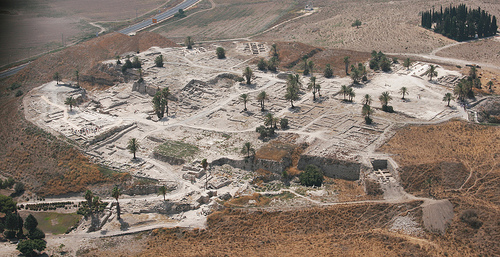
Megiddo, located in the Jezreel Valley of northern Israel, is one of the most significant archaeological and historical sites in the Middle East, often referred to as Tel Megiddo or Tel el-Mutesellim (Arabic). Situated approximately 30 kilometers southeast of Haifa and 10 kilometers southwest of Afula, it is a UNESCO World Heritage Site renowned for its strategic location, extensive archaeological remains, and biblical associations, including its identification with Armageddon (Revelation 16:16). The site, a multi-layered tell (mound) rising 60 meters above the valley, spans over 5,000 years of human history, from the Neolithic period to the Persian era.
Megiddo occupies a commanding position in the western Jezreel
Valley, at the edge of the Carmel Ridge, overlooking the fertile
plain. Its coordinates are approximately 32.585°N, 35.182°E, and it
sits 150–200 meters above sea level. The site’s strategic location
along the Via Maris, the ancient trade route connecting Egypt to
Mesopotamia, made it a vital crossroads for commerce and military
campaigns.
Topography:
The tell is an oval-shaped mound,
roughly 15 hectares at its base and 1 hectare at its summit, formed
by successive layers of settlement debris. The surrounding Jezreel
Valley provides flat, fertile land, ideal for agriculture, while the
nearby Kishon River and springs (e.g., Ein el-Kubbi) ensured a
reliable water supply.
The site’s elevation offered a defensive
advantage, with clear views of the valley, making it a natural
fortress. The nearby Nahal Iron (Wadi Ara) pass was a critical
chokepoint for controlling regional traffic.
Climate and
Environment:
Megiddo experiences a Mediterranean climate, with
hot, dry summers (25–35°C) and mild, rainy winters (10–15°C, 500 mm
annual rainfall). The valley’s fertility supported crops like wheat,
olives, and grapes, sustaining large populations.
The surrounding
landscape includes oak and pistachio woodlands, seasonal wetlands,
and diverse wildlife (e.g., birds, foxes, gazelles). The site’s
springs and proximity to water sources fostered settlement and
agriculture.
Megiddo’s archaeological record spans from the Neolithic period (ca.
7000 BCE) to the Persian period (ca. 4th century BCE), with 26 major
settlement layers identified. Excavations, beginning in 1903 and
continuing intermittently to the present, have revealed palaces,
temples, fortifications, and a sophisticated water system, making it
a key site for understanding the Bronze and Iron Ages in the Levant.
Key Archaeological Features:
Canaanite City (Early and Middle
Bronze Ages, ca. 3000–1500 BCE):
Megiddo was a major Canaanite
city-state, with massive fortifications, including a 4-meter-thick
city wall and a monumental gate. The “Great Temple” (Stratum XV, ca.
2500 BCE), a 50x30-meter structure with a large altar, is one of the
largest known from the period, indicating a significant religious
center. Its double-basalt altar and nearby cultic artifacts suggest
ritual practices, possibly involving animal sacrifice.
The
“Sacred Area” near the northern edge of the tell includes a series
of temples and a circular stone altar (the “Round Altar”), used for
centuries. A deep shaft tomb (Tomb 50) from the Middle Bronze Age
contained elite burials with grave goods like pottery and jewelry.
The Canaanite palace (Stratum XII–X), located on the tell’s eastern
side, featured mudbrick walls and a courtyard, reflecting
administrative power. A four-chambered gate from this period is a
highlight of the site.
Late Bronze Age (ca. 1500–1200 BCE):
Megiddo was under Egyptian influence, as evidenced by references in
the Amarna Letters (14th century BCE) and a battle against Thutmose
III in 1457 BCE, recorded on Egyptian stelae. The “Ivory Palace”
(Stratum VIIIA) yielded treasures, including 382 ivory carvings (now
in the Israel Museum), depicting mythological scenes and daily life.
The city’s fortifications were strengthened, and a new palace
complex included a treasury with gold and alabaster artifacts.
Israelite Period (Iron Age, ca. 1200–732 BCE):
Megiddo became
a major administrative center under the United Monarchy (10th
century BCE), possibly during King Solomon’s reign (1 Kings 9:15).
The six-chambered gate (Stratum VA–IVB) and adjacent casemate walls
are attributed to this period, though some scholars debate whether
they date to the Omride dynasty (9th century BCE).
The “Solomonic
Stables” (Stratum IVA), once thought to be horse stables, are now
interpreted as storehouses or barracks, with troughs for storage
rather than feeding. These structures, found in two complexes
(northern and southern), could house 450 horses or serve as
granaries.
The water system, a marvel of Iron Age engineering,
includes a 35-meter-deep shaft and a 70-meter-long tunnel, dug
through bedrock to access the Ein el-Kubbi spring outside the city
walls. This ensured a secure water supply during sieges.
Water System:
The water system, likely constructed in the 9th
century BCE under King Ahab, is a highlight for visitors. Workers
carved the tunnel from both ends, meeting with remarkable precision.
A plastered basin at the spring’s end collected water, which was
carried to the city via a hidden entrance. The system was sealed
after the Assyrian conquest (732 BCE).
Assyrian and Later
Periods:
After Tiglath-Pileser III’s conquest in 732 BCE, Megiddo
became the capital of the Assyrian province of Magiddu. Stratum III
features a planned city with a grid layout, administrative
buildings, and a governor’s residence. A large granary, 11 meters in
diameter, stored surplus grain.
Persian-period remains (5th–4th
centuries BCE) include a small fortress and pottery, marking the
city’s decline as a regional center.
Excavations and
Research:
Excavations began with Gottlieb Schumacher (1903–1905)
for the German Oriental Society, followed by the University of
Chicago’s team (1925–1939), led by Clarence Fisher, P.L.O. Guy, and
Gordon Loud. The Chicago team uncovered the stables, water system,
and major strata, producing detailed publications.
Since 1992,
Tel Aviv University, led by Israel Finkelstein and David Ussishkin,
has conducted ongoing excavations, refining the chronology using
radiocarbon dating. The Megiddo Expedition’s open-access data and 3D
models enhance global research.
Key finds include cuneiform
tablets, seals, and the “Megiddo Ivories,” which reflect cultural
exchanges with Egypt, Mesopotamia, and the Aegean. The site’s
stratigraphy is a benchmark for Levantine archaeology, though
debates persist over the dating of “Solomonic” structures (e.g.,
Finkelstein’s Low Chronology vs. traditional high chronology).
Destruction Layers:
Megiddo experienced multiple
destructions, evidenced by ash layers and collapsed structures.
Notable events include an Egyptian attack (ca. 1457 BCE), a possible
Sea Peoples invasion (ca. 1200 BCE), and the Assyrian conquest (732
BCE). These layers provide insights into warfare, trade disruptions,
and cultural shifts.
Megiddo’s history reflects its role as a geopolitical and cultural
hub.
Bronze Age (3000–1200 BCE):
As a Canaanite
city-state, Megiddo controlled trade routes and agricultural
surplus, engaging with Egypt, Mesopotamia, and Anatolia. Its wealth
is evident in elite burials and imported goods like Cypriot pottery.
Thutmose III’s victory in 1457 BCE marked Egypt’s dominance, with
Megiddo serving as a vassal city. The Amarna Letters mention
Megiddo’s king, Biridiya, navigating tensions with neighboring
Shechem.
The Late Bronze Age collapse (ca. 1200 BCE) weakened
Megiddo, possibly due to Sea Peoples or internal strife, leading to
a smaller Iron I settlement.
Iron Age (1200–732 BCE):
Megiddo’s revival under the Israelites made it a royal city,
possibly fortified by Solomon or Jeroboam I. The Bible describes it
as a chariot city (1 Kings 4:12, 9:15), aligning with the
stables/storehouses.
The Omride dynasty (9th century BCE) likely
expanded the city, with Ahab’s water system reflecting royal
investment. The “Jezreel Incident” (2 Kings 8:29) and battles
against Aram-Damascus highlight its military role.
The Assyrian
conquest in 732 BCE ended Israelite control, with Megiddo repurposed
as an administrative center. The death of King Josiah at Megiddo in
609 BCE (2 Kings 23:29) against Pharaoh Necho II underscores its
continued strategic importance.
Later Periods:
Under
Persian rule, Megiddo declined, with minimal Hellenistic and Roman
activity. Nearby Legio, a Roman military camp (2nd century CE), and
the Jewish village of Kefar ‘Othnay eclipsed the tell.
The site
was largely abandoned by the Byzantine period, though Christian
interest in its Armageddon connection grew.
Megiddo’s cultural and religious significance spans ancient
practices and modern interpretations.
Ancient Religion:
The Canaanite temples and altars suggest worship of deities like
Baal or Asherah, with possible human sacrifice in early strata
(based on infant burials). The Round Altar and Great Temple were
central to communal rituals.
Israelite layers lack clear cultic
structures, reflecting monotheistic shifts, though a small shrine
with incense altars was found in Stratum V.
The site’s springs
may have held ritual significance, as water sources often did in
ancient Near Eastern cultures.
Biblical and Apocalyptic
Associations:
Megiddo is linked to biblical battles, including
Deborah’s victory (Judges 5:19) and Josiah’s death (2 Chronicles
35:22). Its Hebrew name, Har Megiddo (“Mount of Megiddo”), inspired
the term “Armageddon” in Revelation 16:16, symbolizing an
apocalyptic final battle.
Christian pilgrims visit Megiddo for
its eschatological significance, while Jewish and secular visitors
focus on its Israelite heritage.
Modern Cultural Role:
Megiddo is a symbol of Israel’s historical depth, featured in
educational curricula and tourism campaigns. Its UNESCO status
(inscribed 2005, alongside Hazor and Beer Sheba) underscores its
global value.
The site inspires art, literature, and media, with
“Armageddon” evoking themes of conflict and destiny.
Megiddo National Park, managed by the Israel Nature and Parks
Authority, is a premier destination for tourists, archaeologists,
and pilgrims.
Key Attractions:
City Gate and Walls: The
Canaanite and Israelite gates, with their massive stonework, are
accessible via a ramp. The six-chambered gate offers views of the
valley.
Water System: Visitors can walk through the 70-meter
tunnel, descending 183 steps to the spring and exiting via a path
outside the tell. The tunnel’s engineering is a highlight, though
the climb back is strenuous.
Stables/Storehouses: The northern
and southern complexes, with their stone troughs, are
well-preserved, offering insights into Iron Age logistics.
Sacred
Area: The Round Altar and temple remains are visible, with signage
explaining their ritual use.
Palace and Granary: The Canaanite
palace foundations and Assyrian granary are marked, with views of
the excavation trenches.
Visitor Center: A modern facility offers
a 3D model of the tell, a film on Megiddo’s history, and a small
museum with replicas of key finds (originals are in the Israel
Museum and Rockefeller Museum).
Visitor Logistics:
Access:
From Tel Aviv or Jerusalem, a 1–1.5-hour drive via Highway 6 or
Route 65 reaches the site. The Jezreel Valley Railway stops at Afula
(15 km away), with buses or taxis to Megiddo. The park is 2 km from
Megiddo Junction.
Hours and Fees: Open daily (8 AM–5 PM
April–September, 8 AM–4 PM October–March; last entry 1 hour before
closing). Entrance costs ~28 NIS (adults), ~14 NIS (children), with
discounts for groups. A Nature and Parks Authority pass covers
multiple sites.
Facilities: The visitor center includes
restrooms, a café, and a gift shop. Picnic areas and shaded benches
are available. The site is partially wheelchair-accessible (upper
tell only).
Guided Tours: Park rangers offer free tours in
Hebrew/English (check schedules). Private guides or audio guides
enhance the experience. Group tours often combine Megiddo with Beit
She’an or Nazareth.
Tips: Wear sturdy shoes for the tunnel and
bring water, hats, and sunscreen, as the site is exposed. Spring
(March–April) and autumn (September–October) are ideal for visiting
due to mild weather.
Nearby Attractions:
Beit She’an
National Park (30 km east): Roman ruins, including a theater and
mosaics.
Harod Spring (20 km east): A natural pool and kibbutz
history.
Mount Gilboa (25 km southeast): Hiking trails and iris
blooms.
Nazareth (25 km north): Christian sites like the Basilica
of the Annunciation.
Megiddo remains a well-preserved and actively studied site, but it
faces challenges:
Preservation: Exposure to weather and
tourism foot traffic threatens delicate structures. The Israel
Antiquities Authority uses protective coverings and restricts access
to fragile areas.
Funding and Excavation: Ongoing digs rely on
university and international support. Balancing research with
tourism demands careful planning.
Geopolitical Context: Located
in Israel’s north, Megiddo is stable but near the West Bank (Jenin,
20 km away), requiring security awareness. The site is safe for
visitors, with no recent incidents.
Interpretation Disputes:
Debates over the “Solomonic” gate’s dating and the stables’ function
highlight ongoing scholarly tensions, impacting how the site is
presented to the public.