Location: At Bashy district, Naryn Province Map
Tash Rabat (meaning "stone fortress" or "stone lodging") is a
well-preserved 15th-century (possibly earlier, 10th-century origins)
Silk Road caravanserai in Kyrgyzstan's Naryn Province, At-Bashy
District. It sits in a remote, dramatic valley in the Tian Shan
mountains at about 3,200–3,500 meters (10,500–11,500 ft) altitude,
roughly 90 km from the Torugart Pass on the Chinese border.
This
UNESCO-associated site feels like stepping back in time: a sturdy
stone structure with thick walls, a central dome, labyrinthine rooms
(once for sleeping, storage, prayer, and even a dungeon), and an
isolated setting that evokes the perils and wonders of ancient
caravan travel.
Best Time to Visit
June to September is ideal. Roads are open,
weather is milder (daytime 10–20°C/50–68°F, but nights can drop near
freezing), and hiking/horse riding is feasible. July–August is peak
(warmer, busier). Avoid November–April due to snow-blocked roads and
harsh conditions. Shoulder months (May/October) work but prepare for
variability.
Weather note: Conditions change rapidly at altitude—sun,
rain, hail, snow, or wind can hit in hours. Always layer up.
How
to Get There
No public transport reaches Tash Rabat directly. Options
from Naryn (the main hub, ~2–3 hours away, often via Kochkor):
Rented
4x4 with driver — Most common and recommended. Roads include paved
sections then rough dirt tracks. Bishkek to Naryn is 5–6 hours; total
from Bishkek ~8–10+ hours.
Tours — Many Bishkek/Naryn operators offer
packages including yurt stays and activities.
Hitchhiking — Feasible
on the main road (busy with trucks/workers), then the 15–17 km side
track, but unreliable and not for everyone.
Self-drive — Possible for
experienced drivers with a sturdy vehicle, but risky due to isolation
and poor phone signal.
Entry fee: Around 150 SOM (~$1.70 USD) —
pay on-site; someone from a nearby yurt camp usually opens it.
What to Expect On-Site
Explore the interior: Dark, atmospheric stone
corridors and rooms (bring a headlamp/flashlight). It's not heavily
restored—feels authentic.
Hiking & activities: Short walks around the
valley; longer treks to passes (~4,000m), nearby lakes like Chatyr-Kul
(requires border permit—arrange in advance via CBT Naryn, ~2,000 SOM).
Horse riding with locals (~$10/day + guide).
Landscape: Epic, serene,
with yaks, horses, and nomadic herders.
Altitude: Acclimatize
properly. Symptoms like headache/nausea are common—hydrate, ascend
slowly, consider Diamox if prone. Carry snacks, water, and meds.
Where to Stay
Highly recommended to overnight—sunrise/sunset and
stargazing are magical, and it immerses you in the experience. Several
yurt camps nearby (e.g., Sabyrbek Yurt Camp, first one you reach).
Expect felt yurts with beds, colorful textiles, and communal dining.
Meals (breakfast/dinner) usually included: hearty Kyrgyz food (plov,
lagman, kymyz fermented mare's milk, fresh bread).
Cost: 1,500–2,000
SOM (~$17–22 USD) per person/night.
Some have basic cottages or
Western-style toilets/showers; others more rustic. Camping possible in
the valley (cold at night).
Practical Visiting Tips
Packing
essentials: Warm layers (fleece, down jacket, hat/gloves even in
summer), rain shell, sturdy hiking boots, headlamp, power bank (limited
electricity), offline maps (Maps.me or similar), cash (SOM—limited
ATMs), snacks, altitude meds, sunscreen, insect repellent, reusable
water bottle.
Health & safety: Kyrgyzstan is generally safe, but
remote area means limited services. Tell someone your plans. Respect
locals/nomads. No major crime issues reported here.
Border permit for
extensions (e.g., Chatyr-Kul): Get in Naryn ahead of time.
Connectivity: Poor/no signal—download everything offline.
Cultural
tips: Remove shoes in yurts, accept hospitality graciously, learn basic
Kyrgyz/Russian phrases. Photography is fine but ask for people.
Sustainability: Pack out trash; support local yurt camps.
Duration: 1–2 nights ideal for relaxation and hikes; day trip possible
but rushed.
Origins and Debated History
The exact origins of Tash Rabat
remain uncertain and are the subject of scholarly debate.
Many
sources date its construction as a caravanserai to the 15th century,
during a period of active Silk Road trade under the influence of the
Moghulistan kingdom or local Kyrgyz rulers. It likely served as a
fortified inn providing shelter, rest, supplies, and protection from
bandits and harsh mountain weather for merchants, travelers, and
caravans.
Earlier theories suggest it (or a predecessor
structure) originated in the 9th–11th centuries (or possibly 10th
century) as a monastery. Soviet-era research by the Kyrgyz Academy
of Sciences in the late 1970s–early 1980s proposed it began as a
Nestorian Christian monastery, though no Christian artifacts were
found. Other interpretations point to a Buddhist monastery based on
inscriptions, artifacts, and the religious context of the region
before the spread of Islam. It may have been converted into a
caravanserai as trade increased and Islam became dominant in Central
Asia.
Local legends add color: one attributes it to a
powerful khan or his sons who built it to promote trade and
hospitality. Another tells of a father and son constructing it; the
son abandons the final dome stone to join a caravan and a woman,
leaving it unfinished.
Architecture and Function
The
rectangular stone structure (built on an artificial platform with
walls of rubble stone on clay mortar) features:
Around 31–34
rooms, including a large central domed hall.
Smaller chambers
used as sleeping quarters, storerooms, prayer rooms, and possibly a
dungeon.
Domes with light openings (oculi), squinches for
structural transition, and thick fortress-like walls.
It
stands out as one of the best-preserved stone monuments along the
Silk Road, unusual in a region dominated by nomadic yurt culture.
Caravans heading west could branch toward the Fergana Valley or
Issyk-Kul Lake.
Later History and Significance
Tash Rabat
declined with the waning of the Silk Road but retained its role as a
waypoint. It survived remarkably intact due to its remote,
high-altitude location and solid construction. Today, it is a major
historical and tourist site in Kyrgyzstan, symbolizing the country's
Silk Road heritage. A local caretaker oversees it, and visitors can
explore the dark interior and surrounding dramatic mountain
landscape.
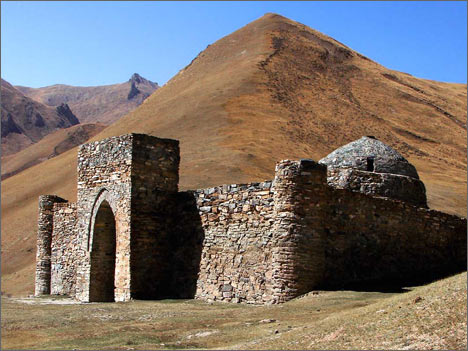
Exterior Architecture
The structure is a nearly square building,
roughly 33.7 x 35.7 meters, resembling a medieval castle or fortress. It
sits on an artificial platform partially built into a hillside, with the
western side embedded in the slope.
Main facade (east-facing):
Features a monumental arched portal entrance flanked by corner towers
(or turrets/minaret-like columns). A wide stone-paved ledge or sufa
(bench platform) runs along the front.
Walls: Thick, solid rubble
stone construction on clay mortar (with gypsum for sealing joints),
using local slate. The eastern wall is tall and imposing; the other
three sides have no doors or windows, giving a fortress-like
defensiveness. Side walls slope with the terrain.
Roof: Mostly
flat/horizontal with a prominent spherical dome on the western/central
part. Corner towers and the overall mass create a compact, harmonious
silhouette against the dramatic mountain backdrop.
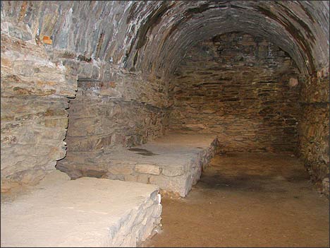
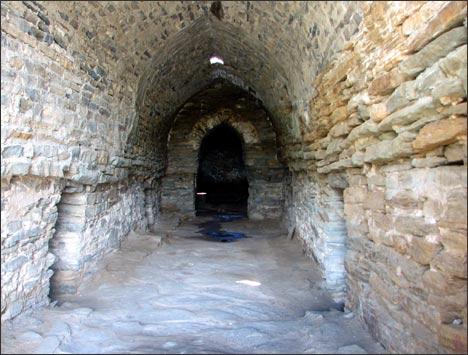
Interior
Layout and Features
Inside, Tash Rabat feels like a labyrinth, with a
central corridor running east-west from the entrance to a large square
central hall under the main dome. Around 31 rooms (including chambers
off the hall) branch off the corridor and hall—mostly small square or
rectangular cells, plus some longer spaces.
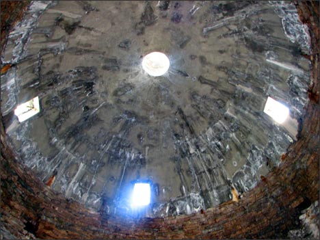
Domes and Vaulting:
Many rooms feature individual domes or vaults with oculus-like openings
at the top for natural light and ventilation. Transitions from square
bases to circular domes use squinches (a classic Central Asian/Islamic
architectural technique). There are around 20 smaller domes plus the
larger central one.
Floors and Details: The central corridor and hall
have flat stone paving; other rooms have earthen floors. Some rooms
include wall ledges, a deep well-like hole (one ~2.7m deep), and spaces
interpreted as a mosque, dungeon, or storage.
Atmosphere: Dimly lit
by roof openings, the thick stone walls (1–1.85m) create a cool, damp,
echoing interior that feels mysterious and protective.
The entire
complex demonstrates sophisticated medieval engineering adapted to a
harsh high-altitude environment, using local materials for durability.
It was restored in the 1980s.
Location and Coordinates
Coordinates: Approximately 40°49′23″N
75°17′20″E.
It lies about 520 km southeast of Bishkek, roughly 125 km
from Naryn town, and around 90 km short of the Torugart Pass on the
border with China.
The site sits in a side valley (Kara-Koyun Gorge
or Tash-Rabat Valley) off the main north-south highway, about 15 km up a
gravel road from the main route.
Elevation and Terrain
Altitude: Around 3,200–3,500 meters (10,500–11,500 ft) above sea level.
It nestles in a narrow, verdant valley carved by the Tash-Rabat River (a
tributary of the Kara-Koyun River), with the structure partially
embedded into a hillside.
The surrounding landscape features rolling
hills and slopes covered in tussock grass, giving a corduroy-like
appearance. Higher up are rugged, rocky mountain slopes of the Tian Shan
(Tien Shan) range, part of the At-Bashi Mountains.
Nearby
Features
To the south: Lake Chatyr-Kul (a high-altitude lake) and the
Torugart Pass (leading to China).
To the north: The ruined fortress
of Koshoy Korgon.
The area is part of the dramatic Tian Shan
("Celestial Mountains") system, with towering peaks, deep gorges, and
glacial influences.
Climate and Accessibility
Climate: Harsh,
high-mountain continental climate. Summers are mild (up to ~+25°C), but
winters are severe (down to -30°C). Snow can block access roads for up
to 8 months a year. Altitude sickness is a real risk due to the
elevation.
The terrain is open and exposed, with herds of horses,
yaks, sheep, and goats grazing on the pastures. It feels isolated and
meditative, evoking the challenges of ancient Silk Road travel.