Location: Beqaa Valley, Beqaa Governorate Map
Anjar is an ancient and medieval archaeological site situated in Beqaa Valley in the Beqaa Governorate of Lebanon. Its name is derived from Arab word of Ain Gerrah or "water source of Gerrah". Gerrah was a local deity that protected the city and its residents. Anjar Archaeological Site was found around 714 AD (according to the Byzantine Greek historian Theophanes the Confessor) as a trading post on the crossroads of trading routes in the Bekaa Valley. They linked Damascus with southern provinces of the Middle Eastern towns. Soon the city grew in size and importance. Archeological digs in the 20th century revealed a rectangular city, surrounded by defensive city walls and forty towers. City gates decorated by porticos led to two main streets of Anjar that crossed the city from North to South and from East to West thus diving the city into four equal sectors.
Most of Anjar Archaeological Site structures date back to the 8th century AD. The city was inhabited for just several decades before it was abandoned during Umayyad Dynasty period and rediscovered only in 1940. During its brief period of existence, Anjar residents constructed numerous public and private structures. The palace of Khalifa was located in the South- Eastern part of Anjar and the main mosque of the city stood in the North- Eastern part of the city. Western part of the city was largely taken by private residencies of common residents of Anjar. Many of the houses also contained large areas reserved for various animals that once lived here. During early Medieval period it had to be one of the smelliest places in the city as hundreds of camels, horses, donkeys and other animals were cramped along human residencies.
Etymology and Pre-Umayyad Context
The name Anjar derives from
Arabic 'ayn al-jaar (or similar variants like Ain Gerrha or Ain guer),
roughly translating to "source/spring of the flowing water," "water from
the rock," or "running/unresolved river." This refers to the abundant
springs and streams in the area fed by the Lebanon and Anti-Lebanon
mountain ranges, including sources of the Litani River. The site was
also known historically as Haouch Mousa. Some accounts loosely link it
to an ancient Hellenistic-era settlement called Gerrha founded by the
Ituraeans (Arab tribes), but there is no evidence of major continuous
habitation or significant structures predating the Umayyads. The Umayyad
city was largely built on virgin soil, though some spolia (reused
materials) from earlier periods appear in its construction.
The
Umayyad Palace-City (Early 8th Century)
Anjar's most famous
historical feature is its Umayyad ruins, founded around 705–715 CE by
Caliph al-Walid I (Walid ibn Abd al-Malik, r. 705–715) as a planned
palace-city and inland commercial hub. Some sources attribute initial
construction to his son al-Abbas (per Byzantine chronicler Theophanes
the Confessor, dating it to 709–710), while Syriac graffiti in the
nearby quarry and other chronicles point to 714 and credit Walid I
directly.
Strategically located at the crossroads of major trade
routes—one linking Beirut to Damascus and another crossing the Bekaa
Valley from Homs to Tiberias (the Sea of Galilee)—Anjar (then sometimes
referred to in the context of its springs) served as a commercial and
administrative center in the expanding Umayyad Caliphate (661–750 CE),
the first hereditary Islamic dynasty. It exemplified early Islamic urban
planning, blending Roman/Byzantine influences with emerging Islamic
architectural elements.
The fortified city covered roughly 114,000
square meters within rectangular walls (about 385 x 350 m, with
variations in measurements across sources) over 2 meters thick and 7
meters high, flanked by around 40 towers and four gates with porticos. A
strict grid layout featured a main north-south cardo maximus and
east-west decumanus maximus intersecting at a monumental tetrapylon
(four-arched structure using reused Roman columns). These axes included
underground sewers. The city was divided into four quadrants:
Southeast: The grand caliphal palace (about 59 x 70 m, with arcades and
a peristyle courtyard) and mosque (45 x 32 m) on higher ground.
Northeast: Smaller palaces (harems) and Roman-style thermal baths for
practical water management.
Northwest and southwest: Residential
quarters, secondary buildings, and an estimated 600 shops.
Construction incorporated proto-Byzantine styles evolving toward Islamic
art, with decorative and structural innovations visible in columns,
arches, and ornamentation. It was never completed and flourished only
briefly as a thriving trading post. In 744 CE, during the turbulent end
of Umayyad rule, Caliph Ibrahim (son of al-Walid I) was defeated nearby
by his cousin Marwan II; the city was damaged, partially destroyed, and
abandoned as the Abbasids overthrew the Umayyads and shifted the
caliphate's focus eastward to Baghdad.
The ruins—excavated starting
in the late 1940s—represent a rare, precisely dated snapshot of Umayyad
civilization and 8th-century town planning. They were inscribed as a
UNESCO World Heritage Site in 1984 under criteria (iii) and (iv) for
their outstanding testimony to Umayyad culture and as an exceptional
example of early Islamic urbanism.
Obscurity and the Land Between
Eras (744–1939)
After abandonment, the site reverted to agricultural
and pastoral use with no major recorded settlements or developments. The
area remained known locally as pasture and grazing lands (Haouch Mousa),
owned in the early 20th century by a retired Ottoman/Turkish military
officer named Rushdi Hoja Tuma (or Rushdi Bey), who held a large domain
of about 1,540 hectares. The ruins lay largely forgotten until
archaeological discoveries in the late 1940s.
Armenian
Resettlement and Founding of Modern Anjar (1939–1940s)
The modern
town owes its existence to one of the most dramatic episodes in
20th-century Armenian history. In 1939, following the cession of the
Sanjak of Alexandretta (Hatay) from French-mandated Syria to Turkey,
thousands of Armenians from Musa Dagh—the mountainous coastal region in
modern Turkey famous for the 1915 resistance against Ottoman deportation
during the Armenian Genocide (immortalized in Franz Werfel's novel The
Forty Days of Musa Dagh)—faced renewed threats and fled.
About 1,060
families (roughly 4,500–6,000 people) from six main villages (Kheder
Beg, Bitias, Haji Habibli, Kabusiye, Yoghunoluk, and Vakef) were
temporarily sheltered at Ras al-Basit in Syria before the French High
Commission negotiated the purchase of Rushdi Bey's land in the Bekaa
Valley. Relocation occurred rapidly between September 3–16, 1939: by
ship to Tripoli, train to Riyaq, and truck to Anjar.
They arrived to
an inhospitable, rocky, swampy, thorny landscape with extreme seasonal
temperatures. Initial shelter was in tents amid the Umayyad ruins. The
French-planned village followed an "eagle-shaped" layout with
neighborhoods named after the original Musa Dagh villages, wide roads,
and infrastructure. Construction by a French firm (Sainrapt & Brice)
faced severe delays due to World War II, labor shortages, and winter;
only about 1,065 houses (down from a planned 1,250) were completed by
March 1941. Many residents (especially vulnerable groups) were
temporarily dispersed to nearby Bekaa villages.
Challenges included
disease outbreaks (typhoid, malaria; dozens of deaths in the first
months), poor hygiene, funding shortages, and political tensions (e.g.,
some Hnchakian families left due to Tashnag dominance). Aid came from
Armenian organizations, the Catholicosate of Cilicia, and international
donors. By the early 1940s, the community built churches, schools
(including the Haratch Calouste Gulbenkian Secondary School in 1941),
and farms on allocated land, turning Anjar into a self-sustaining rural
Armenian town preserving the Mousadaghian dialect, traditions, and
identity.
Mid-20th Century to Civil War and Beyond
Lebanon's
1943 independence brought stability initially, allowing Anjar to develop
economically through agriculture, small industry, and services. The town
maintained strong cultural institutions tied to the Armenian Apostolic
Church (Saint Paul Church), Catholic, and Evangelical communities.
During the Lebanese Civil War (1975–1990), Anjar fell under Syrian
influence early. The Syrian Army established its main Bekaa Valley
military base and intelligence headquarters there (near the ruins),
using the site for control over the region. Despite surrounding
violence, Anjar's Armenian community practiced "positive neutrality,"
avoiding direct involvement in factional fighting and preserving
relative internal cohesion and security.
Post-war (after the 1989
Taif Agreement and Syrian withdrawal in 2005), Anjar rebuilt its
economy, focusing on services, family businesses (e.g., the prominent
"Shams" enterprise), and municipal governance noted for low crime and
high living standards. However, significant emigration occurred to
Europe, Canada, and the U.S. due to Lebanon's economic challenges.
The Syrian Civil War (from 2011) brought spillover effects to the Bekaa,
including refugee influxes, but Anjar remained a relatively secure
"citadel" for its residents. Nearby areas saw clashes, yet the town
avoided major direct violence.
In November 2024, amid regional
tensions including the Israeli invasion of Lebanon, UNESCO granted the
archaeological site enhanced protection to safeguard it from potential
damage.
Anjar Today: A Living Heritage
Anjar exemplifies
resilience: an ancient Umayyad trading outpost reborn as a modern
Armenian diaspora success story. Its neatly planned streets, low
pollution, community institutions, and proximity to the majestic ruins
(with palaces, mosque, baths, and tetrapylon) make it a cultural and
tourist highlight in the Bekaa Valley. The town preserves Western
Armenian language and Mousadaghian dialect ("Kistinek") alongside
Lebanese Arabic and English, reflecting its hybrid identity within
Lebanon's multi-confessional fabric.
Overall Urban Layout and Fortifications
Anjar follows a precise
rectangular plan, measuring roughly 385 × 350 m (or 370 × 310 m in some
sources), oriented with the longer side north-south. It is enclosed by
massive fortified stone walls over 2 meters thick and about 7 meters
high, built with large exterior stones, smaller interior fill, and mud
mortar on a rubble base. These walls are reinforced by 40 towers
(roughly one every 30–40 meters) and pierced by four central gates (one
per side), each flanked by porticos. Umayyad inscriptions appear on
parts of the enclosure.
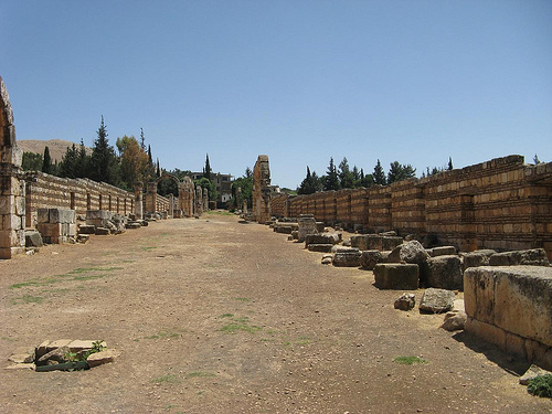
The city is divided into four equal quadrants
by two main 20-meter-wide avenues that intersect at right angles:
Cardo Maximus (north–south axis)
Decumanus Maximus (east–west
axis)
These thoroughfares are colonnaded, lined with arcades
supported by columns (many reused Byzantine spolia of varying types and
sizes), and flanked by approximately 600 shops set back about 4.5
meters. The streets sit atop main sewer collectors for efficient
drainage—an advanced engineering feature. Smaller streets further
subdivide the western quadrants.
Public and private buildings follow
a strict, hierarchical plan based on topography and functionality: the
caliph's grand palace and mosque occupy the highest (southeast) quadrant
for prominence and prestige; smaller palaces (harems) and baths are in
the lower northeast quadrant to facilitate wastewater evacuation;
residential and secondary functions fill the northwest and southwest.
The Tetrapylon: Heart of the City
At the central crossroads
stands a monumental tetrapylon—a four-way arch structure with four
groups of columns (plinths, shafts, and Corinthian-style capitals, all
spolia from earlier Roman/Byzantine periods). It served as a symbolic
gateway and focal point, evoking Roman triumphal architecture
(comparable to examples in Palmyra or Jerash). The tetrapylon's dramatic
ruins, often framed by restored colonnades, dominate the site and
highlight the city's Roman-inspired urban drama.
Major
Architectural Monuments
1. Grand Palace (Southeast Quadrant)
The
largest and most impressive structure (~59 × 70 m), believed to be the
caliph's official residence and administrative center.
Organized
around a central hosh (courtyard) of about 40 m², surrounded by a
peristyle (colonnaded walkway).
Preceded by arcades; features a
distinctive triple-arched façade on the western side (framing what would
have been three shops along the Cardo), with multi-level walls (up to
three stories preserved in parts).
Famous for its triple arcade
windows on the upper façade and Byzantine-influenced masonry:
alternating layers of stone with three courses of brickwork.
Interior
spaces included reception halls and living quarters. Excavations reveal
traces of decorative mosaics and finely carved limestone. Parts have
been skillfully partially reconstructed.
2. Mosque (Adjacent to
Grand Palace)
Located directly north of the Grand Palace (~45 × 32 m
or 47 × 30 m), with a private entrance from the palace for the caliph.
Features a sanctuary with two aisles, side riwaqs (porticos), and a
northern riwaq. It had public entrances and followed early Islamic
mosque layout principles while incorporating local techniques.
3.
Small Palace / Harem and Associated Structures (Northeast and Northwest)
The almost-square Small Palace (~46 × 47 m) is noted for its richly
decorated central entrance and numerous ornamental fragments: engravings
of birds, seashells, acanthus leaves, vine tendrils, botanical motifs,
and occasional figural scenes (some now in museums).
Organized around
a square central courtyard with suites of rooms (five-room groups on
sides) and an adjacent indoor souk (market) with shops.
Additional
smaller palaces/harems in the northeast.
4. Public Baths
(Northeast Quadrant)
Built on the classical Roman model with a square
vestibule (changing/rest area supported by arcades), followed by cold,
warm, and hot rooms (frigidarium, tepidarium, caldarium).
The
vestibule doubled as a social forum. Some retain stunning in-situ
mosaics, showcasing Umayyad continuation of Late Antique bathing culture
adapted to Islamic hygiene practices.
Construction Techniques,
Materials, and Decoration
Materials: Primarily local limestone and
sandstone blocks. Extensive use of spolia (reused Roman/Byzantine
columns, capitals, and decorative elements).
Techniques: Robust
ashlar masonry with Byzantine-style alternating stone-and-brick courses
for stability and aesthetics. Arches, vaults, and peristyles are
prominent.
Decoration: Delicate Corinthian and composite capitals
with vine scrolls, acanthus, and botanical motifs; some zoomorphic or
figurative elements (reflecting a transitional phase before stricter
aniconism). Plaster and mosaic work added luxury.
The overall
aesthetic contrasts slender columns and elegant arches against the
massive Anti-Lebanon mountains, creating a striking visual effect.
Architectural Significance
Anjar exemplifies the Umayyad
caliphate's ambition to create monumental, functional cities that
projected power while adapting and evolving Late Antique
(Greco-Roman–Byzantine) traditions into a distinctly Islamic urban form.
Its short lifespan (less than 30–40 years) "froze" the architecture in
time, offering unmatched insight into 8th-century planning, engineering,
and cultural synthesis. Unlike other Lebanese sites with multi-period
layers, Anjar is purely Umayyad—making it a rare and pure architectural
laboratory.
History and What to Expect
Anjar was founded around 705–715 AD by
Umayyad Caliph Walid I as an inland commercial hub at the crossroads of
key trade routes (Beirut-Damascus and Homs-Tiberias). The city,
originally called Ayn al-Jaar ("spring of the rock"), followed a strict
Roman-inspired grid plan with walls, 40 towers, a central tetrapylon
(four-gated arch), palaces, a mosque, baths, and shops. It was never
fully completed and was abandoned after the Umayyads fell in 744 AD.
Archaeologists rediscovered it in the late 1940s. The site spans about
114,000 square meters (roughly 385 x 350 m) and shows a blend of Roman,
Byzantine, and early Islamic architecture—highlighting the transition to
Islamic art. Key features include:
The Grand Palace
(best-preserved, with a large courtyard and arcades).
The Tetrapylon
at the main crossroads.
Remains of smaller palaces/harems, baths
(with some mosaics), a mosque, and colonnaded streets.
Modern
Anjar is a welcoming Armenian community settled in the 1930s by
survivors of the Armenian Genocide (many from Musa Dagh). You'll find
Armenian Apostolic churches (e.g., St. Paul), cultural spots like the
Mousa Ler Ethnographic Museum and Anjar Art Gallery, parks, monuments,
and local hospitality. It's a peaceful contrast to the ancient ruins.
Best Time to Visit
Spring (March–May) and autumn
(September–November) offer mild weather, ideal for exploring ruins and
walking. Summers are hot and dry in the Bekaa Valley; winters can be
cooler with possible rain. Avoid peak summer heat and consider fewer
crowds outside holidays.
Safety and Travel Considerations
(Important)
Anjar lies near the Syrian border in the Bekaa Valley.
Many governments (e.g., US, Canada) advise against all or non-essential
travel to Lebanon due to regional instability, armed conflict risks,
terrorism concerns, and border issues. Check your government's latest
travel advisory before planning.
If you proceed:
Visit with a
reputable local guide or organized tour from Beirut for safety and
navigation through checkpoints.
The site itself is generally calm
with tight security, but the area requires caution.
Monitor news
closely; situations can change rapidly.
How to Get There
From
Beirut: About 1.5 hours by car (around 50–60 km east-southeast). Private
driver or guided day tour is easiest and recommended (often combined
with Baalbek and Ksara Winery).
Public transport: Minibuses from
Beirut to Chtoura/Zahle, then another to Anjar. Walkable from the modern
town center to the ruins (or short taxi). Possible as a day trip from
Zahle.
Driving: Feasible but involves chaotic roads and
checkpoints—have a local driver if possible.
Tours often include
entry, transport, and guiding for a hassle-free experience.
Visiting the Ruins
Hours and Tickets: Typically open daily (check
current times; sites like this are often 8 AM–sunset). Modest entry fee.
Time needed: 1–2 hours for a thorough visit. There's limited on-site
signage, so a guide enhances the experience significantly.
Highlights: Walk the Cardo Maximus (north-south axis), see the
tetrapylon, explore the Grand Palace, and imagine the bustling ancient
marketplace.
Tips: Wear comfortable walking shoes (uneven terrain,
some climbing possible). Bring water, hat, and sunscreen. Modest
clothing (shoulders/knees covered, especially near any religious
elements). Late afternoon can be quieter and great for photos.
Other Things to Do in Town
Explore the Armenian community: Visit the
church, museums (locals may open them personally—hospitality is
legendary), and handicraft spots.
Agro-tourism: Fields, possible
bicycle/donkey tours, picnics, or hikes in nearby mountain areas (e.g.,
quarry or panoramic trails).
Combine with nearby attractions: Baalbek
(impressive Roman ruins) and Ksara Winery for a full Bekaa day.
Accommodations and Food
Options are limited but welcoming. Hotel
Layali Al Shams gets strong mentions for comfortable rooms, great
breakfast spreads, and exceptional Armenian hospitality (e.g., manti
dumplings). Staff like Gassig and Vart are highlighted for going above
and beyond.
Food emphasizes Lebanese-Armenian flavors: fresh mezze,
grilled meats, manti, and home-style meals. Breakfasts are often
abundant. Few tourist restaurants in the modern town—tours may include
lunch, or ask locals for recommendations.
Practical Tips
Currency and payments: Lebanon has economic challenges—carry cash (USD
often preferred; exchange at black market rates via apps). ATMs can be
unreliable.
Language: Arabic primary; Armenian in the community.
English is spoken by many in tourism.
What to bring: Passport (for
checkpoints), modest attire, sun protection, comfortable shoes, power
bank, and any needed medications.
Photography: Ruins are
photogenic—respect rules (some areas may restrict climbing).
Sustainability: Support local businesses and the community; the site
benefits from responsible tourism.
Health: Standard precautions; tap
water is not always safe—stick to bottled.