Location: 18 km (11 mi) North of Beirut Map
Length: 9 km (6 mi)
Official site
Jeita Grotto (Arabic: مغارة جعيتا) is a vast karstic limestone cave
system in Lebanon, located in the Nahr al-Kalb river valley near the
town of Jeita, about 18 km (11 mi) north of Beirut. It consists of
two interconnected levels—lower (wet, river-filled) and upper (dry
galleries)—with a total explored length of nearly 9 km (some sources
note over 11 km after later surveys). The name "Jeita" derives from
Aramaic, meaning "roar or noise" (referring to the sound of the
underground river). The grotto is renowned for its spectacular
stalactites, stalagmites (including the world's longest known
stalactite at over 8 m), massive chambers (up to 120 m high in
places), and crystal-clear underground river, which supplies fresh
drinking water to more than a million people in the Beirut area.
The cave's story spans millions of years of geological formation,
prehistoric human activity, 19th-century rediscovery by Western
explorers, intense 20th-century speleological mapping by Lebanese
teams, development into a major tourist site, wartime disruption,
and its role today as a national symbol and natural wonder (it was a
finalist in the New7Wonders of Nature campaign).
Geological Origins (Millions of Years Ago)
The caves formed in the
Lower-Middle Jurassic Keserouane formation, a thick (about 1,000 m)
layer of dolomite and micritic limestone deposited around 150–200
million years ago. Karstification—the dissolution of limestone by
slightly acidic rainwater and groundwater—began after a Late
Jurassic–Early Cretaceous uplift exposed the rock to air. It was later
buried during the Cretaceous but reactivated during the Neogene uplift
of Mount Lebanon. The steep topography, high rainfall (>1,200 mm
annually), and a hydrogeological barrier (impervious Upper Jurassic
volcanic rocks and Lower Cretaceous sand) forced the underground river
to emerge at the surface, creating the large western chambers. The
system features large halls, meanders, rapids, collapses, and a Y-shaped
end with siphons. Formation continues slowly today through dripping
water depositing calcium carbonate.
Prehistoric and Ancient Human
Use
Though the deeper caves were unknown until modern times, the area
around Jeita shows clear evidence of prehistoric habitation.
Archaeological sites include:
Jeita I (a dry cave near the
entrance, excavated intermittently 1833–1910): Upper Paleolithic,
Neolithic, Chalcolithic, and Early Bronze Age artifacts (flint tools,
pottery, bones).
Jeita II (rock shelter, excavated 1864–1964):
Aurignacian (Upper Paleolithic) flint tools, bones, hearths; also late
Upper Paleolithic/early Mesolithic (Kebaran) material.
Jeita III
(deposit inside the entrance, found 1963 by the Speleo Club): Geometric
flint tools suggesting Natufian or later Mesolithic.
Jeita IV (rock
shelter): Looted Paleolithic material.
Vestiges of an ancient
foundry (likely for sword production) were discovered in a smaller cave
near the Nahr al-Kalb river, indicating the site was used in antiquity
for metalworking. The caves appear to have been abandoned long before
modern rediscovery, with no continuous occupation into historical eras.
Modern Rediscovery (1836)
The lower cave's underground river was
rediscovered in 1836 by Reverend William Thomson, an American
missionary. Venturing about 50 m (160 ft) inside, he fired a gunshot;
the resounding echoes convinced him of the cavern's vastness. Earlier
local knowledge may have existed (the area was sometimes called the
Grottos of Nahr al-Kalb), but Thomson's account marks the start of
documented modern exploration.
19th–Early 20th Century
Explorations (1870s–1940)
Systematic exploration began in the 1870s,
driven by interest in the water source:
1873–1874: W.J. Maxwell and
H.G. Huxley (engineers with the Beirut Water Company) and Reverend
Daniel Bliss (president of the Syrian Protestant College, later the
American University of Beirut) conducted two major expeditions. They
penetrated 1,060 m (3,480 ft) to an underground waterfall dubbed "Hell's
Rapids" (due to torrents crashing on sharp rocks). They left
inscriptions: names and the year on "Maxwell's Column" (a pillar 625 m
in) and a sealed bottle with expedition details on a stalagmite in the
"Pantheon" chamber (now encased in calcite).
1892–1940: Further
expeditions by English, American, and French teams reached about 1,750 m
(5,740 ft).
Progress was limited by the river, darkness, and
technical challenges.
Mid-20th Century: Lebanese Speleology and
Upper Galleries (1940s–1960s)
Post-WWII, Lebanese explorers took the
lead:
1951: The Speleo Club du Liban (Lebanese Caving Club) was
founded by Lionel Ghorra, Albert Anavi, Raymond Khawam, Sami Karkabi,
and others. It drove most subsequent mapping.
1958: Lower caverns
opened to the public (initially by boat). That same year, Lebanese
speleologists George Farra and Sami Karkabi discovered the upper
galleries—60 m (200 ft) above the lower cave—revealing a dry,
spectacular system with enormous formations.
In the 1950s–1960s,
the club (often with French collaborators) mapped the full system,
revealing ~9 km total. Studies in 1962 led to an access tunnel (dug
1968) and walkways designed by Lebanese artist/sculptor Ghassan Klink to
minimize environmental impact.
Tourism Development and Cultural
Role (1969 Onward)
January 1969: Upper galleries opened publicly. A
celebratory concert featured electronic music by French composer
François Bayle (organized by Klink). Later that year, German composer
Karlheinz Stockhausen performed. Other events included a 2008 classical
concert by Guy Manoukian.
The site became a premier tourist
attraction, with boat tours in the lower cave and walking paths above.
It boosted Lebanon's tourism economy and featured on stamps and in
media.
Lebanese Civil War and Closure (1978–1995)
The grotto
closed in 1978 amid the Lebanese Civil War. Both access tunnels and
surface buildings were used for munitions storage and military purposes.
It reopened in 1995 after renovations by a German company (Mapas),
equipped with modern facilities.
Reopening, Modern Status, and
Recent Events
Since 1995, Jeita Grotto has thrived as a key natural
and cultural site, drawing hundreds of thousands of visitors annually
(pre-disruptions). It supplies vital drinking water and symbolizes
Lebanon's natural heritage. Explorations continue, with the Speleo Club
and others pushing further passages.
In late 2025, an illegal wedding
venue event (October 31) by a Lebanese-Italian couple sparked national
outrage over potential damage to the fragile ecosystem. The site was
briefly closed for investigation but reopened on November 15 after
experts confirmed no harm.
Multi-Phase Geological History and Speleogenesis
The cave's
development reflects a complex tectonic and hydrological history tied to
the uplift of the Mount Lebanon range:
Initial exposure and early
karstification (Late Jurassic–Early Cretaceous): Local tectonic uplift
exposed the Keserouane strata to subaerial conditions. Rainwater,
charged with atmospheric and soil-derived CO₂, formed carbonic acid
(H₂CO₃) that infiltrated fractures and bedding planes, initiating
dissolution:
CaCO₃ (limestone) + H₂CO₃ + H₂O → Ca²⁺ + 2HCO₃⁻.
This
created proto-cavities along structural weaknesses.
Burial phase
(Cretaceous): The early karst features were buried under younger
sediments, halting active dissolution.
Reactivation and main cave
enlargement (Neogene–Quaternary): The final uplift of Mount Lebanon
(driven by the Arabia-Eurasia convergence along the Levant margin,
accelerating from ~85 Ma in the Late Cretaceous but peaking in the
Miocene–Pliocene) re-exposed and rejuvenated the system. Steep
topography and high annual precipitation (>1,200 mm) intensified
karstification. Groundwater flow, initially phreatic (fully water-filled
passages under pressure), transitioned to vadose (air-filled,
gravity-driven) conditions as base levels dropped with river incision.
A key structural control is the hydrogeological barrier at the Nahr
al-Kalb valley: impervious Upper Jurassic volcanic rocks and Lower
Cretaceous sands dip nearly vertically, forcing the underground river to
surface as the Jeita Spring (discharge 1–2 m³/s). This barrier
contributed to the formation of exceptionally large chambers (some >60 m
high and up to 500 m long, such as Thompson's Cavern and Grand Chaos).
Speleogenesis studies (e.g., geomorphological mapping of erosion
features like dissolution scallops, fluvial undercutting, and collapse
blocks) link cave levels to progressive downcutting of the Kelb River
valley, identifying multiple stages of canyon evolution during the
Pliocene–Quaternary. The system shows classic karst features: meandering
passages, rapids, siphons, and collapsed blocks floored in places.
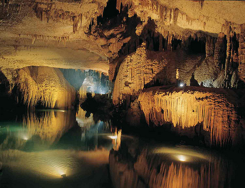
Two Distinct Levels
Lower Grotto (phreatic/active river level):
~60 m below the upper level, this is a dynamic, water-filled gallery
traversed by an underground river (the main source of the Nahr al-Kalb,
supplying drinking water to over a million people in Beirut). Visitors
explore ~500 m by electric boat across a smooth but occasionally
cascading river with features like the "Dark Lake." The river maintains
ongoing dissolution and sediment transport. In winter, high water levels
can close this section.
Upper Grotto (vadose/dry level): Accessible
via a 117 m tunnel and walkways, this level features three massive
chambers (White, Red, and the largest >120 m high). It is adorned with
spectacular speleothems and is dry except for dripping water that
continues to build formations.
Speleothems: Secondary Mineral
Deposits
The upper grotto's fame stems from its extraordinary
speleothems (cave formations) formed by calcite (CaCO₃) precipitation as
CO₂ degasses from dripwater, leaving supersaturated solutions to deposit
minerals. Growth rates are slow (typically <10 cm per 1,000 years), but
active deposition continues today.
Notable features include:
Stalactites (ceiling-hanging): The world's longest known stalactite (8.2
m) hangs in the White Chamber.
Stalagmites (floor-rising): Some
exceed 1 m; a dated 1.215 m specimen grew from ~12,000 to ~1,000 years
ago.
Columns (joined stalactite-stalagmite), flowstones/draperies
(sheet-like), curtains, mushrooms, and ponds.
Colors: Pure white
calcite contrasts with reddish hues from iron oxides (due to Lebanon's
warmer climate chemistry); other shades from trace minerals.
Scientific Insights and Paleoclimate Record
U/Th dating of
speleothems (e.g., a Holocene stalagmite from ~11.9–1.1 ka) reveals
layered growth tied to climate: wetter early Holocene conditions (low
δ¹⁸O and δ¹³C) transitioning to drier mid-Holocene (~6.5–5.8 ka). These
records align with regional Levant caves and reflect Mediterranean
sea-surface temperature influences and vegetation changes.
Ongoing
research uses geomorphology, dripwater monitoring, and radiometric
dating to reconstruct valley incision and karst evolution. The thin
overburden (60–75 m in places) raises stability concerns, but the site
remains a key natural laboratory for karst processes.
Opening Hours and Best Time to Visit
Hours: Typically 9:00 AM to
5:00 PM (summer) or until 4:00–4:30 PM (winter), Tuesday to Sunday.
Closed Mondays.
Seasonal notes: The lower grotto/boat ride often
closes in late winter (Jan–Feb) due to high water levels. The site may
close for maintenance or holidays—check ahead.
Best time: Weekday
mornings (especially Tuesday/Wednesday) right at opening for fewer
crowds and a more magical experience. Spring (April–June) and fall
(Sept–Oct) offer pleasant weather. Avoid weekends and peak summer
afternoons when tour buses arrive.
The cave stays a constant cool
16–20°C (61–68°F) and humid year-round—refreshing in summer but chilly
in winter.
Tickets and Costs (Approximate, as of Recent Info)
One ticket covers the cable car/train, upper gallery, lower boat ride
(when operating), and facilities:
Adults: ~$15 USD (around 18,150
LBP)
Children (under 12): ~$9 USD
Student/resident discounts
available with ID.
Bring clean, undamaged small USD bills—card
machines can be unreliable. Tickets are available on-site; advance
booking via tours helps during busy periods.
How to Get There
from Beirut
The drive takes 30–45 minutes via the coastal highway.
Options:
Taxi/Uber/Careem — Most convenient (~$35–60 round-trip with
waiting time recommended). Drivers often wait in the parking lot.
Private driver — Ideal for combining with Harissa (Our Lady of Lebanon)
or Byblos in one day ($80–120 for a full circuit).
Public — Service
taxi/minibus from Dawra to the highway turn-off, then a short local taxi
uphill (cheapest but less reliable).
No direct public bus to the
entrance. Rental car works but parking and traffic add hassle.
What to Expect: The Visit Step-by-Step
Arrival and Ascent: Park, buy
tickets, then take a short cable car (teleferique) up the hill for
valley and sea views (or a small train if the cable car is down—kids
love it).
Upper Gallery (Walking Tour): Enter via a 117m concrete
tunnel. Walk ~750m (of 2+ km total) on paved paths with stairs/ramps
through illuminated chambers. Highlights include the White Chamber
(longest stalactite), Red Chamber (iron-oxide colors, massive height),
and vast ceilings with draperies and columns. Lighting is artistic but
subdued.
Lower Gallery (Boat Ride): Descend (via train/walk) to board
a silent electric boat for a ~500m glide on the calm underground river.
The mirror-like water reflections of stalactites create a surreal
effect. The full explored river extends much farther, but public access
is limited.
Key Rules and Restrictions
No photography inside
the caves (cameras and phones must go in lockers). Reason: Prevent
algae/lampenflora growth from lights/flashes that damages formations.
Strict enforcement; photos allowed outside, on cable car, and in
gardens.
Do not touch formations—skin oils harm them.
Stay on
paths; no swimming or approaching the water in restricted areas.
Practical Visiting Tips
What to wear/bring: Comfortable closed-toe
shoes (paths can be damp/slippery). Light jacket or layers (temperature
drop is noticeable). No need for a flashlight—the lighting is excellent.
Accessibility: Cable car and grounds are mostly accessible, but upper
gallery has stairs/gradients and the boat requires steps. Not ideal for
wheelchairs or severe mobility issues without assistance. Strollers are
impractical inside.
Families/Kids: Great for children—the boat,
train, and small on-site zoo/gardens add fun. Hold young kids securely
on the boat.
Health/Safety: The site is generally safe and
well-maintained. The river water is pristine but not for drinking
on-site. Listen to guides for any rules.
Crowds: Arrive early to beat
groups. Guided tours provide more context if desired.
Additional
Tips for an Optimal Experience
Combine with nearby sites (Harissa
cable car for views, Byblos for history) for a full day.
Eat at
on-site cafes or nearby spots—facilities include restrooms, a gift shop
(postcards/books of pro photos), and viewing areas.
Check the
official site or recent updates, as the grotto has reopened after past
closures (e.g., post-2025 incidents).
Respect the site: It’s not just
a tourist spot but a vital water source and fragile ecosystem.