Location: Chiang Mai Province Map
Area: 1,123 km²
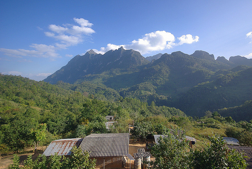
Pha Daeng National Park, located in Chiang Mai Province, Thailand, is a vast and relatively remote protected area known for its rugged mountainous terrain, diverse ecosystems, and rich biodiversity. Established on November 2, 2000, and originally named Chiang Dao National Park, it was later renamed Pha Daeng National Park. Covering approximately 1,123 to 1,225 square kilometers (depending on sources), the park spans the Chiang Dao, Wiang Haeng, and Chai Prakan districts, abutting the Myanmar border in the far north of the province.
Pha Daeng National Park is situated in the Pha Daeng mountain areas
of the Daen Lao Range, near the border with Myanmar and just north of
the Chiang Dao Wildlife Sanctuary. The park encompasses a complex and
dramatic mountainous landscape, with elevations ranging from
approximately 300 meters to 1,794 meters at the summit of Doi Puk
Phakka, its highest peak. Some sources also mention Doi Kham Fa (or Doi
Kham Fah) as a significant peak, reaching up to 1,834 meters, making it
another prominent feature for hikers and campers.
The park’s
terrain is characterized by:
Eastern Mountains: Predominantly
sedimentary rock formations, including peaks like Doi Thumglab, Doi
Huatoe, Doi Khunhuay Sai, Doi Phadang, Doi Thum Ngob, and Doi Danfak.
Western Mountains: Covered in dense forest, with notable peaks such as
Doi Khampra, Doi Pukphukka, Doi Lekjee, Doi Sankiew-khompra, Doi Kiew
Who Lom, Doi Tuay, and Doi Yang Klor.
Watersheds: The park is a
critical watershed for three major rivers—Ping, Fang, and Taeng—with the
Ping River flowing through its central section. The headwaters of the
Ping, known as Khun Ping, originate at the Yod Doi Tuai sightseeing spot
in the park’s northern region.
The park’s geological features,
including limestone caves, cliffs, and waterfalls, add to its scenic and
ecological diversity. Its proximity to the Myanmar border and the
southern slopes of Doi Ang Khang in the east further enhance its
strategic ecological importance.
Pha Daeng National Park is a biodiversity hotspot, with a wide range
of habitats supporting diverse flora and fauna. The park’s ecosystems
are shaped by its varied altitudes, climate, and geology.
Flora
The park features several forest types, reflecting its ecological
complexity:
Dry Dipterocarp Forest: Found in lower elevations,
characterized by deciduous trees adapted to seasonal drought.
Mixed
Deciduous Forest: A blend of deciduous and evergreen species, common in
mid-elevation areas.
Pine Forest: Found at higher elevations,
particularly around Doi Kham Fa, adding to the scenic beauty.
Montane
Evergreen Forest: Dense, lush forests at higher altitudes, supporting
unique plant species.
Hill Evergreen Forest: Found in cooler, higher
regions, with moisture-loving plants.
Notable plant species include
bamboo, orchids, tamarind, and various ferns. The park also has a fern
house and herb garden near the Sri Sangwan Waterfall, though some
visitors note the herb garden is not well-maintained. The diverse
vegetation supports a rich ecosystem and provides habitats for wildlife.
Fauna
The park is home to a variety of wildlife, though some
species are elusive due to the park’s remote and rugged nature. Notable
animals include:
Mammals: Asian black bears, banteng, muntjac,
serow, Chinese gorals, deer, barking deer, porcupines, monkeys, and
squirrels. Larger mammals like red bulls and gaurs are also reported,
though sightings are rare.
Birds: The park is a haven for
birdwatchers, hosting both endemic and migratory species. Notable birds
include the gray saxony, blue-necked barbet, great firebird, and
yellow-headed bulbul. The park’s varied habitats make it ideal for
birding.
Other Wildlife: Butterflies, insects, and bats are abundant,
particularly in caves like Klab Cave, which houses large bat populations
alongside stalactites and stalactites.
The park’s relatively
undisturbed environment and low visitor numbers help preserve its
wildlife, making it a critical conservation area.
Pha Daeng National Park offers a range of natural and cultural
attractions, appealing to adventurers, nature lovers, and those seeking
tranquility. Below are the park’s highlights:
1. Sri Sangwan
Waterfall
Description: Located near the main park entrance, this
three-tiered, 20-meter limestone cascade is one of the park’s most
accessible and popular features. It resembles a smaller version of the
Sticky Waterfall (Nam Tok Bua Tong) near Chiang Mai, with pools for
cooling off and a scenic setting ideal for picnics.
Historical Note:
The waterfall was named by Her Royal Highness, the Princess Mother,
during a visit to inaugurate a police station in the area, where she
stopped for lunch.
Visitor Experience: Visitors can walk down
alongside the falls, with a basin at the top level suitable for swimming
(though not recommended for children due to climbing challenges). The
area is surrounded by lush vegetation, colorful flowers, and
butterflies, creating a serene atmosphere.
2. Pong Arng Hot
Springs
Description: Located about 3 km south of the Sri Sangwan
Waterfall, these natural hot springs feature two bathing ponds with
temperatures ranging from 58°C to 64°C. The pools are set under trees,
giving them a natural, rustic appearance, though some visitors note
occasional debris from the hot spring stream.
Facilities: Toilets,
changing rooms, and parking are available. A new filtered, tiled pool
system is under development nearby but was not yet open as of recent
reports.
Visitor Tips: The entrance fee (100 THB per person, 30 THB
for car parking) covers both the hot springs and the waterfall. Women
are advised to wear modest clothing (e.g., T-shirts and shorts over
swimwear) to respect local customs.
3. Caves
Klab Cave: A
10-meter-wide cave with numerous bats and impressive stalactites and
stalagmites. Its accessibility makes it a popular stop for cave
explorers.
Doi Klang Muang Cave: A larger, 1-km-deep cave with a high
cliff entrance, requiring caution due to its depth and rugged terrain.
Pha Daeng Cave and Long Cave: These caves offer opportunities to explore
limestone formations and experience the park’s geological history.
Visitors should be prepared for cool temperatures and potential
slipperiness, especially during the rainy season.
4. Hiking
Trails and Viewpoints
Doi Kham Fa Peak Loop: The most popular hiking
trail, rated 4.1 stars on AllTrails, spans 9.2 miles with a 2,526-foot
elevation gain. It leads to the breathtaking Doi Kham Fa Peak, passing
through forests, waterfalls, and diverse wildlife. Hikers are advised to
wear long, breathable clothing to protect against mosquitoes.
Ping
Canyon Extended Trail: The longest trail at 15.3 miles, with a
3,198-foot elevation gain, offering a challenging adventure through
rugged terrain.
Yod Doi Tuai Sightseeing Spot: Located in the
northern part of the park, this viewpoint offers stunning views of the
Ping River’s headwaters and surrounding forests. It’s ideal for
photography and experiencing cool, misty mornings.
Doi Kham Fa
Viewpoint: Known for its spectacular sunrise views, this high-altitude
spot is perfect for camping and admiring pine forests and foggy
landscapes.
5. Other Features
Fern House and Herb Garden: Near
the Sri Sangwan Waterfall, these provide educational insights into the
park’s plant life, though maintenance can be inconsistent.
Visitor
Center: Located near the main entrance, it offers maps, pamphlets, and
bilingual information, making it a good starting point for planning
visits.
Pha Daeng National Park offers a range of activities for different
interests and fitness levels:
Hiking and Trekking: With trails
like Doi Kham Fa Peak Loop and Ping Canyon Extended Trail, the park is
ideal for adventurers. Trails vary in difficulty, catering to both
casual hikers and experienced trekkers.
Camping: Camping is popular,
especially at Doi Kham Fa, where visitors can enjoy sunrise views and
foggy mornings. The park provides tent rentals and designated camping
zones, with shelters available for groups (600–2,500 THB).
Birdwatching: The park’s diverse bird species attract ornithologists and
casual birders, particularly during migration seasons.
Cave
Exploration: Caves like Klab and Doi Klang Muang offer opportunities to
explore geological formations, though visitors should exercise caution.
Relaxation and Picnicking: The Sri Sangwan Waterfall and hot springs
provide serene spots for relaxation, with picnic areas available.
Photography: The park’s landscapes, waterfalls, and viewpoints are
perfect for capturing stunning natural scenery.
Local Communities: Indigenous and local communities near the park
maintain traditional practices and knowledge of the forest ecosystems,
contributing to conservation efforts. Their involvement helps preserve
the park’s natural resources and cultural heritage.
Naming History:
The park’s original name, Chiang Dao National Park, was changed to Pha
Daeng to reflect its distinct identity within the Pha Daeng mountain
range. The Sri Sangwan Waterfall’s name, bestowed by the Princess
Mother, adds a royal historical connection.
Conservation: Established
as a national park to protect its ecosystems, Pha Daeng plays a vital
role in preserving northern Thailand’s biodiversity and watersheds,
which are critical for regional agriculture and water supply.
Access
Location: The park is accessible via Route 1178, about 15
km from Arunothai or 30 km from Chiang Dao. From Chiang Mai city, take
Highway No. 107 (Chiang Mai-Fang), turn left at the 79th kilometer onto
Highway No. 1178, and continue for 24 km. The main entrance is 159
meters before Ban Na Wai.
Transportation: Visitors can drive, rent a
car with a driver, or take a songthaew (shared taxi) from Chiang Dao.
Public transportation is limited, so private vehicles are recommended
for flexibility.
Entrance Fees
Adults: 100 THB (foreigners),
20 THB (Thai)
Children: 50 THB (foreigners), 10 THB (Thai)
Vehicles: 30 THB (car), 20 THB (motorbike)
The fee covers access to
both the Sri Sangwan Waterfall and Pong Arng Hot Springs.
Facilities
Accommodations: Bungalows (600–2,500 THB) and tent rentals
are available. Shelters accommodate groups of up to 20, with bookings
possible through park rangers (phone: 053-317498, 053-261466; email:
phadang_np@hotmail.com).
Amenities: The visitor center, toilets,
changing rooms, and parking are available near the main entrance. Food
vendors are scarce, so visitors should bring their own supplies.
Dining: The park offers Thai, made-to-order, and local cuisine, with
cooking spaces for visitors to prepare their own meals.
Climate
and Best Time to Visit
Climate: The park has a cool climate,
averaging 20–25°C, with winter temperatures dropping to 8–15°C. The
rainy season (June–October) enhances waterfall flow but makes trails
slippery, while the cool season (October–February) is ideal for hiking
and camping.
Best Time: November to February offers pleasant weather,
clear views, and vibrant greenery.
Tips for Visitors
Clothing:
Wear sporty, warm clothing (jackets, trousers, sturdy shoes) due to cool
temperatures and rugged terrain. Avoid short or revealing outfits,
especially at the hot springs, to respect local customs.
Safety:
Exercise caution in caves and on trails, especially during the rainy
season. Bring insect repellent for hikes.
Supplies: Pack food, water,
and a camera, as amenities are limited. A jacket or scarf is recommended
for cooler mornings.
Respect Nature: Follow park guidelines to
preserve the environment, such as avoiding littering and respecting
wildlife habitats.
Remoteness: The park’s location makes it less commercial and less
crowded than other Chiang Mai national parks, but it also means limited
facilities and transportation options.
Maintenance: Some areas, like
the herb garden, may lack upkeep, and the new hot spring pools are not
yet operational, which could affect visitor experience.
Accessibility: Some attractions, like deep caves and high peaks, require
physical fitness and caution, making them unsuitable for all visitors.