Location: Kanchanaburi Province, 100 km (62 mi) Northwest of Kanchanaburi
Tel. 0-3451-6163-4
Info: TAT, Kanchanaburi Tel. 0-3451-1200
Sai Yok National Park (also spelled Saiyok) is a scenic 958 km² protected area in Sai Yok District, Kanchanaburi Province, western Thailand. It borders Myanmar and forms part of the massive Western Forest Complex. The park is renowned for its lush deciduous and dry evergreen forests, bamboo groves, the Khwae Noi River (a tributary of the River Kwai), waterfalls cascading into the river, limestone caves, and historical remnants of the World War II Death Railway.
Best Time to Visit
Cool/dry season (November–February): Ideal
conditions with pleasant temperatures (~25°C), clear skies, morning mist
over the river, and comfortable hiking/swimming. This is peak time for
most visitors.
Rainy season (May–October): Waterfalls flow strongest
(especially June–October), but trails can be slippery/muddy, some caves
may close, and river currents strengthen. Good for dramatic scenery if
you don’t mind occasional showers.
Hot season (March–May): Avoid if
possible—high heat and humidity make outdoor activities tiring.
Weekdays are far quieter than weekends or Thai holidays, when locals
flock for picnics and swimming.
Getting There
The main visitor
centre is ~100 km northwest of Kanchanaburi town, 19 km north of
Hellfire Pass, and 3 km off Highway 323 beside the Khwae Noi River.
From Bangkok: Train from Thonburi Station to Nam Tok (end of the Death
Railway line; ~5–6 hours, ~100 THB third-class). Then songthaew (shared
pickup) or motorbike taxi to the park (~150–700 THB depending on
private/shared). Buses/minivans to Kanchanaburi first (2–3 hours), then
onward bus toward Sangkhlaburi, alight at the park turnoff, and
motorbike taxi the last 3 km.
From Kanchanaburi: Private
taxi/songthaew (~900–3,000 THB for a day trip or one-way), motorbike
rental (~250 THB/day), or join a tour combining Hellfire Pass, Erawan,
etc.
Car/motorbike: Easy drive on good roads from Kanchanaburi.
International driver’s license needed for car rental.
Public
transport reaches the highway; the final stretch often requires a short
taxi ride. Park staff can help arrange returns.
Entrance Fees and
Hours
Foreign adults: 300 THB; children (3–14): 150 THB (as of recent
info; confirm on-site).
Thai nationals: Much lower (60/30 THB).
Vehicles: Car ~30 THB, motorbike ~20 THB.
Hours: Visitor centre and
main areas 8:00 AM–4:30 PM daily (park itself is more open, but
facilities close). Some caves may close in heavy rain.
Pay at the
visitor centre or entry points. The fee supports maintenance, though
some visitors find it steep for the accessible portion.
Main
Attractions and Activities
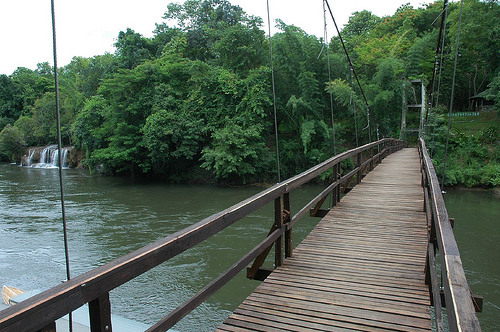
Sai Yok Yai & Sai Yok Lek Waterfalls:
Small but picturesque falls dropping into the Khwae Noi River.
Suspension bridge for views; short trails and picnic spots. Sai Yok Lek
(larger despite the name) is a short longtail boat ride downstream (~300
THB). Best after rain; swimming possible (cold water, modest local
attire common).
Caves: Khang Khao Cave (short trail from visitor
centre; home to rare Kitti’s hog-nosed bat, the world’s smallest). Dao
Wadung Cave (longer, boat or drive access; stalactites, chambers). Bring
a strong flashlight/headlamp. Lawa Cave further south (boat access).
River Experiences: Longtail boat trips (~400–1,200 THB), bamboo rafting,
kayaking, or tubing. Raft houses offer scenic floats.
Hikes & Nature:
Short signposted trails (up to 2 km) around visitor centre to springs,
viewpoints, and railway remnants. Longer jungle treks possible with
guides/tours.
Historical Sites: Death Railway bridge remnants and
artifacts nearby.
Wildlife: Rare sightings near visitor centre
(monitor lizards, deer); deeper in: elephants, gibbons, hornbills,
unique crabs, and bats. Not a prime spotting park but peaceful.
Nearby (often combined): Sai Yok Noi Waterfall (technically separate,
accessible from Nam Tok station), Hellfire Pass, Prasat Mueang Sing
historical park.
Where to Stay
Park Bungalows: Basic, 4–7
person units (800–3,000 THB). Book via DNP website (Thai banks/7-Eleven
payment) or email. 20% discount Mon–Thu. Check location—some are
walkable to centre.
Camping: Spacious site; own tent 30 THB/day or
rent (tent ~225 THB, sleeping set ~60 THB/person). Basic restaurants
nearby.
Raft Houses (Floating Hotels): Signature experience—serene
river views, limited electricity (oil lamps), meals included at some.
Examples: River Kwai Jungle Raft, The Float House. Activities like Mon
tribe visits, elephant feeding (ethical options preferred), massage.
Access by complimentary boat. Book ahead; pricier but memorable.
Private raft houses inside/near the park offer better ambiance than some
park options.
Practical Visiting Tips
What to Bring:
Comfortable walking shoes (trails can be uneven/slippery),
swimwear/towel, quick-dry clothes, insect repellent (mosquitoes
year-round), flashlight for caves, sunscreen, hat, reusable water
bottle, snacks (limited options), rain gear in wet season, modest
clothing for local respect.
Health & Safety: Stay on trails, watch
for slippery rocks near falls, avoid swimming in strong currents.
Wildlife is present but not aggressive—respect distance. Pharmacies
limited; bring any meds.
Food: Basic Thai restaurants at visitor
centre (open ~8 AM–4:30 PM). Raft houses provide meals. Bring picnic
supplies for flexibility.
Crowds & Etiquette: Weekends busy with Thai
families—picnics, swimming. Respect nature (no littering), quiet hours
on rafts, and local customs.
Accessibility: Main areas reachable with
some walking; caves/trails not ideal for mobility issues. Not heavily
developed.
Tours: Good for transport/logistics if independent travel
feels daunting. Many combine with Kanchanaburi sites.
Budget:
Entrance + transport + basic stay/meals: 1,500–4,000+ THB/person/day
depending on style. Raft stays push higher.
Sustainability: Support
ethical operators (no exploitative elephant activities), use reef-safe
products if swimming, minimize plastic.
Royal Visit and Cultural Fame (Late 19th Century)
King Rama V
(Chulalongkorn, r. 1868–1910) visited the Sai Yok waterfalls twice—once
in 1877 and again in 1888—traveling by boat along the Khwae Noi River.
He bathed in the falls (primarily Sai Yok Yai), an event that elevated
the site’s cultural status. A bust of the king and a replica of his
royal boat now stand at the waterfall as memorials.
The visit
inspired a composer (one of the king’s followers or contemporaries) to
create a song or poem praising the waterfall’s ethereal beauty, helping
make “Sai Yok” a symbol of natural splendor in Thai literature and
folklore. This royal connection gave the area early fame as a scenic
destination long before formal protection.
World War II and
Japanese Occupation (1942–1945)
The most dramatic chapter occurred
during Japan’s occupation of Thailand. Japanese forces selected the
remote, rugged Sai Yok area for part of the infamous Burma Railway (also
called the Death Railway or Thailand–Burma Railway), a strategic 415-km
supply line linking Thailand to Burma (Myanmar) to support the war
effort in Southeast Asia.
Deforestation and labor: Teak forests
along the lower Khwae Noi River were heavily logged to support railway
construction and other military needs. Allied prisoners of war (POWs),
forced Asian laborers (romusha), and local workers endured brutal
conditions, building embankments, bridges, and tracks through dense
jungle and limestone terrain.
Japanese camp and infrastructure: A
Japanese troop camp operated within the current park boundaries.
Remnants of a railway bridge (foundations and embankment sections) and
the camp site survive as tangible evidence. Trails in the park pass
interpretive signs and these ruins, including foundations near caves and
viewpoints. Nearby sites like Kinsayok (along the railway route)
involved large embankments and, in some sections, the presence of women
and children among laborers.
The railway’s Thai section ended at
Nam Tok (near Sai Yok Noi), and much of the line beyond was later
dismantled. The human cost was immense—tens of thousands died from
disease, starvation, and overwork—making the area a poignant reminder of
wartime suffering. These remnants are now key historical attractions
alongside the park’s natural features.
Post-War Recovery and
Replanting (1945–1970s)
After Japan’s surrender in 1945 and the war’s
end, Thailand focused on rehabilitating war-damaged landscapes. In 1954,
the deforested teak areas along the Khwae Noi River were replanted,
allowing secondary forest to regenerate. This effort helped restore the
ecosystem in what would become the park.
Exploration continued in the
mid-20th century:
Caves such as Tham Dao Wadung were discovered
around 1972.
In 1973, scientists first documented Kitti’s hog-nosed
bat (one of the world’s smallest mammals) in the park’s limestone caves,
highlighting its biodiversity value.
In 1978, the park area
gained international attention when filmmakers shot the Russian roulette
scenes for the Oscar-winning movie The Deer Hunter here (though the film
is set in Vietnam).
Establishment as a National Park (1980
Onward)
By the late 1970s, growing awareness of Thailand’s natural
heritage, combined with the area’s scenic waterfalls (Sai Yok Yai, Sai
Yok Lek, and the nearby Sai Yok Noi/Khao Phang), caves (including the
large Tham Lawa), and historical sites, led to its protection. On 27
October 1980, the Royal Gazette declared Sai Yok National Park
Thailand’s 19th national park, under the Department of National Parks,
Wildlife and Plant Conservation.
The park’s creation preserved the
recovering forests (mostly mixed deciduous, with patches of evergreen
and dipterocarp), limestone mountains (highest point Khao Ro Rae at
1,132 m), river ecosystems, and WWII relics. It also integrated into the
broader Western Forest Complex, linking it with neighboring parks like
Thong Pha Phum and Erawan.
Since 1980, Sai Yok has developed as a
popular eco-tourism site with raft houses on the Khwae Noi, short hiking
trails, caves, and wildlife viewing (including tigers, elephants, and
over 200 bird species in the broader complex). Visitor numbers have
grown steadily; in 2024, the park recorded about 67,700 visitors.
Historical sites remain accessible via trails from the visitor center,
blending nature and wartime memory.
Sai Yok National Park is a significant protected area in western
Thailand, renowned for its dramatic karst topography, riverine
landscapes, extensive cave systems, and dense forests within the
Tenasserim Mountain Range. It lies in Sai Yok District of Kanchanaburi
Province, approximately 100 km northwest of Kanchanaburi town and near
the small town of Nam Tok Sai Yok Noi. The park forms part of the vast
Western Forest Complex (a transboundary protected area spanning Thailand
and Myanmar totaling around 18,730 km²) and borders Thong Pha Phum
National Park to the north, Khuean Srinagarindra and Erawan National
Parks to the east/southeast, and Myanmar’s Tanintharyi Division to the
west.
The park covers approximately 500 km² (312,500 rai), though
some sources cite larger figures up to 958 km²; the 500 km² figure
aligns with official designations and most references. Established as a
national park in 1980, it protects a diverse and rugged landscape shaped
by ancient geological processes and a tropical monsoon climate.
Topography and Geology
Sai Yok National Park features steeply rising
limestone mountains belonging to the Tenasserim Range (part of the
larger Dawna-Tenasserim mountain system along the Thai-Myanmar border).
The terrain is classic karst topography—characterized by rugged
limestone cliffs, folded rock formations, sinkholes, and extensive
underground cave networks formed by the dissolution of Permian-era
limestone over millions of years in the humid tropical environment.
Elevation varies dramatically: the average is around 399 meters above
sea level, with a range from as low as 58 m along the river valleys to a
maximum of about 1,284–1,328 m at the western border with Myanmar. One
named high point is Khao Ro Rae (around 1,132 m). The mountains create
steep slopes and narrow valleys, with prominent limestone cliffs
towering directly above riverbanks in many areas.
This karst
landscape results in highly dissected terrain—sharp ridges, deep gorges,
and dramatic escarpments—making much of the interior relatively
inaccessible except via trails, river travel, or specific access points.
The eastern sections near the Khwae Noi River are lower and more gently
sloped, while the western and central areas become increasingly
mountainous and rugged toward the Myanmar border.
Hydrology:
Rivers and Waterfalls
The Khwae Noi River (a major tributary of the
famous River Kwai) is the dominant hydrological feature, flowing through
the eastern portion of the park and creating scenic river valleys lined
with raft houses and viewpoints. The river’s clear waters and seasonal
flow support rafting, swimming, and scenic boat trips, with misty
mornings common in cooler months.
Several notable waterfalls cascade
into or along the Khwae Noi:
Sai Yok Yai Waterfall (also called
Namtok Sai Yok Yai) drops about 10–15 meters directly into the river
from a tributary stream, creating a dramatic plunge visible from
suspension bridges and raft houses. It is best viewed in the rainy
season (June–October) when flow is strongest.
Sai Yok Lek lies just
downstream and offers similar scenic cascades into the river.
Sai Yok
Noi (Khao Phang Waterfall), slightly north of the main park entrance
area, features 15-meter falls over collapsing limestone cliffs, fed by
underground springs.
These waterfalls highlight the karst
hydrology: many are fed by subterranean streams and springs emerging
from limestone fissures.
Climate
Sai Yok has a tropical
monsoon climate. Average temperatures range from about 15.4°C (lowest)
to 31.1°C (high), with a mean around 27°C. April is the hottest month.
The rainy season runs from mid-May to October (peaking
September–October), bringing an average annual rainfall of about 975 mm,
which swells rivers and waterfalls while nourishing the forests. The
cool/dry season (November–February) features cooler temperatures and
morning mist, while March–May is hot and dry. Heavy fog often blankets
the mountains in winter.
Vegetation and Ecosystems
The park’s
vegetation reflects its elevation and rainfall patterns. Approximately
85% is mixed deciduous forest, 13% dry evergreen forest, and 2% dry
dipterocarp forest, with bamboo thickets common throughout the
mountainous zones. Lower riverine areas along the Khwae Noi feature teak
plantations replanted in the 1950s after wartime deforestation.
The
forests are dense, supporting tall trees (e.g., Pterocarpus macrocarpus,
Dipterocarpus species), understory shrubs, and epiphytes. Limestone
outcrops create microhabitats with specialized plants adapted to thin
soils and rocky surfaces.
Notable Karst Features: Caves and
Cliffs
The limestone geology has produced dozens of caves, many
accessible to visitors (with lanterns or guided tours recommended):
Tham Lawa (Lawa Cave): The largest, stretching about 500 meters with
multiple huge chambers filled with impressive stalactites and
stalagmites.
Tham Dao Wadung (Dao Wadung Cave): Around 100–240 meters
long with eight chambers of dramatic formations; bats often emerge at
dusk.
Tham Khang Khao (Bat Cave): Home to the tiny Kitti’s hog-nosed
bat (one of the world’s smallest mammals), discovered here in the 1970s.
Limestone cliffs line many river sections, creating sheer walls that
rise abruptly from the water and support unique cave ecosystems.
Sai Yok National Park (also spelled Saiyok) is a biodiverse protected
area in Sai Yok District, Kanchanaburi Province, western Thailand, about
100 km northwest of Kanchanaburi town. It forms part of the expansive
Western Forest Complex—a transboundary protected area spanning Thailand
and Myanmar—that allows wildlife to move freely across borders. The park
covers roughly 500–958 km² (sources vary slightly on exact boundaries),
featuring steep limestone mountains of the Tenasserim Range (highest
point around 1,100–1,300 m), the Khwae Noi River (a tributary of the
famous River Kwai), numerous waterfalls, caves, and karst formations.
These diverse habitats—forests, riverine zones, streams, and
caves—support rich flora and fauna, though many larger mammals are
elusive and concentrated in remote interior areas near the Myanmar
border.
Flora: Forest Types and Vegetation
The park’s
vegetation reflects its seasonal tropical climate (distinct wet and dry
seasons). Three main forest types dominate:
Mixed deciduous forest
(≈85% of the park): The predominant type at mid-elevations (150–600 m).
Characteristic trees include Bombax anceps (silk-cotton tree), Canarium
subulatum, Cassia garrettiana, Croton persimilis, Dialium
cochinchinense, Fernandoa adenophylla, Homalium tomentosum,
Lagerstroemia tomentosa, Lophopetalum duperreanum, Pterocarpus
macrocarpus (Burmese rosewood), Schleichera oleosa, Siphonodon
celastrineus, and Terminalia triptera. Many of these shed leaves in the
dry season, creating open, sun-dappled canopies.
Dry evergreen forest
(≈13%): Found in wetter, more sheltered areas. Key species include
Anisoptera spp., Aporosa villosa, Castanopsis spp., Dillenia aurea,
Dipterocarpus alatus and D. turbinatus (dipterocarps), Irvingia
malayana, Lagerstroemia calyculata, Millettia brandisiana, Polyalthia
viridis, Schima wallichii, Syzygium cumini, and Syzygium megacarpum.
These provide denser, year-round canopy cover and support epiphytes and
lianas.
Dry dipterocarp forest (≈2%): The rarest type, on drier
ridges, with Adina cordifolia, Artocarpus lacucha, Bombax valetonii,
Canarium spp., Chrozophora tinctoria, Dillenia indica, Dipterocarpus
obtusifolius and D. tuberculatus, Ficus microcarpa, Flemingia
sootepensis, Lannea coromandelica, and Quercus kerrii.
Bamboo
groves are common throughout, especially in disturbed or transitional
areas, adding to the understory density. Along the Khwae Noi River, teak
(Tectona grandis) forests were historically logged during World War II
but replanted in the 1950s; lower riverbanks support riparian
vegetation. Limestone outcrops host specialized flora, while the overall
biomass in mature stands can be very high. The park’s forests are lush
and green in the wet season (May–October) but take on golden-brown tones
in the dry season.
Fauna
Mammals
Sai Yok supports over
50–58 mammal species, many of which are threatened or rare. Sightings
near visitor areas are limited (mainly water monitors and sambar deer
along the river), but the remote interior and Myanmar border harbor
larger populations.
Iconic and rare species: Kitti’s hog-nosed
bat (Craseonycteris thonglongyai), the world’s smallest mammal (body
~2–3 cm long, weight ~2 g, wingspan ~10 cm). It roosts in specific
limestone caves (e.g., near the visitor centre or Tham Kang Khao/Dao
Wadung) and was discovered in 1973. It feeds on insects and is harmless
to humans.
Large mammals: Asian elephant (Elephas maximus),
Bengal tiger (Panthera tigris tigris; camera-trapped but very rare),
leopard (Panthera pardus), dhole (Cuon alpinus), clouded leopard, Asian
black bear, and Malayan sun bear. These roam the deeper forests and
migrate across the border.
Ungulates and smaller herbivores: Sambar
deer (Rusa unicolor), barking deer/muntjac, wild boar (Sus scrofa), and
Indochinese serow (Capricornis milneedwardsii—a goat-antelope).
Primates: White-handed (lar) gibbon (Hylobates lar), stump-tailed
macaque, crab-eating macaque, and Tenasserim lutung (dusky leaf monkey).
Gibbons are often heard calling at dawn/dusk.
Other notable
species: Malayan porcupine, red and black giant flying squirrels, slow
loris (vulnerable), and various civets and bats.
Birds
The
park records 106–209 bird species (depending on the source;
thainationalparks.com lists ~106 verified, Wikipedia notes up to 209).
It is not primarily a birdwatching hotspot but offers good diversity
across forest, river, and edge habitats.
Notable families and
examples include:
Hornbills: Oriental pied hornbill (Anthracoceros
albirostris)—a charismatic frugivore often seen in canopy.
Kingfishers: Banded kingfisher, white-throated kingfisher, black-capped
kingfisher.
Barbets and woodpeckers: Blue-eared barbet, lineated
barbet, greater flameback, black-naped woodpecker.
Parrots and
allies: Grey-headed parakeet.
Babblers and laughingthrushes: Greyish
limestone babbler (tied to karst habitats), large scimitar babbler,
greater and lesser necklaced laughingthrushes.
Others: Drongos
(greater racquet-tailed), flycatchers, sunbirds, bulbuls, bee-eaters,
raptors (besra, eastern buzzard), owls, and common river/pond birds like
herons, egrets, and lesser whistling duck.
Reptiles and
Amphibians
Reptiles are diverse due to caves, rivers, and forests:
Snakes: Kanburi pit viper (endemic/rare), cave racer, Brongersma’s blood
python, Indochinese ground snake, Siamese cat snake, speckle-bellied
keelback.
Geckos: Several locally restricted species, including Sai
Yok bent-toed gecko (Cyrtodactylus saiyok), yellow-headed rock gecko,
tiger bent-toed gecko, and Nutaphand’s red-eyed gecko.
Others: Water
monitors, Asian forest tortoise.
Amphibians include a variety of
frogs adapted to streams, puddles, and forest floor: Asian grass frog,
banded bullfrog, Malayan flying frog, giant Asian river frog, puddle
frog, dark-sided chorus frog, and various Bufo toads.
Aquatic and
Invertebrate Life
The Khwae Noi River and small streams support fish
(various species, though not exhaustively listed) and a standout
endemic: the Queen (or Regal) crab (Thaiphusa sirikit, also called Poo
Rachinee). Discovered in 1983 and named after Queen Sirikit, it is
strikingly colorful—often with a white body, purple stripe, and red legs
(or red/white/blue variations). It inhabits forest streams near the
campsite and is a highlight for visitors.
Other invertebrates include
large black scorpions (visible on trails in the morning) and numerous
insects, butterflies, and spiders that contribute to the food web.
Ecological Context and Conservation
Sai Yok’s biodiversity is
enhanced by its position in a large, continuous forest block, limestone
geology (providing cave roosts and specialized microhabitats), and river
systems. Many species are IUCN-listed as vulnerable, endangered, or
data-deficient (e.g., tiger, elephant, slow loris, certain geckos).
Wildlife trafficking, habitat fragmentation, and tourism pressure are
ongoing concerns, but the park’s protected status and connection to
Myanmar help maintain populations.